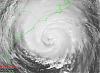
Hank makes a great point about not letting your guard down in N. FL and GA. If Fay gets forced far enough east to reemerge over the western Atlantic ocean then we may see some slow re-intensification and thus impacts on regions in coastal northeast FL and coastal GA that have been left alone for quite some time. We saw some pretty drastic shifts in the models today, first starting with the GFDL and HWRF going off the deep-end this morning not being able to handle the big ridge building in from the northeast predicted by the GFS and NAM. Radar imagery looks impressive with the single wide convective band trying to wrap around the LLC, it appears that Fay will reach land before this happens however. How about that rain band / feeder band stretching from the storm all the way SE and S to off the N. coast of Cuba? I'm anxious to see what NHC thinks about the track variations with this next set of model runs (00Z). Will Fay make it to the western Atlantic? Will she stay inland and get pushed back towards the W.? The drought here in the western Carolinas could really use 4-5 inches of rain from her.
|