MikeC
|
| (Admin) |
| Wed Aug 24 2011 09:49 AM |
|
|
5:00AM EDT 25 August 2011 Update
Irene Remains a category 3 hurricane, and tropical storm and hurricane watches are now posted for South Carolina and North Carolina, respectively.
8:30AM EDT 24 August 2011 Update
Irene is now a category 3 major hurricane with sustained winds of 115Mph after the two recon planes flying in Irene found it intensifying once again.
The track thinking is similar to earlier, with Irene stair-stepping west northwest to northwest during the day.
Original Update
Hurricane Irene strengthened overnight and is one again a category 2 hurricane, with 110MPH Winds and 962 pressure. It is expected to become a category 3 over the Bahamas today. An eye become visible overnight, which
will help with determining direction (short term wobbles should not be taken into account unless they persist over a few hours)
The official forecast track has shifted slightly eastward, but still clips the outer banks of North Carolina, and approaches Eastern Long Island Late Sunday Early Monday morning. Today is a very important day as Irene's motions will determine the probabilities for landfall of where it eventually goes to. So far the trends have been to the east offshore of the outer banks.
Hurricane warnings remain up for the entire Bahamas island chain.

Irene's closest approach to Florida will likely be just over 200 miles to the east, which is far enough away for very little affect on Florida other than rough surf and beach erosion. For east central Florda."beach and boating conditions will be treacherous, with dangerous pounding surf and breaking waves of 8-10 feet or higher. Seas are expected to build to 20-25 feet over the open Atlantic. Tropical Storm Watches or Warnings are now in effect for all of the East Central Florida coastal waters (but not land areas). Windy conditions and squalls associated with the outer bands of Irene can be expected to affect East Central Florida starting Thursday."
Still it is important for those in the southeast to check back in on Irene while it is such a large storm for any changes, but trends still favor a trend further out east than west. Official track updates come at 11AM, 5PM, 11PM, and 5AM eastern time.
In the far east Atlantic, 90L is being watched, odds highly favor a recurve before the US, but Bermuda may have to watch down the road. This has a 50% chance to develop into a tropical depression within the next two days.
East of the Caribbean near the "tail" of Irene is another system that has sprung up that may need watching.
See the Forecast Lounge for more speculation on Irene.
Event Links
Flhurricane Disaster and preparatory information thread.
{{BahamasMedia}}
We are now recording the Rocky Bay webcam at Abaco Island in the Bahamas -- note these images are large.
Hope Town Fire rescue on Abaco Island, storm information
Updated Map of Mark Sudduth from HurricaneTrack.com, with video and radar for Irene approach See HurricaneTrack.com for more information.
RGB satellite recording of Irene.
Long Term Long Range US Radar of Irene
{{StormCarib}}
{{EastFloridaRadar}}
{{MidAtlanticRadar}}
{{StormLinks|Irene|09|9|2011|2|Irene}}
{{StormLinks|98L|98|10|2011|0|98L}}
{{StormLinks|90L|90|11|2011|0|90L}}
Long term Central Atlantic wide area Water Vapor Satellite for Hurricane Season Peak flhurricane)
Long term West Atlantic wide area Water Vapor Satellite for Hurricane Season Peak flhurricane)
| Tazmanian93 |
| (Weather Master) |
| Wed Aug 24 2011 10:29 AM |

|
|
|
Good morning, did you mean to say "Northwest" ?
| Random Chaos |
| (Weather Analyst) |
| Wed Aug 24 2011 10:55 AM |

|
|
|
Kermit is on the way in. We should have a eye pressure within the next 15 to 30 minutes. Airforce AF303 is also heading in, but a little further out still.
SSD Dvorak is up to T5.5 (indicates generally a cat 3 storm)
CMISS Advanced Dvorak Technique is up to T6.3 (indicates a cat 4 storm)
Going to be interesting to see what Recon finds. Storm presentation is good, but has degraded a little over the past hour as it appears the center is filling in a little.
Edit:
Kermit just passed through the center. HDOB data shows surface pressure extrapolated to 951mb, generally associated with a category 3 storm.
|
MikeC
|
| (Admin) |
| Wed Aug 24 2011 11:17 AM |
|
|
Quote:
Good morning, did you mean to say "Northwest" ?
Yes the movement is turning more to the northwest this morning away from west northwest at the 5AM. It's probably going to wobble/stairstep a lot today though.
| Random Chaos |
| (Weather Analyst) |
| Wed Aug 24 2011 11:24 AM |
|
|
|
|
Dropsonde in the eye found 957mb surface pressure. That's 5mb strengthening over the NHC estimate in their 5am update, and would be lower end of category 3 generally.
|
danielw
|
| (Moderator) |
| Wed Aug 24 2011 12:19 PM |

|
|
|
Quote:
Dropsonde in the eye found 957mb surface pressure. That's 5mb strengthening over the NHC estimate in their 5am update, and would be lower end of category 3 generally.
957mb is roughly a max possible wind speed of 118 mph. So Irene is just under the curve.
951mb would be max of 124 mph.
| JMII |
| (Weather Master) |
| Wed Aug 24 2011 02:29 PM |

|
|
|
While she is getting stronger the wind field appears to be pretty small. Pine Cay was only 40 miles from the eye and at 3:50AM recorded a low pressure of 29.2in and a gust of 72 mph. Crooked Island looks to take a direct hit, but I didn't see any weather stations that stream data from that location.
| scottsvb |
| (Weather Master) |
| Wed Aug 24 2011 02:43 PM |
|
|
Irene should continue to deepen over the next 36hrs...then weakening will take place but
a expanding windfield once it passes NC. NC,RI,Mass will get some hurricane force winds.
Overall she is still on forecasted path..maybe even slightly east of where I placed her last weekend.
| Firebug814 |
| (Registered User) |
| Wed Aug 24 2011 03:14 PM |
|
|
I asked the question yesterday about Irene heading WNW, well it is still heading basically WNW and yet the NHC has said it is moving NW. Is this a way to make themselves not look wrong with the forcast? I am just looking at all of the coodinates and over the last 4 Irene is still moving well more West than North. Am I missing something?
| adam s |
| (Verified CFHC User) |
| Wed Aug 24 2011 03:15 PM |
|
|
Every model run Irene is heading further east. I don't think Irene will hit the U.S.
| Tazmanian93 |
| (Weather Master) |
| Wed Aug 24 2011 03:20 PM |
|
|
|
|
EXTENDED OUTLOOK. NOTE...ERRORS FOR TRACK HAVE AVERAGED NEAR 175 NM
ON DAY 4 AND 225 NM ON DAY 5...AND FOR INTENSITY NEAR 20 KT EACH DAY
Quote:
Every model run Irene is heading further east. I don't think Irene will hit the U.S.
|
MikeC
|
| (Admin) |
| Wed Aug 24 2011 03:24 PM |
|
|
Quote:
I asked the question yesterday about Irene heading WNW, well it is still heading basically WNW and yet the NHC has said it is moving NW. Is this a way to make themselves not look wrong with the forcast? I am just looking at all of the coodinates and over the last 4 Irene is still moving well more West than North. Am I missing something?
The last 4 coordinate points have been about 305 degrees (IE northwest), and the latest recon fixes have shown generally northwest.
The storm is going to wobble and stair-step, but the overall smooth motion is going to go slowly from northwest to more north over today and tomorrow. If anything the forecast track is not far east enough. Watching the satellite of Irene for movement constantly will test your nerves on a storm like this, right now it stair-stepped westward, a longer jog northward will probably happen. If after 6 hours a "jog" keeps going, you have something.
Odds are dropping for a NC landfall as well, now to about 25%. Still 1 in 4 chance is not something to play games with in a hurricane like this. It is going to be rough in the Carolinas, and it will likely be a good deal closer and stronger than Earl last year (that missed further to the east). If you are on the outer banks, I'd still make plans to leave Thursday or by the latest Friday. If hurricane watches/warnings are issued, take heed.
The reason we say "without the hype" is that we look at why things will not happen over why they will, because hurricane landfalls are a rare event. I honestly do not see anything that would make it go back more west right now and plenty of reasons that would nudge the track more eastward. If that changes I will immediately post that.
Really the official forecast is probably going to be correct (at least to 3 days)
| tpratch |
| (Moderator) |
| Wed Aug 24 2011 03:27 PM |

|
|
|
Quote:
I asked the question yesterday about Irene heading WNW, well it is still heading basically WNW and yet the NHC has said it is moving NW. Is this a way to make themselves not look wrong with the forcast? I am just looking at all of the coodinates and over the last 4 Irene is still moving well more West than North. Am I missing something?
The fixes have trends and the last one is definitely "toward the northwest" as was the phrasing in the 11am update. I'm not sure what you're seeing to suggest more west than north overall.
16 08/24 5:00 AM 21.6N 72.9W
(.3 north, .4 west)
16A 08/24 8:00 AM 21.9N 73.3W
(.5 north, .4 west)
17 08/24 11:00 AM 22.4N 73.9W
A 3 hour block of movement is sufficient to be a trend - a 6 hour, more so.
We have a NW trend over the past 6 hours - more than sufficient to call for a NW heading.
|
MikeC
|
| (Admin) |
| Wed Aug 24 2011 03:39 PM |
|
|
Recon found 117 knot flight level winds, which translates to about 120MPH on the ground, so Irene is strengthening still, over the Bahamas. It's stair stepping westward now, but should jog back to the north fairly soon.
| WeatherNut |
| (Weather Master) |
| Wed Aug 24 2011 04:58 PM |
|
|
Also, dont forget that intense hurricanes tend to wobble. They dont go straight WNW or NW. Motion is usually an average of 6hrs. A good example is currently it looks like its going more westward than before, but it you look at the entire loop the motion is consistent with what the NHC has said
| JMII |
| (Weather Master) |
| Wed Aug 24 2011 05:30 PM |
|
|
|
|
The eye is currently directly over Crooked Island. Current motion suggests the eye will come very close to Long Island (Bahamas, not NY) and just to the SW of Rum Cay around 8PM tonight. Next up will be Cat Island with George Town, Bahamas being right on the edge of the eye wall. Currently winds at George Town are out of the NNE at 20 gusting to 30 mph, pressure 29.6 and falling, with Irene located approximately 100 miles to the SE.
| okihabu |
| (Verified CFHC User) |
| Wed Aug 24 2011 06:53 PM |

|
|
|
Withthe increase in forward speed from 9 to 12 mph, and the increase in strength to a cat 2, how will that effect the overall tract it will take? I know the stronger the storm the more it might shift north, and as I see what Mike said, it looks like it still has a wnw tract, but nhc says nw!! The stair steps its doing still has it going wnw. The slight increase in forward speed not be much but how far will it tract either way?
|
MikeC
|
| (Admin) |
| Wed Aug 24 2011 07:15 PM |
|
|
The jogs mean a lot for the Bahamas, for example This view is showing that the core of Irene may jog over Long Island in the Bahamas vs stay east, which in damage potential, is huge, and unfortunate for that Island. What's being watched for now is when it turns due north, and hopefully sooner rather than later for the Northeast.
|
Ed Dunham
|
| (Former Meteorologist & CFHC Forum Moderator (Ed Passed Away on May 14, 2017)) |
| Wed Aug 24 2011 07:23 PM |
|
|
Pure northwest would be 315 degrees. The range for 'northwest' would be from 305 to 325 degrees. On the last bulletin, NHC stated a movement of 305 degrees, so by definition, that is a movement to the northwest. From 12Z to 18Z Irene moved 0.8 degrees north and 1.0 degrees west - or about 310 degrees - a northwesterly direction. Do hurricanes wobble along on their track - yes. However, the wobbles don't mean a thing in terms of defining direction until they become an established trend in a certain direction over something beyond a couple of hours of time.
ED
|
MikeC
|
| (Admin) |
| Wed Aug 24 2011 07:34 PM |
|
|
Forgot to post this yesterday, but the National Weather Service in Melbourne is doing video presentations on Irene, this link is today's..
|
MikeC
|
| (Admin) |
| Wed Aug 24 2011 07:47 PM |
|
|
Also the far western edge of Irene is just now coming into the long range radar range of Miami.
| JMII |
| (Weather Master) |
| Wed Aug 24 2011 08:58 PM |
|
|
|
|
The Wunder Maps provided by Weather Underground are an excellent way to track these small wobbles as those maps allow you to overlay the satellite data on top of a Google Map view with NHC forecast positions shown. The only thing missing are LAT / LON lines for reference but with the NHC position markers you can see if Irene is on target or not.
41 mph gust at George Town, Bahamas where the pressure is 29.46 and dropping fast with Irene now 80 miles away. This location is just on the outside the "red" on Rainbow IR image indicating the core of the storm. Its always amazing to see how closely the wind speeds follow the pressure as a hurricane approaches.
While a Cat 3 Irene still has a small wind field. Hurricane force winds only extending out 50 miles. Compare this with Wilma (also Cat 3) at landfall in SW FL which had a 90 mile radius of hurricane force winds. At that point Wilma's wind field basically covered the southern half of FL from the Big O to the upper keys (all of Dade, Broward and Palm Beach County) with 75 mph + winds.
| Random Chaos |
| (Weather Analyst) |
| Wed Aug 24 2011 09:07 PM |
|
|
|
|
And here is our beauty:
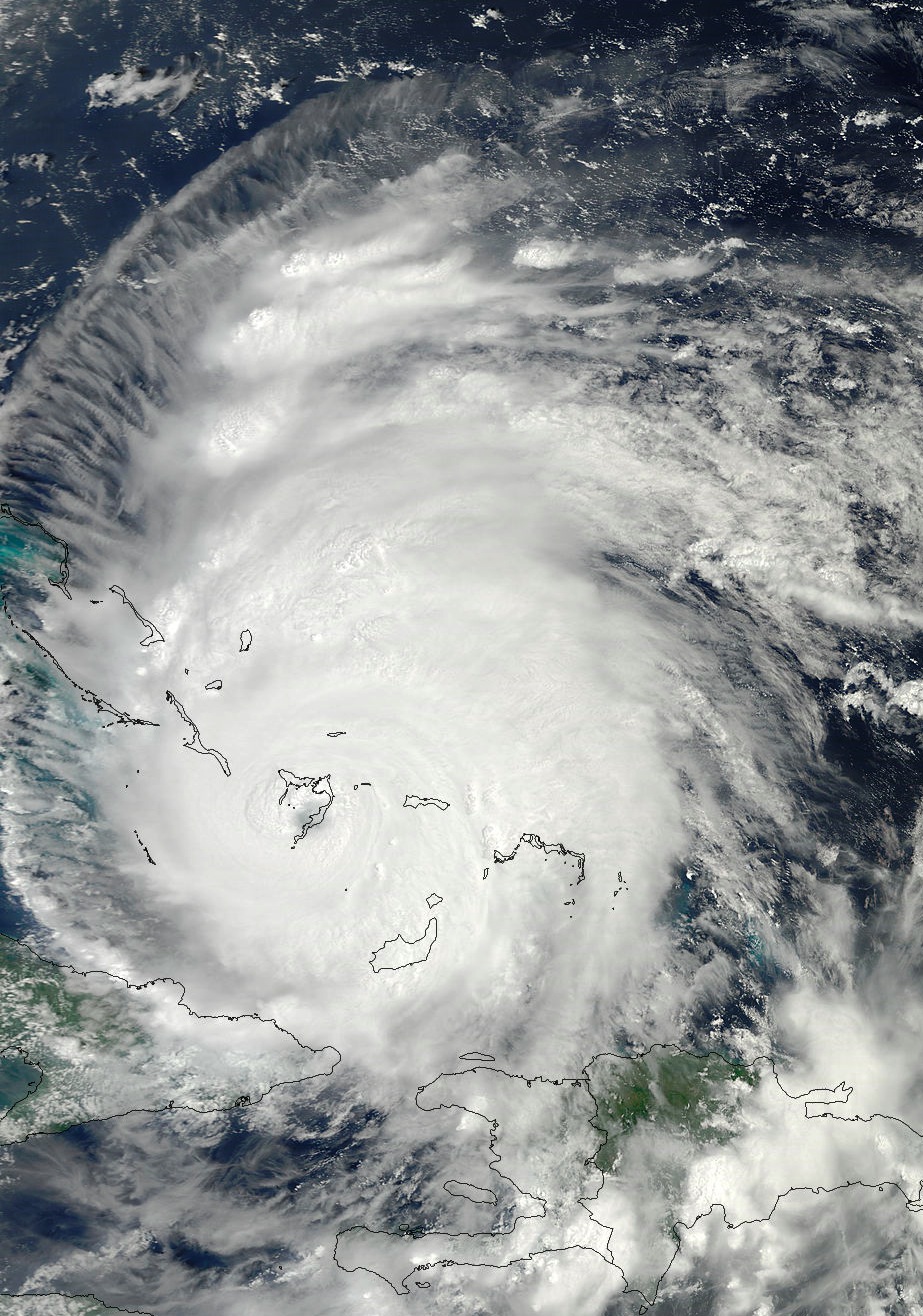
Uncropped (1km resolution):
http://lance-modis.eosdis.nasa.gov/cgi-bin/imagery/single.cgi?image=Irene.A2011236.1505.1km.jpg
Larger (500m resolution):
http://lance-modis.eosdis.nasa.gov/cgi-bin/imagery/single.cgi?image=Irene.A2011236.1505.500m.jpg
Much larger (250m resolution):
http://lance-modis.eosdis.nasa.gov/cgi-bin/imagery/single.cgi?image=Irene.A2011236.1505.250m.jpg
| StrmTrckrMiami |
| (Weather Guru) |
| Wed Aug 24 2011 09:20 PM |

|
|
|
I've noticed that they did make a few changes.
Originally the track had Maine in the "H" reading meaning it would be a cat 1 hurricane when she hit their area. Now it only has Mass and the lower portion of NH in the "H" reading, and Maine is a TS Status. Any clue on what New England should expect for this? I think a major concern here would be flooding, and worry a repeat of the 2006 floods may occur.
| ralphfl |
| (Weather Master) |
| Wed Aug 24 2011 09:23 PM |
|
|
someone asked for this site http://moe.met.fsu.edu/tcgengifs/
| Random Chaos |
| (Weather Analyst) |
| Wed Aug 24 2011 09:28 PM |
|
|
|
|
That change in Maine probably has more to do with the points being 24 hour points but only 6 hours having passed since the last graphic, than any change in intensity.
| StrmTrckrMiami |
| (Weather Guru) |
| Wed Aug 24 2011 09:34 PM |
|
|
|
|
Quote:
That change in Maine probably has more to do with the points being 24 hour points but only 6 hours having passed since the last graphic, than any change in intensity.
Makes Sense. Thank you.
| vineyardsaker |
| (Weather Guru) |
| Wed Aug 24 2011 09:47 PM |
|
|
|
|
Quote:
And here is our beauty:
Uncropped (1km resolution):
http://lance-modis.eosdis.nasa.gov/cgi-bin/imagery/single.cgi?image=Irene.A2011236.1505.1km.jpg
Larger (500m resolution):
http://lance-modis.eosdis.nasa.gov/cgi-bin/imagery/single.cgi?image=Irene.A2011236.1505.500m.jpg
Much larger (250m resolution):
http://lance-modis.eosdis.nasa.gov/cgi-bin/imagery/single.cgi?image=Irene.A2011236.1505.250m.jpg
Thank you so much for the links to these absolutely stunning and beautiful pics!
| cieldumort |
| (Moderator) |
| Wed Aug 24 2011 09:53 PM |

|
|
|
Quote:
Originally the track had Maine in the "H" reading meaning it would be a cat 1 hurricane when she hit their area. Now it only has Mass and the lower portion of NH in the "H" reading, and Maine is a TS Status. Any clue on what New England should expect for this? I think a major concern here would be flooding, and worry a repeat of the 2006 floods may occur.
There are two primary reasons for the change from "H" to "S" over Maine, as follows:
First, the estimated location of the center of Irene during the final period of the 5-Day Cone of Uncertainty from Advisory 18 is now further inland than shown in Advisory 17A , and as such, Irene will have had more time inland weakening, essentially as Random C mentioned above. You can run a historic loop of the graphic Advisories here: http://www.nhc.noaa.gov/archive/2011/graphics/al09/loop_5W.shtml
Second, and related to the first reason, Irene is officially forecast to have turned post-tropical by 2PM Monday. However, it is worth noting that this forecast is largely dependent on Irene being well inland at that time. Should Irene still be partly, largely, or fully over water, it is very possible that she would be more tropical than not, and as such, may still be a hurricane as of Monday afternoon.
As to what New England should expect, it is too early to tell for sure. Tropical Cyclone forecasts beyond 3 days are notoriously off by up to several hundred miles. As during all seasons, it is best to prepare for the worst and expect the best. Irene has the potential to be an epic east coast storm. Potential.
| Random Chaos |
| (Weather Analyst) |
| Wed Aug 24 2011 10:17 PM |
|
|
|
|
Anyone know what is up with the NOAA2 recon? It was heading into the storm when it turned around, and is now back over Florida heading in the general direction of where it took off from.
We still have Air Force AF302 heading in from the east though.
OT: Energy propagation of yesterday's earthquake (click play on the animation)
|
MikeC
|
| (Admin) |
| Wed Aug 24 2011 11:00 PM |
|
|
That usually means mechanical or met equpiment problems, especially with the NOAA planes. But it could be anything really.
Added another satellite recording of Irene. I may record Radar if more gets into view later.
| WesnWylie |
| (Weather Guru) |
| Thu Aug 25 2011 12:03 AM |
|
|
Latest Air Force Recon data is showing that Irene's pressure has dropped to 949.9 mb. I have noticed that Irene's well-defined eye has been slowly fading on satellite. I wonder if she is going to go through another intensification period this evening.
| StrmTrckrMiami |
| (Weather Guru) |
| Thu Aug 25 2011 01:08 AM |
|
|
|
|
Quote:
Latest Air Force Recon data is showing that Irene's pressure has dropped to 949.9 mb. I have noticed that Irene's well-defined eye has been slowly fading on satellite. I wonder if she is going to go through another intensification period this evening.
I had a link somewhere but can not find the Recon data/stats anywhere... do you have a link?
| cguhr3 |
| (Registered User) |
| Thu Aug 25 2011 01:10 AM |
|
|
Looking at a single source .. unysis... a jog to the west is possible @ mid atlantic region... your thoughts?
|
MikeC
|
| (Admin) |
| Thu Aug 25 2011 01:24 AM |
|
|
I assume the European (EMCWF) model, that clips North Carolina bends back Irene westward and takes Irene through Delmarva, and up near Wildwood, NJ. That is a change from earlier runs (a bit to the west), which implies more threat to the Northeast. I do know that the NWS is expanding the release of weather balloons westward to help determine the strength of the trough in ridge in the northeast that may kick the system back west when it gets north of North Carolina.
Those in the Outer Banks of North Carolina, Hampton Roads/Virginia Beach, VA, Delmarva, Jersey Shore, NYC, Long Island, RI, MA, NH, and Maine will want to watch Irene Closely.
It's still too early to say that far away. I will say... watch the NHC's 11PM track tonight.
I fixed the link to the Abaco Rocky Bay cam on the front page, and also the RSS storm feed.
| DougBaker |
| (Verified CFHC User) |
| Thu Aug 25 2011 01:26 AM |
|
|
The 2nd fleet at Norfolk, va is preparing to leave in advance of Irene
http://www.digtriad.com/news/national/ar...Are-Set-To-Move
| watchinout |
| (Verified CFHC User) |
| Thu Aug 25 2011 01:57 AM |
|
|
Just noticed that as of the 8pm update the potential track stated by BAMS has shifted farther west, nearly brings the storm into cape canaveral before turning sharp east and heading for open water. Now I know that every other model is saying its not going to come this close to FL but if you look at the past track of Irene the BAMS has been the most consistent for atleast 2/3's of the past track. What is everyones thoughts?
| cguhr3 |
| (Registered User) |
| Thu Aug 25 2011 02:01 AM |
|
|
thank you... will keep watching!
| GuppieGrouper |
| (Weather Master) |
| Thu Aug 25 2011 02:05 AM |
|
|
Quote:
Just noticed that as of the 8pm update the potential track stated by BAMS has shifted farther west, nearly brings the storm into cape canaveral before turning sharp east and heading for open water. Now I know that every other model is saying its not going to come this close to FL but if you look at the past track of Irene the BAMS has been the most consistent for atleast 2/3's of the past track. What is everyones thoughts?
I will refer you to Ed 's blog on the front page right hand side of screen. He lays out the NHC positions and forecasts. Anything could happen but, the NHC knows its business well enough to keep us informed for up to 3 days in advance of a landfall. I refer you to the forecasting lounge to discuss alternate theories regarding movements of the storm.
|
MikeC
|
| (Admin) |
| Thu Aug 25 2011 02:06 AM |
|
|
Quote:
Just noticed that as of the 8pm update the potential track stated by BAMS has shifted farther west, nearly brings the storm into cape canaveral before turning sharp east and heading for open water. Now I know that every other model is saying its not going to come this close to FL but if you look at the past track of Irene the BAMS has been the most consistent for atleast 2/3's of the past track. What is everyones thoughts?
Model discussion really belongs in the forecast lounge, but the BAMM has actually done horrible with Irene (see the history animatios). It tends to do better with weak near systems and not hurricanes. It can be fairly safely be ruled out.
| Sheeper |
| (Weather Hobbyist) |
| Thu Aug 25 2011 02:25 AM |

|
|
|
reports i have from the Bahamas are of significant damage. 25 foot waves. numerous buildings destroyed on several of the islands. And more to come. Communications is very, very spotty so no details yet.
One of our partner teams (a humanitarian group based here in florida) is currently staging to send relief teams out as soon as its safe.
| Random Chaos |
| (Weather Analyst) |
| Thu Aug 25 2011 02:26 AM |
|
|
|
|
In addition to the ECMWF, I see the 18Z GFDL and 18Z HWRF have both shifted westward (North Carolina / Delmarva / New Jersey). Still too far out for anything definite, though. Tomorrow we should have a much better handle on potential landfall points.
Also noting that the last two vortex recons have noted a concentric eyewall structure.
| cguhr3 |
| (Registered User) |
| Thu Aug 25 2011 02:27 AM |
|
|
sorry.. new to this... did not intend to create an issue.
| StrmTrckrMiami |
| (Weather Guru) |
| Thu Aug 25 2011 03:04 AM |
|
|
|
|
000
WTNT34 KNHC 250255
TCPAT4
BULLETIN
HURRICANE IRENE ADVISORY NUMBER 19
NWS NATIONAL HURRICANE CENTER MIAMI FL AL092011
1100 PM EDT WED AUG 24 2011
...HURRICANE IRENE DANGEROUSLY APPROACHING THE NORTHWESTERN
BAHAMAS...
SUMMARY OF 1100 PM EDT...0300 UTC...INFORMATION
-----------------------------------------------
LOCATION...23.8N 75.4W
ABOUT 790 MI...1270 KM S OF CAPE HATTERAS NORTH CAROLINA
ABOUT 150 MI...245 KM ESE OF NASSAU
MAXIMUM SUSTAINED WINDS...120 MPH...195 KM/H
PRESENT MOVEMENT...NW OR 315 DEGREES AT 12 MPH...19 KM/H
MINIMUM CENTRAL PRESSURE...952 MB...28.11 INCHES
WATCHES AND WARNINGS
--------------------
CHANGES IN WATCHES AND WARNINGS WITH THIS ADVISORY...
NONE
SUMMARY OF WATCHES AND WARNINGS IN EFFECT...
A HURRICANE WARNING IS IN EFFECT FOR...
* THE SOUTHEASTERN...CENTRAL...AND NORTHWESTERN BAHAMAS
INTERESTS FROM THE CAROLINAS NORTHWARD THROUGH NEW ENGLAND SHOULD
MONITOR THE PROGRESS OF IRENE. HURRICANE AND TROPICAL STORM WATCHES
WILL LIKELY BE REQUIRED FOR PORTIONS OF THE COAST OF THE CAROLINAS
EARLY THURSDAY.
FOR STORM INFORMATION SPECIFIC TO YOUR AREA IN THE UNITED
STATES...INCLUDING POSSIBLE INLAND WATCHES AND WARNINGS...PLEASE
MONITOR PRODUCTS ISSUED BY YOUR LOCAL NATIONAL WEATHER SERVICE
FORECAST OFFICE. FOR STORM INFORMATION SPECIFIC TO YOUR AREA OUTSIDE
THE UNITED STATES...PLEASE MONITOR PRODUCTS ISSUED BY YOUR NATIONAL
METEOROLOGICAL SERVICE.
DISCUSSION AND 48-HOUR OUTLOOK
------------------------------
AT 1100 PM EDT...0300 UTC...THE EYE OF HURRICANE IRENE WAS
LOCATED NEAR LATITUDE 23.8 NORTH...LONGITUDE 75.4 WEST. IRENE IS
MOVING TOWARD THE NORTHWEST NEAR 12 MPH...19 KM/H. A TURN TOWARD
THE NORTH-NORTHWEST AND THEN TOWARD THE NORTH ARE EXPECTED ON
THURSDAY. ON THE FORECAST TRACK...THE CORE OF IRENE WILL CONTINUE
TO MOVE ACROSS THE CENTRAL BAHAMAS DURING THE NEXT SEVERAL HOURS
AND MOVE OVER THE NORTHWESTERN BAHAMAS ON THURSDAY.
MAXIMUM SUSTAINED WINDS REMAIN NEAR 120 MPH...195 KM/H...WITH HIGHER
GUSTS. IRENE IS A CATEGORY THREE HURRICANE ON THE SAFFIR-SIMPSON
HURRICANE WIND SCALE. SOME FLUCTUATIONS IN INTENSITY ARE LIKELY
DURING THE NEXT SEVERAL HOURS...BUT SOME STRENGTHENING IS FORECAST
DURING THE NEXT DAY OR SO. IRENE COULD BECOME A CATEGORY FOUR
HURRICANE ON THURSDAY.
IRENE IS A LARGE TROPICAL CYCLONE. HURRICANE FORCE WINDS EXTEND
OUTWARD UP TO 70 MILES...110 KM...FROM THE CENTER...AND TROPICAL
STORM FORCE WINDS EXTEND OUTWARD UP TO 255 MILES...410 KM.
A RECONNAISSANCE PLANE ESTIMATED A MINIMUM CENTRAL PRESSURE OF 952
MB...28.11 INCHES.
HAZARDS AFFECTING LAND
----------------------
WIND...HURRICANE FORCE WINDS ARE STILL OCCURRING OVER PORTIONS OF
THE SOUTHEASTERN AND THE CENTRAL BAHAMAS. WINDS SHOULD GRADUALLY
BEGIN TO INCREASE IN THE NORTHWESTERN BAHAMAS...REACHING HURRICANE
FORCE BY THURSDAY.
STORM SURGE...IN AREAS OF ONSHORE WINDS NEAR THE CENTER OF IRENE...
AN EXTREMELY DANGEROUS STORM SURGE WILL RAISE WATER LEVELS BY AS
MUCH AS 7 TO 11 FEET ABOVE NORMAL TIDE LEVELS OVER THE BAHAMAS.
NEAR THE COAST...THE SURGE WILL BE ACCOMPANIED BY LARGE AND
DANGEROUS WAVES.
RAINFALL...IRENE IS EXPECTED TO PRODUCE RAINFALL ACCUMULATIONS OF 6
TO 12 INCHES OVER THE BAHAMAS DURING THE NEXT 36 HOURS. RAINS WILL
BE DIMINISHING ACROSS THE TURKS AND CAICOS ISLANDS WITH ADDITIONAL
RAINFALL AMOUNTS OF 1 TO 3 INCHES POSSIBLE...BRINGING THE MAXIMUM
STORM TOTAL TO 6 TO 12 INCHES.
SURF...SWELLS GENERATED BY IRENE WILL BEGIN AFFECTING PORTIONS OF
THE COAST OF THE SOUTHEASTERN UNITED STATES ON THURSDAY. THESE
SWELLS ARE EXPECTED TO CAUSE LIFE-THREATENING SURF AND RIP CURRENT
CONDITIONS. PLEASE CONSULT PRODUCTS FROM YOUR LOCAL NATIONAL
WEATHER SERVICE FORECAST OFFICE.
NEXT ADVISORY
-------------
NEXT INTERMEDIATE ADVISORY...200 AM EDT.
NEXT COMPLETE ADVISORY...500 AM EDT.
$$
FORECASTER AVILA
| Random Chaos |
| (Weather Analyst) |
| Thu Aug 25 2011 03:23 AM |
|
|
|
|
No longer concentric eyewalls:
Product: Air Force Vortex Message (URNT12 KNHC)
Transmitted: 25th day of the month at 03:19Z
Aircraft: Air Force Aircraft (Last 3 digits of the tail number are 302)
Storm Number & Year: 09L in 2011
Storm Name: Irene (flight in the North Atlantic basin)
Mission Number: 17
Observation Number: 16
A. Time of Center Fix: 25th day of the month at 3:07:20Z
B. Center Fix Coordinates: 23°50'N 75°35'W (23.8333N 75.5833W)
B. Center Fix Location: 140 miles (225 km) to the SE (128°) from Nassau, Bahamas.
C. Minimum Height at Standard Level: 2,685m (8,809ft) at 700mb
D. Estimated (by SFMR or visually) Maximum Surface Wind: 71kts (~ 81.7mph)
E. Location of the Estimated Maximum Surface Wind: 22 nautical miles (25 statute miles) to the WNW (292°) of center fix
F. Maximum Flight Level Wind Inbound: From 45° at 90kts (From the NE at ~ 103.6mph)
G. Location of Maximum Flight Level Wind Inbound: 28 nautical miles (32 statute miles) to the WNW (296°) of center fix
H. Minimum Sea Level Pressure: 953mb (28.14 inHg)
I. Maximum Flight Level Temp & Pressure Altitude Outside Eye: 8°C (46°F) at a pressure alt. of 3,048m (10,000ft)
J. Maximum Flight Level Temp & Pressure Altitude Inside Eye: 16°C (61°F) at a pressure alt. of 3,045m (9,990ft)
K. Dewpoint Temp (collected at same location as temp inside eye): 13°C (55°F)
K. Sea Surface Temp (collected at same location as temp inside eye): Not Available
L. Eye Character: Open in the west
M. Eye Shape & Diameter: Circular with a diameter of 8 nautical miles
N. Fix Determined By: Penetration, Radar, Wind, Pressure and Temperature
N. Fix Level: 700mb
O. Navigation Fix Accuracy: 0.02 nautical miles
O. Meteorological Accuracy: 0.1 nautical miles
Remarks Section:
Maximum Flight Level Wind: 99kts (~ 113.9mph) in the northeast quadrant at 1:41:00Z
Maximum Flight Level Temp: 16°C (61°F) which was observed 10 nautical miles (12 statute miles) to the W/WNW (281°) from the flight level center
|
MikeC
|
| (Admin) |
| Thu Aug 25 2011 03:47 AM |
|
|
I turned on long term recording of the miami long range radar, you can see one of Irene's rainbands on the far east in the Bahamas now.
Long Term Long Range US Radar of Irene