| Random Chaos |
| (Weather Analyst) |
| Sun Aug 14 2011 12:35 AM |

|
|
|
Looking at our four systems in the Atlantic (Franklin remnants, TD7, 92L SE of Bermuda, and 93L Mid-Atlantic):
Franklin remnants: Transitioned to an extratropical storm, well out to sea, being ripped apart, and not looking to ever effect land even as a remnant.
Tropical Depression 7: NHC takes it passing near Bermuda, but strength wise it does not show any sign of becoming anything major. Most likely will pass Bermuda as a Tropical Storm, may strengthen a fraction more after that before transitioning to extratropical and following Franklin out to sea. No effect to anything but Bermuda, and that is minimal given it's lack of being a wind event.
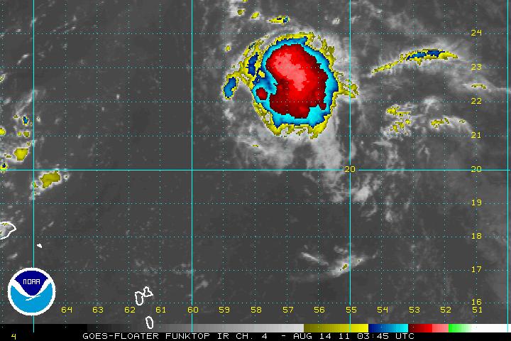
92L: Actually looks almost better on IR than TD7 does. Somewhat surprised that NHC is giving it only a 30% chance of development. It has already developed a very deep CDO and is taking on a slight comma-like appearance. Vorticity models show plenty of spin around it, too. However, even if it should become our next Atlantic storm, like Franklin and TD7, it should be staying well out to sea with only a possible effect on Bermuda.

(92L Funktop IR satellite view)
93L: This system is mid-atlantic, looks pretty weak at present. Not a lot of convection, fair amount of SAL to its north affecting it, but not in line with it's path. Models show little chance of development over the short term, but this system bears much more long term watching. Vorticity models show that the spin will stay intact for an extended period of time as it heads westward, and with no development, there is nothing to pull the system north. I would keep an eye on this system for possible development in a few days. To me, this system bears the most watching since it is the only one of the four systems that might not spin fish, should it develop.
Ref:
Cyclone Phase - http://moe.met.fsu.edu/cyclonephase/
GFS Models - http://moe.met.fsu.edu/tcgengifs/
SAL - http://tropic.ssec.wisc.edu/
IR / WV - http://www.ssd.noaa.gov/PS/TROP/trop-atl.html