| cieldumort |
| (Moderator) |
| Mon Aug 28 2023 05:29 AM |

|
|
|
1:15PM EDT 30 August 2023 Update
A fortuitously timed Eyewall Replacement Cycle began as Idalia made landfall, weakening the hurricane, and thus lowering the maximum sustained winds. Nonetheless, severe impacts were and still are widely felt.
As of this update, Idalia continues pushing inland, analyzed by NHC as a Cat 1. The center is clearly located east of Valdosta, GA.
NHC is now ending hourly advisories. The next intermediate advisory will be issued at 2:00 PM EDT.
9:00PM EDT 29 August 2023 Update
Idalia is continuing to rapidly intensify. Interests along the west and northwest Florida coast, especially those in Surge Warning and Hurricane Warning areas should now be rushing any last minute preps to protect life and property to completion. Impacts will also be felt well inland. Power outages may last days or even weeks. Hazards such as felled and falilng trees, roof and even building failures, rapidly rising water, could soon make passage to safety difficult and potentially deadly in your area.
1:30PM EDT 29 August 2023 Update
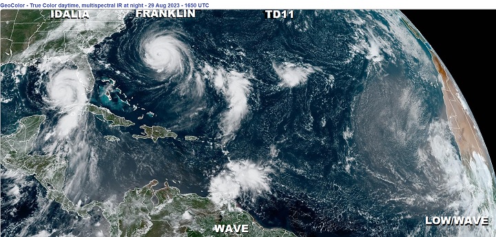
This wide view of the Tropical Atlantic really highlights how much larger Hurricane Idalia has become. While the cyclone has a well-defined and tight inner core with an increasingly healthy eyewall, the reach of Idalia's winds and heavy rains extends out up to hundreds of miles from the center. This not only will prolong the wind and rain over many locations, but also dramatically increase the fetch of storm surge. Deadly storm surge.
This image is also a reminder that the entire basin is still favorable for development, with two more Tropical Cyclones being tracked (Franklin and T.D. 11), as well as two other areas of interest.
Original Update
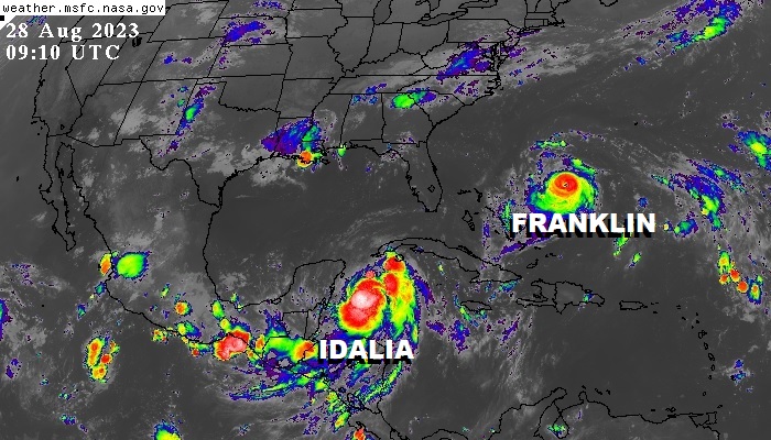
Overnight, Hurricane Franklin became the first Major Hurricane of the 2023 Atlantic Hurricane Season, and as of the 4AM CT NHC Advisory, Hurricane Idalia is now officially forecast to become a Major Hurricane as well.
The time for Floridians to prepare for potentially life-threatening storm surge, wind and rain is today. By Tuesday conditions (and not just the weather) may start to become far too difficult for many.
Models are ingesting flight after flight of recon data now, and this should assist forecasters. We go into them in greater detail in the Idalia Forecast Lounge , which is also a good place to discuss pure informed speculation and best guesses as to Idalia's future.
Social Media: Follow us on Facebook
Tropical Storm Idalia Local Statement Advisory Number 7
National Weather Service Tallahassee FL AL102023
515 AM EDT Mon Aug 28 2023 /415 AM CDT Mon Aug 28 2023/
This product covers eastern Florida panhandle, Florida Big Bend, southeastern Alabama and southwestern Georgia
Quote:
...IDALIA NOW FORECAST TO BECOME A MAJOR HURRICANE BEFORE LANDFALL...
...POTENTIAL IMPACTS...
-----------------
* SURGE:
Prepare for life-threatening surge having possible devastating impacts across Taylor and Dixie Counties. Potential impacts in this area include:
- Widespread deep inundation, with storm surge flooding greatly accentuated by powerful battering waves. Structural damage to buildings, with many washing away. Damage greatly compounded from considerable floating debris. Locations may be uninhabitable for an extended period.
- Near-shore escape routes and secondary roads washed out or severely flooded. Flood control systems and barriers may become stressed.
- Extreme beach erosion. New shoreline cuts possible.
- Massive damage to marinas, docks, boardwalks, and piers. Numerous small craft broken away from moorings with many lifted onshore and stranded.
Also, prepare for life-threatening surge having possible significant to extensive impacts across Wakulla and Jefferson Counties.
Also, prepare for locally hazardous surge having possible limited impacts across Franklin and Gulf Counties.
Elsewhere across eastern Florida panhandle, Florida Big Bend, southeastern Alabama and southwestern Georgia, little to no impact is anticipated.
* WIND:
Prepare for life-threatening wind having possible devastating impacts across coastal Taylor and Dixie Counties. Potential impacts in this area include:
- Structural damage to sturdy buildings, some with complete roof and wall failures. Complete destruction of mobile homes. Damage greatly accentuated by large airborne projectiles. Locations may be uninhabitable for weeks or months.
- Numerous large trees snapped or uprooted along with fences and roadway signs blown over.
- Many roads impassable from large debris, and more within urban or heavily wooded places. Many bridges, causeways, and access routes impassable.
- Widespread power and communications outages.
Also, prepare for life-threatening wind having possible limited to extensive impacts across the remainder of the Florida Big Bend.
* FLOODING RAIN:
Prepare for life-threatening rainfall flooding having possible extensive impacts in the far eastern Big Bend and Suwannee Valley. Potential impacts include:
- Major rainfall flooding may prompt many evacuations and rescues.
- Rivers and tributaries may rapidly overflow their banks in multiple places. Small streams, creeks, and ditches may become dangerous rivers. Flood control systems and barriers may become stressed.
- Flood waters can enter many structures within multiple communities, some structures becoming uninhabitable or washed away. Many places where flood waters may cover escape routes. Streets and parking lots become rivers of moving water with underpasses submerged. Driving conditions become dangerous. Many road and bridge closures with some weakened or washed out.
Prepare for dangerous rainfall flooding having possible limited to significant impacts across southeast Alabama, southwest and south central Georgia, and the Florida Panhandle and western Big Bend.
* TORNADOES:
Prepare for a dangerous tornado event having possible significant impacts across the southeast Big Bend. Potential impacts include:
- The occurrence of scattered tornadoes can hinder the execution of emergency plans during tropical events.
- Several places may experience tornado damage with a few spots of considerable damage, power loss, and communications failures.
- Locations could realize roofs torn off frame houses, mobile homes demolished, boxcars overturned, large trees snapped or uprooted, vehicles tumbled, and small boats tossed about. Dangerous projectiles can add to the toll.
Prepare for a tornado event having possible limited impacts across the eastern and coastal Big Bend and Lowndes and Lanier Counties in Georgia.
Elsewhere across eastern Florida panhandle, Florida Big Bend, southeastern Alabama and southwestern Georgia, little to no impact is anticipated.
PRECAUTIONARY/PREPAREDNESS ACTIONS
----------------------------------
* EVACUATIONS:
Listen to local official for recommended preparedness actions, including possible evacuation. If ordered to evacuate, do so immediately.
For those not under evacuation orders, assess the risk from wind, falling trees, and flooding at your location. If you decide to move, relocate to a safer location nearby. If you do not relocate, help keep roadways open for those under evacuation orders.
If evacuating, leave with a destination in mind and allow extra time to get there. Take your emergency supplies kit. Gas up your vehicle ahead of time.
* OTHER PREPAREDNESS INFORMATION:
Now is the time to check your emergency plan and emergency supplies kit and take necessary actions to protect your family and secure your home or business.
SUMMARY OF WATCHES AND WARNINGS IN EFFECT:
A Hurricane Warning is in effect for...
* Pinar del Rio Cuba
A Tropical Storm Warning is in effect for...
* Yucatan Peninsula from Tulum to Rio Lagartos, including Cozumel
* Isle of Youth Cuba
* Dry Tortugas Florida
A Storm Surge Watch is in effect for...
* Chokoloskee to Indian Pass Florida, including Tampa Bay
A Hurricane Watch is in effect for...
* Englewood to Indian Pass Florida, including Tampa Bay
A Tropical Storm Watch is in effect for...
* South of Englewood to Chokoloskee Florida
* Lower Florida Keys west of the west end of the Seven Mile Bridge
{{StormLinks|Idalia|10|10|2023|10|Idalia}}
{{StormLinks|Franklin|08|8|2023|08|Franklin}}
{{StormLinks|TD#11|11|11|2023|11|Tropical Depression Eleven}}
{{TampaMedia}}
{{PanhandleMedia}}
{{SWFloridaMedia}}
{{NortheastGulfRadar}}
{{BermudaNews}}