| cieldumort |
| (Moderator) |
| Thu Aug 22 2024 09:04 PM |

|
|
|
9:15PM HST 24 August 2024 (3:15AM EST 25 August 2024) Update
Special Advisory products could be coming soon (Hurricane Hone)
7:50PM HST 24 August 2024 Update
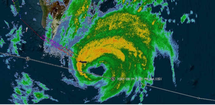
Hone looks to be on a strengthening run as well as tracking a touch north of forecast heading towards impact on the Big Island. Tropical Storm conditions have begun, and preps to protect life and property should be taken seriously and moved to completion. Recon is back in Hone now and will give a much clearer picture of the cyclone's intensity and prospects, but so far, infrared satellite as well as radar, including velocity, suggests a potential for a hurricane prior to passage.
5:00PM HST/11:00PM EDT 23 August 2024 Update
A Tropical Storm Warning is now in effect for Hawaii County
NHC
Quote:
At 500 PM HST (0300 UTC), the center of Tropical Storm Hone was located near latitude 16.9 North, longitude 149.3 West. Hone is moving toward the west near 16 mph (26 km/h). This motion toward the west is expected to continue over the next several days as the forward speed gradually slows. On the forecast track, the center of Hone is expected to pass near or south of the Big Island Saturday night into early Sunday.
Maximum sustained winds are near 50 mph (85 km/h) with higher gusts. Strengthening is forecast during the next 48 hours, and may become a hurricane by Sunday, followed by weakening late Sunday and beyond.
Tropical-storm-force winds extend outward up to 115 miles (185 km) from the center.
1:00AM EDT 23 August 2024 Update
A Tropical Storm Watch has been issued for the Big Island of Hawaii.
Quote:
HAZARDS AFFECTING LAND
WIND: Tropical storm conditions are possible in the watch area later Saturday into Sunday. Winds are expected to be strongest where they blow downslope from higher terrain, over headlands, and through passes.
RAINFALL: Hone is expected to produce storm total rainfall of 4 to 8 inches over mainly windward and southeast facing slopes of the Big Island, with locally higher amounts. Rainfall totals of 2 to 4 inches will be possible over portions of the smaller islands, mainly windward.
SURF: Swells generated by Tropical Storm Hone are expected to begin reaching the Hawaiian Islands over the weekend. These swells are likely to cause life-threatening surf and rip currents.
Original Update
In a very unusual and almost completely unexpected turn of events, Hawaii is under threat, while Atlantic-side islands and coastal lands including other US states and territories are still almost completely free of imminent tropical concern during the final days of August.
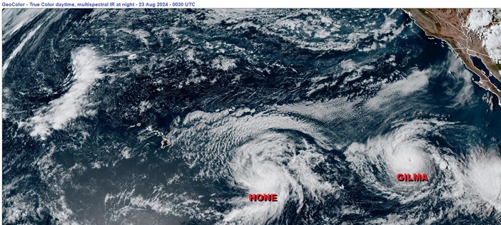
Today, Tropical Storm Hone has formed from Tropical Depression One in the central Pacific. Models increasingly put Hawaii in the potential track of even a direct strike from this system. In addition, behind Hone, now Major Hurricane Gilma in the eastern Pacific could follow.
We do not list Pacific tropical cyclones in the bar under "Current Storms," but we do have Forecast Lounges already up and will continue to update the main page, Lounges and social media sites given the genuine risk to the Hawaiian islands. These are islands not accustomed to impacts from even "weak" tropical storms, with hills and mountains potentially squeezing out far more rainfall than what might typically fall, all while creating pathways for dangerous floods and mudslides. Additionally, higher elevations could experience much stronger gusty winds, while dangerous surf and rip currents affect the shoreline.
A Tropical Storm Watch may be issued for portions of the main Hawaiian Islands by Friday.
Tropical Storm Hone Forecast Lounge
Hurricane Gilma Forecast Lounge