| cieldumort |
| (Moderator) |
| Tue Sep 16 2025 08:49 AM |

|
|
|
18AM EDT 26 September 2025 Update
Humberto is now a hurricane this morning and Bermuda is in the cone, however it is likely to stay west of Bermuda, although those there should keep an eye on it.
Invest 94L still has a 80/90% chance to develop, high level steering recon is out en force today, but the first low level standard one happens this afternoon. Advisories may start at any time today on this system. There still is quite a bit of uncertainty in regards to the track and intensity of 94L going forward because of how close Humberto is, but those along the southeast, particularly in South Carolina and North Carolina need to pay close attention.
12:30PM EDT 25 September 2025 Update
It is increasingly likely that NHC Advisories will begin on what should ultimately become Imelda, whether or not a TC has yet formed. This is because models are now strongly advertising development with impacts on land (Bahamas, specifically) within the next 72 hours. In fact, tropical storm conditions could arrive within just the next 48 hours. Interests in the Bahamas may already want to be making initial preparations for the arrival of tropical cyclone conditions over the weekend that could continue into early next week.
Updated Issuance Criteria for Potential Tropical Cyclone Advisory
Quote:
The National Hurricane Center (NHC), the Central Pacific Hurricane Center (CPHC), and the National Weather Service (NWS) have updated the issuance criteria for tropical cyclone advisory products for Potential Tropical Cyclones. A Potential Tropical Cyclone (PTC) is a disturbance that is not yet a tropical cyclone but poses the threat of bringing tropical storm or hurricane conditions to land areas. With the change, the NHC and CPHC will have the ability to issue tropical cyclone advisory products up to 72 hours before the anticipated arrival of storm surge or tropical-storm-force winds on land regardless of the immediate need for land-based tropical storm, hurricane, or storm surge watches or warnings. Previously, NHC and CPHC could only begin issuing advisory products for PTCs that required land-based watches (issued 48 hours in advance of conditions beginning) or warnings (issued 36 hours in advance of conditions beginning). This change gives NHC and CPHC the option to issue these advisory products at longer lead times when confidence is high that there is a significant risk of wind and storm surge impacts to land areas. Tropical cyclone advisory products for PTCs include all storm-specific text and graphical products routinely issued by NHC and CPHC each advisory cycle (i.e., 0300, 0900, 1500, and 2100 Coordinated Universal Time (UTC)), such as the Tropical Cyclone Public Advisory (TCP) and the Cone Graphic.
Ciel
8:00AM EDT 25 September 2025 Update
Invest 93L became Tropical Storm Humberto yesterday and is now officially forecast to become a Major by Monday. Interests in Bermuda may want to watch it closely, as while presently outside of the cone, NHC track error margins this far out can be significant.
Invest 94L now has NHC 90% chances of developing this week and 70% within just the next 48 hours. Models strongly suggest that the US could be in play. This disturbance bears very close watching for everyone from the Bahamas up through Florida and the entire southeast. Advisories could be coming soon even if a depression has not yet formed. Recon is aggressively flying and sampling the environment in and around 94L, and this invaluable data will help improve the forecasts going forward.
Way out in the northeastern subtropical Atlantic, a wind max associated with Hurricane Gabrielle could really do a number on the Azores overnight tonight into Friday, and interests there should be rushing preparations to completion for a very strong Cat 1 hurricane that could come in causing more damage than that of a typical Cat 1.
The concerns about a potentially active back half of the season are verifying.
Ciel
9:30PM EDT 23 September 2025 Update
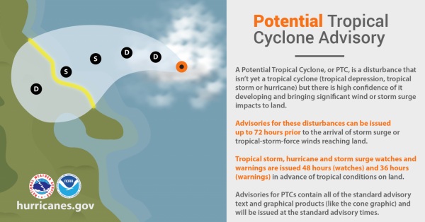
Conditions for development of both Invests 93L and 94L continue improving, and given their close proximity to land and the updated 2025 NHC policy allowing advisories to be issued on Potential Tropical Cyclones, "PTCs," up to 72 hours before the anticipated arrival of storm surge or tropical-storm-force winds on land whether or not a bona fide TC has yet formed, official NHC advisories, possibly even watches and/or warnings, could be coming within the next 24 hours, even as quickly as by tomorrow morning.
Forecasting the tracks and intensities of both Invest 93L and 94L is very challenging, even for the best computer models and most seasoned hurricane experts. More competing and interacting influences than normal, not the least of which could be their proximity to one another, will likely result in any initial forecasts and advisories being of lower confidence than usual.
More than a half dozen recon flights have already been scheduled for 94L, which is the disturbance closest to land. Flights will almost certainly get added soon for 93L, as well.
Ciel
12:00PM EDT 23 September 2025 Update
A Hurricane Watch is now in place for all of the Azores in the northeastern Subtropical Atlantic with Gabrielle. Strong Cat 1/2 hurricane conditions are increasingly likely across the islands late Thursday into early Friday. Interests in the Azores islands should begin taking hurricane preparations as conditions are forecast to deteriorate rapidly within the next 48 hours.
Soon after passing through the Azores, strong post-tropical/hybrid storm conditions are increasingly possible in Spain and Portugal over the coming weekend into Monday with damaging winds and heavy surf.
Much closer to home, model runs continue heating up on newly Invest-tagged 93L and 94L, with a few notable exceptions. Conditions for development in the Atlantic basin are orders of magnitude improved over just a few weeks ago and it would not be surprising to see both get named. The next names on the list in the Atlantic this year are Humberto and Imelda.
Deeper model dives and speculation on all three of these can be found in the Forecast Lounge Forum:
Invest 93L Forecast Lounge
Invest 94L Forecast Lounge
Hurricane Gabrielle Forecast Lounge
Quote:
The Azores Meteorological Service has issued a Hurricane Watch for all the islands of the Azores.
SUMMARY OF WATCHES AND WARNINGS IN EFFECT:
A Hurricane Watch is in effect for ... All of the Azores
Ciel
1:00PM EDT 22 September 2025 Update
Gabrielle became our second Major of the year while comfortably southeast of Bermuda.
Recon missions are presently sampling the very well-developed hurricane and finding that an eyewall replacement cycle could be starting, but for now, weakening has not commenced. Once the ERC has completed, it is possible that the hurricane's windfield is larger, with its upper-bound on the Saffir-Simpson scale a bit restricted as a trade-off. Given the potential for a larger Gabrielle, interests in the Azores may want to begin paying more attention, as hurricane conditions there could occur in less than 72 hours.
Elsewhere, three other areas of interest are on our radar. More on these to come.
Ciel
10:00AM EDT 17 September 2025 Update
Invest 92L became designated TD 7 early this morning. SEVEN is a very sloppy depression, and there may even be an argument that it remains more of a trof than one would like to see in a designated TC.
Initial runs on 92L pegged the disturbance around 13N, with NHC initial positioning of SEVEN at 13.7N. The system tracked as SEVEN now appears to be closer to 19N, based on conventional satellite imagery. Models and forecasts of SEVEN should be taken with a large helping of salt until there is more clarity. "TD 7" could have made a jump into the northern portion of the trof axis.
More on this in the Gabrielle Lounge
Ciel
Original Update
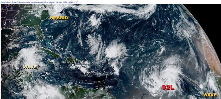
After a peak-season hibernation the likes of which have not been seen since 1939, the Atlantic basin is waking back up.
Basin-wide conditions for development are improving this week. A positive pulse from the MJO along with a climatologically consistent trend towards greater instability overall as we head into fall will conspire to enhance thunderstorm activity. Higher pressure in the subtropics appears set to weaken and/or shove away some of the TUTTs that have imparted high levels of shear and dry air over the past month. Meanwhile, the waves keep rolling off of Africa.
One of the waves to recently exit Africa is now on the cusp of becoming our next TD. This disturbance, Invest 92L, has potential to become a long-track Cape Verde-type storm, provided the basin does perform this week as forecast. Several models give 92L decent odds to become a powerful hurricane. Fortunately, very few models take it towards land, but at a minimum, Bermuda should watch.
Behind 92L another wave appears to have a good shot at development. This one is not yet Invest tagged.
Closer to home, a hybrid coastal storm off the coast of NC/VA remains too attached to its parent fronts and is under too much shear to have much more than maybe a 2% chance at a name, but those right along the coasts in this region probably agree that it "feels" like something with a name. This is expected to weaken today and track out to sea.
{{StormLinks|Gabrielle|07|7|2025|7|Gabrielle}}
{{StormLinks|Humberto|08|8|2025|8|Humberto}}
{{StormLinks|94L|94|9|2025|93|Invest 94L}}
{{SCMedia}}
{{BermudaNews}}