CFHC
|
| () |
| Wed Jun 10 2026 10:50 AM |

|
 Potential Tropical Cyclone One Issued Near Texas Gulf Coast
|
8:30AM CDT 17 June, 2026 Update
PTC ONE is producing sustained winds into tropical storm force based on buoy, ship and oil rig reports. Recon is now flying in. The cyclone at this time resembles a sheared tropical storm and it would not be surprising if we have Arthur at 10AM.
Ciel
4:00AM CDT 17June, 2026 Update
PTC ONE is a highly-sheared cyclone this morning, and too void of convection near and over the center for it to be classified as a Tropical Cyclone. However, with PTC ONE, as has been mentioned here, there and everywhere, the classification isn't what matters, but rather the impacts.
Quote:
Quote:
KEY MESSAGES:
Quote:
Quote:
1. Potentially life-threatening flash flooding and urban flooding are likely through Thursday across southern Louisiana, southern Mississippi, southern Alabama, southwestern Georgia and the Florida Panhandle, with possible flooding near the Upper Texas coast. Ongoing heavy rainfall could prolong the flood threat into the weekend.
Quote:
Quote:
2. Tropical-storm-force winds are expected along the Louisiana coast today from Sabine Pass to Morgan City where a Tropical Storm Warning is in effect.
Quote:
Quote:
3. Minor to moderate coastal flooding is expected along portions of the Upper Texas and Louisiana coastlines today.
Quote:
Quote:
FORECAST POSITIONS AND MAX WINDS
Quote:
Quote:
INIT 17/0900Z 28.0N 96.7W 25 KT 30 MPH...POTENTIAL TROP CYCLONE
Quote:
12H 17/1800Z 29.1N 95.2W 35 KT 40 MPH...TROPICAL STORM
Quote:
24H 18/0600Z 31.1N 92.8W 25 KT 30 MPH...POST-TROP/REMNT LOW
Quote:
36H 18/1800Z...DISSIPATED
Ciel
4:00PM CDT 16 June, 2026 Update
PTC ONE is already on the cusp of being classifiable as a Tropical Depression and may go straight to being a named Tropical Storm within minutes or hours after moving offshore. A Tropical Storm Warning is now up for the coast of Louisiana from Sabine Pass to Morgan City. There are a few models that increasingly suggest likely-Arthur may have a chance to strengthen a little more than forecast, so mariners and those along the coast may want to take note. Additionally, interactions with strong jet dynamics and a very large area of "brown ocean" (very saturated land and a humid atmosphere) could keep likely-Arthur going - perhaps even intensifying - over land. This is a very dangerous storm.
Quote:
NWS National Hurricane Center Miami FL AL012026 400 PM CDT Tue Jun 16 2026 ...DANGEROUS FLASH FLOODING CONTINUES OVER PORTIONS OF TEXAS AND LOUISIANA FROM POTENTIAL TROPICAL CYCLONE ONE.... ...TROPICAL STORM WARNING ISSUED FOR PORTIONS OF THE LOUISIANA COAST.. SUMMARY OF 400 PM CDT...2100 UTC...INFORMATION ----------------------------------------------LOCATION...27.3N 97.6W ABOUT 35 MI...60 KM SSW OF CORPUS CHRISTI TEXAS ABOUT 330 MI...530 KM SW OF LAKE CHARLES LOUISIANA MAXIMUM SUSTAINED WINDS...30 MPH...45 KM/H[ PRESENT MOVEMENT...NE OR 45 DEGREES AT 6 MPH...9 KM/H MINIMUM CENTRAL PRESSURE...1005 MB...29.68 INCHES WATCHES AND WARNINGS--------------------CHANGES WITH THIS ADVISORY:A Tropical Storm Warning is issued for the coast of Louisiana from Sabine Pass to Morgan City. SUMMARY OF WATCHES AND WARNINGS IN EFFECT: A Tropical Storm Warning is in effect for...* Sabine Pass to Morgan Cit A Tropical Storm Watch is in effect for... * Sargent to Sabine Pass
Ciel
9:30AM CDT 16 June, 2026 Update
NHC will initiate advisories on Potential Tropical Cyclone One (formerly AL90) located over southern Texas, at 1000 AM CDT (1500 UTC).
8:00AM CDT 16 June, 2026 Update
Invest 90L is over land and still has a 60% chance to develop. The energy is stretched out along the front, but the best track position has it located there northwest of Brownsville near Encino, TX. This area has a chance to develop once it reaches the water, but anything that does (if it does) is likely to be short lived. The impact remains heavy, flooding rainfall.
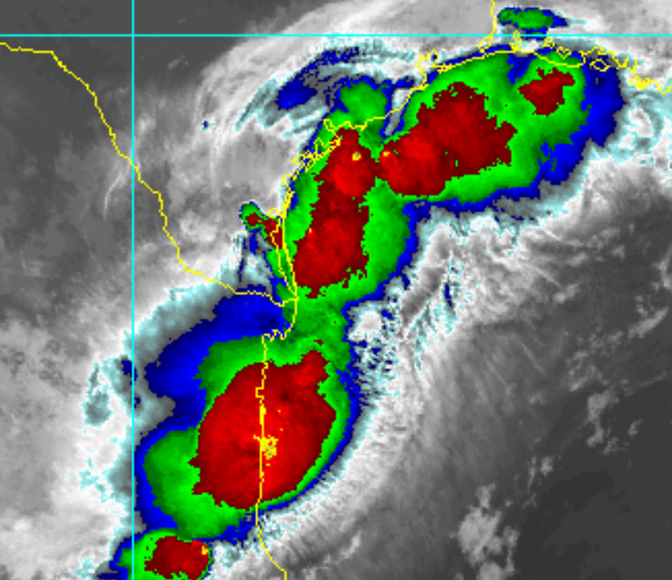
1:40PM CDT 15 June, 2026 Update
The Area of Interest has just been Invest-tagged, 90L. Specialized model runs will begin shortly and recon is being tentatively scheduled.
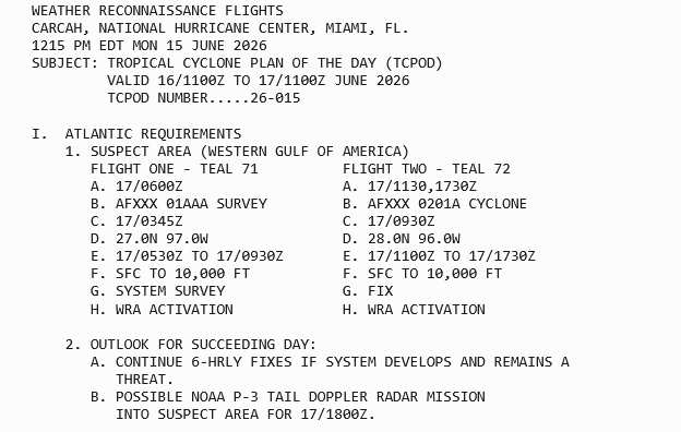
Ciel
1:00PM CDT 15 June, 2026 Update
Chances for development of this system are up to 50%, and Tropical Storm Watches and Warnings could be issued as early as tomorrow for portions of the NW Gulf.
12:00PM CDT 15 June, 2026 Update
Widespread flash flooding, some of it catastrophic, continues. WPC has greatly expanded the MODERATE RISK outline
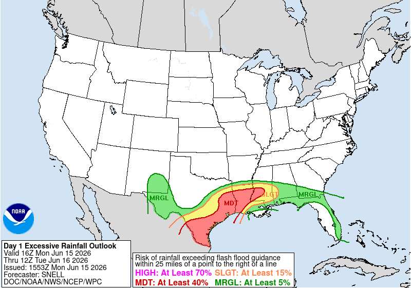
4:45PM CDT 14 June, 2026 Update
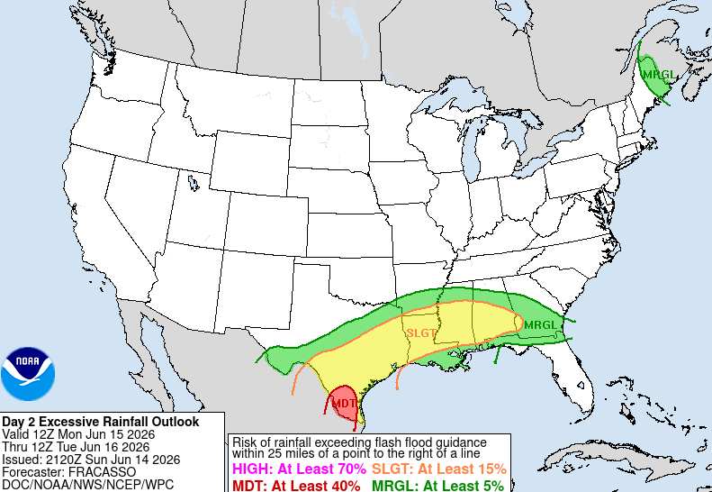
The risk of Flash Flooding across the south is going way up in response to the abundant influx of deep, tropical moisture courtesy of the area of low pressure we have been tracking and which is now inland over northeastern Mexico feeding into and interacting with an approaching wind shift front that is forecast to pull up mostly stationary for several days. Ground will likely become saturated if it isn't already across portions of south Texas, southeast Texas and Louisiana, and a multi-day, life-threatening flood event may be setting up.
Ciel
10:00AM CDT 13 June, 2026 Update
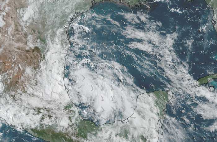
Above: This morning's visible image of the Gulf Low overlaid with GFS-analyzed 10-meter winds cr. TC-ATLAS
The Low in the western Gulf continues to gradually become better organized and is now likely centered just east of Tampico, MX, heading generally NW to NNW. Fluctuations in its path are likely over the next 3-7 days, but it is mostly modeled to head inland and then either track just inland from the coast of Texas, bumping into an approaching front, or reemerge off the coast roughly east of Brownsville, TX early next week.
The greatest risk with the area of low pressure in the western Gulf is going to be from the potential for several days of tropical rainfall and flooding, regardless of whether or not it becomes a Tropical Depression. The same will be true should it become a Tropical Depression, but never get a name. This is a system that is cranking up loads and loads of moisture into eastern Mexico, Texas and Louisiana, is likely to get stuck underneath a stalling front, and then get wrung out over the course of 3-7 days over many of the same areas. Flooding is always a serious risk with 'weak' systems that slow down or stall, but unfortunately, all-too-often these systems do not get the attention they deserve because they lack a name or title.
-Ciel
7:45AM CDT 12 June, 2026 Update
An area of low pressure has indeed formed in the Bay of Campeche. This is a very favorable region for Tropical Cyclogenesis and despite less-than-ideal conditions for development, development is possible and in fact the odds appear to be going up. An Invest tag is likely coming, specialized model runs would be added, and perhaps recon will also be tasked, depending.
-Ciel
Original Update
The 8am update for the tropical weather outlook now has the first area of interest for the 2026 Atlantic Hurricane season. This area would be the remnants of Cristina in the East Pacific after it crosses Guatemala and Mexico, which has a lot of high mountains. It's overall unlikely to develop, but worth watching in those areas and later on in the Gulf side of Mexico, and rainfall could reach its way into Texas after this. It'll be monitored for mid to late next week, but at this time development chances appear to be very low.
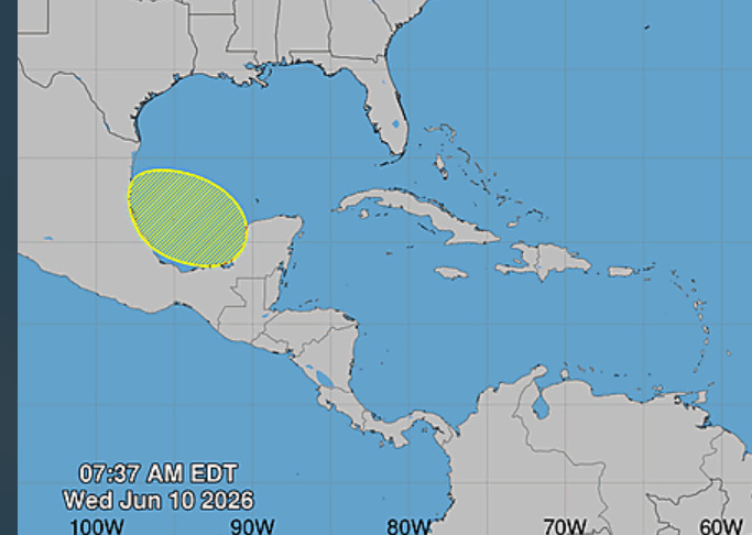
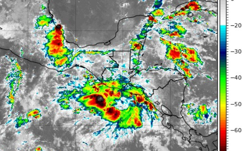
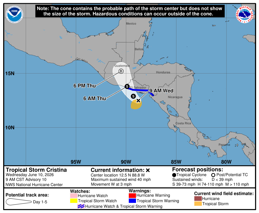
The remnants of east pacific Cristina with some tropical storm warnings up along Guatemala and El Salvador now:
Forecast Lounge discussion for this system in https://flhurricane.com/cyclone/showflat...gonew=1#UNREAD
{{StormLinks|1|01|1|2026|1|Potential Tropical Cyclone One}}
{{TexasGulfRadar}}