MikeC
|
| (Admin) |
| Mon Aug 10 2026 07:13 AM |
 Three Atlantic Areas Mid-August Blew Tires. Hurricane Lala Hits Hawaii.
|
4PM ET (10AM HT) 15 August, 2026 Update
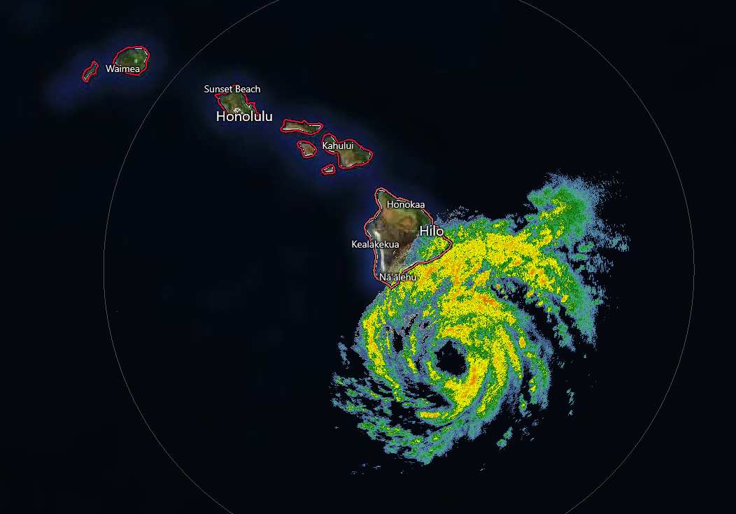
Lala has become a hurricane and is also now seemingly pulling a bit right (north) of prior track, as many of the more bullish hurricane models expected. This will bring more of the most dangerous weather to the Big Island for many hours to come, and preparations to protect life and property should already be completed, ideally.
Ciel
1PM ET (7AM HT) 15 August, 2026 Update
Recon has left Hawaii, following protocol given safety and logistic considerations. However, based on radar, satellite and microwave analysis, Lala will likely soon be a hurricane, already with a ragged eye apparent.
Track has been a little left (south) of forecast and many models (esp the hurricane models). A track that avoids landfall could preclude history books, but actually lessen the possible disruption of the center tracking over the very high mountains of the Big Island.
Regardless of exact track, this is a very dangerous tropical cyclone that will undoubtedly dump tons of rain resulting in flooding and mudslides. Preps to protect life and property should be rushed to completion.
Ciel
1:30PM ET 14 August, 2026 Update
In the Main Development Region of the Atlantic basin, Invest 92L is approaching the Lesser Antilles today with a large area of showers and thunderstorms. Development odds per NHC have dropped dramatically, now just 20%. Nonetheless, some pockets of heavy rain and winds up to 30-40 MPH in spots seems likely. Maybe not the best beach day. Behind 92L, 94L continues to have better model support for development potential and NHC still assigns it a coin-flip shot of development within the next 7 days. All in all, this historic and record-setting El Niño has drastically hampered attempts of development and/or strengthening in the Atlantic.
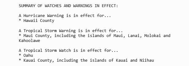
On the other side of the CONUS, Hawaii is facing a significant threat of serious impacts from Tropical Storm Lala, which is forecast to be at or near hurricane intensity during passage very near or directly over the Big Island. Preparations on the Big Island to protect life and property should be rushed to completion today. Life-threatening flooding, mudslides, winds, surge and waves are likely over the weekend.
Ciel
11:30AM ET 13, August, 2026 Update
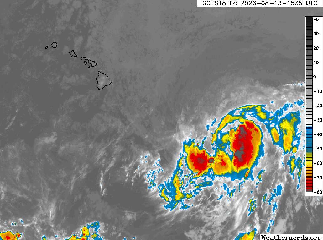
Above: Tropical Storm Lala on approach to Hawaii. Image credit: Weathernerds.org
A Hurricane Watch has been issued for the Big Island of Hawaii. Now Tropical Storm Lala is forecast to be at or near hurricane strength as it crosses the Hawaiian island. Very heavy rain will begin to impact the Big Island tomorrow, Friday, and spread throughout the chain over the weekend, resulting in potentially life-threatening flooding and mudslides.We have a Forecast Lounge up for Lala.
Elsewhere, the Atlantic basin is less than favorable for development and seeming to trend more and more inhospitable by the day. Invests 92L and 94L struggle in the Main Development Region and it is nowhere near certain that either one gets named.
Ciel
2:30AM ET 13, August, 2026 Update
Very challenging conditions for development abound throughout the Atlantic basin. The northernmost feature, a subtropical trof that broke off to the northeast, actually picked up the name Cristobal, and might be the saddest looking tropical storm of the year so far. But, there's still time for a challenger to take that title away. Invests 92L and 94L are trying.
92L has been a borderline TD for at least a half a day now. One could understand if NHC went ahead and numbered it. Models keep backing down on its potential, most now never strengthening it beyond a low-end tropical storm or depression.
94L is not especially organized still, despite occasionally sporting beefier convection than either 92L or Cristobal. Fewer ensemble models seem to want to develop this one now, also.
In the central Pacific, all eyes are on Storm One-C, still a "Potential Tropical Cyclone," but one that is already producing winds of tropical storm force. The expectation is that its elongated circulation with presently two vorticity maxima comes together as one and intensifies as it heads towards Hawaii, but this is still a little uncertain. Nonetheless, interests in Hawaii may want to begin paying very close attention, as even if One-C does not organize much more (low chance, but possible), heavy, flooding rains and strong winds will still be likely.
Ciel
Original Update
The Atlantic has three areas of interest this morning. The first area is new, the northern one, quickly moving east. It could develop into a short live system before it hits cooler waters. This has a 10% chance according to the National Hurricane Center.
The second area is the leading wave in the Central Atlantic is heading west with a 10% chance also, this one is less likely to develop and if it does likely to hit shear from the TUTT ahead of it keeping it from developing, those in the Caribbean will want to watch it still however for around Thursday.
The last area is east of there, south of the Cape Verde islands, with a 60% chance to develop, this one is likely the most prime candidate to develop, however, none of them have been invest tagged yet (this one may get tagged later today or tomorrow). It could be the one that slips through the shear, however more likely to miss the islands to the north. But those in the Caribbean still should watch this coming weekend to Monday if this system is weaker than expected. Bermuda also may want to watch much later for mid to late next week as it could get close. That's currently the most likely scenario right now, but it could change. Watch here or the lounge on flhurricane for a bit more speculation. Lounge thread https://flhurricane.com/cyclone/showflat...;vc=#Post116098 The general high shear environment of el nino is still there, and this system is likely to struggle to develop.
In the Central Pacific, invest CP93 has a 90% chance, and Hawaii should watch closely.
{{StormLinks|92L|92|4|2026|92|Invest 92L}}
{{StormLinks|Cristobal|3|3|2026|Cristobal|Cristobal}}
{{StormLinks|94L|94|5|2026|94|Invest 94L}}
{{StormCarib}}
{{HawaiiStorm}}