| cieldumort |
| (Moderator) |
| Tue Oct 06 2026 01:52 AM |

|
 Gulf Invest 92L May Defy 2026
|
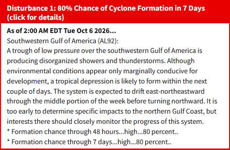
Above: NHC Oct 6, 2026 2AM EDT Tropical Weather Update on 92L
The Area of Interest we have been discussing for several days in the Forecast Lounge, now Invest 92L, has very robust, near unanimous model support for development, despite the presence of the strongest El Niño in recorded history. In reality, the next 48 to at most 72 hours is possibly crunch time for this system as if it doesn't get its act together by then, it may not have another window like this (just look at all the other Atlantic storms during the 2026 El Niño for reference).
92L is not yet a very well formed disturbance at all, and recon has not yet flown in. However, both could quickly change and in fact recon should be investigating 92L as soon as later today. Models strongly suggest that by then 92L should already have taken on more of a classic incipient tropical cyclone look, if not even be one. But, as NHC notes in the TWO above, at the moment it is still "too early to determine specific impacts to the northern Gulf Coast, but interests there should closely monitor the progress of this system." In non-NHC speak, Watches and Warnings could be going up along the northern Gulf Coast soon, just not as of 2AM EDT today.
Model deep-dives and analysis in the 92L Forecast Lounge
{{StormLinks|92L|92|9|2026|92|Invest 92L}}