| Weather456 |
| (Verified CFHC User) |
| Fri Jul 21 2006 09:14 AM |
|
|
Tropics
In the tropics, there are 4 tropical waves along 20 west, along 44 west, along 57 west and along 85 west. All waves are generally south of 22 north and are moving west at about 6 degrees longitude per day. The wave along 20 west has a small low pressure area with a swirl of clouds near 14 north. However, close up visible satellite images show African Dust wrapped around this feature. This will limit any thunderstorm development around the feature and could cause it to fall apart. The other waves look too weak and disorganized for development anytime soon. Computer forecasts show no signs of any features developing in the tropical Atlantic within the next few days.
An upper-level low located near 31 north and 70 west continues to track northward on the southwest side of the Atlantic surface high pressure ridge. No development with this weakening feature anytime soon.
Tropical Storm Beryl
A cold front moved off the East Coast of the United States in mid-July and dissipated while stalled across the western Atlantic Ocean. Two areas of low pressure developed along the dissipating front; one centered 290 miles south-southeast of Cape Cod and another located 200 miles south of Cape Hatteras, North Carolina. The first low quickly organized, though the National Hurricane Center considered development unlikely due to it moving over colder waters. The other area of low pressure initially remained broad and ill-defined. However, the system rapidly organized early on July 18 with improved banding features, and the area developed into Tropical Depression Two while located 220 miles (355 km) south-southeast of Cape Hatteras. The depression quickly organized as it moved slowly to the north-northwest, and strengthened into Tropical Storm Beryl six hours after forming.
The low-level circulation became exposed with limited deep convection on the night of July 18, though deep convection developed the following morning. Beryl maintained its northward motion due to a ridge of high pressure to its east as the storm developed deep convection and outflow improved. Warm waters allowed the storm to reach peak winds of 60 mph late on July 19 while located east of the North Carolina/Virginia state border.
Tropical Storm Beryl maintained that intensity as it parelelled the Mid-Atlantic and New Jersey, but weakened due to cooler waters on July 20.
As of 5 a.m. EDT on July 21 (0900 UTC), Tropical Storm Beryl was located 35 miles (55 km) northeast of Nantucket, Massachusetts and 365 miles (590 km) west-southwest of Halifax, Nova Scotia. It had maximum sustained winds of 50 mph (85 km/h), with higher gusts, and was moving toward the northeast at about 21 mph (33 km/h). The minimum central pressure was 1001 mbar (29.52 inHg). It is estimated that Tropical Storm force winds extend up to 85 miles (140 km) outward from the center. The storm is forecast to lose its tropical characteristics within 24 hours as it moves to the northeast.
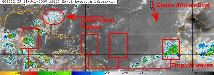
Figure 1: Location of Varoius Tropical Features on July 21, 2006
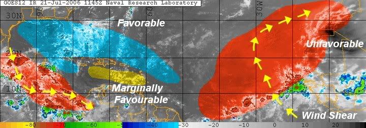
Figure 2: Tropical Formation based on Wind Shear, Dry Air and Sea Suface Temperatures

Figure 3: Tropical Storm Beryl on July 19, 2006