MikeC
|
| (Admin) |
| Sun Aug 10 2008 09:41 AM |
|
|
This is the "lounge" for 92L, the wave in the Central Atlantic. The place for just saying what you think. Don't take mine or anyone else's word for it here.
My guess is that whatever comes of 92L (if it develops or not) will remain mostly south (especially if it stays weaker now) and affect some of the islands and approach the Southeast or enter the Gulf at some point. It's the time of year where I start to take things like this a bit more serious, but any real discussion of it probably won't happen until we determine if it will form or not.
Interestingly the discussion for Houston this mornng mentions this system and they are curious to see if it'll enter the gulf.
Quote:
LASTLY...THE TROPICS LOOK TO BE GETTING MORE ACTIVE. BOTH THE GFS
AND ECMWF ARE IN GOOD AGREEMENT WITH A SYSTEM APPROACHING FL/CUBA
BY AUGUST 19TH. CONDITIONS LOOK FAVORABLE FOR THE SYSTEM TO
DEVELOP. 500 MB FLOW SHOWS A BREAK IN THE RIDGE AND A WEAK TROUGH
MOVING ACROSS THE OHIO VALLEY. AT THIS TIME...THE SYSTEM LOOKS
LIKE IT`LL TURN TO THE NORTH OVER THE EASTERN GULF. BEARS WATCH.
| WeatherNut |
| (Weather Master) |
| Sun Aug 10 2008 10:10 AM |
|
|
the 6z gfs goes nuts with this and has it going up the east coast but not into the gulf. Its way out and models are not that good long range but it is getting better organized today. This season seems to be favoring these waves as there is a distinct lack of shear
| craigm |
| (Storm Tracker) |
| Sun Aug 10 2008 10:49 AM |
| Attachment |

|
|
|
Although 10 days out is hardly reliable this is what the GFS is telling us right now about 92L but, will obviously change. The ridge seems to be intact at 240 hrs.See attached image
| WeatherNut |
| (Weather Master) |
| Sun Aug 10 2008 12:00 PM |
|
|
quite true...it is a long way out. Focusing on today, there is increasing organization and definite rotation (at the mid levels possibly). There is also outflow beginning to establish. I would not be surprised to see this classified by 11pm
| LoisCane |
| (Veteran Storm Chaser) |
| Sun Aug 10 2008 12:15 PM |

|
|
|
well that's quite the eye opener
yeah.. models imply it gets to our part of the world
it's looking better currently but there is real dry air out there and the high dips a bit
not sure if that would be the first wave or second..
we'll see
worth looking at would be Clark's intensity model from the main page
http://i.flhurricane.com/images/2008/clarki6latest.png
| ftlaudbob |
| (Storm Chaser) |
| Sun Aug 10 2008 02:52 PM |
|
|
|
|
Every blog I have read are saying basically the same thing,we are about to get very active.All the elements appear to be coming together.And because of where that High pressure is it does not look like we will have any fish spinners for a while.This is the time to really stay alert and check your supplies.
| CAT5Cane |
| (Registered User) |
| Sun Aug 10 2008 03:16 PM |

|
|
|
It's definitely getting very active in the tropics as we approach mid August. We now have three waves to watch in the eastern Atlantic.
- CAT5 Cane
Altamonte Springs, Fla.
| Hugh |
| (Senior Storm Chaser) |
| Sun Aug 10 2008 04:33 PM |
|
|
Looks like someone said "the tropics are quiet" a bit too loud...
92L is certainly the further along of the two current "active" systems, but it's not there yet. Convection
is currently on a downward trend after having been very impressive earlier today. Assuming it eventually develops, which I suspect will happen by Tuesday, the models seem to want to take it further north than I would have guessed from the upper-air flow maps I've seen. Puerto Rico, the D.R./Haiti, Cuba, the Bahamas, and ultimately Florida will need to keep an eye out, I believe, but that's a long way off.
| Storm Hunter |
| (Veteran Storm Chaser) |
| Sun Aug 10 2008 08:04 PM |

|
|
|
nice discussion here... from HPC today 8/10/08
... A DEEP CYCLONE
DIGS SHARPLY FROM SW-CENTRAL CANADA INTO THE US TO THE LEE OF THE
RIDGE...LEADING TO A RETROGRESSION OF AN EARLY WEEK ERN NOAM
TROUGH BACK TO THE E-CENTRAL US. THE COOLING SYSTEM SHOULD ALSO
ACT TO FOCUS A LINGERING PERIOD OF POTENTIALLY LOCALLY HEAVY
RAINFALL AS DEEP GULF MOISTURE FEEDS/POOLS DOWNSTREAM. THE EXTENT
OF MID-UPPER LEVEL TROUGH/CLOSED LOW DIGGING DIFFERS BETWEEN
MODELS AND ENSEMBLES BUT THERE IS A CLEAR RECENT TREND TO FAVOR AN
INCREASINGLY AMPLIFIED SOLUTION. EVEN ACTING CONSERVATIVELY FOR
AUGUST...AN AMPLITUDE THAT DEVELOPS NEAR THE MIDDLE OF THE FULL
RANGE OF MODEL AND ENSEMBLE MEMBER SOLUTIONS WOULD STILL PRODUCE
QUITE A POTENT TROUGH WITH 500 MB HEIGHTS UPWARDS OF 3 STANDARD
DEVIATIONS BELOW NORMAL. THIS WOULD BE SIMILAR TO THE EARLY TO
MID AUGUST 2004 PATTERN. THIS SEEMS CONSISTENT AS PER EXPECTED
STRENGTH OF THE UPSTREAM RIDGE IN ALMOST ALL MODEL AND ENSEMBLE
RUNS. THIS TROUGH COULD EVEN PUMP UP DOWNSTREAM WESTERN ATLANTIC
RIDGING ENOUGH TO ALLOW FOR THE POSSIBILITY OF TROPICAL
DISTURBANCES NEAR THE GREATER ANTILLES/CARIBBEAN SEA. .......
| Unregistered User |
| (Unregistered) |
| Sun Aug 10 2008 09:27 PM |
|
|
the local weather men say it holds together it may slide up the east coast in about 1 week the could be about 200 to 300 hurdred miles of the georgia coast and may trurn to the north what do you think?
| Unregistered User |
| (Unregistered) |
| Sun Aug 10 2008 09:42 PM |
|
|
This post was sent to the Hurricane Graveyard
| Unregistered User |
| (Unregistered) |
| Sun Aug 10 2008 09:44 PM |
|
|
i live in mass and we havent been hit since bob .i have to say the water is very warm and the could support a major hurricane it will be interesting to see what happens would do you think?
| Unregistered User |
| (Unregistered) |
| Sun Aug 10 2008 09:58 PM |
|
|
i understand what you are saying and my is to monter weather i just listened to the westher channel and they stil it if it holds together threating the east could as you should know anything could happen think?
| Unregistered User |
| (Unregistered) |
| Sun Aug 10 2008 11:19 PM |
|
|
Convection is spotty but there is a mid to upper level swirl going on. Probably a TD tommorrow. Models take it smack ala Chris track. Although some uncertainty abound.
|
MikeC
|
| (Admin) |
| Mon Aug 11 2008 08:49 AM |
|
|
Looking at long range models this morning is not for the squeamish (particularly This one (check the 216 hour projection).
Luckily though, these usually are so far off its not worth checking (Very far into the Lounge area), but still seeing that raises an eyebrow or two. I mirrored it here in case the old one gets updated here.
All this means is that it's worth watching, and I don't think it will do what that projection says.
Better news that the newer model runs are losing support for both systems and 92L isn't too healthy now, so there is an even better chance that either system is just not going to do much (I hope).
| ftlaudbob |
| (Storm Chaser) |
| Mon Aug 11 2008 09:16 AM |
|
|
|
|
In the last couple of frames it looks like it is starting to get better organized.
www.ssd.noaa.gov/goes/flt/t1/loop-avn.html
| MissBecky |
| (Weather Guru) |
| Mon Aug 11 2008 02:03 PM |

|
|
|
Looking at both the visible satellite and the infrared, I'm much more impressed (and a little concerned) with 93L at this hour than with 92L. It will be interesting to see what the models do with both these systems tomorrow, once we have recon data.
| hurricaneguy |
| (Weather Hobbyist) |
| Mon Aug 11 2008 03:10 PM |

|
|
|
Currently IMHO 92L will be a bigger threat towards the US. I think 92L will slowly begin organization later tonight and tomorrow maybe at times fighting for its life. However, once the storm makes it to the N Leeward Islands, it will be in a better enviroment to gain momentum. As of right now, 93L looks like it will be a fish.
| allan |
| (Weather Master) |
| Tue Aug 12 2008 12:00 PM |

|
|
|
Ok, 92L does look better but Dr. Masters in Wunderground did show the quickscat this morning and showed an open wave. Sooo I don't think it becomes a TD today, possibly and best bet is tomorrow. The track has me questioning, south Florida or Gulf. It's always possible that it could go my direction as some of the models pointy out at the end of there runs with a northward movement.
93L... You all say fish, I say we need to watch it. I see no recurvature with it as high pressure is just too strong. Maybe if the ridge breaks down a bit, it could go north.. but not before hitting Bermuda. 93L actually looks horrible on satellite so it might take a few days for it to develop. Don't forget guys, you can't ALWAYS go by what the models show. the GFDL is NOT showing a recurvature, just a northward movement, could go west after that poleward movement.
| SeaMule |
| (Weather Hobbyist) |
| Tue Aug 12 2008 04:12 PM |

|
|
|
I never post until i get a "feeling". Is that wierd?
We have a code red from the Navy site, a locked in Bermuda high, and early consolidation of the models, notably the GFDL and the euro... on a path missing the main islands and skirting through the keys, into the gulf....
I will be watching this site and hoping the moderators, especially Hank Frank and the owners of this site...keep us update
oh, and it's August...hmmm
Katrina....August
Andrew
Camille....
to name a few
(Post was moved - Model projections/discussions belong in the Forecast Lounge.)
| weathernet |
| (Storm Tracker) |
| Tue Aug 12 2008 05:20 PM |
|
|
As of late this afternoon, recon was unable to close off a low, with regard to 92L. Also interestingly enough, there seemed to be slightly lower pressures south of 15N, most notibly south of what certainly appears as a fairly well developed mid level rotation.
Most recent model data from 12Z today shows the European model as being quite consistant in the last 2 days runs, in bringing a low WNWward north of the Greater Antilles, and generally toward the S. Florida area. GFDL 12Z run now has a 101kt. hurricane in the S. Bahamas moving WNW. GFS has been consistant in carrying a week low also towards the WNW ( between Cuba and S. Fla. ), though not yet developing it into anything. Latest 18Z NAM now bringing a deepening TS or hurricane west to WNW ( in 84 hrs.) just north of Dominican Republic. NAM doen't start to really wind up 92L until about 48 hr's, while GFDL is a little more "bullish" , showing development practically right away. Will be curious to see if the latest 18Z GFS run starts to join in tandem with some of the other runs, in developing 92L, or if it continues to be unimpressed with the system.
Visually, I am distinctly more impressed with the mid level circulation appeareant on vis. satellite, and yet less impressed with 92L downward pulse with regards to its appearance on IR. I do not see easterly shear, but in fact southerly to SW'erly shear. Upper air charts seem to indicate that an upper anticyclone develops over the system, with SW shear seemingly retrograding westward ( yet never quite to far to the west of 92L ).
Hurricane Andrew was an odd storm and a freak of nature - one that developed in a year so very different from this one. Only similarity at all, is how Andrew, after gaining significant latitude just east of the Lesser Antilles, suddenly bumped into a wall of a building ridge off the Southeast U.S., and suddenly turned sharply westward. In our current year, we are already seeing a potential for some long tracking systems ( al la Bertha ), and tracks which may originate in the W. Carib./Gulf. Would seem to me slightly out of place for a storm to form just east or north of the Virgin Islands, then to track westward from there. No doubt 92L is a weak system which could just as easily dissipate, however cannot help but take notice of model guidance. The consistancy of any model run, as would consistancy among the runs, at minimum bare our attention.
(Post moved to the appropriate Forum - see comments above.)
| Unregistered User |
| (Unregistered) |
| Tue Aug 12 2008 06:18 PM |
|
|
On Friday we are driving from Beaumont Texas to Vortex Springs for a scuba class. The naysayers have said, "Hey, it will be cancelled because of all that activity--like 92L!". By my calculations, the earliest it could, if it did, threaten Pensacola would be mid next week and we will be safely back in Texas with our certifications in hand. It would be nice to have a way to estimate when a storm "might" be somewhere. I based my estimate on the speed and current location. I agree that the models are somewhat useless this far out.
| metwannabe |
| (Weather Hobbyist) |
| Wed Aug 13 2008 12:10 AM |

|
|
|
Looking at 92L tonight, the path ahead and the models right now. I think this is an either it does or it doesn't type of system, there will be no in between. In other words, if it develops I see nothing in the way of allowing this to become a strong storm (as a scary GFDL shows) or it may never develop at all as some of the other models are showing.
It is a long way out and it still has to actually develop but being in eastern NC, I have seen storms before go into the Bahamas and make that turn to us. The last few frames of the GFDL show a NNW movement and IF, IF, IF there is a Fay at that time, there does not appear to be a high in place to keep it going straight west.
Next Recon will be very important. Either way not too early for all along east coast to start paying attention.
| weathernet |
| (Storm Tracker) |
| Wed Aug 13 2008 09:15 AM |
|
|
It is quite curious to see how the GFS continues to handle 92L consistantly. In that, the system as a whole simply continues to move WNW'ward without any significant development. In striking contrast, the GFDL has been equally consistant in wanting to develop 92L into a hurricane and just as consistantly brings 92L along just north of Hispanola, S. Bahamas, and then through the Florida Straights. Well, as of this posting ( and data per the 6Z respective model runs ), the GFDL continues to bring a minimal hurricane towards S. Florida, ( though has backed off yesterdays intensity forecast of over 100kt's ) and the GFS has not budged and continues to stubborningly insist that nothing more than an open wave will ever develop. In contrast, the seemingly more conservative European Model, has been surprisingly consistant in wanting to develop 92L, and carry it WNW'ward on a track curiously similar to that of the GFDL. In years past, I would notice how little more than a one isobar low, perhaps with only a hint of "yellow" on the Euro map, would often come to pass as a developed storm, as forecasted. This is not to say that the Euro has not come up with its own share of "ghost" storms, but the frequency of this seemed far less common to occur. As of the 8/13/08 - 0Z run, the European model now depicts a similar long range track, though now quite impressively developing it as a much deeper cyclone, and for the first time, carries this as a strong system through the E. Gulf, than northward towards the Florida panhandle.
Forecasting is certainly not as simple as "model-casting". Some models such as the Canadian, I simply do not pay much attention to. Others such as GFS, GFDL, EURO, or UK seem to carry a little more weight. Then one need to take into consideration overall conditions, and even overall tendancies of that given year. I would be surprised to see much development of 92L over the next 36 hours. It would not be unlikely for it to disipate altogether, but should it maintains its integrety and continue to show some level of circulation with some maintained bursting of convection, than will be quite interesting to see what the future holds in about 48 hours from now. This is when upper air seemingly improves enough for conditions to become more favorable for possible development.
Next question beyond "if" 92L develops, is where. Low level flow would want to take the system perhaps more westward, while mid level would tend to develop a system slightly farther to the north. Lets see what things look like early Friday...... :?:
| Steve H1 |
| (Storm Tracker) |
| Wed Aug 13 2008 09:42 AM |
|
|
I agree that dry air and shear from the nearby ULL(s) is inhibiting development. That said, I am concerned that once this area gets NW of Puerto Rico the environment become more favorable it will develop, and this is backed up by the Globals, Namely the Euro, along with the GFDL, which looks to make this a significant cyclone in the southern Bahamas/Florida Starits. If this occurs. timing will be critical as to when a turn to the NW will occur, where the Euro shows this paralleling the west Florida coast then up towards the panhandle. But that's a few days down the road. I believe 92L will survive the next 36 hours. After that, we will need to pay close attention to it here in the sunshine state. Cheers!
(Post was moved off the Main Page since model projections belong in the Forecast Lounge.)
| tommy |
| (Registered User) |
| Wed Aug 13 2008 11:30 AM |
|
|
right now i just dont see AL92 doing anything and i have 2 words for AL93 fish storm. but i do have a ? if AL92 does form and that is a big IF. what chance is there for it going up the east coast as a weak ts. so for the models are fighting on just where it will go if it does form . now this is just me i have 2 track . one it staying on the east side of the island then crossing cuba geating into the caribb. then falling apart . track #2 going up the east coast as a weak ts. staying out over water .
tommy
(Post moved to the appropriate Forum.)
| Unregistered User |
| (Unregistered) |
| Wed Aug 13 2008 04:02 PM |
|
|
Looks like a TD to me (92L)
Some models hinting at GoM development later this week.
Dont think 93L will be a fish spinner.
| Unregistered User |
| (Unregistered) |
| Wed Aug 13 2008 05:58 PM |
|
|
I'm a long time reader first time poster. The thing that I keep noticing on the model runs is the consistentcy in 92L's track. Is everyone in agreement pretty much of the general track and the big question now is the intensification when it gets to the Florida Straights?
| doug |
| (Weather Analyst) |
| Wed Aug 13 2008 07:24 PM |
|
|
The models are very consistent for 72 hours, so go with that for now. Everything will be revised IF it begins to strengthen.
What 92 L needs to strengthen is a consistent inflow of moisture, which may now be beginning from the SSE. I see subtle changes in the last few hours that are consistent with better structure. It will probably get more attention tomorrow.
|
MikeC
|
| (Admin) |
| Wed Aug 13 2008 07:54 PM |
|
|
I don't see it becoming a depression tonight or tomorrow (unless it's late tomorrow, if that), and the models went from trending to go into the Gulf this morning to curving north before Florida today. I wouldn't believe a single one of them outside of 48 hours right now. Not until this thing develops,. the longer it remains weak the more likely it is to head more toward the west.
| weatherguy08 |
| (Weather Hobbyist) |
| Wed Aug 13 2008 08:26 PM |
|
|
I think I'm leaning a little more towards the European model seeing as it is almost dead on if you look back at its Monday forecast and compare to where it is now. It was a little to far north, but was just about perfect as far as longitude goes. Also, it takes a more westerly path than a northerly path because it is a weaker storm right now and would not respond to a weakness in the subtropical ridge as much as a stronger storm would.
|
MikeC
|
| (Admin) |
| Wed Aug 13 2008 08:54 PM |
|
|
Ok, perfect for the lounge are more of the models tonight. NOGAPS sticks it into Florida, GFDL curves it north before florida, similar to the GFS, although the extra long range GFS then stalls it out off the coast for a day or so then moves it back westward over Florida (which is possible if a ridge develops over it at the time). The other interesting thing is nearly all the models are making the system into a hurricane.
It is also possible the system moves more westward than thought and into the Dominican Republic, so there is a lot of possibility here too, and if it does that it would mean big impacts for that and Hati, but possibly less for us.
However this is the lounge, these models right now are about as good as throwing darts blindfolded and drunk. Although the trends are what to look for, (check out the animations on the front page) Still look for somewhat a better idea if this system develops, and hopefully we'll know more over the weekend. However, Florida and the Southeast will want to know about the possibility something will be close early Tuesday-Wednesday , and the possibility for a storm stalling off the coast is also there. The bad thing about the current model trends, is if it were to approach Florida it would be at an angle that would make pinpointing a landfall very very difficult. (and again points at and just north of the landfall would see the worst). I still hold out it will remain weak and move more west.
1. Wait to see if the Storm actually develops
2. Watch it closely over the weekend (especially model trends)
| craigm |
| (Storm Tracker) |
| Wed Aug 13 2008 10:27 PM |
|
|
|
|
Looks like 92L is finally fighting off dry air , shear and SAL. Gaining traction tonight with blowup of convection as opposed to the pattern we have seen over the past few days. Models are struggling with intensity the next couple days creating typical windshield wiper effect with output. Some have hinted at recurve east of the bahamas the last couple runs but that has since changed. What's worrying me is what the 3 and 5 day cone is going to look like when 92L is upgraded which if this convection holds could be tomorrow.
| weathernet |
| (Storm Tracker) |
| Wed Aug 13 2008 10:44 PM |
|
|
Craig makes a good point that "in the event of development between tonight and tomm. night, we'll soon see 3-5 day cone of error cover a chunk of territory, perhaps including a large swath of the Bahamas and Florida. Would make for a pretty quick "ramp up" in preliminary preparations, even if not suddenly a strong foreboding system. Given the warmer SST's along 92L's potential WNW path, at least some of the conditions would seem to point towards potential continued strengthening. Then again, as Mike pointed out in a recent post, a developing depression or weak storm could slam into Hispanola, and while dumping copious amount of rain ( potentially dangerous in itself ), further development could be thus squelched due to interaction with "the big rock".
I had noticed as others commented on the more recent model trend to recurve close to the Florida penninsula. I had not seen any 8/14 - 0Z data yet suggesting model consistancy of the same, nor a bend back to the west. True enough though, that as a weaker system, the more westward it will likely be driven in the short term.
As a side note.........., I too see the overall organization and appearance of the systems envelope, along with some concentrated convection, as looking better at this time than yesterday evening. :?:
| LoisCane |
| (Veteran Storm Chaser) |
| Thu Aug 14 2008 12:31 AM |
|
|
|
|
A real problem there for NHC on their 5 day cone if they upgrade it tomorrow. Going to be a long night there.
Looking very good on all floaters, real twist, swirling... has to have a closed center now.
We'll see soon but what will that cone look like?
| Storm Hunter |
| (Veteran Storm Chaser) |
| Thu Aug 14 2008 12:41 AM |
|
|
|
|
Quote:
A real problem there for NHC on their 5 day cone if they upgrade it tomorrow. Going to be a long night there.
Looking very good on all floaters, real twist, swirling... has to have a closed center now.
We'll see soon but what will that cone look like?
we will have a good idea in a hr or so.. NOAA43 is inbound now from about 18.45N 61.07W at 14800ft... based on flight path so far and data... they have dropped two GPS dropsonds on the outer area of the invest... from 14kft... one GPS took 5 mins to hit the water... got what looks like real good data. the 06z runs and or 12z model runs should have the data in it.
| weathernet |
| (Storm Tracker) |
| Thu Aug 14 2008 02:28 AM |
|
|
Given the increased data from recon early this a.m., will be interesting to see "if" and "how" various trending models will ingest the increased data, thus altering or reconfirming recent model tendancies. I would expect at minimum, better initialization ( location and motion ), often a point of contention for some models.
I had not checked, but after the current recon, when is the next scheduled mission?
|
MikeC
|
| (Admin) |
| Thu Aug 14 2008 06:40 AM |
|
|
This morning the model runs are looking much better for turn right and out to sea scenario (including the GFS based models), which may or may not happen, recon influenced model runs may happen later today. Until this storm develops it may be hard to say, but I hope the models continue to trend right and keep it away from the US.
| MissBecky |
| (Weather Guru) |
| Thu Aug 14 2008 06:59 AM |
|
|
|
|
Quote:
This morning the model runs are looking much better for turn right and out to sea scenario (including the GFS based models), which may or may not happen, recon influenced model runs may happen later today. Until this storm develops it may be hard to say, but I hope the models continue to trend right and keep it away from the US.
I'm not so sure about this. The 00Z NOGAPS and UK model bring 92L straight over/into Florida. In fact, the NOGAPS run reminds me quite strongly of Charley's path (and since yesterday was the 4-year anniversary of that storm, I sure didn't need to be reminded of it!)
Those two models are very different from the GFDL and GFS, which are initialized from the same data. What could be causing such a big difference?
|
MikeC
|
| (Admin) |
| Thu Aug 14 2008 08:23 AM |
|
|
Quote:
I'm not so sure about this. The 00Z NOGAPS and UK model bring 92L straight over/into Florida. In fact, the NOGAPS run reminds me quite strongly of Charley's path (and since yesterday was the 4-year anniversary of that storm, I sure didn't need to be reminded of it!)
Those two models are very different from the GFDL and GFS, which are initialized from the same data. What could be causing such a big difference?
I'm thinking the Nogaps is wrong on this one. The best way to handle something like this is to try think "Why wouldn't it hit the US?" instead of why it would.
In this case, it looks like it may head more west than north in the short term, which may cause some interaction with Hispaniola, if it does it will tear it up some, and now the models are trending to pull it north, which makes the north and out to sea scenario a bit more likely, and luckily keeps it away from Florida.
Even the GFDL this morning gets the system close to the somewhat coast but stays off shore where no direct effects could be felt (other than large waves). I'm cautiously optimistic about 92L right now not heading toward Florida, but I still want to see what recon finds today and will be more interested at looking at the system over the weekend than today or tomorrow.
Right now I don't trust the models, but I like what I see if it continues trending north and east.
| weathernet |
| (Storm Tracker) |
| Thu Aug 14 2008 09:00 AM |
|
|
With regards to the models, I would agree that current tendancies would lean now - or are favoring recurvature. If in fact 92L is deepening, than I would have to be even more inclined that motion would be distinctly tied to mid level flow rather than surface or shallow flow. Longer term guidance seems to want to possibly hook a system back NW'ward possibly towards the Carolina's or Mid Atlantic seaboard. "If" such building of a ridge were to occur, than wherever any such TC might ( if still close to the U.S. coastline ), such a possible west ot NW motion could ensue. Here too, is where model casting is really tricky business because even temporary stalling due to a system deepening, or a less anticipated COL, would affect forward speed of motion, thus also impacting future motion.
To my eyes, there truly does exist "such as reason" why 92L may never impact the U.S. mainland. It's current appearant westward motion ( 270-280 degrees ) would seem to have 92L on a mountain climbing excursion. Any disruptive interaction with Puerto Rico or even moreso with Hispanola, could entirely disrupt or destroy the systems circulation. This looks to me to be perhaps more likely than quick development to be followed by recurvature.
| SeaMule |
| (Weather Hobbyist) |
| Thu Aug 14 2008 09:06 AM |
|
|
|
|
It is already a depression...imho....anyone ever see such a nice anti-cyclonic ridge above a 'wave" before...
they will have their hands full with this one...
| Ed in Va |
| (Weather Master) |
| Thu Aug 14 2008 09:09 AM |
|
|
Agree. Its current path takes it right over those two islands. We need to see how that plays out before we can really make any good guesses on its fate.
| Unregistered User |
| (Unregistered) |
| Thu Aug 14 2008 11:34 AM |
|
|
So based on the latest tracks, a northward turn is expected, which would result in FL being avoided altogether. I am from SE FL, and I'm just wondering what the chances are of this system affecting my area. Yesterday the tracks had me more nervous, but there seems to be a trend in that the tracks continue to shift to the east.
| ftlaudbob |
| (Storm Chaser) |
| Thu Aug 14 2008 11:40 AM |
|
|
|
|
Quote:
So based on the latest tracks, a northward turn is expected, which would result in FL being avoided altogether. I am from SE FL, and I'm just wondering what the chances are of this system affecting my area. Yesterday the tracks had me more nervous, but there seems to be a trend in that the tracks continue to shift to the east.
It is not even a TD yet,so the models are generally not that accurate at this stage of a system.I myself don't really pay that much attention to the models till it becomes a TS.It is inching closer,so it needs to be watched closely.
| Unregistered User |
| (Unregistered) |
| Thu Aug 14 2008 11:47 AM |
|
|
So what will determine at what point the system turns north?
| scottsvb |
| (Weather Master) |
| Thu Aug 14 2008 11:49 AM |
|
|
vis satellite shows the LLC exposed to the WNW of the area of convection and passing over Anguilla heading about 275dg. I dont think they will make this a TD until the convection fires over the LLC. Winds are in excess of 40kts and it would probably bypass the TD status when this happens. I guess they could still upgrade it early if they feel they want to give out TS warnings to Puerto Rico.
Longer range is up in the air. I still follow the GFDL, and even though model trends 1 way from run to run, sometimes they jump right back to where they were predicting 24hrs ago.
| saluki |
| (Weather Hobbyist) |
| Thu Aug 14 2008 11:54 AM |
|
|
Quote:
So what will determine at what point the system turns north?
Steering currents will play a big role. If a high-pressure ridge is in place, the storm would be steered more to the west. If there is weakness in the ridging, a more northward path is likely. I'm not a met, but hopefully this rather simple explanation is somewhat accurate.
| Unregistered User |
| (Unregistered) |
| Thu Aug 14 2008 11:59 AM |
|
|
Yes it does, thanks. Does anyone know which tracks have a history of being most accurate?
| Unregistered User |
| (Unregistered) |
| Thu Aug 14 2008 12:04 PM |
|
|
Hello there...
I read your forums all the time and have for the past few years. I work in the media and it's part of my job to send crews out to cover these things so I have to keep up on all the projections so I know where we have to be.
My first question is--what model do you all think has proven to be more accurate with past storms? Most seem to agree with each other but then there always seem to be 2 or so that completely differ.
Thanks for your help!
| ftlaudbob |
| (Storm Chaser) |
| Thu Aug 14 2008 12:10 PM |
|
|
|
|
Quote:
Hello there...
I read your forums all the time and have for the past few years. I work in the media and it's part of my job to send crews out to cover these things so I have to keep up on all the projections so I know where we have to be.
My first question is--what model do you all think has proven to be more accurate with past storms? Most seem to agree with each other but then there always seem to be 2 or so that completely differ.
Thanks for your help!
I like the GFDL model.
The last couple frames of the WV,lead me to believe it may skip TD status and go right to TS Faye.Take a look:
www.ssd.noaa.gov/goes/flt/t1/loop-wv.html
| MichaelA |
| (Weather Analyst) |
| Thu Aug 14 2008 12:20 PM |

|
|
|
Even the floater vis loop looks like a strong TD or minimal TS. We'll see when the recon gets in there soon.
| scottsvb |
| (Weather Master) |
| Thu Aug 14 2008 12:35 PM |
|
|
when a storm gets classified, go with the GFDL unless its the outliner of models and also if the NHC says disregard it. Sometimes it will have a bad feedback of data in it (like any model can). Anyways GFDL model with the ECMWF and GFS blending in.
| scottsvb |
| (Weather Master) |
| Thu Aug 14 2008 12:39 PM |
|
|
everyone seems to miss the point that the LLC is exposed over Anguilla. Until it fires convection (which it will eventually) near the LLC...it wont be classified unless, #1 they want to give out T.S Warnings to Puerto Rico or 2, the Recon finds another LLC in the area of convection, but with saying that, the LLF shows the exposed center to be the dominate 1.
| MichaelA |
| (Weather Analyst) |
| Thu Aug 14 2008 12:53 PM |
|
|
|
|
In the last frames, that LLC seems to have dissipated. It's looking like it may be reforming under the convection. When is the recon due in the system?
| CDMOrlando |
| (Weather Hobbyist) |
| Thu Aug 14 2008 01:01 PM |

|
|
|
Quote:
when a storm gets classified, go with the GFDL unless its the outliner of models and also if the NHC says disregard it. Sometimes it will have a bad feedback of data in it (like any model can). Anyways GFDL model with the ECMWF and GFS blending in.
Scott is right.
PRELIMINARY EXTENDED FORECAST DISCUSSION
NWS HYDROMETEOROLOGICAL PREDICTION CENTER CAMP SPRINGS MD
959 AM EDT THU AUG 14 2008
AND THE NOAA DROPSONDES RELEASED IN VICINITY OF THE LOW THIS MORNING WERE BEFORE MODELS INITIALIZATION. THEREFORE...INITIALIZATION ERRORS COULD BECOME AN ISSUE.
USED YESTERDAYS COORDINATED TRACK FOR THE POSSIBLE TROPICAL SYSTEM
OVER THE BAHAMAS AND FLORIDA...WITH A SIMPLE EXTRAPOLATION FOR THE
DAY 7 POINT IN LIGHT OF THE WIDE SPREAD IN THE GUIDANCE. THE 00Z
GEM GLOBAL SENDS THE SYSTEM SOUTH OF CUBA...REPRESENTING THE LEFT
SIDE OF THE DYNAMICAL MODEL ENVELOPE...WITH THE 00Z AND 06Z GFS
SHEARING THE SYSTEM NORTHEASTWARD ACROSS BERMUDA DEFINING THIS
GUIDANCE TO THE RIGHT. WILL HAVE ANOTHER COORDINATION WITH TPC
TODAY AND TAKE A FRESH LOOK AT THIS SYSTEM.
| WeatherNut |
| (Weather Master) |
| Thu Aug 14 2008 01:10 PM |
|
|
Not missing the point...just missing the center you were speaking of. I think the center has reformed at 18N 61W. Outflow is starting to expand in all quadrants. The inflow is also now moving in the direction of the MLC at the above location. I think this is already Fay.
| MichaelA |
| (Weather Analyst) |
| Thu Aug 14 2008 01:23 PM |
|
|
|
|
I'm seeing the same thing and your coords appear to be right on. Looks like a TS to me, too. Also looks to be spinning up rather quickly.
| mikethewreck |
| (Weather Hobbyist) |
| Thu Aug 14 2008 01:24 PM |
|
|
|
|
I agree, 92L looks like it may have gotten its act together.
Living in Florida, I have been watching this storm like a hawk. Does it look like the re-formation of 92L/Fay brought it south enough that the mountains of Puerto Rico and Hispaniola might get a chance to rip her apart before she gets up closer to my neighborhood? (Not wishing a hit on the islands!)
Still remember Andrew going north of the islands and then being driven in to South Florida by the Bermuda high...
| ftlaudbob |
| (Storm Chaser) |
| Thu Aug 14 2008 01:28 PM |
|
|
|
|
My two cents:
I think the LLC has reformed,and we now have Faye.
| craigm |
| (Storm Tracker) |
| Thu Aug 14 2008 01:34 PM |
|
|
|
|
If it looks , walks and quacks like a duck what is it? I'm sorry I'm starting to think this is more a function of not alarming interests along the east coast of the U.S. at the expense of timely warnings for the Northern Leewards. I realize the system is tilted and we need good sound data but, it sure looks like more than an invest to me. Hopefully they are all paying close attention in the islands. Anyone agree with me?
| mikethewreck |
| (Weather Hobbyist) |
| Thu Aug 14 2008 01:45 PM |
|
|
|
|
Didn't 92L/Fay drive right through Hebert's Box? I know that is "old school" forecasting, but storms that do get my attention here in Florida...
| ftlaudbob |
| (Storm Chaser) |
| Thu Aug 14 2008 01:46 PM |
|
|
|
|
For what it's worth.............This thing is in the Hebert Box.
If you don't know what the Hebert Box is,please do a search.
| Ed in Va |
| (Weather Master) |
| Thu Aug 14 2008 01:57 PM |
|
|
Hebert's link:
http://www.hurricanecity.com/hebertbox.htm
| MichaelA |
| (Weather Analyst) |
| Thu Aug 14 2008 02:12 PM |
|
|
|
|
There seems to be some inconsistency here.
From the 2:05 PM TWD:
Quote:
TROPICAL WAVE IS IN THE W TROPICAL ATLC/E CARIBBEAN ALONG
61W/62W WITH A 1009 MB LOW ALONG THE WAVE NEAR 18N MOVING W
10-15 KT. WHILE THE ASSOCIATED THUNDERSTORM ACTIVITY HAS BECOME
MORE CONCENTRATED...MOST OF THE ACTIVITY IS LOCATED WELL EAST OF
THE LOW CENTER AT THIS TIME.
61W;18N is directly under the convection, isn't it?
| Unregistered User |
| (Unregistered) |
| Thu Aug 14 2008 02:21 PM |
|
|
I was wondering if there is any chance of this depression/storm coming into the Gulf Of Mexico?
I have not seen any information in the last 2 days on this website to support that.
I live in Louisiana and was wondering what would have to happen for this storm to enter the gulf.
If it goes into the gulf do any of you think that there is a chance that it will come near La.?
I know that it is very early to predict, but alittle worried about any storm that gets into the gulf.
Thanks guys and keep up the great work here. I enjoy your website and have learned alot over the years.
Thanks!
| Unregistered User |
| (Unregistered) |
| Thu Aug 14 2008 02:21 PM |
|
|
Yes, "looks" to be a TD by now. Let's hope this one goes the way of the fishes as the long range models suggest.
(Post moved to the appropriate Forum.)
| SeaMule |
| (Weather Hobbyist) |
| Thu Aug 14 2008 02:23 PM |
|
|
|
|
Perhaps the "activity" located well east of the LLC is forming it's own LLC...along with the LLC that started 92L to begin with. If there is no LLC below the blowup of convection, then the storm is in it's infancy still...and when that quadrant wraps around the exist LLC that they think is west of the blob...we'll have a huge system. However, it SURE DOES LOOK like the blob has it's own spin to it. I might not be very smart, but i know what a blob is....lol
so to recap...is the LLC under the huge fire up of convection...or east of it..??? or are there going to be two?
who knows. ONe thing for sure...it's growing....
| CDMOrlando |
| (Weather Hobbyist) |
| Thu Aug 14 2008 02:26 PM |
|
|
|
|
EXTENDED FORECAST DISCUSSION
NWS HYDROMETEOROLOGICAL PREDICTION CENTER CAMP SPRINGS MD
115 PM EDT THU AUG 14 2008
COORDINATION WITH TPC RESULTED IN DIRECTING THE
POSSIBLE TROPICAL SYSTEM NORTHWARD EAST OF FLORIDA...BUT AGREED
WITH THE SPECIALIST THERE THAT CONFIDENCE IN EITHER THE STRENGTH
OR TRACK OF THIS LOW IS QUITE LOW. THE 12Z GEM GLOBAL TAKES THE
SYSTEM SOUTH OF CUBA...THEN LIFTS IT INTO THE EASTERN GULF OF
MEXICO...WHILE THE GFS TRACKS IT NORTHWARD WELL SHORT OF THE
FLORIDA COAST IN A HEAVILY SHEARED ENVIRONMENT.
| Unregistered User |
| (Unregistered) |
| Thu Aug 14 2008 02:47 PM |
|
|
Look at the latest model runs Mickey, and tell me whether that continues to be the present circumstance or not? Just some food for though there for you. Farewell!
| weathernet |
| (Storm Tracker) |
| Thu Aug 14 2008 02:49 PM |
|
|
"Faybe yes and Fabe no". As recon data continues to come in, I saw one extrapolated report of 1004mb ( at 17.7N & 61.5W ). As well, some various wind reports of winds near 40kt. This all said, the strongest west wind I had noticed as of about 10 minutes ago, was about 8mph. Here's my take.....
I believe 92L is a depression by most definitions, yet truly still tilted somewhat. Though what I have seen would seem to close off a low, there is certainly the chance while this system is "on the cusp", for the convection to wane, and perhaps go through yet another cycle perhaps this evening or early tommorrow a.m. to finally get its act together. Still remaining a distinct possibility of this borderline shallow system to track 270 degrees ( westward ) and be disrupted by P.R. In fact, as I type this, the cloud tops have warmed slightly, and it is my own opinion that given a continuity of deep convection, even in close proximity to the westward tilted lower surface pressures, it would have been tagged a depression by 5:00pm. If there is a pause in the deep convection and the cloud tops much less cold than earlier, than it may be borderline enough to delay an upgrade to depression. This all said, slow continued organization may still require such designation tonight. I do not believe "Fay" will be named immediately, IF upgraded later today or evening. If upgraded in the very near term, I believe to a depression. Tommorow a.m could be another thing.
With regards to forecast models, I have a good respect for the GFDL, but moreso AFTER the TC is a fairly established vertical system. All models may be viewed with a little more accuracy when a "true fix" may truly establish actual location and forward speed of motion. This said, I have always looked at the GFS, UK, and Euro as well for motion. NOGAPS as well, though it tends to be very conservative on intensity. Of course one need look at the BAMD layer too ( given a well established TC ). Only caviot is that here too, I find certain models to carry small Trop. Cyclones better, while larger Hurricanes tend to not only be affected by downstream influences, but tend interact and even alter certain upper or mid level impacts.
In looking at the latest 12Z GFDL, it appeared to me that there was a slight ( and I do mean slight ) track adjustment towards the west. Look, all of the models, even if consistant will vary at least a little from run to run. Simple point would seem to be that "if" this system does not get disrupted by land, than the upper air seems conducive for a Tropical Storm or hurricane to be just north of the Greater Antilles for at least a couple days. After that, could recurve - could move westward. There does not yet seem to be too much confidence in the 4-7 day steering flow over the Bahamas / S.E. U.S. yet. This picture may become clear soon, but not quite yet.

| WeatherNut |
| (Weather Master) |
| Thu Aug 14 2008 02:53 PM |
|
|
They have not flown into that area but keep flying where the former center (or soon to be former) is. Hopefully they will fly into the area we all can see is going to be the center soon if not now. what good is recon if they are not sent to the place where the weather is occurring. Its kind of maddening in a way
| weathernet |
| (Storm Tracker) |
| Thu Aug 14 2008 03:03 PM |
|
|
Quote:
I was wondering if there is any chance of this depression/storm coming into the Gulf Of Mexico?
I have not seen any information in the last 2 days on this website to support that.
I live in Louisiana and was wondering what would have to happen for this storm to enter the gulf.
If it goes into the gulf do any of you think that there is a chance that it will come near La.?
I know that it is very early to predict, but alittle worried about any storm that gets into the gulf.
Thanks guys and keep up the great work here. I enjoy your website and have learned alot over the years.
Thanks!
Strictly opinion here, and that based on longer range steering that still may be nebulous. A weaker system that could have treked westward through the Greater Antilles could certainly reach the Gulf. Or, a potentially stronger storm having gone more WNW just north of the Greater Antilles could enter the Gulf as well. What I am seeing downstream appears to be a weakening trough which is bent N.E. / S.W. Looks to me that a big building ridge somewhere over the Southern Plains is moving or bridging eastward in time. Timing is everything here. My guess is that even if a storm were in the E. Gulf, that it would seem to have to be steered more westward in such a set up. That would tend to have the W. or N.W. Gulf more at risk. Again, this is assuming a big northerly retreat of the westerlies with a big mid level high over or near Texas. This would be my guess if this were work its way into the Gulf.
Remember, maps and models change, and its only a "best guess" based on current data that may not prove accurate.
|
MikeC
|
| (Admin) |
| Thu Aug 14 2008 03:07 PM |
|
|
Newest GFDL Rides the East coast of Florida, EMCWF brings it through central florida then into the Central Gulf into MS/Alabama area. Looks like a shift back west, still not completely developed though so it remains suspect. But those are some of the latest for those asking. A good rule of thumb is two full runs of models after a storm has actually formed.

Edit, also Dvorak numbers are up to 2.0, so formation of a depression tonight is fairly likely.
| Unregistered User |
| (Unregistered) |
| Thu Aug 14 2008 03:26 PM |
|
|
I sure hope that the gulf is not a possibility. What I want to know is what is the CMC trying to form in the gulf long range?
| Unregistered User |
| (Unregistered) |
| Thu Aug 14 2008 04:44 PM |
|
|
I'm seeing the first signs of nw and west winds from the recon Maybe a Depression at 5pm,
| Unregistered User |
| (Unregistered) |
| Thu Aug 14 2008 04:49 PM |
|
|
SPECIAL TROPICAL DISTURBANCE STATEMENT
NWS TPC/NATIONAL HURRICANE CENTER MIAMI FL
5 PM EDT THU AUG 14 2008
DATA FROM NOAA AND AIR FORCE RESERVE HURRICANE HUNTER AIRCRAFT...
ALONG WITH SURFACE OBSERVATIONS AND SATELLITE IMAGERY...INDICATE
THAT THE LOW PRESSURE AREA LOCATED OVER THE VIRGIN ISLANDS HAS NOT
DEVELOPED INTO A TROPICAL DEPRESSION. HOWEVER...UPPER-LEVEL WINDS
ARE BECOMING MORE FAVORABLE FOR DEVELOPMENT...AND A TROPICAL
DEPRESSION COULD FORM AT ANY TIME DURING THE NEXT DAY OR TWO AS THE
SYSTEM MOVES WEST-NORTHWESTWARD ABOUT 15 MPH.
REGARDLESS OF DEVELOPMENT...THIS SYSTEM COULD BRING LOCALLY HEAVY
RAINS AND GUSTY WINDS TO PORTIONS OF THE NORTHERN LEEWARD
ISLANDS...THE VIRGIN ISLANDS...PUERTO RICO...AND HISPANIOLA DURING
THE NEXT DAY OR TWO. INTERESTS IN THESE AREAS...AS WELL AS IN THE
SOUTHEASTERN BAHAMAS AND EASTERN CUBA...SHOULD MONITOR THE PROGRESS
| Storm Hunter |
| (Veteran Storm Chaser) |
| Thu Aug 14 2008 07:51 PM |
|
|
|
|
i about spit my drink out this morning when i saw the 12Z cmc... perfect conditions for a major cane in the EGOM coming mid next week... ERR!!! i am starting to think though... this may be a GOM threat... i would have expected that 92L be a TD by now... and with the islands now... i think it may take longer for it to get going at the surface. and farth west i would expect the track
| LoisCane |
| (Veteran Storm Chaser) |
| Thu Aug 14 2008 08:37 PM |
|
|
|
|
Really good comments tonight here. Not much I can add.
There is one main area of convection, bright red on IR tonight and its on radar so if they can't find a center soon I don't know when they will. Can a mid level hover just above the surface? I remember a storm several years back that had 3 flights into a wave that looked like it was a strong Tropical Storm before they could find the elusive west wind.
The models have been very good on this so far and so that is good. Down the line it's a very hard forecast for the NHC. IF it does follow the coast of Florida the slightest variation of degrees right can make the difference between landfall at Pt. Everglades, WPB or just clipping the Cape. That's down the road and right now we don't have a designated storm.
NHC makes the call.
| Hugh |
| (Senior Storm Chaser) |
| Thu Aug 14 2008 08:41 PM |
|
|
I cannot get the SJU long-range radar to show for some reason to see what the circulation looks like on radar, but on satellite, it clearly looks like it should have been upgraded to Fay by now.
The new model runs trending toward a EGOM track northward are VERY concerning... hopefully they will shift back to the east away from the east coast of Florida completely.
| jessiej |
| (Weather Watcher) |
| Thu Aug 14 2008 09:19 PM |
|
|
The new models are out. They are all hooking way to the east in the Bahamas and missing Florida.
| Hugh |
| (Senior Storm Chaser) |
| Thu Aug 14 2008 09:37 PM |
|
|
Until it actually forms, models are, as others have said, pretty much useless. I don't understand why they wold be hooking that far east when the LLC is moving due west, but we'll see what happens if it survives the mountains.
| flanewscameraman |
| (Weather Watcher) |
| Thu Aug 14 2008 09:47 PM |
|
|
At this point, this "Wave", "Depression" "Storm" is going to do what she is going to do. the mets in Puerto Rico are calling for a head on hit for the island, and it will be interesting to see what this does to the circulation. Right when you think we are getting a handle on this system, she throws a twist.. I thing tomorrow will have some more answers, or perhaps not....
| Hugh |
| (Senior Storm Chaser) |
| Thu Aug 14 2008 10:03 PM |
|
|
Looking at the SJU long-range radar now, the apparent LLC is just on the edge of the radar's range, moving basically due west on a course that will take it just north of San Juan. That'll put the strongest side of the storm away from the island, and keep it over water, I'm afraid. Comparing the radar with the AVN loop, it does appear that the LLC has not yet tucked itself completely in the middle of the convection, but that's not shocking since the system has not yet been classified (when the circulation is apparent on radar, and it's so close to land, I would have thought the NHC would go ahead and pull the trigger, but they haven't.... but the convection has not persisted for several hours over a single LLC, either).
| craigm |
| (Storm Tracker) |
| Thu Aug 14 2008 10:27 PM |
|
|
|
|
Quote:
Really good comments tonight here. Not much I can add.
There is one main area of convection, bright red on IR tonight and its on radar so if they can't find a center soon I don't know when they will. Can a mid level hover just above the surface? I remember a storm several years back that had 3 flights into a wave that looked like it was a strong Tropical Storm before they could find the elusive west wind.
The models have been very good on this so far and so that is good. Down the line it's a very hard forecast for the NHC. IF it does follow the coast of Florida the slightest variation of degrees right can make the difference between landfall at Pt. Everglades, WPB or just clipping the Cape. That's down the road and right now we don't have a designated storm.
NHC makes the call.
LC- I just posted the following on Ed Dunhams recent forum--
'Ed-- could you help us understand how a system with this type of satellite presentation is not a depression despite the calm winds at the surface. I have been tracking storms for a long time and do not remember a senario like this.'
Touches on what you are mentioning about MLC. I just don't get it!
| metwannabe |
| (Weather Hobbyist) |
| Thu Aug 14 2008 10:30 PM |
|
|
|
|
I was just about to comment that I think I see the "LLC" on the east edge of PR long range radar loop. Convection has fired just a bit s/sw of the "LLC". Most of the models that hook this out to sea or atleast take it east of Fl also initialize the system farther north than where it appears to be (has huge implications on projected path).
With now appearing to have maintained its westward movement, it is going to be really difficult for this to recurve without some impact on land.
I know the mountain ranges in Dom Rep/Haiti are tall and would (and have in the past) disrupt this system but what about the effects of PR if it goes directly over them?
| Hugh |
| (Senior Storm Chaser) |
| Thu Aug 14 2008 11:26 PM |
|
|
There are some high areas of Puerto Rico, as well. Don't know how they compare to DR/Haiti, but they're pretty high (I drove up one 20 years ago).
The center appears to be moving all over the place... with a burst of convection forming northeast of Puerto Rico now. Amazing how quickly things change in developing systems.
| scottsvb |
| (Weather Master) |
| Fri Aug 15 2008 12:33 AM |
|
|
Erin 1995 lived all over again the middle of next week? Well the GFS thinks so on the New Oz run. Maybe alittle stronger like Jeanne. It's (to be honest) a very plausable scenerio with the trough exiting later this weekend into early next week and getting replaced by a strong ridge from Tuesday-Friday..anything under that ridge will slide W then WNW into the Gulf.
Too many things can still happen. It could get stronger earlier before 75W and catch the trough or it could even stay weaker and move closer to cuba then approach the keys and head more W across the southern gulf later next week. We will have a better idea every 12hrs and by Sunday 12z runs...we will have a very good idea on what is happening.
This is why we all love trying to forecast the evolvement of Tropcial systems and weather in general. !!
| saluki |
| (Weather Hobbyist) |
| Fri Aug 15 2008 12:49 AM |
|
|
Yipes! I was just looking at that GFS scenario and in the 21 years I've lived here don't remember anything just sitting there around southeast Florida like that -- closest thing to it probably was Jeanne, which moved north and looped back to the south and west before landfall; there's virtually no movement at all in this one for a few days. Guess the best thing to keep in mind if you're in Florida (or points further west based on the evolution of the GFS scenario) is the caveat that the models aren't that trustworthy at this point.
| weathernet |
| (Storm Tracker) |
| Fri Aug 15 2008 01:18 AM |
|
|
Puerto Rico does offer up some decent mountain ranges. I remember years back when I chased Hurricane Hugo. First we were on the north coast, then traveled down to Ponce, then crossed the island northward via a nice highway system in place there, and finally back to Luquillo/Farjardo area. I cannot however recall a decent sized tropical cyclone with a good size wind field actually torn apart from the island. I good hurting to a storms symetry - certainly a disruptive force. I have found that a storm will tend to "jump" or relocate more easily when passing near or over P.R., than what I call "the rock" ( Hispanola ).
Tonights GFS run from 0Z certainly does join the camp of previous Euro, UK, NOGAPS, and GFDL models. Also contrary to recent GFS runs, this one not only stalls the cyclone, but really intensifies it as well. In noticing the NAM, I realize it too has been very consistant run to run, however seems to fast. I think the GFS solution is certainly plausable due to the COL created by a lifting trough and the building ridge. Timing would dictate if such a stall were to occur east of Andros Island, farther North or South along the Florida coastline, or even in the S. Bahamas. I just do not see recurvature as a likely event with the westerlies retreating northward while simply leaving a week hanging ocluded surface trough. More likely to me that recurvature would occur, would be for 92L to be severly disrupted by Hispanola.
| weathernet |
| (Storm Tracker) |
| Fri Aug 15 2008 01:21 AM |
|
|
Speaking of odd tracks, it just occured to me how curiously similar this potential track skirting just north of the island and possibly impacting S. Florida would be to Hurricane Donna. Any "older" Floridians here remember that one?!

| Clark |
| (Meteorologist) |
| Fri Aug 15 2008 03:13 AM |
|
|
Quote:
LC- I just posted the following on Ed Dunhams recent forum--
'Ed-- could you help us understand how a system with this type of satellite presentation is not a depression despite the calm winds at the surface. I have been tracking storms for a long time and do not remember a senario like this.'
Touches on what you are mentioning about MLC. I just don't get it!
Satellite can be very deceiving because, as it looks from the top-down and IR/visible satellite cannot look through clouds, you won't see the surface features in the midst of a region of convection. IR satellite is generally going to be poor at looking at surface features, anyway. You can use visible satellite to track low cloud motions outside of convection during the day, but even that won't be perfect.
Ultimately, though, convection like that which we've seen with 92L is a conduit for a lot of heat release in the mid-upper levels of the atmosphere. That helps spawn a mid-level vortex/circulation, often also referred to as a mesoscale convective vortex (MCV), in those levels. This heating will help force lower surface pressures and, in some cases, the development of a low-level circulation beneath the MCV. Sometimes, though, convection will fire away from a pre-existing surface circulation, often causing there to be competing focal points for development. Heating because spread out over a large spatial extent rather than focused near one circulation (whether surface or mid-level). This can slow and hinder the development process until one feature becomes dominant.
The satellite appearance we have seen with 92L today is indicative of a healthy upper-level environment, one which has favored a convective burst to the NE of a pre-existing surface circulation. This convection helped spawn the development of an MCV around which further convection could organize. Outflow aloft is still present with these features too, giving the system the appearance of a healthy tropical system. But, alas, with no surface reflection or organization, you don't have a tropical cyclone. Often, though, these features are immediate precursors to tropical cyclone development! They are common in the Caribbean with fast-moving storms, where the storm motion is so fast to prevent there from being a closed surface circulation, and with disturbances in the deep tropical Atlantic that are in the early stages of development.
All in all, with everything but land interaction favorable, 92L is on the precipice of development...but given the limiting factors above, that's sorta how it can have the appearance that it does without yet being a tropical cyclone.
| ftlaudbob |
| (Storm Chaser) |
| Fri Aug 15 2008 11:18 AM |
|
|
|
|
Local news here are now giving hourly updates on this wave.
| Brett Addison |
| (Registered User) |
| Fri Aug 15 2008 11:40 AM |
|
|
It appears to me that we have Faye just from the satellite presentation. If the storm does get destroyed by the future land interactions I think that the NHC will classify this storm as a tropical storm at the end of the season. This storm just looks too good to just be considered a tropical wave and not a depression or storm. I would also advise the governments of Puerto Rico and the Dominican Republic to start issuing tropical storm warnings.
| Unregistered User |
| (Unregistered) |
| Fri Aug 15 2008 01:21 PM |
|
|
last GFS run showed a Cat 3 in Tampa

Sure hope thats wrong.
| Lee-Delray |
| (Weather Master) |
| Fri Aug 15 2008 02:11 PM |

|
|
|
I'm looking a the 12z model swing, its amazing. Do you think they picked the llc up furhter SW?
| MissBecky |
| (Weather Guru) |
| Fri Aug 15 2008 02:36 PM |
|
|
|
|
Met office in Tampa is finally doing more than referring to a possible tropical wave.
...UNCERTAINTY IN TROPICAL SITUATION MEANS LITTLE CHANGE IN
FORECAST UNTIL/WHEN/IF/WHERE A STORM ACTUALLY DEVELOPS...
The Lee County Emergency Operations Center has issued a notice regarding possible severe weather affecting Southwest Florida late this weekend or early next week. It's good to see that folks here are paying attention, even without an official notice from the NHC.
| Robert |
| (Weather Analyst) |
| Fri Aug 15 2008 02:39 PM |

|
|
|
GFDL Now takes it well out into the gulf of mexico
|
MikeC
|
| (Admin) |
| Fri Aug 15 2008 02:59 PM |
|
|
Until you have a low level center/it forms, take the models with a heap of salt, period. Lots of smoke right now, but no fire yet.
| Unregistered User |
| (Unregistered) |
| Fri Aug 15 2008 03:12 PM |
|
|
I do remember Donna, was a teenager at the time. Of course as a teen that was an adventure but no longer.
| Cat 5orBust |
| (Weather Hobbyist) |
| Fri Aug 15 2008 04:34 PM |
|
|
This certainly will go down as an oddity as I cant recall anytime in recent memory where you had a storm that looked very good, but did not have the essential characteristics to not be given a name. As far as what may happen: The models continue to shift until a center is fixed, but the only constant in these models is a turn to the north at some point. Having said that, I dont see the high building in much more before it begins to possibly retract to the east a bit more and create the northward turn. If this 92L does make it to the Gulf, I dont see it getting much further west in my opinion and thus would threaten the easternmost gulf sates as the extreme western location. I think this slow turn will begin sooner rather than later and will threaten Florida in some way. Obviously the key is where the center sets up shop and how much land it interacts with. If it holds its own then you most likely will see fairly impressive strenthening. If it becomes ragged over land, then you may have a sloppy tropical storm impacting Florida.
| Mike V |
| (Weather Watcher) |
| Fri Aug 15 2008 05:25 PM |
|
|
I've been in several storms down here in Miami since 59, but one thing stands out with all of them. The birds tend to disappear before a storm comes. I have not seen any song birds since this AM, Plenty of doves and pigeons (don't know why they don't leave, I guess they hunker down), but definitely no songbirds.
Me thinks fay will hit this part of the coast, and I believe it may be a minimal hurricane.
Sorry if that is not scientific enough for the rest of ya (and btw, the info on this site is priceless), but I've just seen these signs too many times.
MV
| madmumbler |
| (Storm Tracker) |
| Fri Aug 15 2008 06:06 PM |

|
|
|
All I know is the 5pm 5-day forecast is NOT something I wanted to see. Ugh. It's got a bullseye right on us here at Charlotte Harbor, and this close to the Charley anniversary, it was not a welcomed sight.
Not wishing it anywhere, but I'm hoping that little black line slides to the west or hooks a hard right to sea.
Guess I know what I'm doing this weekend. Time to get the generator fired up and the boards ready to go.
Ugh.
The only good thing I liked seeing was it running up Cuba's spine. Not good for Cuba, but hopefully it would tear it apart enough to take some of the starch out of it before/if it hits FL.
| Unregistered User |
| (Unregistered) |
| Fri Aug 15 2008 07:16 PM |
|
|
I totally agree with you, wildlife is the best thing to tell whats coming, we are in Oldsmar, Tampabay area and the wildlife activity has been seriously decreased. No birds no squirels no lizards and the gators are hunkered down.
We have been having storms off and on for most of the day. LOL Im begining to think, I am solar powered....
I think this one is coming into the Gulf, the one behind it is something to keep an eye on too.
You are right this is the best site to get info from, hubby works for wfla 8, and all the media is hype driven for ratings..... there is no hype here pure fact and stellar veteran experience.
| Unregistered User |
| (Unregistered) |
| Fri Aug 15 2008 08:19 PM |
|
|
I dont know. Drew Park tampa here. Squirrels, gators, cats and birds out and being annoying as usual wish they would go into hiding.
I used to work at Reptron in oldsmar

| Unregistered User |
| (Unregistered) |
| Fri Aug 15 2008 08:21 PM |
|
|
This storm has a pretty large axis. Imo, its going to effect tampa/west coast ALOT. Regardless.
| IMTechspec |
| (Verified CFHC User) |
| Fri Aug 15 2008 10:13 PM |
|
|
Quote:
This storm has a pretty large axis. Imo, its going to effect tampa/west coast ALOT. Regardless.
Along those lines, I wonder how large the core, the eye and radius of damaging winds will be as it approaches landfall? My guess is that it has the potential to be relatively large.
If Fay lives through the islands, I suspect that when she finds some open friendly water, some of those areas that have competed for the LLC might consolidate into something a little larger. Watching the observations from the Recon planes as they sampled the various areas of the storm this afternoon, started me thinking about the potential for a larger system if it can survive and stay together. As always, lots of ifs.
A "half full" perspective on a storm like this approaching Florida with an uncertain path;
Everyone needs to pay attention to it. It has only been a couple of years since FL was impacted by a hurricane, yet there is a noticeable level of complacency. Even if there were to be a South Florida landfall, folks there will have the weekend to finish preparations. Not like the 2004 Parade of Hurricanes, where they always showed up on Fridays and Saturdays, so that you had to try to prep during the week, often in the evenings... For those that did prep!
Hopefully people here in Florida will prep like mad this weekend, and then Fay will fall apart. That certainly would not be anything to be disappointed about. All of that prep is still a good investment, and not just for Hurricanes.
| Hugh |
| (Senior Storm Chaser) |
| Fri Aug 15 2008 10:31 PM |
|
|
Well, the NHC finally decided to pull the trigger. This is the first time I can remember that they pulled it on a system over Hispanola. Long-range model outputs are extremely disturbing to me... the latest runs move further west than the 5pm forecast, and plant a bullseye on my head, it would seem. Hopefully the storm will move whereever it's going fast enough not to gain significant strength.
| Unregistered User |
| (Unregistered) |
| Sat Aug 16 2008 01:02 AM |
|
|
Based on the 11pm discussion, I think Panama City, Fl is the current bullseye:
"..ONE SHOULD MENTION HERE THAT IN
GENERAL...MOST OF THE GUIDANCE HAS SHIFTED WESTWARD AND THE
OFFICIAL FORECAST IS ON THE EASTERN EDGE OF THE ENVELOPE. BEFORE I
AM COMMITTED TO SHIFT THE TRACK FARTHER WEST...I WOULD RATHER WAIT
TO SEE IF GUIDANCE BECOMES MORE STABLE FROM ONE RUN TO THE NEXT."
| Storm Cooper |
| (User) |
| Sat Aug 16 2008 01:34 AM |
|
|
Well, Panama City is not in the clear for sure but there are still many things to play out before there is a really firm track to Fay. This may seem "old" but much of the Gulf Coast (East as well to a degree) needs to watch this system. There are many factors that can/will dictate what happens as to the track and we don't have a long time to watch and to prepare...as with long-tracking systems....Fay is knocking at someones back door now...excuse me while I answer that

| DarleneCane |
| (Verified CFHC User) |
| Sat Aug 16 2008 08:05 AM |

|
|
|
Did the GFDL just move more to the east bringing Fay over the Upper Keys and up the state of Florida. I'm confused I thought that it was further west. I haven't heard much talk about it. Why would it do that? Has intensity forecast of storm changed or the strength of the Low over the US that could pull it sharper to the north? I have always felt the center could go over the upper keys, possibly close to Key Largo making that swing and up through the Everglades though not sure at what exact angle affecting Naples more or the East Coast more.
|
MikeC
|
| (Admin) |
| Sat Aug 16 2008 08:07 AM |
|
|
The latest run moved quite a bit to the east, I'm not sure if it's just a model screwiness or a general trend right now, that solutions would keep it over water much much less, at least, but it's still suspect while the storm is over land.
| ftlaudbob |
| (Storm Chaser) |
| Sat Aug 16 2008 08:15 AM |
|
|
|
|
The models will be shifting east and west and back again for the next couple of days.

The LLC is now back over water,let's see if she gains strength,before going over Cuba.
|
MikeC
|
| (Admin) |
| Sat Aug 16 2008 08:26 AM |
|
|
Quote:
Did the GFDL just move more to the east bringing Fay over the Upper Keys and up the state of Florida. I'm confused I thought that it was further west. I haven't heard much talk about it. Why would it do that? Has intensity forecast of storm changed or the strength of the Low over the US that could pull it sharper to the north? I have always felt the center could go over the upper keys, possibly close to Key Largo making that swing and up through the Everglades though not sure at what exact angle affecting Naples more or the East Coast more.
I looked into this a bit more, this and the HWCF moved east and judging from the init data looks like a bad run, you can probably ignore this, throw it out the window and wait for the next one.
| ftlaudbob |
| (Storm Chaser) |
| Sat Aug 16 2008 08:42 AM |
|
|
|
|
My biggest concern is we really won't know where it's going to go or how strong she will get until it leaves Cuba,and by then it will be so very close the S.Florida and the keys.There is reason to believe she could rapidly intensify over the very warm waters between Cuba and S.Florida.
| Wxwatcher2 |
| (Storm Tracker) |
| Sat Aug 16 2008 09:44 AM |

|
|
|
Hello All,
I haven't posted in quite awhile, usually just content to read everyone's opinion and comments.
Interesting observation overnight is how the center has moved South off the coast of Hisanola and actually is on course toward Jamaca. I suspect a gradual turn to the WNW today and since she's over water, a good amount of intensification.
Everyone from the Keys on up the Florida West coast needs to watch this one.
By this time tomorrow, hopefully the models will come to a concensus on where Fay is headed and the local EOC's can begin
to make the proper preparations and plans.
| JMII |
| (Weather Master) |
| Sat Aug 16 2008 10:16 AM |

|
|
|
Quote:
Interesting observation overnight is how the center has moved South off the coast of Hisanola and actually is on course toward Jamaca.
I noticed the same thing. The more south she goes the more west the track should shift. However that will also delay her arrival, as with all these system timing is critical.
Also just gotta say that WeatherUndergrounds new "WonderMaps" are awesome, you can see the satellite image overlaid with track data, local weather wind icons, radar and wind field projections, with amazing zoom level detail.
| Unregistered User |
| (Unregistered) |
| Sat Aug 16 2008 10:43 AM |
|
|
Clark, I've noticed you and scottsvb have referred favorably to the ECMWF model but I can't identify it by those initials on the various plots linked to these pages. Which one is it??
|
MikeC
|
| (Admin) |
| Sat Aug 16 2008 10:45 AM |
|
|
That also goes by the European, the latest NHC track takes it through Lee County, I know those who went through Charley do not want to hear that, however it also looks like things are still uncertain about the center of Fay, so it could go either way.
The next few days are going to be very difficult.
| Rosy |
| (Registered User) |
| Sat Aug 16 2008 11:10 AM |
|
|
|
We certainly don't need another hurricane in Lee County, but I was hoping for some rain. This wait-and-see game is the worst.
| ftlaudbob |
| (Storm Chaser) |
| Sat Aug 16 2008 11:10 AM |
|
|
|
|
I hope this shift east does not continue.What about this thing coming off the gulf coast,looks like that could push Faye more east.
www.ssd.noaa.gov/goes/east/watl/loop-wv.html
| Unregistered User |
| (Unregistered) |
| Sat Aug 16 2008 11:20 AM |
|
|
Most of y'all probably have this in your toolbag, but I just found it this morning : http://tropicalatlantic.com/models/#ta. IUsing googleEarth, you can display model tracks, recon data, radar and clod coverage in google earth
| WeatherNut |
| (Weather Master) |
| Sat Aug 16 2008 11:31 AM |
| Attachment |
|
|
I think that there are many similarities to the track of Cleo in 1964 which I attached
| ftlaudbob |
| (Storm Chaser) |
| Sat Aug 16 2008 11:35 AM |
|
|
|
|
Quote:
I think that there are many similarities to the track of Cleo in 1964 which I attached
I don't like that track!

| SirCane |
| (Storm Tracker) |
| Sat Aug 16 2008 11:51 AM |

|
|
|
I noticed the "cone" goes all the way to MS/AL. Should the Pensacola area be at all concerned?
Here's hoping it goes to a sparsely populated area.
| enterlaughing |
| (Registered User) |
| Sat Aug 16 2008 11:58 AM |

|
|
|
OK - first time FL hurricane for me.....I understand the entire cone area is affected. I lived 20 miles west of Houston back when Alicia hit Galveston. I know the power it had even after traversing land and coming inland. Just a forecast guess, guys and gals, should I put my hurricane panels up in Winter Haven?
| Lamar-Plant City |
| (Storm Tracker) |
| Sat Aug 16 2008 12:01 PM |

|
|
|
I don't put too much stock in the latest shift back east. We are at the 'ping-pong' stage for these models. It goes left one run and right the next. What we need to do is watch for trends and a narrowing of the cone. Cone width indicates the confidence in the models. Since this is the forcast lounge and speculation is OK, I am declaring this a southeastern GOM storm. RIght now, there seems to be a balance between weakness to the north and its tendancy to continue west. However, the farther west this storm goes and at this fast pace, the harder it will be to make a hard right turn, especially with land interaction. THis is just my opinion and I have been wrong before.....lots.
| TheOtherRick |
| (Weather Watcher) |
| Sat Aug 16 2008 12:24 PM |
|
|
I wonder if the models sufficently take into account the effect of the high mountains of Hispanola on a disorganized tropical wave/storm. Could it kill off the northern and central parts of the low, leaving only the southern part, with it's center 90 miles south of the predicted track as the convection seems to indicate?
Putting it over water, not Cuba, and sending it into the Gulf, not Florida.
But what do I know?
| Unregistered User |
| (Unregistered) |
| Sat Aug 16 2008 01:09 PM |
|
|
This post was sent to the Hurricane Graveyard
| Unregistered User |
| (Unregistered) |
| Sat Aug 16 2008 02:40 PM |
|
|
That comment about st. pete getting leveled is very irresponsible. You never know who is reading this forum. You need to provide at least some kind of information to back that up, besides the statement they are "over due". A Cat 1 (though I have learned after ten years of tracking hurricanes predicting intensity is very difficult) would not level st. pete, even on a direct hit, which hardly any models presently suggest that. Not to sound sharp, I just did not like that comment.
| DarleneCane |
| (Verified CFHC User) |
| Sat Aug 16 2008 04:02 PM |
|
|
|
|
Why is everyone jumping onto every shift in the model track and not comparing the new ones with the old ones?
To hype a hit for Tampa is irresponsible this far out. It hasn't finished with Cuba and we have no idea which part of
Cuba will take the brunt of this storm. And, it is possible it stays on the eastern tip that I don't believe has high mtn ranges. Desert like conditions around Gitmo.
With the GFDL swinging back to the favored path yesterday of the East Coast Scenario I believe anything beyond figuring out today and tomorrow is wild speculation and panics people.
The question remains. Is the high to the north of Fay (a weak high) strong enough to keep her westbound or weak enough to allow her to begin moving more to the north.
Do not be fooled into believing a storm has to make a gradual turn from w to wnw to nw to nnw.. no it doesn't. They often stop in mid-stream.
On the water vapor imagery all afternoon there have been pop up showers in the straits where the river of dry air was positioned to the nw of Fay. It's almost gone and the barometer has dropped in Miami from a healthy high of 30.05 this morning to 29.99 this afternoon (with no rain storms anywhere to account for the drop) so look at the water vapor loop like Clark said and see which way the moisture is going.
It is very reasonable to believe the GFDL is on to something. Either it's your "go to" model or it's not. But the track from the NHC will take both the HWRF and the GFDL into account and they will find a balance.
Stop looking at the words TAMPA on TWC and focus on the whole state because much of Florida will have to deal with Fay soon.
And, the center is just reaching the tiny eastern tip of Cuba and if it is beginning to lift to the wnw then it won't be over land for very long.
| MichaelA |
| (Weather Analyst) |
| Sat Aug 16 2008 05:02 PM |
|
|
|
|
The 5PM forecast "track" has shifted ever so slightly to the West bringing Fay very near Venice/Sarasota on Tuesday afternoon - a little faster and slightly weaker than the previous forecast. It's still 4 -5 days out, so this track and intensity will vary as more data is collected for each model run. I'm making my preparations today and tomorrow before the last minute folks swamp the stores on Monday/Tuesday. As stated several times, everyone in the FL peninsula should be making preparations before Monday. Keep in mind that a Cat 1 storm is very survivable and some of us "old salts" would regard it as slightly more than a nuisance (with healthy respect, of course).

|
MikeC
|
| (Admin) |
| Sat Aug 16 2008 05:07 PM |
|
|
Here's the headache inducing part of the storm, intensity is a crap shoot...
From the 5PM 8/16 Discussion:
Quote:
When fay is over water... it appears that atmospheric conditions will be favorable for strengthening through 72 hours. Thus... the intensity will be controlled by land interaction and the resulting impacts on the storm structure.
All guidance continues to forecast strengthening... and the intensity forecast follows suit in bet agreement with the ships model. However... this is a low confidence intensity forecast. Fay could strengthen rapidly if it becomes well organized over water, such as while passing south of Cuba,, or over the straits of Florida, on the other hand... it might not strengthen much at all if land interaction prevents organization.
So the current intensity forecast is a compromise, hopefully the forecast is too strong. This is the part that probably causes the hurricane center the most grief with warning issuance.
| DarleneCane |
| (Verified CFHC User) |
| Sat Aug 16 2008 05:25 PM |
|
|
|
|
A bit confused here.
The 5pm discussion clearly said the track was moved up a bit faster and a bit to the East. While I am sure that Naples is in that cone they said specifically east.
They also call for a sharp turn. So where she turns makes all the difference.
| MichaelA |
| (Weather Analyst) |
| Sat Aug 16 2008 05:33 PM |
|
|
|
|
Quote:
A bit confused here.
The 5pm discussion clearly said the track was moved up a bit faster and a bit to the East. While I am sure that Naples is in that cone they said specifically east.
They also call for a sharp turn. So where she turns makes all the difference.
Yes, they said East, but the track is slightly West of the 2PM intermediate advisory. It is slightly East of the 11AM advisory.
| Hugh |
| (Senior Storm Chaser) |
| Sat Aug 16 2008 05:41 PM |
|
|
Quote:
Yes, they said East, but the track is slightly West of the 2PM intermediate advisory. It is slightly East of the 11AM advisory.
They do not update the forecast track in intermediate advisories. The new model runs are done at the time of the intermediates, but the official forecast is not changed until the full package is sent out, unless there is a drastic change in strength, in which case they will issue a new strength forecast sometimes. I've never seen them change the track.
| JMII |
| (Weather Master) |
| Sat Aug 16 2008 05:49 PM |
|
|
|
|
The only thing that worries me is the outflow. From the get go this storm has an excellent outflow thus if it every gets it act together it could blow up. Now with that said its looking very ragged right now, even the NHC said the winds are down. The interaction with the land is starting to do the damage to its structure we all excepted over Haiti.
My original thought is still holding up pretty good: Fay moved further south, thus the track went west and the time line for arrival has slowed. While the east coast isn't out of the woods yet I don't think we'll see much from this system even after it hops Cuba as it only has small window to pickup steam. Some where between the Panhandle and points north of Ft. Myers would be my guess-timate at this time at Cat 1 level only.
The Water Vapor loops (my favorite tell-all for storms) shows a spin ahead that will draw the storm further west, so I think the turn to the north will be later (and slightly sharper) then NHC shows, however the end result will be the same. Hard to judge that front stalled to the north, it seems to just be sliding east now, not sure when its going to break down and/or begin to draw Fay north.
One thing is for sure: it going to be very windy in Key West come Monday. That should give us a good feel for the true natural of this particular storm.
| WeatherNut |
| (Weather Master) |
| Sat Aug 16 2008 06:48 PM |
|
|
It is now starting to shrug off some of the effects of land. There have been 2 or 3 big bursts of convection near the center. I think I saw the LLC still a little out front but that center could be pulled under the new convection thats firing up. That would also keep the center south of the 24hr projected path...not a good thing as more time over very warm water with very high heat potential
| Trekman |
| (Weather Watcher) |
| Sat Aug 16 2008 07:00 PM |

|
|
|
I was out and about a little today to the local home improvement stores, and there were a decent amount of people there. Seemed to me though that they were just there to get stuff for projects and not for storm preparation. Rumour in town though is some people are already worried about the storm. All this and at the moment we are close to the western edge of the "CONE". Time will tell
| gatorman |
| (Verified CFHC User) |
| Sat Aug 16 2008 07:31 PM |
|
|
seems people are getting a little "itchy" too itchy, wait till it starts a turn, which as it has been projected, still hasnt happened, nhc is pretty much by itself on its track everyone else is projecting a more westward track, can anyone explain this??
| Hugh |
| (Senior Storm Chaser) |
| Sat Aug 16 2008 08:50 PM |
|
|
Am I imagining things, or have the models shifted west yet again with the 00z runs? Now they seem to plant the bullseye back on the panhandle.
| MichaelA |
| (Weather Analyst) |
| Sat Aug 16 2008 09:04 PM |
|
|
|
|
At my age, I'm easily confused. It may have been the 11AM forecast that I looked at at 2PM. The good news is I'm also easily entertained.

| Unregistered User |
| (Unregistered) |
| Sat Aug 16 2008 09:10 PM |
|
|
Yeah most people in Tampa/Oldsmar are like there is a storm, its too beautiful for them to pay any mind, furthermore we have had such a "grace" period in history, that they just assume that it will continue.
I take em all seriously. I got a feeling this one is going to impact us, St Pete Clearwater Safetey Harbor Oldsmar Tampa. Even if it lands in Sarasota we are going to feel it in Tampa.
LOL the kids actually want to go to school, and there may not be........
This one is a definate watch for us.
| TheOtherRick |
| (Weather Watcher) |
| Sat Aug 16 2008 09:40 PM |
|
|
Yep, I just noticed the same thing. All the new models, newer than the NHC are well to the west of the NHC and all to the east of the NHC are old, including GFDL.
| Hugh |
| (Senior Storm Chaser) |
| Sat Aug 16 2008 09:45 PM |
|
|
If the other models also shift, that could mean a very big shift in the forecast (not in a good way for me, in the panhandle). They'll probably wait until the next run to change the forecast for continuity sake, though.
| WilliamC |
| (Registered User) |
| Sat Aug 16 2008 10:34 PM |
|
|
Hugh,
I have been visiting this site for several years, and finally registered today. I don't know enough about a lot of what you, and many of the other knowledgable folks that post here, to have ever offered my two cents. I have though learned a great deal in my time, reading the opinions and observations of the many people that do know what they are talking about. I pose this question to you, as you just made a comment about models shiftling. What sites do you recomend for following the models, and how often are they updated? I know they all vary, especially with a weaker system. I have seen, over the years, people talk about models shifting, but, for example, the skeetobite page here updates seemingly randomly. I appreciate your time, if you have it to help me out.
Thanks
| Hugh |
| (Senior Storm Chaser) |
| Sat Aug 16 2008 10:52 PM |
|
|
Well now I'm completely confused. The 11pm discussion does not really mention the models shifting... and the forecast track is the same as it was before. In fact, the discussion says the forecast is in agreement with the consensus, which it's not at all based upon the models I'm looking at.
| Unregistered User |
| (Unregistered) |
| Sat Aug 16 2008 10:57 PM |
|
|
I think this forecaster likes the SHIP model -- his track is in line with SHIP's projection
| TheOtherRick |
| (Weather Watcher) |
| Sat Aug 16 2008 11:01 PM |
|
|
Quote:
Well now I'm completely confused. The 11pm discussion does not really mention the models shifting... and the forecast track is the same as it was before. In fact, the discussion says the forecast is in agreement with the consensus, which it's not at all based upon the models I'm looking at.
Yeah, but if you look at the forecast track, on say Google maps, the 11pm location is once again well south of the prediction. It barely touches that SE corner of Cuba now.
http://flhurricane.com/googlemap.php?2008s6#
| Hugh |
| (Senior Storm Chaser) |
| Sat Aug 16 2008 11:04 PM |
|
|
Quote:
Yeah, but if you look at the forecast track, on say Google maps, the 11pm location is once again well south of the prediction. It barely touches that SE corner of Cuba now.
http://flhurricane.com/googlemap.php?2008s6#
I'm afraid I don't follow what you're saying...
| scottsvb |
| (Weather Master) |
| Sat Aug 16 2008 11:10 PM |
|
|
There is no reason to change the NHC path... the 2 main models GFS shows just offshore the west coast of florida all the way past clearwater....and the GFDL has now moved closer with a landfall from Ft Myers-Sarasota up just east of Tampa. So they went down the middle of the guidance (as they said)
The tropical models will jump around and are really useless. Main models are the GFDL,GFS,ECMWF, FSU-Super and somewhat the other globals come into account.
| Hugh |
| (Senior Storm Chaser) |
| Sat Aug 16 2008 11:16 PM |
|
|
Quote:
There is no reason to change the NHC path... the 2 main models GFS shows just offshore the west coast of florida all the way past clearwater....and the GFDL has now moved closer with a landfall from Ft Myers-Sarasota up just east of Tampa. So they went down the middle of the guidance (as they said)
The tropical models will jump around and are really useless. Main models are the GFDL,GFS,ECMWF, FSU-Super and somewhat the other globals come into account.
The GFDL is nowhere near Tampa on the image I see (8pm ET run). It's an eastern outlier. ALL of the other models are west of the official forecast except for NAM.
| TheOtherRick |
| (Weather Watcher) |
| Sat Aug 16 2008 11:20 PM |
|
|
Quote:Quote:
Yeah, but if you look at the forecast track, on say Google maps, the 11pm location is once again well south of the prediction. It barely touches that SE corner of Cuba now.
http://flhurricane.com/googlemap.php?2008s6#
I'm afraid I don't follow what you're saying...
You can click on each location point, and a little baloon will pop up. There's a little orange button, if you click on it, it will show a line giving the predicted path at that time. For instance, click on the third from the end, the 5pm location and when the ballon comes up, click on the orange button, the predicted path will show up. 8pm and 11pm are well south of it.
....
I guess the idea is that it will just turn more radically when it does turn, but even so, that puts it over water, not brushing land the whole way.
| Hugh |
| (Senior Storm Chaser) |
| Sat Aug 16 2008 11:27 PM |
|
|
Quote:
You can click on each location point, and a little baloon will pop up. There's a little orange button, if you click on it, it will show a line giving the predicted path at that time. For instance, click on the third from the end, the 5pm location and when the ballon comes up, click on the orange button, the predicted path will show up. 8pm and 11pm are well south of it.
Ah, thanks... I never knew you could do that! Neat feature. I'm not sure I agree with you in saying that the predicted path is that far off from what happened, but the storm does appear to be moving somewhat south of the forecast.
| pcola |
| (Storm Tracker) |
| Sat Aug 16 2008 11:40 PM |

|
|
|
Happy New Year Hugh...strange meeting you here..I agree that until this storm strengthens, there is a possibility of a more westward track..but way too early to tell
| TheOtherRick |
| (Weather Watcher) |
| Sat Aug 16 2008 11:41 PM |
|
|
Yeah, maybe just a random thing, but if it keeps it up, it means it shoots the gap between Cuba and Jamaica and never hits land. It was showing it cutting across that SE tip, not it barely touches it. A little means a lot with such a sharp angle to Florida. That's the one big "mistake" of the NHC on location, is hitting Ft Meyers instead of Tampa, but it was a tiny difference in angle.
Almost all the models are to the west of the NHC now, all the all-stars on Skeetobite's list are. If it's a toss of a coin, prudence in prediction would be to warn the closest one.
As If I had a clue.
| Hugh |
| (Senior Storm Chaser) |
| Sat Aug 16 2008 11:46 PM |
|
|
Quote:
Happy New Year Hugh...strange meeting you here..I agree that until this storm strengthens, there is a possibility of a more westward track..but way too early to tell
Happy new year??? I guess I have not seen you on here this year LOL...
As long as Fay is moving west, it's going to shift the track further west. The lack of interaction with land (which will be the result of not going over much of Cuba) is a bad thing too. I guess we'll know what's going to happen in a couple of days, but no one in Florida can take their eyes off of Fay yet.
| metwannabe |
| (Weather Hobbyist) |
| Sun Aug 17 2008 07:48 AM |
|
|
|
|
Doesn't look like we here in eastern NC can take our eyes off of Fay either. The GFDL particularly wants to put us in the game next week.
Looking at Cuban radar this morning looks like center is over land and is starting to make its turn. Turning sooner than path projections, could potentially mean a farther eastward track. Time will tell.
| Bulldg |
| (Registered User) |
| Sun Aug 17 2008 08:25 AM |
|
|
According to the NHC 5am advisory:
CUBAN RADAR IMAGERY AND THE AVAILABLE
RECONNAISSANCE DATA INDICATE THAT FAY IS BEGINNING ITS TURN TO THE
RIGHT, (earlier than expected ?)
THERE HAS BEEN LITTLE CHANGE TO THE FORECAST PHILOSOPHY...ALTHOUGH THE CONFIDENCE HAS DECREASED DUE TO A SPREADING OF THE GUIDANCE ENVELOPE. (So now they are not so confident in thier initial track or forecasted track.. could this mean a shift to the EAST in the track ?)
THE GFDL AND HWRF ALSO SHOW A PATH ACROSS THE FLORIDA PENINSULA TO THE RIGHT OF THE
OFFICIAL FORECAST.
THE ECMWF SHOWING A WEAKER SUBTROPICAL RIDGE AND AN MID-LATITUDE SHORT WAVE DIPPING INTO THE NORTHERN GULF...WHICH TURNS FAY NORTHEASTWARD OVER SOUTH FLORIDA
BEFORE STALLING IT IN THE WESTERN ATLANTIC.
I'll be the first to admit I'm in no way an expert on any of this, but it sounds to me like they ( NHC ) still has NO CLUE on where Fay may go or end up..
| West FL Jess |
| (Weather Hobbyist) |
| Sun Aug 17 2008 08:55 AM |

|
|
|
Quote:
According to the NHC 5am advisory:
CUBAN RADAR IMAGERY AND THE AVAILABLE
RECONNAISSANCE DATA INDICATE THAT FAY IS BEGINNING ITS TURN TO THE
RIGHT, (earlier than expected ?)
THERE HAS BEEN LITTLE CHANGE TO THE FORECAST PHILOSOPHY...ALTHOUGH THE CONFIDENCE HAS DECREASED DUE TO A SPREADING OF THE GUIDANCE ENVELOPE. (So now they are not so confident in thier initial track or forecasted track.. could this mean a shift to the EAST in the track ?)
I'll be the first to admit I'm in no way an expert on any of this, but it sounds to me like they ( NHC ) still has NO CLUE on where Fay may go or end up..
Per the 5AM Discussion:
THE CENTER OF FAY IS TOO CLOSE TO THE COAST OF CUBA TO BE ACCESSIBLE
TO THE AIR FORCE HURRICANE HUNTER AIRCRAFT...SO THERE ARE NO DIRECT
MEASUREMENTS OF CENTRAL PRESSURE OR PRECISE POSITIONING OF THE
SURFACE CENTER. HOWEVER...CUBAN RADAR IMAGERY AND THE AVAILABLE
RECONNAISSANCE DATA INDICATE THAT FAY IS BEGINNING ITS TURN TO THE
RIGHT...
I think the reason you are concluding "they have no clue" on where Fay might go at this current time is probably because NHC does not want to put a lot of confidence in a forecast track based on indirect measurements of the current location of the surface center of Fay. I am sure by the 11AM or 5PM advisories they will have a little more confidence. Correct me if I am wrong but that's what I gather from reading the 5AM discussion.
~jess~
| Black Pearl |
| (Weather Watcher) |
| Sun Aug 17 2008 10:32 AM |

|
|
|
Quote:
THERE HAS BEEN LITTLE CHANGE TO THE FORECAST PHILOSOPHY...ALTHOUGH THE CONFIDENCE HAS DECREASED DUE TO A SPREADING OF THE GUIDANCE ENVELOPE.
It looks like the models have basically split with the official forecast down the middle.

Models
| shewtinstar |
| (Verified CFHC User) |
| Sun Aug 17 2008 10:55 AM |
|
|
I am very far from being an expert on these things, but it sure looks to me like Fay is dying out.
| Hugh |
| (Senior Storm Chaser) |
| Sun Aug 17 2008 10:56 AM |
|
|
Quote:
It looks like the models have basically split with the official forecast down the middle.
When the models have a wide divergence, the NHC generally has little choice but to either pick one of the tracks, or split the difference (go with the consensus). That's why you have to look at the cone, rather than the actual forecast lines.
| JMII |
| (Weather Master) |
| Sun Aug 17 2008 11:54 AM |
|
|
|
|
Quote:
I am very far from being an expert on these things, but it sure looks to me like Fay is dying out.
Its taken a beating for sure, pretty much cut off from its warm ocean energy source by Cuba. Personally I don't believe the 50mph wind estimate at this time, I doubt its blowing over 40 at the center (provided you could even find it!).
Once Fay moves off Cuba its going to start to get squeezed between the low (west of it) and the front (to the north). I just don't see how it can intensify given those conditions. I do see more of turn to the east today versus yesterday so NHC cone appears to be a good average of what could (should?) happen. I think the possibility of Panhandle landing is getting more remote, between Naples and Tampa seems like a better bet. I'd agree with current GFS model, after landfall the track will head east with storm exiting between Daytona and Jacksonville.
Cat 1 at landfall is about it, but given its condition now even that seems like an over estimate. Everything depends on the arch of this turn to the north, if she swings wide she can gain strength, if she cuts the corner tight (like I've been thinking all along) she'll be in Key West and already sucking up drier air off the mainland which will zap any development as she comes ashore about the same place Charley did.
However the sloppyness of this system makes it hard to judge. The center could hop Cuba early or drag right thru the middle of country, either way the vertical structure of Fay as a whole will be ruined so it should remain weak.
The standard disclaimer applies: I'm not a professional, just throwing my dart on the board for comparison.
| MichaelA |
| (Weather Analyst) |
| Sun Aug 17 2008 01:05 PM |
|
|
|
|
Looking at the water vapor loops this morning/afternoon, I'm beginning to lean toward a more NE or NNE track on Tuesday/Wednesday if the trough axis just south of Louisiana continues to dig and move eastward.
| Captain Jed |
| (Registered User) |
| Sun Aug 17 2008 01:12 PM |
|
|
Quote:
I am very far from being an expert on these things, but it sure looks to me like Fay is dying out.
agree.Fizzle/drizzle.To all Tampa wishcasters,better luck next time!
| Robert |
| (Weather Analyst) |
| Sun Aug 17 2008 01:23 PM |
|
|
|
|
Hmm It looks like a depresion if you ask me. Fay is WEAK The LLCC is exposed to west of the tiny little blob of convection south of cuba she was under. Her circualtion is tight but small very small. It appears now she is getting away from jaimiaca and what was all that convection and mess south her all day yesterday and before is disapaiting breaking off and is heading south, off west of jaimiaca. The Circualtion seems to haved jogged west and is now crossing the 80th parralel in slightly more open water with the south west more open for breathing and the fact the center is more offshore of cuba, a western jog might be enough to get a better cluster of thunderstorm to fire. the only thing hindering this is that the center is pasing near a mountian with a deecent slope probally drawing cooler drier air from higher altidude being injected in the surface stream. this might be the cause for the center becoming exposed, but im not sure. I belive this evening will bring a big blow of convection over the center before moving inland over night and, well we will see what he have left in the morning.
| shewtinstar |
| (Verified CFHC User) |
| Sun Aug 17 2008 01:36 PM |
|
|
Quote:Quote:
I am very far from being an expert on these things, but it sure looks to me like Fay is dying out.
agree.Fizzle/drizzle.To all Tampa wishcasters,better luck next time!
And I was so looking forward to a day off work.
| TheOtherRick |
| (Weather Watcher) |
| Sun Aug 17 2008 02:29 PM |
|
|
Wait a minute, the 2pm location is radically to the west of the prediction, and picking up speed. Double the disagreement with the NHC prediction of any other point during the life of the storm.
Not getting closer to Cuba, but twice the distance from it, on top of all that warm water.
At the current angle, it would miss Cuba and shoot the gap into the Gulf.
No doubt backroom noise, randomness and uncertainty is a lot of it, but this stands out like a sore thumb.
http://flhurricane.com/googlemap.php?2008s6#
| Robert |
| (Weather Analyst) |
| Sun Aug 17 2008 02:42 PM |
|
|
|
|
Has anyone considerd the bam and its west turn bias the past day or so its been taungted about scince this got going. The longer this stay south and west the beteer its chance of being left behind to speak. being pulled north but not really getting absorbed by the trough and then just being droped like a doller falling out your pocket , then catching the ridge to?
| Hugh |
| (Senior Storm Chaser) |
| Sun Aug 17 2008 05:17 PM |
|
|
Well, Bevin did it in the 5pm discussion.... comparing the current forecast track of Fay to that of Charley.
Of course, this was after casting a huge doubt in the forecast track given the wide spread in models (finally, they mention the wide spread... good job!)... Overall, the current trend means no one can really feel at ease just yet.
| StrmTrckrMiami |
| (Weather Guru) |
| Sun Aug 17 2008 06:30 PM |

|
|
|
South Florida (Lee Charlotte and Hendry Counties) Has Feeder Bands from Fay (or what I believe to be feeder bands from her)
Check out this link and my attached photos. The clouds In the photos are active lightning clouds.
http://www.winknews.com/weather/radar
And now for the photos:


| LDH892 |
| (Meteorologist) |
| Sun Aug 17 2008 07:07 PM |
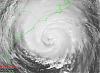
|
|
|
StrmTrckrMiami - the thunderstorm activity you're seeing is not associated with Fay. Fay is more than 400 miles away. The storms are part of the overall e-w synoptic flow, but IMO they are in not feeder-bands into the tropical cyclone.
| StrmTrckrMiami |
| (Weather Guru) |
| Sun Aug 17 2008 07:12 PM |
|
|
|
|
On Satellite it looks as though they are the feeder bands,.
http://www.winknews.com/
Check out the one that shows Fay and the one that shows florida..
|
MikeC
|
| (Admin) |
| Sun Aug 17 2008 07:47 PM |
|
|
The very latest GFDL shifted East again. I need to stop looking at the models now.
| StrmTrckrMiami |
| (Weather Guru) |
| Sun Aug 17 2008 07:49 PM |
|
|
|
|
Mike,
The models dont seem to know what they are doing for some reason.
| Hugh |
| (Senior Storm Chaser) |
| Sun Aug 17 2008 08:00 PM |
|
|
Quote:
The very latest GFDL shifted East again. I need to stop looking at the models now.
Last GFDL I saw was an eastern outlier already.... BAMM is really odd now.... calling for landfall in Tampa, and then turning around and heading for Pensacola.
Who's feeding the data into the computers, a sicko?
| LDH892 |
| (Meteorologist) |
| Sun Aug 17 2008 08:52 PM |
|
|
|
|
StrmTrckrMiami - I looked at the radar loop of the storms in your area earlier, and as I said above they are not feeder-bands. Feeder-bands are more developed linearly and are typically directly linked to pull moisture into the cyclone. Do a google search of feeder bands to find out more, or you can visit this site that I just found - link hope this helps.
| Addicted2Cane |
| (Verified CFHC User) |
| Sun Aug 17 2008 10:19 PM |
|
|
What?
| JMII |
| (Weather Master) |
| Sun Aug 17 2008 10:31 PM |
|
|
|
|
Quote:
Who's feeding the data into the computers, a sicko?
Garbage in / Garbage out
They can't get a fix on the center thus the models keep jumping around.Instead of looking at the storm itself I keep looking at the conditions in its general path. IE: what's going in NW FL, where is the High over the Atlantic, what about the low-level spin in the Gulf. Storms always take the path of least resistance, see where ever the clear "road" is thats were she'll go. Of course if you can't tell where she is currently that makes this whole process rather silly and pointless.
The models have moved west but I still see a general flow to the east. I just don't see how this storm can get that far up the state before being pushed aside by westerly flow shown in the water vapor loop: http://www.goes.noaa.gov/HURRLOOPS/huwvloop.html However the problem I see down the road is that since the storm has slowed down (again) it might just miss the big dip in the upper level over TN and sneak in behind it. The low pressure ahead Fay in the Gulf is dropping further south so its effects are being minimized with each passing hour, thus maybe she'll slide even further west, I wonder if this is what the models are grabbing onto.
Then again these effects are mostly pronounced on more vertically stacked and developed storms. The weaker Fay stays the harder it is to judge just what will effect her the most.
| scottsvb |
| (Weather Master) |
| Mon Aug 18 2008 12:43 AM |
|
|
Fay Forecast:
I'll go out on a limb and give my landfall forecast for Fay. (about 24-36hrs) from landfall as midnight Monday morning.
The models have been left and right. Only real model ( I hate to say ) that has been closest to being right is the CMC but along with the GFS. The CMC was first to say it would pass south of Hisapiola, then the GFS followed. The GFDL has been left and right along with the rest of the guidance and the Nogaps has been usually too far left (showing a weaker system generally). The CMC was most of the time on right side of the guidance for Florida, GFDL been next closest to it then the GFS with the rest of the spread generally along the west coast or in the eastern GOM. 0z data suggests more of a weakness in the northern gulf as a trough digs down. Also water vapor imagery also shows this, with a 2nd trough swinging in later tonight (Mondaynight), taking anything NE., and this will then discount the Nogaps model and shallow tropical model suites. The GFS suggest though along with the ECMWF that this trough will lift NE by Weds trapping FAY off the coast of Jacksonville then moving it back west later this week.
My forecast has to show a landfall from Marco island north to Sarasota.Although Fay does have a slight chance to make it closer to TampaBay the chance is less than 30%. Tampa will be forecasted to be brushed and get only a Tropical Storm warning.... another miss for this area.( Hurricane Wise)
Fay is still forecasted to become a hurricane but how strong it is matters on time over water and shear. I dont think the shear will be a major problem as she will move intandem with the shear zone. Most of the weather with Fay will be around and east of her. The water is very warm around 86-87F and I expect moderate strengthning Monday night into Tuesday approaching 85-95mph, could be more or less due to where it makes landfall and if it moves slow enough to be over the SE GOM for at least 24hrs.
After that being said.. that is my forecast for Fay and with anyone blogging info, take the NHC forecast over me or anyone else is who you go by.
Fay will move NNE-NE and exit later Tuesday night-Weds off Daytona-Jacksonville slowdown then from there its too early to say. As a ""guess"" ..Really folks it could wobble SE then S and West back towards NE Florida,GA going inland or even extreme NE Big Bend of the GOM later this week-weekend.
|
danielw
|
| (Moderator) |
| Mon Aug 18 2008 12:51 AM |

|
|
|
While I am not a MET.
I will attach the radar image that was being questioned as to whether it is a feeder band moving into the Ft Myers area at 2215Z Sunday.
http://i.flhurricane.com/images/BYX.N0Z.0808172213.912x684.none..70.gif
| StrmTrckrMiami |
| (Weather Guru) |
| Mon Aug 18 2008 12:55 AM |
|
|
|
|
Thank you for this, but where is Fay?
| allan |
| (Weather Master) |
| Mon Aug 18 2008 12:56 AM |
|
|
|
|
My forecast (at times, I do feel I'm overpowering it, yet I look at the past storms that have went through this area)
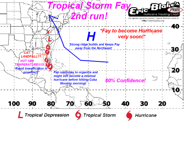
However, scottvbs forecast is good to.. yet he brings Fay right over me lol
| StrmTrckrMiami |
| (Weather Guru) |
| Mon Aug 18 2008 12:58 AM |
|
|
|
|
Does that say Cat 3 making landfall?
| scottsvb |
| (Weather Master) |
| Mon Aug 18 2008 01:05 AM |
|
|
That is his forcasted... Dont take mine , his or anyone elses over the NHC...
| allan |
| (Weather Master) |
| Mon Aug 18 2008 01:09 AM |
|
|
|
|
Like I said earlier, I might be overdoing the strength, so scottsvb is right, don't take mine for granted but I guess look at it like a model for right now.
| ftlaudbob |
| (Storm Chaser) |
| Mon Aug 18 2008 06:54 AM |
|
|
|
|
Just when I thought I was out of the woods.We should be back in the cone at 8:00,and the forecast track should shift even farther east.
Looks like Tampa misses another one.
| MichaelA |
| (Weather Analyst) |
| Mon Aug 18 2008 07:01 AM |
|
|
|
|
Until we get a reliable fix on Fay's location and strength, the models and forecast track/strength are going to be variable. I don't see a consensus developing until later today. I'm still leaning toward a NE or NNE track with landfall south of Tampa Bay. Of course, that's just my guess.
| ftlaudbob |
| (Storm Chaser) |
| Mon Aug 18 2008 07:25 AM |
|
|
|
|
On the 5:00 am update it has movement at NNW,so to me it looks like it's making that turn earlier than expected.
| willw |
| (Weather Watcher) |
| Mon Aug 18 2008 08:22 AM |
|
|
If you're watching...
http://radar.weather.gov/ridge/radar.php?rid=BYX&product=N0Z&overlay=11101111&loop=yes
or
http://www.wunderground.com/wundermap/?l...ur=0&fire=0
that's nnw ? If that's the eye coming off cuba.It looks NORTHWEST to me. But that's my naked eye opinion..
| Ed in Va |
| (Weather Master) |
| Mon Aug 18 2008 08:36 AM |
|
|
Lot of convection SE of Miami. Think there's any chance that the center will reform there?
| JMII |
| (Weather Master) |
| Mon Aug 18 2008 09:04 AM |
|
|
|
|
Fay got ripped apart, all the activity is NE of the center. She's got a very small window to get her act together, water vapor shows she is trying to wrap up but the squeeze play is on. Still not sure what the models were seeing yesterday that caused them to move west as the High in the Atlantic is breaking down, looks like she'll wobble or reform slightly NW of her current position then arch to the NNE. Landfall in the same area as Charley as Cat 1 is my call too. The structure is just not there (yet) for anything that strong. Plus the worst of the weather will be east over the FL Keys and Miami area regardless.
| JMII |
| (Weather Master) |
| Mon Aug 18 2008 01:56 PM |
|
|
|
|
Looks like Fay is NE of the NHC projections. At this point she looks to go slight east of Key West (thru Big Pine Key maybe), then make landfall around Naples as TS. Personally I don't think we'll even get to Cat 1 levels as currently the wind is only blowing at 40 mph in Key West. Just doesn't seem like she's got the time or upper level environment to build up to 75 mph within the next 24 hours.
Hope everyone remains un-FAY-zed by this sloppy storm
| Ed in Va |
| (Weather Master) |
| Mon Aug 18 2008 02:46 PM |
|
|
Agreed. I think the only chance Fay has to to strengthen significantly is to get to the Atlantic. Looks like the continued land interaction in the Gulf will not give any time for development.
We seem to have lost the graphics on 94L, but it's coming together. Looks more organized than Fay at this point:
http://www.ssd.noaa.gov/goes/flt/t2/loop-vis.html
| WeatherNut |
| (Weather Master) |
| Mon Aug 18 2008 06:19 PM |
|
|
I'd say this one 94L will be a TD very shortly if the convection that fired over the center can maintain with all the dry air in the area
| StrmTrckrMiami |
| (Weather Guru) |
| Mon Aug 18 2008 07:08 PM |
|
|
|
|
Quote:
I'd say this one 94L will be a TD very shortly if the convection that fired over the center can maintain with all the dry air in the area
Where is 94L?
| gatorman |
| (Verified CFHC User) |
| Mon Aug 18 2008 07:48 PM |
|
|
am i alone, it looks from radar that there isnt an eye yet(which would make this easier to spot) but looks to me Fay has almost a northwest movement?? maybe its wishful thinking, but see what yall think???
| Unregistered User |
| (Unregistered) |
| Mon Aug 18 2008 08:12 PM |
|
|
94L looks like it gettin its act together... its beginning to twist
| JMII |
| (Weather Master) |
| Mon Aug 18 2008 08:18 PM |
|
|
|
|
Fay is moving north and getting more organized. I predict a Naples landfall as a minimal Cat 1 around 5AM tomorrow. Just my $.02 which doesn't buy much these days
| johnnylightning |
| (Registered User) |
| Mon Aug 18 2008 08:34 PM |

|
|
|
My sister moved to Oregon after getting hit at Port Charlotte by Charlie. She said not to believe any forecasts until Fay had past . Cynical or smart?
| Orlandoman |
| (Registered User) |
| Mon Aug 18 2008 08:50 PM |
|
|
Mike...What is your take on Orlando, Will we get much wind and Rain...I am on the East side of town
|
MikeC
|
| (Admin) |
| Mon Aug 18 2008 09:35 PM |
|
|
Quote:
Mike...What is your take on Orlando, Will we get much wind and Rain...I am on the East side of town
I'm over by Universal, I expect it to be breezy and rainy, maybe a few gusts over Tropical Storm Force, but nothing too bad, assuming things don't change overnight.
| West FL Jess |
| (Weather Hobbyist) |
| Mon Aug 18 2008 09:42 PM |
|
|
|
|
do you think Tampa will get anything? 30MPH or 40MPH winds?? Where I live we flood after a good 10 min rain and everyone forgets how to drive so I can't imagine a few hours of rain...
| efaulkSWFLA |
| (Verified CFHC User) |
| Mon Aug 18 2008 10:04 PM |

|
|
|
Can anyone shed some light on what we can realistically expect in the S. Fort Myers/Estero area? Local Fox downplays the storm, Local CBS says prepare for possible hurricane conditions. Anyone?
| StrmTrckrMiami |
| (Weather Guru) |
| Mon Aug 18 2008 10:18 PM |
|
|
|
|
Quote:
Can anyone shed some light on what we can realistically expect in the S. Fort Myers/Estero area? Local Fox downplays the storm, Local CBS says prepare for possible hurricane conditions. Anyone?
I'm not a met by no means, but have been keeping a close watch on Fay. No one at this point really knows what to expect, but expect for the worst. I highly think Fay is capable of moving more then a high Cat 1 Hurricane, no more then a Cat 2. Currently, she looks to be trying to re organize herself again, much more organized then previous positions. She looks to be spinning like a hurricane and looks a lot healthier for hurricane conditions. Expect Fays bands to hit at 12:00am here in Lee County, with Naples being the first hit area. At 8:00am they expect Fay to be directly over us with her eye, meaning don't go outside. Not sure if they'll sound sirens or not. As far as weather, watch for frequent spawns of tornadoes Currently, Miami and Everglades show up for Tornado Warnings on Radar. Watch for Funnel Clouds, and the tornadoes over water. Expect Heavy Wind Gusts and downpours of rain. Frequent Lightning and Thunder. Current Radar: http://radar.weather.gov/radar.php?rid=BYX&product=NCR&overlay=11101111&loop=yes is where you can see all of Fay's energy. At the lease prepare for the worst. I know in Miami, some blown transformers caused power to be out, and so expect the power to go out. Careful and be cautious of downed electrical wires, and have lots of bottled water and food prepared as well as a first aid kit, and flashlights handy. When the time comes for the Military or FEMA or your Governor to tell you to go, go. Don't wait, go to a shelter.
Hope this helps in the slightest. This is the best advice I can give to anyone.
| JMII |
| (Weather Master) |
| Tue Aug 19 2008 08:56 AM |
|
|
|
|
Quote:
I predict a Naples landfall as a minimal Cat 1 around 5AM tomorrow.
TROPICAL STORM FAY ADVISORY NUMBER 15
NWS TPC/NATIONAL HURRICANE CENTER MIAMI FL AL062008
500 AM EDT TUE AUG 19 2008
...FAY MAKING LANDFALL AT CAPE ROMANO...
MAXIMUM SUSTAINED WINDS ARE NEAR 60 MPH
I was off by 20 miles and 15 mph, but got the timing just right. Looks like she sucked in too much dry air after that last flurry of convection in Florida Bay and thus never made hurricane status. After seeing only 50 mph winds in the Keys I knew the NHC forecast of Cat 1 wasn't likely. Also should have remembered that Marco Island sticks out into the Gulf and given Fay's track she would hit there BEFORE Naples.
I give the NHC a "B" on this one, considering how sloppy Fay was, with the center constantly relocating and the lack of access to Cuban air space they did a really good job. A touch too aggressive with the strength (which they tend to do as a CYA) and too far NW on the track up until the last 12 hours.
| MichaelA |
| (Weather Analyst) |
| Tue Aug 19 2008 10:07 AM |
|
|
|
|
We could be in for several days of soggy weather if Fay ends up meandering in North FL and South GA giving us a westerly wind flow off the gulf here in the Tampa Bay area.
| StrmTrckrMiami |
| (Weather Guru) |
| Tue Aug 19 2008 11:17 AM |
|
|
|
|
It appears that Fay has formed an eye while over the land of Florida. Can anyone confirm? I've got several places showing an eye that was forming, and an eye like structure that did form. Is this possible?
| Unregistered User |
| (Unregistered) |
| Tue Aug 19 2008 11:41 AM |
|
|
yeah i was wondering if we were going to get any rain. thus far none here in Parrish. is the eyewall formation due to the trough to the north?
| pcola |
| (Storm Tracker) |
| Tue Aug 19 2008 11:46 AM |
|
|
|
|
More than an eye, its the center of circulation. It is just more visible since rainbands have wrapped around it. Fay will hold its TS status for a good while, especially over south florida. The question will be what happens next and where it happens,. Will it stall over water and strengthen? Will it head west into the Gulf again and develope or over land north of the gulf? Big questions with very inconsistent models. It would not be uncommon for Fay to redevelope in the Atl or Gulf. Erin exited north of Tampa as a 40mph TS and almost made it to Cat 2 before hitting again in Pensacola in 95. We still have a bit of watching to do yet. Most models agree on a stall and then westward turn. The question is where.
| StrmTrckrMiami |
| (Weather Guru) |
| Tue Aug 19 2008 01:10 PM |
|
|
|
|
So you mean to tell me this is not just the eye of her? This is also the center of circulation? This is what is fueling her?
| Storm Cooper |
| (User) |
| Tue Aug 19 2008 04:57 PM |
|
|
An interesting portion of the AFD Tallahassee...
.LONG TERM...
(FRIDAY NIGHT THROUGH TUESDAY) THE 12 UTC GFS AND ECMWF HAVE
THROWN US YET ANOTHER CURVE BALL AS THEIR LATEST SOLUTIONS TAKE
FAY INTO THE NORTHEAST GULF BY THIS WEEKEND (AS OPPOSED TO A TRACK
ACROSS SOUTH GA AND SOUTH AL). THIS COULD ALLOW FOR RE-
STRENGTHENING DEPENDING ON HOW MUCH OF FAY SURVIVES HER TREKS
ACROSS THE STATE. THE ECMWF EVENTUALLY TAKES FAY INLAND OVER
SOUTHERN MS WHILE THE GFS TAKES FAY SLOWLY INLAND AROUND PANAMA
CITY EARLY NEXT WEEK. WE TOOK A BLEND OF THE THESE TWO SOLUTIONS FOR
THIS FORECAST PACKAGE. WITH EITHER SCENARIO WE EXPECT QUITE A BIT OF
RAIN...RANGING FROM 3 TO 5 INCHES WITH LOCALLY HIGHER AMOUNTS. OF
COURSE THE SLOWER GFS SOLUTION WOULD LEAD TO EVEN HIGHER AMOUNTS.
WE STILL HAVE NOT BEEN ADVERTISING MUCH OF A WIND THREAT...BUT IF
THESE LATEST MODEL TRENDS CONTINUE WE MAY START DOING THIS.
| Tammster |
| (Registered User) |
| Tue Aug 19 2008 05:18 PM |
|
|
I am completely unsure of what to do....
I have to be in Orlando at 8am for a pretty important conference & I'll be driving from West Palm Beach. My original plan was to take the turnpike & leave around 6 - 6:30. I was hoping that the eye would pass by the turnpike by then and that the backend wouldn't be so bad to drive through.
My husband is trying to convince me to wait until morning but I'm concerned that the storm (which may be a hurricane in the morning) may turn back toward florida more south than what is now forecast (per the 5pm discussion). It seems like it may be worse weather in the morning up that way than it will be tonite.
What are your thoughts on this??? I keep watching the radar willing the eye to move faster but if anything, the storm seems to be stretching out more.
(sorry if this is not the correct forum for this... feel free to move this if appropriate).
Tammy in West Palm Beach
| Storm Cooper |
| (User) |
| Tue Aug 19 2008 05:36 PM |
|
|
That is a very "iffy" question right now. Given the distance of the center of Fay to Orlando...about 82 miles +/- there is not much room for any track shift not to have an impact one way or another. I would stick with the NHC's track but up to 48 hours things may change a lot. In short I don't believe a sooner southward turn will occur but again the "iffy" factor.... Do you have the option of just saying that this conference may just have to be put on hold? Aside from your husbands that is my best advice.
| rayboat |
| (Registered User) |
| Tue Aug 19 2008 05:37 PM |
|
|
Make a phone call to your Orlando party and explain your situation to the if you haven't already. There are probably a few other people in the same conundrum. Fay looks to be a Hurricane tomorrow. I would postpone any travel which heads in that direction. If it were in Key West there would be much less of a problem. At any rate be SAFE!
| Tammster |
| (Registered User) |
| Tue Aug 19 2008 05:52 PM |
|
|
In this case, I'm the only Floridian... everyone else has alledgedly arrived more or less on time since the airport delays weren't awful.
In any case, I have the option of now driving to Pt St Lucie to stay the night. I can then get up early & see what the radar looks like.
I appreciate your input... thanks!
| watchinout |
| (Verified CFHC User) |
| Tue Aug 19 2008 05:56 PM |
|
|
I'm just trying to put 2 and 2 together here but Fay has increased in strength over land made a fairly nice looking eyewall will reenter warm ocean water around midnight spend what looks to be like about 36 hrs. in the Atlantic and possibly hit Florida again around St. Johns or Flagler County. I don't live far from there and i'm wondering how big yall think this storm can get.
That is up in the air....follow the NHC as they update their forecasts...
| OrlandoDan |
| (Weather Master) |
| Tue Aug 19 2008 06:57 PM |

|
|
|
I just have not seen a substantial easterly component over the last couple of hours. Turn on Lat/Lon on the ssatelitte maps and you will see what I mean.
| pcola |
| (Storm Tracker) |
| Tue Aug 19 2008 07:01 PM |
|
|
|
|
latest gfs wants to bring Fay back into the Gulf....looks like the NHC is hinting at this as well...we could be dealing with this for 5-6 more days, or longer if that happens farther south
| Jester |
| (Registered User) |
| Tue Aug 19 2008 07:01 PM |
|
|
I don't post often, as a matter of fact I think this is my second post in about four years or so. I hope I'm in the right forum for this question. Being in the Tampa bay area it is understandable that I watched Fay with great interest. Long story short, the local mets have something called VIPIR that seems to have nailed Fays track down to the mile. Is this a fluke? The spaghetti plots were coming together towards landfall but VIPIR had the track all along.
Should I trust VIPIR?
Best,
J.
| Unregistered User |
| (Unregistered) |
| Tue Aug 19 2008 07:19 PM |
|
|
A local station in Orlando is saying the same thing. But trust is a strong word. Vipir got 2 tropical storms right and all the rest wrong. Not to good on Hurricanes. Trust the NHC when in doubt
| engicedave |
| (Weather Hobbyist) |
| Tue Aug 19 2008 07:27 PM |
|
|
Channel 9 (ABC) weather guy in Orlando, Tom Terry, says he doesn't think it'll make the Atlantic and he also said he doesn't think it'll track as far north as the NHC is forecasting
Moved to the Forecast Lounge
| Storm Cooper |
| (User) |
| Tue Aug 19 2008 07:30 PM |
|
|
Other than the Ask/Tell Forum I think you posted in the right place during this event. VIPIR is a radar/model product. Our local Met wxman007 can for sure fill you in as his station has VIPIR and he had a hand on its development. I believe it is a spin off of the AF MM5 model? You may want to PM Jason as I don't recall him speaking about VIPIR as forecasts goes.....too many models and too many solutions right now...
|
MikeC
|
| (Admin) |
| Tue Aug 19 2008 07:33 PM |
|
|
Comedy G F S Ensemble seriously, hey kids have crayons and draw yourself some model lines is what this looks like now.
The new GFDL, on the other hand keeps it over the Atlantic longer and then moves it in near Savannah, with the easterly trek that Fay seems to be having, this is a lot more likely than any of the GFS runs, (They mostly are already off)
I still think the NHC's track is the best bet for now.
| pcola |
| (Storm Tracker) |
| Tue Aug 19 2008 08:05 PM |
|
|
|
|
interesting that the gfdl for invest 94 shows Fay heading into the Gulf, and the gfdl for Fay shows a more north path..but the GFS ensemble seems pretty close as of now..should be fun to watch..nothing like the 5 day cone stretching from Bowling Green KY to 250 miles south of Pensacola........
(Post moved - Forecasts from long range models belong in the Forecast Lounge)
| wxman007 |
| (Meteorologist) |
| Tue Aug 19 2008 08:59 PM |
|
|
VIPIR is really two things. The software itself is a met data display platform...it was designed for the display of radar data originally, but was adapted for use with other datasets.
The VIPIR model is a custom version of the Penn State MM5 that has been modified by Baron Services, the group that created VIPIR. It has done very well with some storms, and not so well with others. It is a model, and all model data should be evaluated on a storm by storm basis...all of our forecast models have had good storms and bad storms.
| Jester |
| (Registered User) |
| Tue Aug 19 2008 09:19 PM |
|
|
This post was sent to the Hurricane Graveyard
| StrmTrckrMiami |
| (Weather Guru) |
| Tue Aug 19 2008 09:32 PM |
|
|
|
|
Okay, I have been gone for the last few hours and have come up with a few questions myself in regards to Tropical Storm Fay. Anyone can answer them, I just would like them confirmed.
1. Why is Fay Stationary? She is in the same exact place she was when I left at around 6:30pm EST. Is there a meteorological reason she is not going anywhere?
2. There has been some talk about Fay coming back toward us. What does this mean? Why would a Tropical Storm come back the way it entered? In this case, would she be much severe?
3. What are the chances of fay sticking around and the other Invest catching up to her? I know this sounds stupid on my part and all, but what is the likelihood of this happening?
4. Why are all of the weather plots just throwing Fay all over the place? Where does the NHC, UKMET and other data plotters or what ever you call them get their data from? How do they predict where the storm will be? Why are they changing so sporadically?
Lastly, what is Fay's overall plans? Things look like she is trying to strengthen but is having trouble doing so. She is defiantly one of my weirdest storms I've ever tracked, and quite interesting for my first storm. I have another thought on my mind. Why is is still Windy in Fort Myers? Were getting the same tropical conditions we have been getting all day. Wind Gusts are the same as they were when Fay was here. The rain has stopped since the sun went down. Any probable reasons for all of this?
(at this rate, I am going to expect the unexpected with Fay. She seems to be one of the wildest storms anyone has seen, and tracked. After all, she did strengthen over land, as well as form an eye that was visible on satellite imagery over land as well. I think I'm safe to say that no one is quite sure what to expect with Fay. Am I right in saying this?)
Thats it for now. I suppose.
| Unregistered User |
| (Unregistered) |
| Tue Aug 19 2008 09:37 PM |
|
|
Looks like Fay has taken a little jog to the east: http://radar.weather.gov/radar.php?rid=mlb&overlays=11101111&product=N0R&loop=yes
| mcgowanmc |
| (Weather Hobbyist) |
| Wed Aug 20 2008 08:40 AM |
|
|
I say it's sitting here.
All day.
Then moving W, maybe WNW.
Daytona gets 15".
Apalachicola Bay by Friday.
http://www.ssd.noaa.gov/goes/east/gmex/loop-wv.html
http://i.flhurricane.com/images/2008/clark6latest.png
Look at the cone of THC's forecast.
The weirdest TS ever. ;}
| Captain Jed |
| (Registered User) |
| Wed Aug 20 2008 09:07 AM |
|
|
Fay is a dud.I called it a fizzle/drizzle Sun 130 pm.Its never had any legs,cant get it together,just a nice rainmaker,which Okeeechobee needed,as well as the Glades/Central Fl.Its still just going to be a rainmaker for Fl.Scott svb as usual,in my opinion,year after year,nails them.
| Bad Zebra |
| (Registered User) |
| Wed Aug 20 2008 09:47 AM |
|
|
Wouldn't call it a dud where I'm sitting...trees down in Melbourne, scattered power outages throughout Brevard County. Several utility poles in the process of being replaced after being snapped. A good portion of my fencing is now layng on the lawn. Tornado ripped apart a manufactured home community Tuesday (surprise, surprise). and my pool's overflowing.
| Unregistered User |
| (Unregistered) |
| Wed Aug 20 2008 10:26 AM |
|
|
Any chance of percepitation and winds around hattiesburg ms?
Quote:
This is the "lounge" for 92L, the wave in the Central Atlantic. The place for just saying what you think. Don't take mine or anyone else's word for it here.
My guess is that whatever comes of 92L (if it develops or not) will remain mostly south (especially if it stays weaker now) and affect some of the islands and approach the Southeast or enter the Gulf at some point. It's the time of year where I start to take things like this a bit more serious, but any real discussion of it probably won't happen until we determine if it will form or not.
Interestingly the discussion for Houston this mornng mentions this system and they are curious to see if it'll enter the gulf.Quote:
LASTLY...THE TROPICS LOOK TO BE GETTING MORE ACTIVE. BOTH THE GFS
AND ECMWF ARE IN GOOD AGREEMENT WITH A SYSTEM APPROACHING FL/CUBA
BY AUGUST 19TH. CONDITIONS LOOK FAVORABLE FOR THE SYSTEM TO
DEVELOP. 500 MB FLOW SHOWS A BREAK IN THE RIDGE AND A WEAK TROUGH
MOVING ACROSS THE OHIO VALLEY. AT THIS TIME...THE SYSTEM LOOKS
LIKE IT`LL TURN TO THE NORTH OVER THE EASTERN GULF. BEARS WATCH.
| pcola |
| (Storm Tracker) |
| Wed Aug 20 2008 12:23 PM |
|
|
|
|
well if Fay is off the coast now, there is still the possibility of that 4th florida landfall if it re-enters the gulf at some point..that has to be a first
| Unregistered User |
| (Unregistered) |
| Wed Aug 20 2008 02:00 PM |
|
|
What are the local's 'gut' feeling about taking a booked vacation in Charlotte's Harbor next week or do I stay home in sunny CA? Have to fly through Atlanta, GA/Ft. Myers on 23rd & 30th...
| pcola |
| (Storm Tracker) |
| Wed Aug 20 2008 02:14 PM |
|
|
|
|
why not go..next week Fay will be far, far away........
| Captain Jed |
| (Registered User) |
| Wed Aug 20 2008 03:38 PM |
|
|
California-Cleared for a landing,come on in,its nice now!
| Robert |
| (Weather Analyst) |
| Wed Aug 20 2008 04:07 PM |
|
|
|
|
Well Gonna throw this out there for the short term. Fay sits sround breaking some florida rainfall 24 hour records. then the high coming digs south ahead fay forcing her into a Cyclonic loop probably a slight jog east followed by SE, WSW, W,WNW i will say it probably go's back in around vero to jupiter.
| Unregistered User |
| (Unregistered) |
| Wed Aug 20 2008 05:46 PM |
|
|
Capt. Jed-Your bio says resident sceptic, so if you think it's good to go, Cal. gals are coming...hope the storm brought lots of shells to shore, cause shelling & birdwatching is what I like to do. I appreciate the input.
| WeatherGeek |
| (Registered User) |
| Wed Aug 20 2008 06:02 PM |
|
|
Have been watching the radar out of Melborne, appears to be on a east jog...... watching the loop from 17:00 - 16:00...
| Captain Jed |
| (Registered User) |
| Wed Aug 20 2008 06:23 PM |
|
|
Cali-It was a good day to shell in PC when this"monster"came aboard.Its a mere windfield now....
| mbfly |
| (Weather Guru) |
| Wed Aug 20 2008 10:36 PM |
|
|
|
|
For what it's worth, this just in from a local weather service in my area...............
"Tropical Storm Fay is about 35 miles north of Cape Canaveral this evening. The storm has drifted slowly northward during the day and should soon begin a more northwesterly motion tonight. Fay will likely move inland tomorrow morning near the Daytona Beach/St. Augustine area.
Steering currents are virtually non-existent around Fay at the moment, but as high pressure strengthens to the north over the Mid-Atlantic states, Fay will be forced westward on Thursday and Friday and will move back across the Florida Peninsula. Fay has a good chance of reaching coastal areas of the extreme northeast Gulf of Mexico by late Friday and then should continue roughly parallel to the coastline of Northwest Florida on Saturday and Sunday. Fay will likely turn northward by late Sunday or Monday after possibly moving as far west as the Pensacola area or southwest Alabama.
As Fay moves westward during the next few days, it is very likely that the storm will remain too close to the Northwest Florida coast for significant strengthening to occur. Thus, Fay is expected to remain weak (tropical depression) as it moves westward this weekend. Also, Fay could easily remain slightly inland from the Northwest Florida coast, which would mean the storm would continually weaken over the weekend. There is only a 10% chance that Fay will move far enough offshore over the open waters of the northeast Gulf for the storm to strengthen into a strong tropical storm or hurricane this weekend.
Fay has already been a devastating flood producer with some locations in east-central Florida receiving over 25 inches of rain. Additional heavy rainfall amounts of 5-10 inches are likely over northern Florida during the next couple of days as Fay moves slowly westward. Additional local amounts may reach 15 inches. Much smaller rainfall amounts are likely in southern Georgia.
A tornado threat will continue over northeast Florida and southeastern Georgia tonight and Thursday.
Tides of 1-3 feet are likely occurring along the northeast Florida coast to the north of Fay's center, and these tides will continue into Friday morning. Significant beach erosion is also probably occurring."
| pcola |
| (Storm Tracker) |
| Fri Aug 22 2008 02:09 PM |
|
|
|
|
The 12z GFDL takes Fay along the coast, inland near al/ms, then back along the coast all the way to Texas. Both the CMC and GFDL have a very well defined tropical cyclone near western Cuba at the end of their runs, basically developing invest 94...looks like we will be busy for a while