MikeC
|
|
(Admin)
|
|
Fri Aug 14 2009 12:14 PM
|
|
|
|
|
|
|
|
 Bill Lounge Best Guesses and Long Range Models
|
|
90L is likely to become TD#3 today, and some of the long range models are interesting. It's the lounge category because these models tend to get wacky at long range. Anything you see here past 4 days or so probably will not happen, but it's interesting to note the trends from day to day on these.
It may get near the US around August 24th.
I'll do a model rundown here:
CMC -- Out 6 days, approaching Leeward Islands of the Caribbean.
GFDL - Approaching just to the north of the LeewardIslands.
GFS - Into Leeward Islands... Through Puerto Rico, clipping Hispaniola, through the Straights of Florida into the Gulf and into Louisiana. (Fantasyland at that far out)
Strength wise it may get larger, weaken somewhat and then fluctuate. If it gets in the Gulf all bets are off, if it stays east, then it'll likely run into more shear but still be fairly large.
At this point I would take the models with a huge grain of salt. Around 15N 50W is a good aim point to determine how likely the Leewards and Puerto Rico will see the storm. If it's south or just at that point, it'll be more likely for them to see something.
There are other indication that the ridge may weaken, which would open a hole for it to recurve. (EURO/HRWF) as well. So in short at that far out it is anyone's guess.
Otherwise there is a good week to 10 days to watch this system.
Into the Caribbean is also a possibility.
|
|
|
 Re: 90L Lounge Best Guesses and Long Range Models
|
|
I agree with the grain of salt. I looked as CMC and GFS last night and was a bit shocked to see how deep that system is predicted to become in about 5-7 days time!! Nice convergence in the forcast tracks for this far out. I would imagine this will change when data from closer in becomes available. Some even show a pretty solid system following this one. Been nothing to cool the waters down so far, so anything is possible. Haven't been watching here much so far this season, but it looks like now is the time. Keep us informed!
|
|
MikeC
|
|
(Admin)
|
|
Fri Aug 14 2009 04:37 PM
|
|
|
|
|
|
|
|
|
Re: 90L Lounge Best Guesses and Long Range Models
|
|
12Z GFS now has 90L moving through the northeast Caribbean and then into the tip of S. Florida up along the western side of the state. It's not doing much except playing with the nerves at the moment. The consensus of all the models in the short term is pretty interesting though. Long term, I still don't buy it.
|
|
ftlaudbob
|
|
(Storm Chaser)
|
|
Fri Aug 14 2009 04:59 PM
|
|
|
|
|

|
|
|
Re: 90L Lounge Best Guesses and Long Range Models
|
|
Quote:
12Z GFS now has 90L moving through the northeast Caribbean and then into the tip of S. Florida up along the western side of the state. It's not doing much except playing with the nerves at the moment. The consensus of all the models in the short term is pretty interesting though. Long term, I still don't buy it.
Maybe it's just my eyes,but it looks to me like it has it going more up the east coast or middle of Florida.
|
|
|
|
Re: 90L Lounge Best Guesses and Long Range Models
|
|
well, apparently, all the model plots are comfortable with this thing coming to florida long term. since this is best guesses, im going to give my best guess. cat 2 hurricane. impact on broward county nw through the west coast of florida and a shimmy of a recurve past the carolinas into the hurricane dumpster.
|
|
MikeC
|
|
(Admin)
|
|
Fri Aug 14 2009 06:46 PM
|
|
|
|
|
|
|
|
|
Re: 90L Lounge Best Guesses and Long Range Models
|
|
GFDL is tow taking into the eastern Caribbean. Still much ado about nothing until 90L has formed solidly.
|
|
|
|
Re: 90L Lounge Best Guesses and Long Range Models
|
|
yeah you have to admit though mike, it looks preety impressive at this point. im thinking its only a matter of a couple days before it becomes a cane. although thats a best guess i suppose it depends on that system that sheared 2.
|
|
MikeC
|
|
(Admin)
|
|
Fri Aug 14 2009 06:50 PM
|
|
|
|
|
|
|
|
|
Re: 90L Lounge Best Guesses and Long Range Models
|
|
Oh it's definitely impressive for now, I'm just not trusting the models currently.
|
|
|
|
Re: 90L Lounge Best Guesses and Long Range Models
|
|
the long range models? i wouldnt either. i learned that mistake last season lol. i usually wait till its about 1200 miles from the east coast of florida before i start believing those models.
|
|
saluki
|
|
(Weather Hobbyist)
|
|
Fri Aug 14 2009 07:20 PM
|
|
|
|
|
|
|
|
|
Re: 90L Lounge Best Guesses and Long Range Models
|
|
I don't put much stock in those scary models this far out (that's not to say I don't look at them, of course), especially with 90L still in its formative stages. It certainly has the potential to make us nervous toward the latter part of next week, but so many conditions can change between now and then.
|
|
|
|
Re: 90L Lounge Best Guesses and Long Range Models
|
|
thats true, overall, i think we are looking at our first cane. and i think thats whats sparking these models up. its fairly impressive at its current stage.
|
|
weathernet
|
|
(Storm Tracker)
|
|
Fri Aug 14 2009 08:45 PM
|
|
|
|
|
|
|
|
 Re: 90L Lounge Best Guesses and Long Range Models
|
|
Well, ok....., i'll play. Though the limb that i'll crawl out on right now will remain a rather short 60hr.  one. one.
Overnight this evening ( Fri ), we'll see "ex-02" maintain its overall structure, and continue to fight off slowly ( and slightly decreasing ) easterly shear. Banding features to become a little more distinct. Tomorrow ( Sat. ) will see even less westerly displacement of convection, and getting close to reclassification to depression #2. With loss of sunlight, and perhaps waning diurnal convection...., NHC will hold back from "pulling the trigger" and await first vis. satellite on Sunday a.m. Bursting pattern and lessening shear will lead to system being upgraded right to T.S. on Sunday.
Meanwhile 90L, which despite strong easterly shear, continues to organize and despite some dry air being entrained by its own large envelope system, will continue to organize slowly overnight. Tomorrow ( Sat. ), organization will be evident, but outside of cycles of convective bursting, most convection will be within banding features. NHC ponders consideration to upgrade to depression #3 during the day, but holds off. During Sat. evening, maintained banded convection near the center along with surface ship reports reporting seagulls off the starboard bow - flying backwards. Though the 8:00pm T.W.O. just released, Ships report prompts late evening Special Tropical Advisory & NHC upgrade 90L to Depression #3.
First visable satellite prompts immediate decision to upgrade both systems to Tropical Storm strength, however decision must first be made which name ( Ana or Bill ) to be tagged, to which storm. That, and given persistant 90L HWRF/GFDL intensity forecasts, which name would they prefer to retire given the choice.
|
|
MikeC
|
|
(Admin)
|
|
Fri Aug 14 2009 10:25 PM
|
|
|
|
|
|
|
|
|
Re: 90L Lounge Best Guesses and Long Range Models
|
|
18Z GFS is further south than the earlier one. Into the Caribbean and going over Hispaniola. This jives with the GFDL going further west too. 90L could wind up being one of those systems that keeps heading westward if the trend continues. I'll check again in two days to compare it.
Activity Behind 90L is interesting too.
|
|
|
|
Re: 90L Lounge Best Guesses and Long Range Models
|
|
yeah mike, there are some models that show flare up of 2 other systems behind 90l isnt there?
|
|
MikeC
|
|
(Admin)
|
|
Sat Aug 15 2009 11:52 AM
|
|
|
|
|
|
|
|
|
Re: 90L Lounge Best Guesses and Long Range Models
|
|
Latest GFS stalls the storm off the Southeast coast of Florida, GFS is still unreliable that far out.
With Ana and 90L following a similar track with the models, we could have storm scares back to back in Florida. I doubt both would hit, but it's seems likely at least one of the two will. I just hope they remain weak and the El nino westerly shear comes to tear them up at some point.
The thought of a double hit on Florida is disturbing, they would be mere two-3 days apart if the worst case were to happen.
|
|
|
|
Re: T.D. #2 - ......it's back again
|
|
All of sudden I have Bill Chill in Brevard. I would love to pick Clarks brain on this system. A shift to the left by 11pm or 5am tomorrow?????
(Post moved to a more appropriate Forum.)
|
|
Johncn
|
|
(Registered User)
|
|
Sat Aug 15 2009 10:57 PM
|
|
|
|
|
|
|
|
|
Re: 90L Lounge Best Guesses and Long Range Models
|
|
Just got a name....Bill...let's hope it doesn't live up to the major storm predictions.
My place is in Cape Canaveral, and I've just discovered this forum. Got done putting my boat in the Cape Marina inside storage today and discovered that Ana was not alone on the list of named storms so far this year.
Nice to know you guys are here. Does the board get pretty active during the season?
Johncn
|
|
|
|
Re: 90L Lounge Best Guesses and Long Range Models
|
|
yes we get active come this time of year. while this isnt an official source (it should be) everyone here gets together and grinds their skulls to figure out best guesses and formulate general opinions to help give everyone an idea of how things will be. its without the hype.
i noticed something though. that nhc forecast from the previous advisory to this advisory shifted south to the keys. i wonder if thats going to become a normal trend for ana. and bill, i wonder if bill will follow the same path. while we should watch both closely its bill im concerned with. ana looks to be something similar to another fay perhaps. very small in size. a rain maker. ill be curious to see how bill shapes up. the intensity plots have been preety tight in the past couple of days for bill.
|
|
Johncn
|
|
(Registered User)
|
|
Sat Aug 15 2009 11:51 PM
|
|
|
|
|
|
|
|
|
Re: 90L Lounge Best Guesses and Long Range Models
|
|
Thanks for the reply.
I'm hoping that similarities to David (1979) are only superficial, as I'm not really all the knowledgeable about the forecasting models.
Regards,
Johncn

|
|
|
|
Re: 90L Lounge Best Guesses and Long Range Models
|
|
well the latest spaghetti plots for bill seem to do a 180 from what they were earlier today. same with ana.
|
|
Johncn
|
|
(Registered User)
|
|
Sun Aug 16 2009 03:14 AM
|
|
|
|
|
|
|
|
|
Re: 90L Lounge Best Guesses and Long Range Models
|
|
Yep. Excellent. Curving more northerly (except the UKMET), and a much better looking result for us. Thanks.
Johncn
|
|
Hurikid
|
|
(Verified CFHC User)
|
|
Sun Aug 16 2009 12:38 PM
|
|
|
|
|
|
|
|
|
Re: 90L Lounge Best Guesses and Long Range Models
|
|
Is it just me or does the 06Z GFS run put Bill as a major hurricane heading directly torwards New York City?
|
|
ftlaudbob
|
|
(Storm Chaser)
|
|
Sun Aug 16 2009 04:15 PM
|
|
|
|
|
|
|
|
|
Re: Bill lounge. Where is will go? Models and Best Guesses
|
|
Bill continues to look good,very good.Yesterday most of the models had it going very different than they do today.So now we will see what they do over the next few days.Look how the models changed in just 24 hours.A lot going on,a lot to watch.
I am thinking maybe Wednesday we will have a better handle on where Bill is going.
|
|
weathernet
|
|
(Storm Tracker)
|
|
Sun Aug 16 2009 04:56 PM
|
|
|
|
|
|
|
|
|
Re: 90L Lounge Best Guesses and Long Range Models
|
|
Am fascinated how the European model ( often one of the more respected ), had forecasted yesterday a much more "poleward" track than nearly all other models. In fact, given the GFS 500mb data, I would have bet my last dollar that at minimum, this storm would have a 270 degree motion for at least 48 hours. Heck, what would seem to be quite a respectible 594mb heights at the mid levels, would seem to prevent any temporarty change in latitude. Naturally, the orientation of any mid level troughs or high pressure ridges have as much to do with overall motion as well. Here is where the data as we see it reported and spit out by computers, is so important. Forget 7-10 day forecasts, so much importance exists simply for accurate current analysis.
So much for my meteorological diatribe on the importance for proper funding towards the necessary tools to aquire more thorough and accurate data, thus to aid and advance the science of meteorology....
As Bill continues to deepen, I can only imagine that any low level steering influence would become fully irrelevent, and that most models would have a much better handle on future motion. Of course, this has now occured, and much more confidence exists today, than yesterday. This said, is New York or other points on the E. Coast out of the picture yet? I would say no. Recent patterns across the Conus, would seem to have more cut off lows dropping out of Hudson Bay, but only to drop south a little, and then get caught up in a fairly progressive westerly flow. This flow has been shunted fairly north, and there have been less hanging troughs off the Eastern seaboard than in numerious other years. Timing is everything, and Bill could eventually go through substantial deepening and slow down a little, or maintain a slightly more westward track than forecast due to its relative larger size. Point being, that if a weekness does in fact cause Bill to move more northwestward towards the later end of the forecast, if such a weakness pulls up fairly quickly, and strong ridging builds ( or bridges ) over the western Atlantic, than a bend back towards the WNW could ensue. All the more reason that the entire Eastern seaboard need pay attention.
Way to far out for anyone to have much confidence in any forecast. For the moment, my best guess would be a bend back towards the Carolina's. No doubt, i'll be paying a bit more attention to the Euro long range, than most of the other models with this one.
|
|
MikeC
|
|
(Admin)
|
|
Sun Aug 16 2009 07:15 PM
|
|
|
|
|
|
|
|
|
Re: Bill Lounge Best Guesses and Long Range Models
|
|
The GFS today has Bill recurving out to sea, never making landfall as well as whatever forms behind it.
|
|
ftlaudbob
|
|
(Storm Chaser)
|
|
Sun Aug 16 2009 07:31 PM
|
|
|
|
|
|
|
|
|
Re: Bill Lounge Best Guesses and Long Range Models
|
|
Quote:
The GFS today has Bill recurving out to sea, never making landfall as well as whatever forms behind it.
That would be great news!
I am just waiting to see if that changes by say Wed or Thur.
|
|
Hurikid
|
|
(Verified CFHC User)
|
|
Sun Aug 16 2009 08:28 PM
|
|
|
|
|
|
|
|
|
Re: Bill Lounge Best Guesses and Long Range Models
|
|
Bill looks VERY impressive on satellite now......Hurricane at 5 o clock?
|
|
MikeC
|
|
(Admin)
|
|
Wed Aug 19 2009 01:19 AM
|
|
|
|
|
|
|
|
|
Re: Bill Lounge Best Guesses and Long Range Models
|
|
Bill is now a Category 3 hurricane. The most likely scenario is still a recurve, but it's worth watching to see if anything changes.
|
|
|
|
Re: Bill Lounge Best Guesses and Long Range Models
|
|
yeah i agree, anything can happen. im just still waiting for that nothernly turn already.
|
|
MichaelA
|
|
(Weather Analyst)
|
|
Thu Aug 20 2009 02:42 PM
|
|
|
|
|

|
|
|
Re: Bill Lounge Best Guesses and Long Range Models
|
|
The most recent model runs seem to be tending a bit more westward bringing Bill very close to Cape Cod. If I were there, I'd be beginning preparations for the worst case scenario. Waiting until Saturday is not an option.
|
|
doug
|
|
(Weather Analyst)
|
|
Thu Aug 20 2009 06:13 PM
|
|
|
|
|
|
|
|
|
Re: Bill Lounge Best Guesses and Long Range Models
|
|
You may be correct. It will not take too much of a deviation west to place eastern NE in Jeopardy. The forward speed is already 18 and once the turn occurrs that will increase too. Wasn't it in 1936 or so when a massive cyclone came from nowhere to hit Long Island Rhode Island and Mass.? I think it took about 18 hours to clear from the Bahamas to land fall
|
|
Ed in Va
|
|
(Weather Master)
|
|
Thu Aug 20 2009 06:33 PM
|
|
|
|
|
|
|
|
|
Re: Bill Lounge Best Guesses and Long Range Models
|
|
The infamous LI Express, moving at 70 mph
http://www2.sunysuffolk.edu/mandias/38hurricane/weather_history_38.html
|
|
doug
|
|
(Weather Analyst)
|
|
Thu Aug 20 2009 07:27 PM
|
|
|
|
|
|
|
|
|
Re: Bill Lounge Best Guesses and Long Range Models
|
|
FYI just watched the latest Bastardi video that contained his forecast. He is on the left side of the current forecast track and used the analogs of the synoptic features that influenced Edna in 1954 as his guide. Thought you would appreciate that Ed since Edna is one of your reference storms.
|
|
Ed in Va
|
|
(Weather Master)
|
|
Thu Aug 20 2009 07:36 PM
|
|
|
|
|
|
|
|
|
Re: Bill Lounge Best Guesses and Long Range Models
|
|
Thanks...Edna's track http://commons.wikimedia.org/wiki/File:Edna_1954_track.png . Look about 300 miles east of Bill's projection.
I was only 4 that year, but was told the local expression is Maine , in 1950's jargon, was "Carol was a lady, but dig that Edna!" My only recollection from one of the storms, probably Edna, was watching a huge tree fall. I never saw another fall until Isabel, when a number of them went down in my neighborhood.
|
|
ftlaudbob
|
|
(Storm Chaser)
|
|
Thu Aug 20 2009 07:38 PM
|
|
|
|
|
|
|
|
|
Re: Bill Lounge Best Guesses and Long Range Models
|
|
The track for the 1938 hurricane.
[image]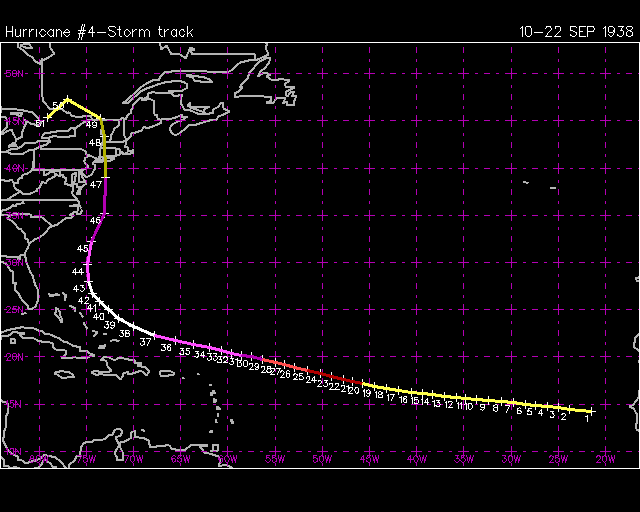 [/image] [/image]
|
|
doug
|
|
(Weather Analyst)
|
|
Thu Aug 20 2009 07:41 PM
|
|
|
|
|
|
|
|
|
Re: Bill Lounge Best Guesses and Long Range Models
|
|
Looking at that track, good ole bill will have to track well inside 70W to duplicate that scenario, or stay on 70 and be going north...He is at about 63 W now and the official track keeps it at 69.5 W or so...next 12 hours should tell us a lot.
|
|
MikeC
|
|
(Admin)
|
|
Thu Aug 20 2009 08:23 PM
|
|
|
|
|
|
|
|
|
Re: Bill Lounge Best Guesses and Long Range Models
|
|
Here's a link to the data here at this site with all 2 of those storms plus bill on there.
|
|
Ed in Va
|
|
(Weather Master)
|
|
Thu Aug 20 2009 08:30 PM
|
|
|
|
|
|
|
|
|
Re: Bill Lounge Best Guesses and Long Range Models
|
|
Good graphic. Bill is quite a bit to the east of the other two and we're light years past '38 and '54 in being able to forecast tracks. There is no practical reason to doubt the NHC projection.
|

