| cieldumort |
| (Moderator) |
| Tue May 31 2022 09:20 AM |

|
|
|
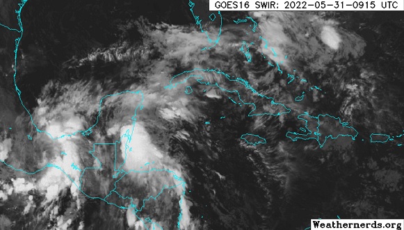
A broad and complex region of low pressure and disturbed weather presently over Yucatan/Belize to Chiapas/Oaxaca is associated with winding down former Hurricane Agatha coming northeast out of the far eastern Pacific interacting with diffuse remnants of a Central American Gyre and an approaching surface trof.
While this somewhat soupy concoction may start out a mess, odds favor organization throughout the new week, and at least one Tropical Cyclone is expected to emerge within a few days (presently 60% NHC odds as of this entry) in the western Atlantic. There is also a long shot Agatha retains her name, but this is less likely given the rugged mountains of Mexico and the significant interaction with the other players outlined above.
This region has not yet been Invest tagged, but will likely be designated 91L, barring the less probable outcome of Agatha holding together. Given the likelihood of development within 72 hours, we are starting a lounge on this well-advertised system now.
Models generally want to ramp the forecast tropical cyclone up, and run it near or across Florida and then up the Gulf Stream and/or out to sea.
The following are some 0531 0z Run summaries:
GFS - Two and possibly three systems. At least one short-lived TD or weak TS in the Bay of Campeche until dissipation Friday. New system (TD or TS) emerges between northern Cuba and the Keys Friday night, crossing the Bahamas as a TD or TS Sat/Sun and heads out to sea.
ECMWF - Strengthening Tropical Storm crossing S. Florida over the coming weekend. Cat 1/2 hurricane passing east of the OBX Monday.
HWRF - Appears to retain enough of Agatha as to reform a center in the extreme southwestern Gulf of Mexico, and keeps it in this region until landfall this coming Friday along the coast in the southern Bay of Campeche.
HMON - Begins exiting the Bay of Campeche, on a northeasterly heading, by this coming weekend as a Tropical Storm
Title Updates:
The broad low pressure we have been tracking that is partially made up from remnants of east Pac Agatha has now been Invest tagged, 91L, and the title of this Lounge has been updated accordingly. 6/1/22
Advisories are being issued on Invest 91L by 5PM today, June 2. While not yet a TC, the Hurricane Center has opted to use the Potential Tropical Cyclone designation, as tropical storm conditions on land are expected within 48 hours. The title has been updated accordingly. 6/2/22
PTC 1 finally organized into a bona fide tropical cyclone predawn Sunday June 5, east of Florida, and is, at long last, Alex. 6/5/22
| MichaelA |
| (Weather Analyst) |
| Tue May 31 2022 12:40 PM |

|
|
|
It looks like, to me, the ECMWF and the NAVGEM are a bit over aggressive while the GFS may be under aggressive at this point. Until the models have a better input, there will be widely different results. I look at FSU Ensemble
| IsoFlame |
| (Weather Analyst) |
| Tue May 31 2022 03:01 PM |

|
|
|
If the LLV can catch up with convection firing and starting to band over Bay of Campeche's 83F SSTs, then avoid (for a minimum of 24-hrs) significantly interacting with the Yucatan Peninsula, I believe post-Agatha's trans-Mexico circulation could become PTC or TS Alex sooner than models currently forecast:. GOES
| OrlandoDan |
| (Weather Master) |
| Wed Jun 01 2022 04:23 PM |

|
|
|
Do I see a slight shift north/west in the latest GFS run?
| Bloodstar |
| (Moderator) |
| Wed Jun 01 2022 06:07 PM |

|
|
|
Well, this year didn't have a preseason storm, but it sure looks like we have a shot at a June TC. In fact, looking at visible Satellite imagery, the LLC looks very closed and there is a decent chunk of convective cloud (-60 and colder) tops over the LLC. While there is shear around the system, It looks like the LLC is currently in a region of low shear along the entire atmospheric column.
A ton of moisture, low shear, and an established LLC? yeah, I think we will see a TC designated by tomorrow morning.
| Kraig |
| (Weather Hobbyist) |
| Wed Jun 01 2022 06:57 PM |

|
|
|
Looks like a a closed low has formed around 20N85W based on low level cloud flow. This is further east than expected in an area of even lighter shear so we may see it become a TS by 5pm as it could be argued a TD now. The location further east may bring the storm closer to the Keys than the models are currently showing. Here we go!
| cieldumort |
| (Moderator) |
| Wed Jun 01 2022 08:26 PM |
|
|
|
|
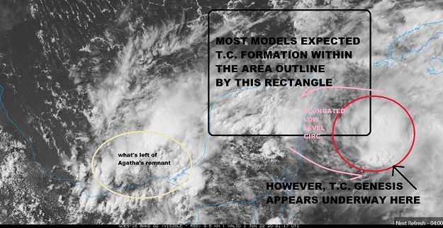
It does look as if Agatha gave up the ghost and yielded almost entirely to the trof that was hugging the coastlines of Belize and eastern Yucatan the past few days, now the location of 91L. What is left of Agatha has mostly been swallowed up by it, save a weak bit of swirl still over the southern Bay of Campeche.
As noted, 91L continues to organize east of its forecast position, and continues to track further to the right, with a stout mid-level center tugging at the surface trof that was off the coast of Belize, aligning it, and Tropical Cyclogenesis may already be underway.
Models that anticipated genesis about the tip of the Yucatan have possibly made a bad call. Recon's data tomorrow will be helpful, although PTC or TC advisories could already be issued by the time they arrive.
This probable initiation that is east-southeast of where anticipated will likely have some influence on future forecast track and intensity, and interests in the northwest Caribbean to Cuba to the Bahamas may also want to pay close attention tonight.
| cieldumort |
| (Moderator) |
| Thu Jun 02 2022 12:15 AM |
|
|
|
|
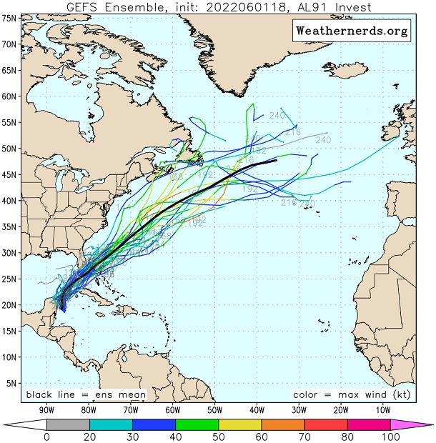
Above: 060118z GFS ensembles. Image cr. Weathernerds.org
The 18z GFS ensembles overall seem to have a much better handle on a more easterly starting position.
Taking a bird's eye view of things, the shift east from other, earlier model runs doesn't change the longer range forecast all that much, as there is consensus on taking whatever 91L is or becomes, north, before veering northeast, such that South Florida would still get a lot of weather, regardless. It just might have more bearing on how much of the state, as well as other locations like Cuba and the Bahamas, see inclement weather.
| JMII |
| (Weather Master) |
| Thu Jun 02 2022 03:36 PM |

|
|
|
Quote:
such that South Florida would still get a lot of weather, regardless.
The band of rainfall could be more thru the Keys vs S FL if this trend to the E continues. This is almost off the charts levels of rain from this tropical addition to the standard summer-time afternoon pop-up thunderstorms we get.

| OrlandoDan |
| (Weather Master) |
| Thu Jun 02 2022 04:56 PM |
|
|
|
|
The latest IR satelitte pic shows explosive convection.
| Lamar-Plant City |
| (Storm Tracker) |
| Thu Jun 02 2022 07:00 PM |

|
|
|
So, If it strengthens more than forecast, will that bring it farther north or push it farther south...I know the general rule for later season storm coming from the west, but have no idea what happens with one like this coming from the west...
| cieldumort |
| (Moderator) |
| Thu Jun 02 2022 07:33 PM |
|
|
|
|
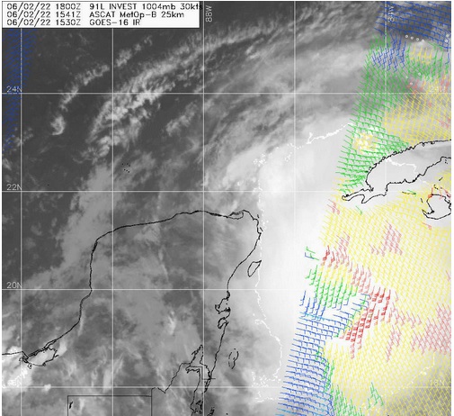
Above: Invest 91L ASCAT 06-02-22-1541z
Recon is presently rounding the northern tip of the Yucatan, checking out the low level circulation center of the broad circulation, which is inland over northern Yucatan. That is the surface trof from days ago, that looked a bit formidable even as Agatha was starting to push inland over southern Mexico, and that is now interacting with what is left of Agatha's old mid-level spin.
However, the newer surface spin that began developing underneath the deeper convection to the east of the trof hugging the Yucatan several of us were noting yesterday afternoon (see above), still appeared intact as of just a few hours ago, as can be gleaned from the ASCAT pass from 1541z.
So, 91L remains a bit of a jumbled mix. Fortunately, we can now look forward to recon data shedding more light on which 'center' is more dominant, more likely to become dominant, or even perhaps neither.
| cieldumort |
| (Moderator) |
| Fri Jun 03 2022 06:28 AM |
|
|
|
|
The broad center NHC has been focusing was not able to finish merging with the deep convection to its east. The secondary LLC that was associated with that deep convection has appeared to track NNE, and as per earlier GFS ensembles, indeed coalescing with the trof to its west, with a more robust and durable LLC just off the northeast tip of the Yucatan dominant and possibly now organized enough to classify.
Recon is finding some winds of tropical storm force, so PTC could go straight to Alex by the next Advisory.
| Prospero |
| (Storm Tracker) |
| Sat Jun 04 2022 12:37 AM |
|
|
|
|
Will it get a name?
Feeling it here in Gulfport. Nice breeze from a system. We may barely see any rain from this. But a nice way to start the season.
Wishing for a name.

| Kraig |
| (Weather Hobbyist) |
| Sat Jun 04 2022 03:25 PM |
|
|
|
|
No name unless it gets it together as a fish storm. With a couple hours to go, I've had about 4.5" of steady rain with no ponding so it was needed. I've currently got 1005mb and the "core" for a lack of a better term will track over me within an hour and my highest wind today was around 2am at 7mph! The southern tip of the state has been very dry with numerous wildfires and open burning restrictions, which I am sure are now history. A well timed rain event that many here are thankful for....