| cieldumort |
| (Moderator) |
| Fri Aug 12 2022 05:00 PM |

|
|
|
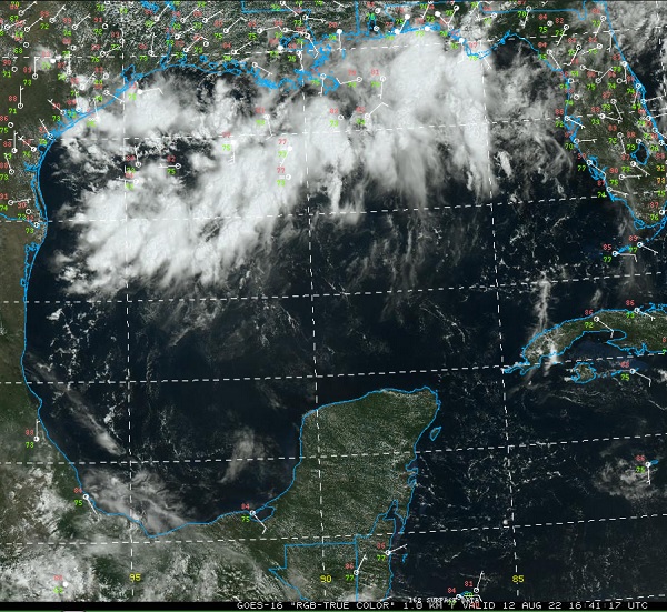
Visible with surface wind plots. 8-12-22 1641z Image credit: College of DuPage
An area of concentrated low pressure forming along a trough in the northern Gulf of Mexico we have been monitoring is showing increasing signs of organization and could very well already have better odds than model guidance and indeed the official NHC 10% of becoming a TD or named storm. Given its extremely close proximity to land, despite its low official odds and lack of an Invest tag at the moment, we are now starting a Forecast Lounge on what will likely be Invest-tagged soon if trends continue.
The trof we have been tracking has just been Invest-tagged 98L and the title is updated accordingly -Ciel
| cieldumort |
| (Moderator) |
| Fri Aug 12 2022 06:08 PM |
|
|
|
|
2PM NHC TWO keeping development odds at 10% for now and no Invest tag, yet.
There have been several marginal-TD/TSs that have formed close to land this year, some likely candidates for inclusion during post-season review. This feature could very well end up being like that. Alternatively, it may also come together obviously enough to be classified as a Tropical Cyclone in real-time. Either way, indications are that weather along the coast of Texas and then pushing inland are likely to at least resemble that of a TD.
As of 12Z the Globals, which do not have a very fine resolution, still insist on this casually coming ashore in Texas as an open wave or very weak low. However, CAMS, which by and large have done a much better job handling these hybrid, home-grown type systems so far this year, and also have a much finer resolution, do develop the low into a Tropical Storm over the weekend.
Here's some of the 12Z rundown
HRRR comes ashore between Rockport and Bay City late Sat. night/pre-dawn Sunday Tropical Storm, pushing inland
NAM3k comes ashore north of Rockport late Sat. night/pre-dawn Sunday Tropical Storm, pushing inland
ECMWF suggests it is starting to sniff something out
GFS open wave
GEM open wave
It is also worth noting that several of the EURO's ensemble members have taken notice. GFS, not so much.
Conditions in this part of the Gulf for development actually look pretty good and far better than the Atlantic has seen for many weeks. Time before coming ashore is limited however, and these home-grown systems can sometimes take too long to form before the clock runs out.