| cieldumort |
| (Moderator) |
| Wed Aug 23 2023 05:09 PM |

|
|
|
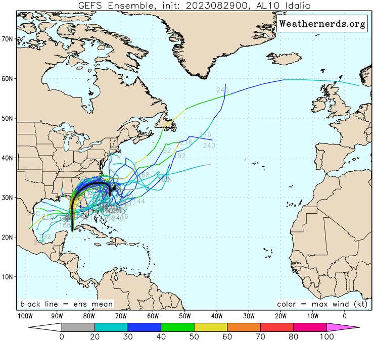
Increasingly, models are warming up to the idea of a tropical cyclone forming somewhere off Central America either in or moving into the Atlantic side later this week.
ECMWF ensemble implied formation probability is up around 65%. On the other hand, the operational runs of the ECMWF have been inconsistent, tending to keep this Low on the weak side and linger it around the Yucatan without much development, and the operational GFS washes it out over central Amerca by the weekend.
Overall, conditions remain favorable for tropical cyclone development in the Atlantic basin. Given this background state, model support and forecast locaton we are now starting a Lounge at this time on what is not yet Invest-tagged, but could be in a few days. Should this feature be assigned an Invest number the title will be updated.
There is a high chance that this well-forecast area of low pressure brings inclement weather to locations in and around the Western Caribbean to southern Gulf of Mexico, and based on modeling, a modest chance that it influences or impacts Florida by next week.
The area of interest in the northwest Caribbean has been assigned an Invest tag today, 93L, and the title has been updated accordingly.
TEN 8/26/23 5PM EDT - Ciel
| cieldumort |
| (Moderator) |
| Wed Aug 23 2023 07:21 PM |
|
|
|
|
23/12z Operational ECMWF has joined with so many of its ensemble members and develops. By the end of the day Friday, this model run shows a well-defined closed low established off the north coast of Honduras, tracks north to the northern portions of the Yucatan overnight Saturday as an apparent T.D. and very slowly drifts off the tip into the gap between Yucatan and western Cuba by Monday as a strengthening tropical storm, picking up speed later in the day Monday towards the north-northeast. Landfall Wednesday morning as a Cat 2+ hurricane near Bonita Beach, Fl.
| bob3d |
| (Weather Watcher) |
| Thu Aug 24 2023 04:39 PM |

|
|
|
I do not see how this potential disturbance can possibly wind itself up to a Cat 2+ hurricane with the amount of upper level sheer that the GOM is experiencing right now.
| cieldumort |
| (Moderator) |
| Thu Aug 24 2023 07:06 PM |
|
|
|
|
Here is the ECMWF model sounding forecast for shear over the vortext on Tuesday 8/29/21z. The high shear outside of the vortex is largely due to the upper-level outflow, which is favorable for strengthening. Right over the vortex, this model forecast anticipates low deep layer shear at this time (just 13 knots).
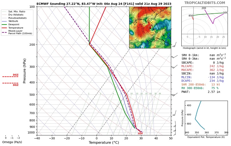
Graphic cr. TropicalTidbits
| cieldumort |
| (Moderator) |
| Fri Aug 25 2023 01:19 AM |
|
|
|
|

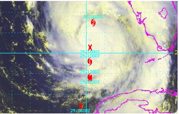
A small area of low pressure has formed in association with a quasi Central American Gyre. This compact area of low pressure is just off the northeastern tip of Honduras this evening, and is the most likely candidate swirl for initiation in the NHC 70% probability cone, although it may jump north to north-northwest in the shorter-term. Longer-term and overall, a motion to the north-northeast to northeast is largely anticipated by models as the low organzies and begins to round the base of a small upper-level low to its northeast (model differences remain on placements and interactions).
| cieldumort |
| (Moderator) |
| Fri Aug 25 2023 05:41 PM |
|
|
|
|
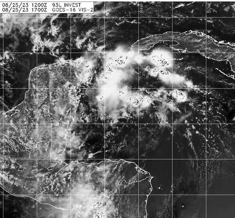
Above: 93L Visible 8/25/23/1700z
| OrlandoDan |
| (Weather Master) |
| Fri Aug 25 2023 07:36 PM |

|
|
|
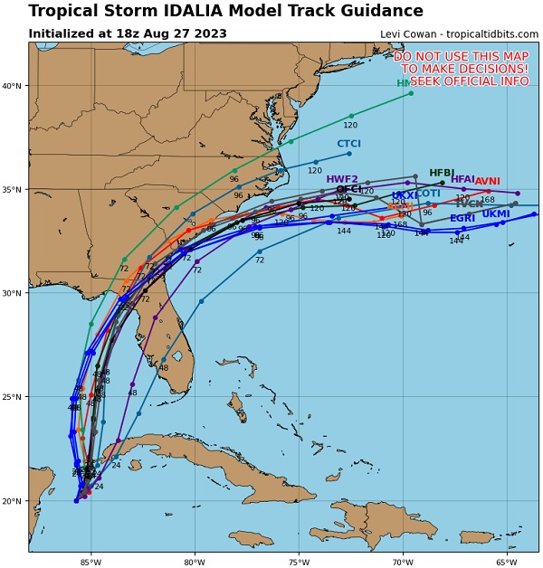
GFS and the Euro both are in agreement on the approximate path.
MikeC
|
| (Admin) |
| Fri Aug 25 2023 09:53 PM |
|
|
18z Icon shifted right to Sarasota (Was Steinhatchee at 12z) on Tuesday evening
12z Euro shows Strong TS/Cat 1 Landfall Cedar Key Wednesday morning.
12gfs shows a cat 2 into Panama City Beach on Wednesday morning
18gfs shows a cat 2 into Apalachicola midday Wednesday (a bit right of and later than 12z)
12z Ukmet shows a landfall on New Port Richey Tuesday night.
12z Canadian shows Cat1 landfall near Apalachicola.
|
MikeC
|
| (Admin) |
| Sat Aug 26 2023 01:36 AM |
|
|
Hurricane models
18z HMON cat 2 landfall just east of Apalachicola early Wednesday morning
18z HWRF cat 3 landfall near Spring Hill Wednesday morning
18z HAFS-a Cat 2 landfall near Apalachicola Wednesday morning
18z HAFS-b Cat 2 landfall near Seaside, FL midday Wednesday
|
MikeC
|
| (Admin) |
| Sat Aug 26 2023 11:46 AM |
|
|
6z GFS landfall east of APalachicola Middway Wednesday Tropical Storm
6z Icon Landfall early Wednesday morning near Sarasota, Tropical Storm
0z Euro Tropical Storm Landfall Near Cedar Key Midday Wednesday
6z HAFSA- Landfall Near Crystal River cat 2 Hurricane Wednesday Morning
6z HAFSB - Landfall Near Steinhatchee cat 2 Hurricane Midday Wednesday
6z HMON Lnadfall Near Alligator Point Cat 2 Hurricane Midday Wednesday
| cieldumort |
| (Moderator) |
| Sat Aug 26 2023 01:54 PM |
|
|
|
|
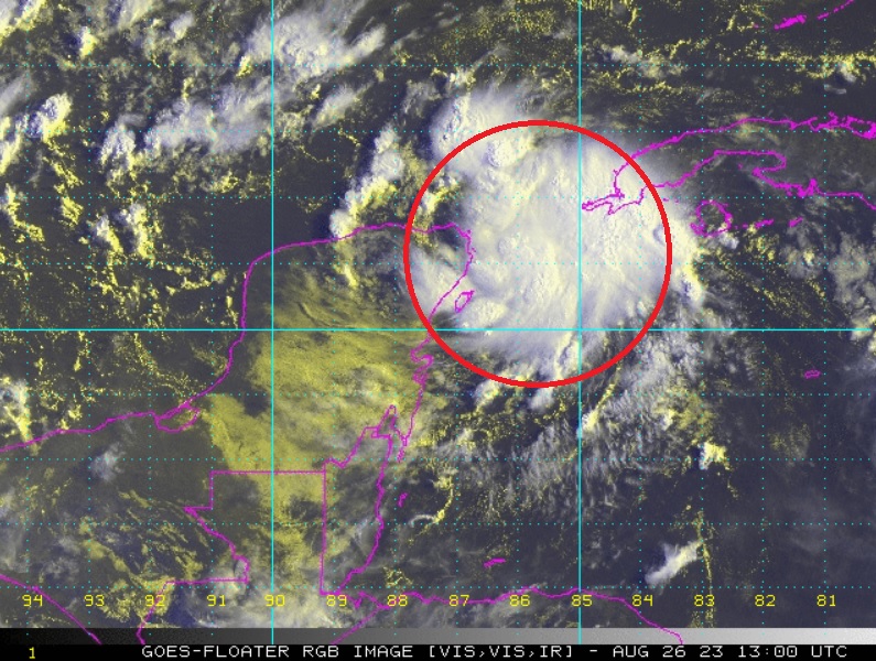
First light helps confirm overnight ship and buoy reports that a small well-defined low-level vortext most likely exists under increasingly better-organized deep convection, and a tropical cyclone may already exist or presently be forming, somewhere about 21N 86W as of 26/1300z in the image above.
Smaller T.C.s can be especially challenging for models to identify and forecast, and at this point I would take any models that call for a weaker tropical cyclone in the Gulf with a grain of salt. With the especially favorable SSTs, things could ramp up quite a bit more.
Unfortunately for all, scatterometer has missed 93L for almost 24 hours, and recon won't be out until tomorrow.
There is possibly already a small core of winds to tropical storm force in the system.
| cieldumort |
| (Moderator) |
| Sat Aug 26 2023 06:32 PM |
|
|
|
|
#93L (Idalia-to-be if you will) is drifting about over deeply very warm waters in a steering current collapse left in Franklin's wake, and it may not be until about late Monday or Tuesday before a High in between the two becomes established enough to get 93L moving towards the coast in a meaningful way.
Idalia-to-be has an unpleasantly large window to intensify over exceptionally warm SSTs and in an environment of lower to low shear. The potential for this cyclone to Major is arguably well above average.
Here is my initial best guess lifetime Maximum Sustained Winds for Invest 93L (Future Idalia)
<35 KTS 1%
35-45 KTS 4%
50 KTS - 60 KTS 10%
Cat 1 15%
Cat 2 18%
Cat 3 22%
Cat 4 22%
Cat 5 8%
A little less confidence as usual for when I attempt to roll these out, entirely because as of now we have had no recon, and very sparse scatterometer data.
Looked at another way, I assign an 85% chance that 93L becomes a hurricane at some point - and a better than 50% chance that 93L Majors.
Interests from northern Yucatan to western Cuba to South Florida to Alabama could be at risk, as the future steering pattern is far from well understood. Having recon is ASAP will be a great benefit.
| OrlandoDan |
| (Weather Master) |
| Sat Aug 26 2023 07:58 PM |
|
|
|
|
Very good agreement between GFS and Euro. The smallest difference will make a huge difference in the landfall given the relative positions of the panhandle and the storm. All interests on the Gulf Coast of Florida should be cautious. Obviously the Panhandle and Big Bend areas should be especially diligent.
| vineyardsaker |
| (Weather Guru) |
| Sat Aug 26 2023 10:52 PM |
|
|
|
|
Post deleted by vineyardsaker
|
MikeC
|
| (Admin) |
| Sat Aug 26 2023 11:40 PM |
|
|
18z GFS landfall near St. Marks Midday Wednesday Cat 2
18z Icon Landfall Wednesday morning near Tampa, Tropical Storm
12z Euro Cat 1 Landfall Near Steinhatchee Wednesday Afternoon
18z HAFSA- Landfall Near Crystal River cat 3 Hurricane Early Wednesday Morning (Rakes surge along Tampa North to Crystal River)
18z HAFSB - Landfall Near Cedar Key, Cat 2/3 Hurricane Wednesday morning
18z HMON Lnadfall Near Mexico Beach Cat 3 Hurricane Wednesday morning
|
MikeC
|
| (Admin) |
| Sun Aug 27 2023 05:20 PM |
|
|
Not enough time for models, but with recon reports today there's a decent chance the track will shift further right (East/south) at 5pm. The 12z models did not have any recon data in them.
| OrlandoDan |
| (Weather Master) |
| Sun Aug 27 2023 05:28 PM |
|
|
|
|
Mike, just curious why you are forecasting a shift right?
|
MikeC
|
| (Admin) |
| Sun Aug 27 2023 05:42 PM |
|
|
Mainly comparing inital positions of the 12z models to the recon vortex messages. Recon was ese about 50-60 miles. So I'd expect a slight shift right at 18z. Likely still north of tampa toward the big bend, though. Still I wouldn't gamble with not doing preparations along the west coast. Impacts could be larger than the cone to the right of landfall.
| cieldumort |
| (Moderator) |
| Sun Aug 27 2023 06:11 PM |
|
|
|
|
There looks to be a few reasons why rightward adjustments to the forecast track may be coming.
In general, there has been more of a blowup of convection downshear from the center and this is likely to continue off and on. What has occurred most recently isn't as much as a center jump per se, than more likely a cyclonic loop responding to the changing steering currents. But going forward, given the lopsided convection at present and forecasts of some on again off again modest northwesterly shear, one could expect a better chance of either center reformations or just simply adjustments downshear (to the east). All that said, a better chance is not saying such an outcome is certain. In addition, that northerly/northwesterly shear may be less than expected.
At this point, I'm all but ignoring 12z model runs myself (at least as far as Idalia is concerned). I want to see both the 18z and 0z runs before biting on anything.
| cieldumort |
| (Moderator) |
| Sun Aug 27 2023 07:24 PM |
|
|
|
|
After ingesting this morning's recon data, 18z runs are trending more towards a landfall in the Big Bend area, not less. This should yet be taken with caution. Idalia is still in early development stages, and models often do not handle the tugs and jumps associated with lopsided convection as well as one would like.
| OrlandoDan |
| (Weather Master) |
| Sun Aug 27 2023 07:46 PM |
|
|
|
|
Appreciate the reply, Mike.
I expect some diffluent upper-level flow to the east of
the trough and this will likely be conducive for strengthening.
| cieldumort |
| (Moderator) |
| Sun Aug 27 2023 10:01 PM |
|
|
|
|

As the sun begins going down over Franklin, from a wide view, it becomes easy to appreciate how much larger Idalia is becoming.
The tropical cyclone inner vortex was always small, but wrapped up a bit inside a larger monsoonal depression that crossed over Central America. It now appears that the southward realignment as the result of northwesterly shear working with what was probably otherwise a routine attempt at a loop, has re-coupled the T.C's tight vortex more with its parent monsoonal low. This could have significant implications for the size of Idalia's wind field, amount and duration of heavy precipitation (with attendant flooding), as well as its future track.
It will be informative to see if 0z runs initiate or quickly catch up to the more bloated cyclone.
| MichaelA |
| (Weather Analyst) |
| Sun Aug 27 2023 10:38 PM |

|
|
|
My wife and I left Pinellas Park on Thursday morning on our annual trek to northern NY through September. My daughter remains home and has completed her storm preparations. I’ll be monitoring things from afar and watching data from my PWS. Hopefully, Tampa Bay will luck out again.
| Prospero |
| (Storm Tracker) |
| Mon Aug 28 2023 12:02 AM |
|
|
|
|
Quote:
My wife and I left Pinellas Park on Thursday morning on our annual trek to northern NY through September. My daughter remains home and has completed her storm preparations. I’ll be monitoring things from afar and watching data from my PWS. Hopefully, Tampa Bay will luck out again.
We restocked our batteries and will replace the old ones in our flashlights. We'll make sure our CPap battery backups are charged.
Duke Energy has replaced most of the power poles in our area (Gulfport, FL) so hopefully we are not the first to lose power during the storm like usual. In the past as soon as we get a stiff breeze the power would go out. UGH
| cieldumort |
| (Moderator) |
| Mon Aug 28 2023 12:44 AM |
|
|
|
|
Some visual aids as to how Idalia might look during the middle of the night Tuesday (06z or 07z on the 30th), based on 8/27/18z runs of these respective models
Simulated IR model runs:
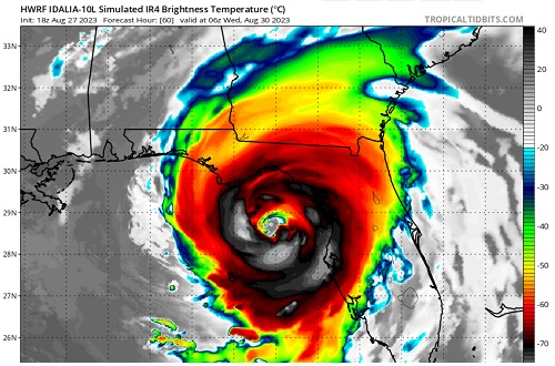
HWRF
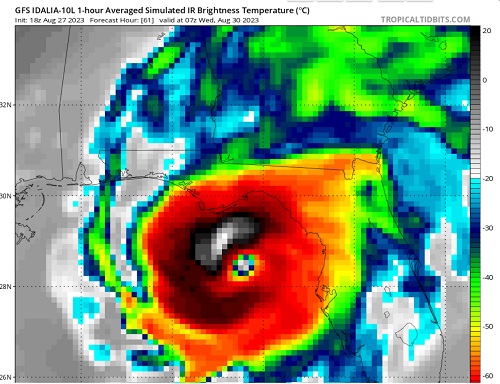
GFS
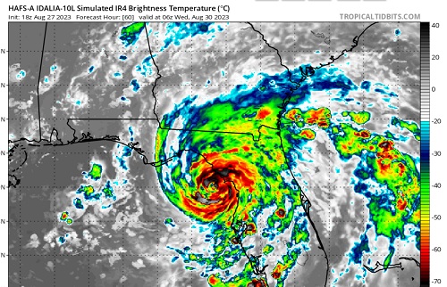
HAFS-A
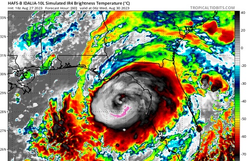
HAFS-B
| cieldumort |
| (Moderator) |
| Mon Aug 28 2023 03:41 AM |
|
|
|
|
Here are my updated best guesses as to Idalia's peak lifetime maximum wind speed. I should add that this is also most likely to occur prior to crossing Florida, and possibly right into landfall.
<35 KTS 0% (Has exceeded)
35-45 KTS 0% (Has exceeded)
50 KTS - 60 KTS 2% (Current wind speeds estimated by NHC)
Cat 1 4%
Cat 2 17%
Cat 3 24%
Cat 4 31%
Cat 5 22%
Or looked at another way, I now give a 94% chance that Idalia becomes a hurricane, a 77% chance that Idalia becomes a Major, a 53% chance that Idalia becomes a high-end Major, and a 22% chance that Idalia becomes a Category 5.
There are still several things that could go wrong for Idalia and prevent it from becoming a Major hurricane, but there are also more things that seem to be setting up "right" (for higher-end hurricane).
| cieldumort |
| (Moderator) |
| Mon Aug 28 2023 07:26 AM |
|
|
|
|
28/0z model runs ingested quite a bit of Hurricane Hunter data and as such are of greater interest
Vortex-scale hurricane models
0z HWRF - Initialized a touch too far northwest, but not horribly. Majors overnight Tuesday, becoming Cat 4 heading into landfall (in fact, 850hPa wind suggests a potential for gusts exceeding 150 KTS predawn Wednesday). Landfall as a Cat 3+ in vicinity of Redfish Point, Apalachee Bay Wednesday morning.
0z HMON - Also initialized a touch too far northeast, but not horribly. Majors Tuesday morning. High-end Cat 2 heading towards landfall overnight Tuesday. Landfalls in vicinity between Steinhatchee and Fish Creek early Wednesday morning probably about Cat 2.
0z HAFS-A Solid inititial location. Majors heading into landfall predawn Wednesday, with an apparent landfall location somewhere between Horseshoe Beach and Steinhatchee as a Major early Wednesday morning.
0z HAFS-B Solid initial location. Majors Tuesday evening. Cat 4s Tuesday overnight. Landfalls roughly southeast of St Marks in the Apalachee Bay Wednesday morning, seemingly Cat 2/3.
| bob3d |
| (Weather Watcher) |
| Mon Aug 28 2023 10:24 AM |
|
|
|
|
With the vast majority of the models showing a Big Bend landfall with each update, and the cone of uncertainty is getting more and more precise, I noticed it is always showing Tampa Bay in its right-most sector of the cone. Since I live just north of Tampa, this is getting more and more concerning to me as the forecast storm strength increases with each model run.
| IsoFlame |
| (Weather Analyst) |
| Mon Aug 28 2023 05:52 PM |

|
|
|
When Idalia has increasing structure/organization (as forecast) over the exceptionally warm eastern GOMEX Tuesday/early Wednesday in a very favorable environment for rapid intensification, Cat 4 may be within reach especially if the forward speed stays around 10 mph and the inner core stands off the Fla west coast until landfall north of St.Pete/Clearwater (given Franklin's impressive 11am stats on the other side of the peninsula: 145 mph / 937mb)
| IsoFlame |
| (Weather Analyst) |
| Mon Aug 28 2023 06:22 PM |
|
|
|
|
Recon coming in today ahead of Idalia's intensification will refine the forecast.

What will be very problematic for predicting the greatest impact Idalia will have on Florida's west coast will be the propensity for TC's tracking north in the eastern GOMEX (parallel to the Fla peninsula) to "right turn Clyde" on the south side of modeling.
| Prospero |
| (Storm Tracker) |
| Mon Aug 28 2023 06:30 PM |
|
|
|
|
Quote:
...
What will be very problematic for predicting the greatest impact Idalia will have on Florida's west coast will be the propensity for TC's tracking north in the eastern GOMEX (parallel to the Fla peninsula) to "right turn Clyde" on the south side of modeling.
Our home in Gulfport FL was in the center of the cone on the mornings of Irma and Ian if I remember correctly. Both storms left the cones and shifted East. I think right now I'd feel much more relaxed if Tampa Bay was in the center of the cone. But if I lived in Sarasota I'd be nervous.
| IsoFlame |
| (Weather Analyst) |
| Mon Aug 28 2023 07:11 PM |
|
|
|
|
Very Impressive : Idalia deep convection
Rapid intensification soon to follow.
| cieldumort |
| (Moderator) |
| Mon Aug 28 2023 10:50 PM |
|
|
|
|
Idalia conditions in your area
| Rick31416 |
| (Registered User) |
| Tue Aug 29 2023 04:13 AM |
|
|
Sure seems to me it's lost it's shear, fanning out in that direction, and formed something of an eye. And it's racing north.
Not that I have a clue, other than being in a dozen hurricanes, and watching the pretty pictures.
https://www.tropicaltidbits.com/sat/satlooper.php?region=10L&product=ir
| cieldumort |
| (Moderator) |
| Tue Aug 29 2023 07:17 AM |
|
|
|
|
The 29/0z GFS ensembles are out and if you like heartburn or were a fan of Ivan....
| OrlandoDan |
| (Weather Master) |
| Tue Aug 29 2023 12:51 PM |
|
|
|
|
Saw on WESH 2 news in Orlando that she may have taken a slight jog right. What impacts this have if it continues?
| JMII |
| (Weather Master) |
| Tue Aug 29 2023 02:08 PM |

|
|
|
Quote:
The 29/0z GFS ensembles are out and if you like heartburn or were a fan of Ivan....
A loop back is super rare... but given the right conditions anything is possible.
Idalia is behaving as predicted: starting to wrap up, entering a low shear/high heat environment, all signs that a Cat 3/major status should occur. In the water vapor satellite loops you can see the weather pattern over LA/TX that will curve her east.
| IsoFlame |
| (Weather Analyst) |
| Tue Aug 29 2023 02:54 PM |
|
|
|
|
Until we have a visible eye, follow Idalia's progress on radar
| cieldumort |
| (Moderator) |
| Tue Aug 29 2023 02:55 PM |
|
|
|
|
Quote:
Saw on WESH 2 news in Orlando that she may have taken a slight jog right. What impacts this have if it continues?
I noticed something like that from back when Idalia was tracking just west of Cuba, but the "jog right," if that is indeed what it was, isn't a big one, and in fact, the most recent recon pass through the cyclone just had a slight hook left.
Track has been more or less due north overall. I suspect that looking at its movement as smoothed over three to six hours, as NHC does, is still going to be most informative in the longer-term. Temporary wobbles and jogs as Idalia is approaching the coast would have some greater immediate significance to those in her path of course.
| IsoFlame |
| (Weather Analyst) |
| Tue Aug 29 2023 03:03 PM |
|
|
|
|
My son lives in St. Pete (on high ground) and my 90-yr old dad lives in Brunswick, GA. After Idalia landfalls in/near the Big Bend, I expect that my dad will have higher winds (with minimal surge) if Idalia "right hooks" and tracks through SE GA as a Cat 1 or strong TS.
| JMII |
| (Weather Master) |
| Tue Aug 29 2023 05:53 PM |
|
|
|
|
Quote:
Track has been more or less due north overall. I suspect that looking at its movement as smoothed over three to six hours, as NHC does, is still going to be most informative in the longer-term. Temporary wobbles and jogs as Idalia is approaching the coast would have some greater immediate significance to those in her path of course.
This +1
I use the map at https://www.wunderground.com/wundermap with the hurricane and radar layer active. She was E of track this AM but has wobbled back W. As mentioned wobbles this far out don't mean much unless a clear trend emerges. Based on past storms the NHC can be slow in making long term adjustments as to not over-react. Irma was a good example of this, she kept missing her forecast positions thus the final landfall (5 days later) switched from the E coast to the W coast of FL (100 mile error). Technically she stayed inside the 3 day cone but everyone gets hyper focused on that center line then acts surprised when landfall is somewhere else.
| Psyber |
| (Storm Tracker) |
| Tue Aug 29 2023 07:33 PM |

|
|
|
There's a ridge on the 588 that has been developing and moving west to the where is is now right over just over the pan handle. The storm is most likely going to turn according to this ridge. This is what is causing the storm to bounce n n/w. Once the storm gets past this southerly pushing ridge, the storm will make its turn. This is one of the reasons why the storm is so close to shore yet landfall projections are up to 100 miles apart of probability where it's going to land.
Lastly, it CANNOT be ignored or stated strongly enough about how much of a flooding event this probably will be.
I know other people have said it but it should be said again because this really is that dangerous. People should consider driving inland, west of the storm to get out of potential 12 feet plus flooding. Possibly once in a lifetime flooding for those areas on the inside of the pan handle.
| HurricaneSteph |
| (Verified CFHC User) |
| Tue Aug 29 2023 07:55 PM |

|
|
|
Is it just me or is the latest satellite showing a visible wobble or shift to the east?
| vineyardsaker |
| (Weather Guru) |
| Tue Aug 29 2023 08:00 PM |
|
|
|
|
As somebody who lost his home from Ian last year, I totally concur. Do *NOT* get stuck in your house, if it floods it will flood VERY QUICKLY and it is even worse in pitch darkness. If you are anywhere along the West coast of FL, evacuate , even for just 24 hours, get to any friends/hotel inland and on higher ground. And, before you leave, try to lift to higher places your most precious belongings (well, the most precious take with yourself): on beds, on closets, 2nd floors, safe rooms, etc. etc. etc. 30 mins of house preparations could make a huge difference to what you might lose.
Good luck to all and God bless!
| cieldumort |
| (Moderator) |
| Tue Aug 29 2023 08:14 PM |
|
|
|
|
Quote:
Is it just me or is the latest satellite showing a visible wobble or shift to the east?
I've also noticed a very slight lean to the right recently based on radar, Flhurricane Facebook Post , but big-picture, it might not be outside of the forecast plots. Fortunately, recon is almost back in so we should know a lot more this evening.
| Rick31416 |
| (Registered User) |
| Tue Aug 29 2023 08:25 PM |
|
|
It's drifting slightly east, but that was predicted. It's dead centered on the predicted track.
https://www.wunderground.com/wundermap
| IsoFlame |
| (Weather Analyst) |
| Tue Aug 29 2023 11:30 PM |
|
|
|
|
A lot of intense lightning in outer band of convection well north and east of Idalia, and the moisture tail extending well south into the western Caribbean Sea:

| JMII |
| (Weather Master) |
| Wed Aug 30 2023 12:39 PM |
|
|
|
|
Starting falling apart at landfall, the whole SE quad is missing. NE eyewall hit Perry where several YouTubers were. Radar based estimates put the winds at 70 to 110 MPH, so Cat 2 maybe. The track verified really well but winds are over-estimated which is typical for the NHC as they tend to err on the side of being too high vs too low.
| Kraig |
| (Weather Hobbyist) |
| Wed Aug 30 2023 04:12 PM |

|
|
|
It was a very fortunately timed eyewall replacement cycle that started just after 5am that took much of the momentum and energy away just prior to landfall.
| IsoFlame |
| (Weather Analyst) |
| Wed Aug 30 2023 06:47 PM |
|
|
|
|
Quote:
It was a very fortunately timed eyewall replacement cycle that started just after 5am that took much of the momentum and energy away just prior to landfall.
That and heading toward low tide at the time of landfall. Still, historical flooding (ongoing) in Steinhatchee Family friend has a generational "cabin" used as a base camp for scallop season that has seen water in it numerous times from lesser storms over the years- but never washed away. I'm not sure if it was able to withstand Idalia's surge.
| Sam568 |
| (Registered User) |
| Thu Aug 31 2023 01:17 AM |

|
|
|
Been a lurker for years; just now registered. Thank you for this forum. Has anyone looked at the Keaton Beach buoy data set from this morning?
https://www.ndbc.noaa.gov/station_page.php?station=ktnf1
Wind speed data from 0800 is missing (reported as 0). NHC reports landfall at 0745, so 0800 windspeed from that buoy would be factual measured information. Pressure/Temp data at 0800 is reported, so unlikely to be a satellite send failure. Anemometer apparently did not blow away, as wind speed data resumed at 0900 and still reporting. Any thoughts or insights regarding this anomaly? Datalogger info would likely still be there and be physically available. Asking for a friend who examines factual data and is curious about how much wind speed suddenly drops in an "eyewall replacement cycle".
| JMII |
| (Weather Master) |
| Thu Aug 31 2023 03:14 PM |
|
|
|
|
Zero wind speed could be the eye overhead. I didn't check myself, but if the pressure is the lowest during this measurement that would tell me the calm eye crossed this station at that time stamp.