| IsoFlame |
| (Weather Analyst) |
| Fri Sep 01 2023 12:48 PM |

|
|
|
While it's way too early to give much credence so far in advance...
Last several runs of the GFS show a Cape Verde origin TC tracking W/WNW at a fairly low latitude across the central Atlantic while becoming a hurricane, strengthening to Major and skirting just north of the Lesser Antilles, tracking WNW/NW through or just east of the Bahamas, maintaining strength on a general approach to be very near Florida's east coast around Sept 12-14th:
GFS 12Z Wed. Sept 13 2023
This model advertised system is now 95L and the title has been updated accordingly.[
Now THIRTEEN 9/5/11AM ET; Lee 5PM - Ciel
| cieldumort |
| (Moderator) |
| Mon Sep 04 2023 06:38 PM |

|
|
|
This well-forecast system (Invest 95L officially now) has many days for us to keep an eye on and sure counts as a lower (but not very low) probability - higher (and maybe very high) impact risk.
Most models favor vigorous intensification in the Tropical Atlantic while 95L is still well east of the Antilles. Such would favor a more poleward, and hopefully fish-ward, recurveature. However, there's a fair chance 95L stays on the relatively weaker side, which would tend to favor a more southerly track earlier on and that could put islands and eventually the CONUS at greater risk of impact. There are even a few solutions that hint of a robust, expansive Bermuda High regardless of 95L's intensity a week from now.
I think that being the time frame for potential US land impacts is still in the 7-14 days out range, it really questions the limits the models' abilities to be anything more than noise. But, by the end of the coming week we should be able to put a lot more stock in them, especially once recon starts going in.
| IsoFlame |
| (Weather Analyst) |
| Mon Sep 04 2023 08:41 PM |
|
|
|
|
Quote:
However, there's a fair chance 95L stays on the relatively weaker side, which would tend to favor a more southerly track earlier on and that could put islands and eventually the CONUS at greater risk of impact. There are even a few solutions that hint of a robust, expansive Bermuda High regardless of 95L's intensity a week from now.
I think that being the time frame for potential US land impacts is still in the 7-14 days out range, it really questions the limits the models' abilities to be anything more than noise. But, by the end of the coming week we should be able to put a lot more stock in them, especially once recon starts going in.
I thought most models handled Idalia's track and intensity amazingly well a week in advance before the system organized and recon was available. Once extensive recon data started flowing in this added to the confidence and facilitated warnings well in advance along Florida's Gulf coast, saving many lives given the record storm surge in the Big Bend and areas north of St.Pete.
A weaker system in the central Atlantic on a W/WNW track into the islands, re-emerging/intensifying over the western Atlantic in very favorable atmospheric and oceanic conditions as the Bermuda high strengthens to 1030+ mb (strongest of the season) north of the TC while ridging westward could be a Andrew-like scenario for somewhere along the southeast US coast.
I'm hoping for a weakness in the ridge to allow re-curvature 300 (or more) miles offshore- no impact to Florida (other than good surf). I also hope another high doesn't set up over the northeast and friends on the Outer Banks also enjoy good surf while avoiding direct impacts.
| cieldumort |
| (Moderator) |
| Mon Sep 04 2023 10:01 PM |
|
|
|
|
Quote:
I thought most models handled Idalia's track and intensity amazingly well a week in advance before the system organized and recon was available
Depends on the model \_(ツ)_/¯
One week prior to Idalia's landfall was a mixed bag as to whether or not there would even be an Invest-able disturbance in the Caribbean/Gulf region on Wednesday August 30, let alone landfall location of a hurricane. ECMWF did exceptionally well, but others increasingly did not. Idalia wasn't even on the GFS radar then, and an Invest tagged system had even yet to be assigned to the dynamic track and intensity models HWRF, HMON and HAFS.
Model ability to accurately predict the synoptic scale steering flow especially after 10 days but even within the 7-10 day window is pretty limited. No doubt that 95L will be named and most likely become a Major, but GFS calling for a major very near the Florida east coast two weeks out is a possible outcome, but of dubious reliability.
95L has some scary dangerous potential if it heads to land. Certainly one to watch closely.
| cieldumort |
| (Moderator) |
| Tue Sep 05 2023 02:39 PM |
|
|
|
|
NHC will initiate advisories this hour on THIRTEEN. The opening intensity forecast from NHC is going to pop people's eyeballs out.
| Robert |
| (Weather Analyst) |
| Tue Sep 05 2023 06:15 PM |

|
|
|
The only outlier is the Navy Nogaps model on the weaker side, also with more robust Blocking, due west at 20n and land interaction, Hati and cuba to help knock it down a little.
Yesterday, 18z into Cuba, 0z into Cuba, 06z stall out in the Bahamas then moving north, 12z this morning cuba then Gulf of mexico..
The Nogaps was also the outlier with Idalia showing a weaker system and further east, and it was wrong that time.
Going to have to go with the main Models stronger and out to sea for now..Although I can see where a stronger ridge, faliure to ramp up, and land interaction can cause a more Gulfward scenario, alot of the systems that have come out of the MDR have lagged behind the main models in thier timeline to ultimate strength, so why would this be different, could also be the nhc holding back on the actual strength and structure of some of the systems they seem to be self verifying thier own forcast these days, especcialy non concern systems...Will be interesting to watch over the next 72 hours, could hold those awnsers.
| IsoFlame |
| (Weather Analyst) |
| Tue Sep 05 2023 06:25 PM |
|
|
|
|
Model ability to accurately predict the synoptic scale steering flow especially after 10 days but even within the 7-10 day window is pretty limited. No doubt that 95L will be named and most likely become a Major, but GFS calling for a major very near the Florida east coast two weeks out is a possible outcome, but of dubious reliability.
95L has some scary dangerous potential if it heads to land. Certainly one to watch closely.
Definitely. The different models have differing ability to discern change over time, and each TC present unique challenges, 5-7 days out is where I look consensus. 3-5 days I look for model to fine-tune the cone of impact.
I did not have great trust in models for Andrew, Floyd and Dorian- the 3 majors tracking toward Florida that were of great concern until passage. ATM, this one has my undivided attention, even though latest modeling suggest re-curvature well to the east. If timing allows a strong high pressure ridge to set up north of the TC as it re-curves WNW/NW to the east of the Bahamas, a stair-step westward toward the Florida peninsula, or elsewhere along the east coast, could be a possibility.
| cieldumort |
| (Moderator) |
| Tue Sep 05 2023 09:16 PM |
|
|
|
|
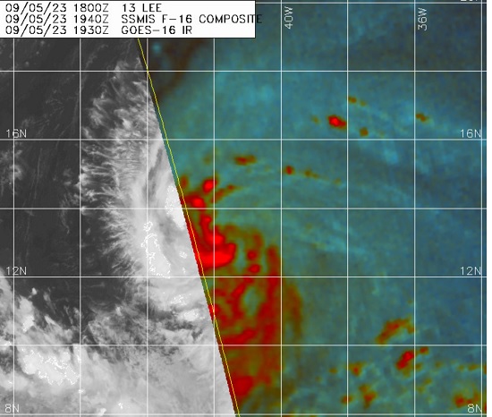
Lee's structure is incredibly solid for a newly named tropical storm, and there are reasons to suspect that maximum sustained winds may already be higher than the 5PM NHC advisory.
This morning, Lee (then TD 13) was analyzed to be located near 12.5N 40.2W, with the forecast position 12 hours from then at 12.8N 42.1W, or far more west than north.
As of the 5PM Advisory, Lee is now analyzed to be located at 13.2N 41.8W, the center having tracked 0.7N and 1.6W over the course of six hours, compared to the 0.3N 1.9W anticipated over twelve hours. This is a bit faster and more poleward than NHC first forecast, or reflects a center readjustment/hop.
While it is possible that Lee adjusts southerly back to the Adv 1 forecast, that is unlikely. Nonetheless, as per the 5PM NHC Discussion, " a mid-level ridge over the central Atlantic likely to persist to the north of the storm. This ridge should provide a steady steering current, with a general west-northwestward course expected through the weekend with some reduction in forward speed."
| cieldumort |
| (Moderator) |
| Wed Sep 06 2023 01:02 AM |
|
|
|
|
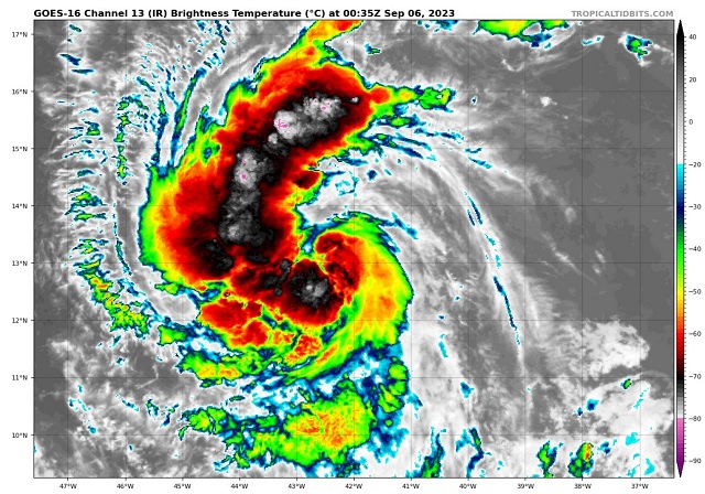
Ultimately, those of us on land are more concerned about track than intensity, assuming Lee's intensity is going to be a problem no matter what (at this point it's fair to assign close to 100% odds of Lee becoming a hurricane within 5 days, for example).
But Rapid Intensification sooner rather than later, and just the timing of Lee's rounds of R.I. in general, could influence Lee's destinations, and Lee appears to be preparing to enter a phase of quick if not technically rapid intensification as soon as overnight tonight. This is not to say that Lee goes from 40 KTS to 70 KTS by morning, but that this is plausible, and not presently captured by the models nor in the official NHC forecast.
As members and lurkers of this site know, typically the stronger the T.C., the greater the propensity for it to feel the tugs poleward. But a turn north is not always the outcome, as influences from a much stronger-than-forecast Lee could ultimately help buff up the ridge to his north. These types of things are still challenging for models and forecasters to predict. In fact, in the case of Lee, intensity five days out may be about as easy to forecast as location (Usually intensity being far more challenging).
What seems all but certain and is predicted by most reliable models is that Lee becomes a Major hurricane within 5 days as he tracks roughly WNW. Possibly a little left or right of that, but unlikely to be much outside of the NHC 5 Day Cone of Uncertainty, if at all.
Warm-water prawn of the sea, Lee
| cieldumort |
| (Moderator) |
| Wed Sep 06 2023 01:35 AM |
|
|
|
|
For funzies, here is my initial lifetime maximum sustained wind intensity best guess for Lee.
40 KTS (current advisory) 0%
45-50 KTS 0%
60 KTS 0%
65 KTS 2%
70-80 KTS 3%
85-95 KTS 3%
100-110 KTS 8%
115-125 KTS 12%
130-135 KTS 22%
140-150 KTS 28%
155-170 KTS 17%
>170 KTS 5%
Or looked at another way, I give a statistical -0- percent chance that Lee does not become a hurricane of any category, a 92% chance that Lee Majors, and for the Six Million Dollar question, how high up the scale does this go: 72% odds that Lee becomes a Cat 4 or 5, and a 50% chance that Lee becomes a Cat 5.
MikeC
|
| (Admin) |
| Wed Sep 06 2023 10:38 AM |
|
|
Models overnight keep Lee away from land areas, close enough for very rough surf, but no direct impacts in the Caribbean islands. Bermuda, Canadian Maratimes, Outer Banks, and the Northeast US may have to watch out in the longer run based on the trends, but most likely it'll will stay east of land. That track east would still bring rip currents and very rough surf to much of the east coast.
Lee is worth monitoring for changes because of how strong it may become, however, but right now things are looking pretty good for minimal direct impacts to land.
Most models overnight shifted to the right, east, including the UKMet. 0z Euro keeps it interesting with a potential threat to the Northeast as a ridge starts to build in north of the storm toward the end of the run. Maine/Canada may get the remnants of Lee on the GFS (6z landfall near Maces Bay in New Brunswick after clipping the western edge of Nova Scotia). Bermuda needs to watch too based on CMC/UKMet (Canadian puts Bermuda in the dirty side of Lee at Cat 3). Too soon to tell really beyond 5 days. The turning point north, which is just beyond the NHC's forecast (roughly 7 days from now) will be likely one of the more interesting points to watch as the situation north of there at the time may indicate how far east or west Lee ultimately goes.
| JMII |
| (Weather Master) |
| Wed Sep 06 2023 03:02 PM |

|
|
|
These long range 'canes are always worth keeping an eye since weather patterns 5 to 7 days out have way more variables then a 2 to 3 forecast window. Lee looks really impressive already with well established outflow channels and solid core starting to form. Glad to see the models keeping this away from land given what should be an easy path to a high intensity major storm.
|
MikeC
|
| (Admin) |
| Thu Sep 07 2023 12:02 PM |
|
|
Models overnight tongiht are fairly well Algned with the Canadian closest to Bermuda. Direct impacts on the US east coast are more unlikely as a result, but not ruled out. Euro is not slow like it was, but a lot hinges on the turn to the north, which should be well away from the Bahamas and Florida to the east. Even the ensembles are keeping it away from land.
Worth monitoring for changes, but unless something change than Bermuda and the Canadian Maritimes should keep monitoring. The east coast will be watching the turn and beyond. But until that happens not much will likely change with the forecast. Currently anything in the MDR is most likely to recurve. 96L may have to be watched by the azores.
Recon arrives in Lee today, so that should give the models tomorrow a better idea for the next 5-7 days or so.
| flanewscameraman |
| (Weather Watcher) |
| Thu Sep 07 2023 10:03 PM |
|
|
A question, 5pm update says there is uncertainty in any turn north at 5 days. Wanted to get your thoughts on what that means if anything.
“There is uncertainty in any northward turn of Lee beginning early
next week, but it is too soon to speculate about specific potential
impacts a week or more out.â€
| cieldumort |
| (Moderator) |
| Thu Sep 07 2023 11:32 PM |
|
|
|
|
With respect to the timing of Lee's well advertised turn, there is timing uncertainty, but not so much so that Florida is (and was never) part of the NHC cone. Timing uncertainty currently exists more to as how much Lee may or may not impact the northeast and Canada. That said, Major Hurricanes have been known to occasionally strongly influence their own steering currents.
Recon is now flying into Lee. The recon data supplied this week will be invaluable.
| IsoFlame |
| (Weather Analyst) |
| Fri Sep 08 2023 01:57 AM |
|
|
|
|
Quote:
With respect to the timing of Lee's well advertised turn, there is timing uncertainty, but not so much so that Florida is (and was never) part of the NHC cone. Timing uncertainty currently exists more to as how much Lee may or may not impact the northeast and Canada. That said, Major Hurricanes have been known to occasionally strongly influence their own steering currents.
Recon is now flying into Lee. The recon data supplied this week will be invaluable.
Models keep Lee a Major up to the New England coast. Timing of the much advertised northerly will end up being critical for mitigating impact (other than dangerous seas and high surf) to the northeast US, and especially the Canadian Maritime provinces which have taken a beating during hurricane season in the past half decade.
| Rick31416 |
| (Registered User) |
| Fri Sep 08 2023 03:13 AM |
|
|
Is it just me, or do they always seem to underestimate the strength lately? Could be going for the record here.
One thing's for sure, it's an excuse to double my insurance again like they did last year.
| JMII |
| (Weather Master) |
| Fri Sep 08 2023 03:28 AM |
|
|
|
|
The 11PM discussion mentions winds could reach 178 MPH given the current rate of intensification and environment (low shear, high ocean temps, cold cloud tops). The system is compact and tightly wrapped around a solid core. Impressive… and thankfully no where near land.
|
MikeC
|
| (Admin) |
| Sat Sep 09 2023 10:46 AM |
|
|
Lee is still fighting shear this morning, but the shear starting to change direction causing a bit of a intensification run (not as extreme as Thursday, though) Recon not cutting through the center overnight because of mesovortices highlights that part oft.
Models are still pretty consistent with a right/north turn around Wednesday, and the remainder is effectively based on where the turn hits. Bermuda will see affects, but likely not the worst of it directly. The US East coast will see the large waves, but the most likely direct impact area is Atlantic Canada right now, if any. And Lee should be much weaker then. Still predicated around the turn though, so continues to be watched.
Euro misses Canada this time, but is still having issues with Margot, and completely misses trough interaction. GFS is into Atlantic Canada, so those are the two most likely scenarios at the moment. Either completely avoiding land, or Atlantic Canada. West of there should monitor, but that's, so far, what seems to be heading toward.
|
MikeC
|
| (Admin) |
| Sat Sep 09 2023 07:28 PM |
|
|
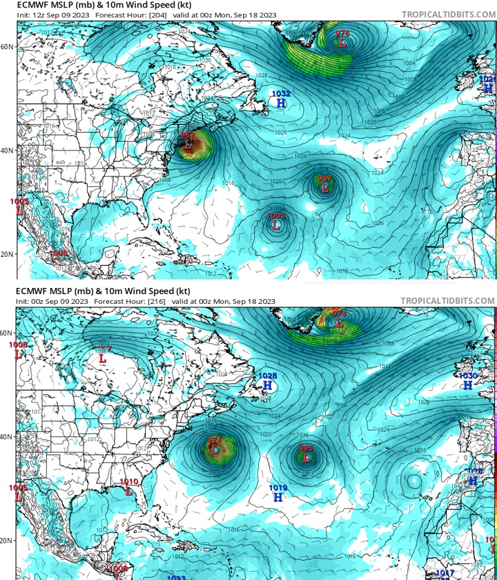
12z Euro is a big change, Cat 3 into Rhode Island in the evening of Sunday Sep 17 (After regaining Cat 5 near the turn). 1z Gfs is into Nova Scotia.
What I think it means. Margot is still an influence, and we can't exclude New England. The turn north is still 4 days out.
| cieldumort |
| (Moderator) |
| Sat Sep 09 2023 08:29 PM |
|
|
|
|
Perhaps the most notable change of potential steering influences in the 12z vs 0z runs is EURO's now forecast Tropical Storm Nigel replacing what was a 1019mb High. Also noteworthy is the stronger ridge to Lee's north (1032 vs 1028). A lot of Lee's future track may hinge on one or both of these outcomes, and it seems that Lee, Margot and Forecast-Nigel have a bit of a dance to do in order for this to all play out as the 12z foresees.
|
MikeC
|
| (Admin) |
| Sun Sep 10 2023 06:11 PM |
|
|
!2z is generally a left shift in all the Models, operationals (Except for Icon which landfalls on Cape Cod) is still Nova Scotia, but further left than prior. The GFS ensemble mean point is now Maine, however.
Latest recon suggestions Lee is back to Major Hurricane strength now, probably officially at 5pm.
12z Euro has shifted west into Western Nova Scotia (not as much as the west shift to Rhode Island yesterday, but still all major models have shifted left today)
|
MikeC
|
| (Admin) |
| Tue Sep 12 2023 11:41 AM |
|
|
0z Euro showing a bend back west toward cape cod before a Maine landfall, while others are showing Nova Scotia
|
MikeC
|
| (Admin) |
| Wed Sep 13 2023 02:54 AM |
|
|
Most models have focused toward maine or the western edge of Nova Scotia/ or right up the Bay of Fundy.
However the 18z euro ensembles have had a pretty significant shitt west, toward Central Maine. and get much closer to Cape Cod which is concerning (not going the right direction). A more pronounced bend back west north of North Carolina. Something to watch, but may be enough for the official track to shift a bit west at 5am if overnight models keeps that up.
|
MikeC
|
| (Admin) |
| Wed Sep 13 2023 04:16 AM |
|
|
0z gfs shifted left, expect a NHC track shift west at 5AM
| JMII |
| (Weather Master) |
| Fri Sep 15 2023 12:10 PM |
|
|
|
|
Quote:
Most models have focused toward maine or the western edge of Nova Scotia/ or right up the Bay of Fundy.
Given the Bay of Fundy has the largest tide on earth what is the surge going to be like there?
| cieldumort |
| (Moderator) |
| Fri Sep 15 2023 06:21 PM |
|
|
|
|
Environment Canada:
Quote:
c. Surge/Waves.
High waves and elevated water levels will be widespread due to the large size of the storm - the most impacted areas are expected to cover much of the Atlantic coast of mainland Nova Scotia and to a much lesser extent, the Fundy coast of New Brunswick. Wave conditions will also become rough in areas in the western Gulf of St Lawrence / western Northumberland Strait but should remain below warning criteria. This includes all of the east coast of New Brunswick.
For Atlantic coastal Nova Scotia breaking waves of 4-6 metres (15 to 20 feet) are likely. Elevated water levels (storm surge) combined with waves will result in coastal flooding during the high tide late morning to noon Saturday from Shelburne County to eastern Halifax County then again during the high tide late Saturday evening. Water levels up to 1.5 metre (5 feet) above high tide is possible. Storm surge warnings have now been issued from Shelburne County eastward to Guysborough County.
Tropical Cyclone Information Statements