| cieldumort |
| (Moderator) |
| Sat Oct 07 2023 05:28 AM |

|
|
|
During the coming week, a stalling front draped across the Gulf of Mexico may combine with a Central American Gyre and/or Tropical Cyclones from the Eastern Pacific to develop one or more October Tropical or Sub-Tropical Cyclones in the Gulf of Mexico over the next ten days.
Global models increasingly are in unison on this unfolding setup, but not in regards to the one or two systems' organization and intensity.
The first potential looks to be more possible early to mid week in the western Gulf, to be followed by another potential later in the week or next weekend. Ensemble-implied probability of at least one named storm in this region over the course of the next ten days is about 65%, and given the proximity to land and likely land impact of something, whether tropical or not, we are starting a lounge on this modeled cyclone at this time.
Very few model runs have suggested anything more than a mid-range named storm, as forecast conditions for development are not very conducive, but this can always change, especially if/when there is a bona fide disturbance to track.
Model-favored impact locations run the entire gamut from eastern Mexico to the Florida Straits, with wide-reaching impacts if the system/s remain hybrid or even frontal.
Should an Invest or Invests be assigned in this region out of this soup, we will update the title and possibly have two lounges, accordingly.
Thread retitled SW Gulf Low - Ciel
| cieldumort |
| (Moderator) |
| Mon Oct 09 2023 05:09 PM |
|
|
|
|
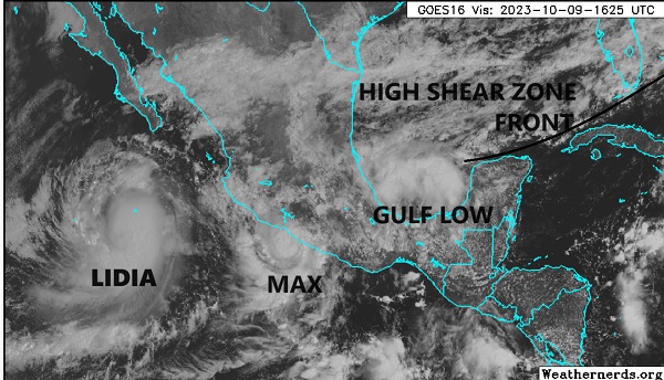
A small area of tropical-ish low pressure has developed in the southwestern Gulf of Mexico and is being drawn slowly northward this morning, presently centered roughly 120 or so miles north of Coatzacoalcos, Mexico.
This Low is not yet Invest tagged, but soon may be. Regardless of an Invest tag or not, the disturbance is set to become part of a complex weather event that combines several other features: East Pac Lidia and East Pac Max that are both heading eastward, a stalling front draped across the southern Gulf, and an abundance of high shear near and possibly soon over whatever this tropical-ish low becomes.
Just what this incipient cyclone becomes at the moment is too early to say, but NHC did go ahead and flag it with an opening bid of a possibly conservative 20% odds for becoming a tropical cyclone within the next 48 hours, before likely merger with those other features.
While not likely to itself make landfall as a tropical storm, it does seem likely to enhance heavy weather impacts along and just inland in the Gulf Coast states from south Texas all the way to Florida, and if it wasn't for this feature having a real chance of being named before being absorbed, I would have elected to move this thread to another forum.