| cieldumort |
| (Moderator) |
| Fri Nov 08 2024 12:03 PM |

|
|
|
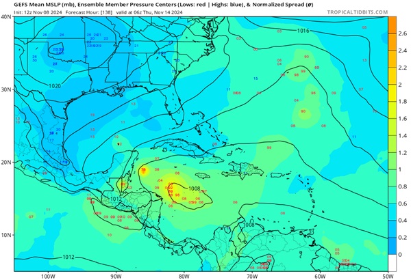
Models and ensemble members are increasingly warming up to the idea that a broad area of low pressure will form in the central to western Caribbean or across Central America later this coming weekend or next week, and out of this region a tropical cyclone could develop as soon as early next week to around the middle of the month. Generally, operational and ensemble member runs suggest about a 40% chance of TC genesis in this region, which would immediately be landlocked, and as such, we are starting a Lounge on this modeled feature.


An area of enhanced showers and thunderstorms associated with one of the approaching tropical waves set to interact with the developing broad area of low pressure in the Caribbean is continuing to show more early indications of TCG potential and is likely to become the center of focus for the next Invest tag to be assigned. The title will be updated accordingly.
2024-11-11 20z
The area of interest we are tracking has just been Invest tagged 99L and the title has been updated accordingly.
2024-11-12-18z
Potential Tropical Cyclone Nineteen
4:00 PM EST Wed Nov 13
Location: 16.2°N 79.0°W
Moving: W at 6 mph
Min pressure: 1007 mb
Max sustained: 30 mph
Sara 11-14-24 1PM CDT
Ciel
| cieldumort |
| (Moderator) |
| Mon Nov 11 2024 11:56 AM |

|
|
|
More models and their ensembles are now latching on to the idea of a broad area of low pressure forming this week in the central to western Caribbean, ramping up a TC over the course of the next several days. A few runs have been very aggressive, as conditions for Rapid Intensification still exist off and on in this region.
A series of waves approaching from the east are likely to interact with the general gyre setup, and it seems likely at least one of them should help trigger this anticipated Tropical Cyclone Genesis. Depending on just where genesis occurs, should it occur, will have substantial influence on any future track and intensity, but the general consensus is for either
Weaker > west to northwest (crossing central America into the east pac):
W into central America, possibly as a strong storm
NW towards the western gulf, being battled by inhospitable conditions much the same was as Rafael, but perhaps still a brief HUR then storm
Stronger > north to northeast (threatening Cuba and perhaps south Florida and the Bahamas):
N to NE with RI in the northern Caribbean as it passes over or near Cuba, possibly to track into the Florida Straits
Recon will probably be tasked this week and thus models will fine tune and most likely come into better agreement.
| cieldumort |
| (Moderator) |
| Tue Nov 12 2024 12:39 AM |

|
|
|

Above: Invest TBD in the north-central Caribbean tracking west to merge with a broader region of low pressure and favorable environment for further, quite possibly rapid development, later this week into next.
No vort-centric models are available yet. Here are some summaries of the 12/0z Globals that have locked on to this developing cyclone:
ICON
Apparent TD by Thursday in W Carib. Storm by Friday. HUR by Sunday. Major by Monday while tracking nw towards Yucatán. Scrapes/rounds Yucatán Monday as a Major. Enters south-central GOM by Tuesday (end of run)
GFS
Apparent TD by Wednesday evening sw of Jamaica. Storm Thursday just east of Nicaragua/Honduras. HUR Friday closer to Nic/Hon border tip. Major by Sat while still east Nic/Hon... meanders.. Cat 4 in this area by Sunday night. Tracks NW-NNW and enters Gulf between Yucatán and Cuba on Tuesday still Cat 3/4. Landfall around Naples-Fort Myers as Cat 3 Wed Nov 20th. Exits Fl on 21st, hooks ESE and rakes Bahamas Thurs and Fri Cat 2/1/Storm on weakening trend.
ECMWF
Apparent TD by Thursday ne of Nicaragua/Honduras border. Storm Friday N of Honduras. HUR by Sun while east of Nicaragua/Honduras border. Meanders, then beings tracking northwest and Majors Monday. Approaches the Yucatán Channel Tuesday night as a Cat 4/5. Landfall on western Cuba Wednesday night as a Major in the 3-4 range, perhaps. Tracks across western Cuba through end of run. Devastating solution for Cuba, if verified.
More details to come. This feature has the potential to become a very rare late-season landfalling Major hurricane.
| IsoFlame |
| (Weather Analyst) |
| Tue Nov 12 2024 01:14 PM |

|
|
|
Quote:
More details to come. This feature has the potential to become a very rare late-season landfalling Major hurricane.
Every model run lately is backing this up, and the GOES east Caribbean loop is signaling the potential for TC formation.
| cieldumort |
| (Moderator) |
| Tue Nov 12 2024 02:10 PM |

|
|
|
99L Initialized
Synoptic Time: 2024-11-12 18:00
Lat: 16.9
Lon: -76.5
Intensity: 20
| JMII |
| (Weather Master) |
| Tue Nov 12 2024 07:00 PM |

|
|
|
Quote:
Landfall around Naples-Fort Myers as Cat 3 Wed Nov 20th.
Lord no… I am scheduled to close on a home in Cape Coral on Monday the 18th
 we purposely waited till mid November to avoid major hurricanes.
| cieldumort |
| (Moderator) |
| Wed Nov 13 2024 09:51 AM |

|
|
|

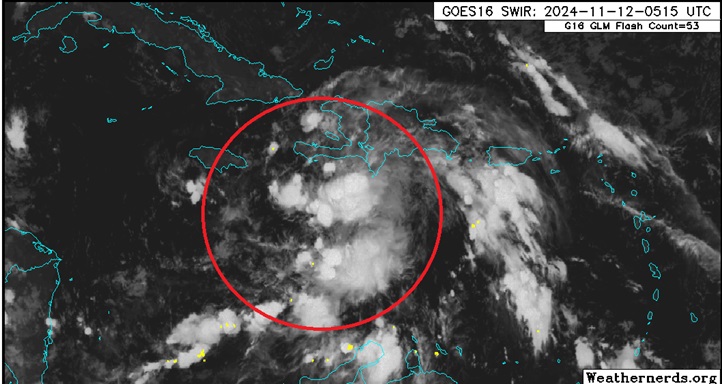
Caribbean Gyre with three distinct lobes. Invest 99L most prominent (Circled in red). Base map credit: Zoom Earth
First light this Wednesday morning paints a bit of a complex picture for the future of our developing Invest. Invest 99L itself may be recentering a hair to the southeast of where Best currently has it. What was likely the rounding tip of one of the triggering tropical waves has begun closing off itself, and then just to the north of Honduras and east of Belize is a formerly naked, well-defined and closed off low.
These three competing lobes all now orbiting within a gyre could somewhat hamper the formation of Sara and modify her future track in ways not yet very well modeled. In fact, while not mentioned by NHC, there is probably a chance that the well-defined and now somewhat convectively active closed low east of Belize acquires sufficient organization that it becomes a TC itself, provided it stays over water.
Recon has been tasked and will start providing invaluable data. At present, there is a lot of spread among the models and their ensembles.
| IsoFlame |
| (Weather Analyst) |
| Wed Nov 13 2024 11:36 AM |

|
|
|
12Z GFS backed off on a strong Caribbean TC ever entering the GOMEX given the circulation's proximity/interaction with land. Then a strong cold front clears the slate by shunting whatever is left off to the southeast, well south of Florida peninsula.
| vineyardsaker |
| (Weather Guru) |
| Wed Nov 13 2024 03:34 PM |
|
|
|
|
please forgive my primitive question, but are you saying that it looks like this system will not impact Florida? if so, how confident are you in this prediction?
thank you!
| JMII |
| (Weather Master) |
| Wed Nov 13 2024 04:09 PM |

|
|
|
Its labeled as PTC #19 now and they have going into Belize where it could fall apart. The approaching cold front is pretty strong, which should hamper developement next week. However a few of the models are still trying to get it cranked up the gulf. The model trend has more W with a stall, then swinging back NE but with such a sharp turn to the point where it now stays S of the FL Keys. During this run it never gets above Cat 2 intensity. This would be very good news for FL, especially the beat down west coast.
| vineyardsaker |
| (Weather Guru) |
| Wed Nov 13 2024 05:24 PM |
|
|
|
|
thank your for your clarifications!
| cieldumort |
| (Moderator) |
| Wed Nov 13 2024 09:01 PM |

|
|
|
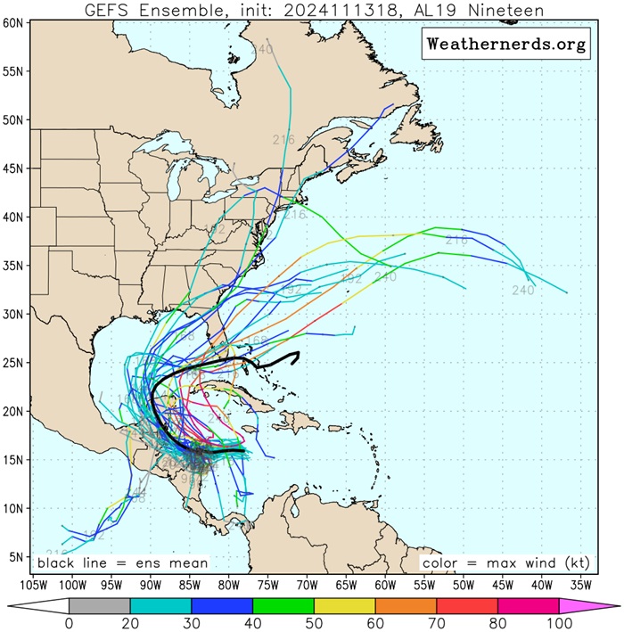
Among the ECMWF and GFS ensemble members, there is a clear pattern of tracking towards Florida if NINETEEN ramps up quickly and begins pulling poleward without running into land early. This solution is in the minority as of 18z. Most members show the cyclone taking longer to ramp up, and thus tracking more westerly early on, consequently also running into and over land for longer, with little substantial recovery if and when once in the Gulf.
Without having had the benefit of any recon missions today or microwave passes of any real quality, it is difficult yet to discern which solution is more likely. Recon should be in NINETEEN tomorrow, however.
Based on IR and pseudo-VIS satellite imagery, the system may be trending west-southwesterly, in the general cyclonic flow of the regional gyre.
18z ECWMF and GFS ensemble members below credit Weathernerds.org


| JMII |
| (Weather Master) |
| Thu Nov 14 2024 01:35 PM |

|
|
|
Being weak and over land for such a long time should result in Sara dying out. Most models agree she is now longer going to be a major hurricane, more like TS or maybe Cat 1. The environment in Gulf is not going to be storm friendly with high levels of shear.