| cieldumort |
| (Moderator) |
| Wed Aug 16 2023 02:33 PM |

|
|
|
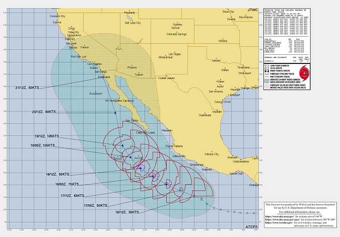
Above: Initial official forecast and forecast track for Hilary as of 08/16/23/1200z.
Hatched region denotes 34KT wind danger area/USN ship avoidance area.
Forecast from NOAA and graphic has been reformatted. NRL.
Tropical Storm Hilary has formed in the very active, El Niño-fueled eastern Pacific, and is officially forecast to head towards southern California. Water temps along the coasts of Baja and California are considerably warmer than average, and conditions overall for development will likely make Hilary a Major by Saturday. In fact, Hilary could even enter the southwestern United States still a bona fide tropical cyclone.
Whether or not Hilary maintains itself as a tropical cyclone into the US, her remnants could easily deluge normally very dry parts of the country that will not absorb the unusually copious rains, with flash flooding likely. In fact, the main threat from Hilary in the US could continue with very high levels of moisture rounding the Heat Dome, pushing ENE to NE.
On its initial official forecast, winds will likely be howling at higher elevations and into canyons within portions of the southwestern U.S., possibly gusting to hurricane-force.
Disclaimer to all the above, forecast errors can be large.
The title has been edited to reflect the most recent official NHC forecast that explicitly shows Hilary still intact as a 60 MPH tropical cyclone over Los Angeles, CA. - Ciel
| cieldumort |
| (Moderator) |
| Wed Aug 16 2023 03:51 PM |
|
|
|
|
Hilary GFS Ensemble forecast initialized 08-16-23-12z
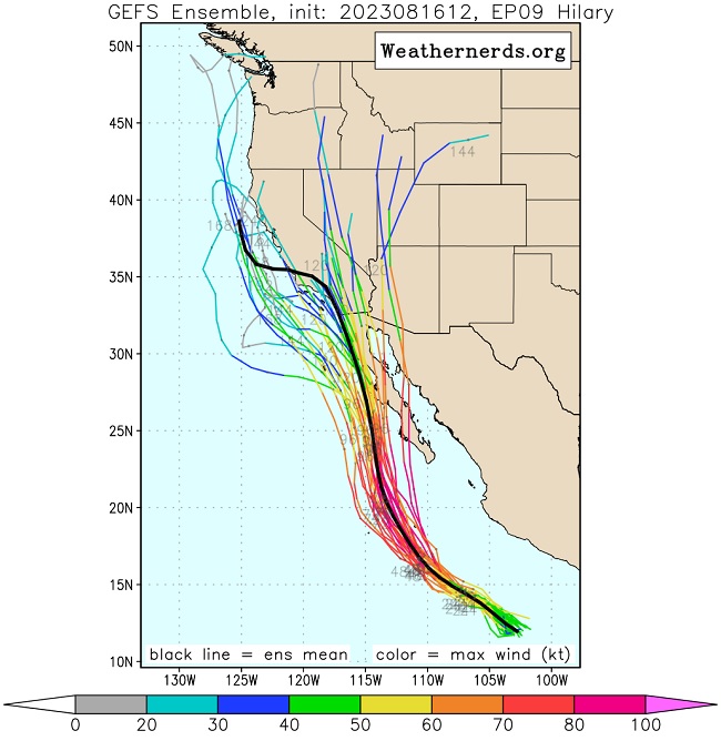
Credit: Weathernderds.org
Hilary ECMWF Ensemble forecast initialized 08-16-23-12z
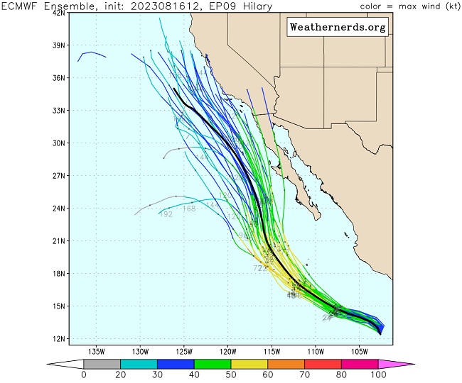
Credit: Weathernerds.org
MikeC
|
| (Admin) |
| Fri Aug 18 2023 09:24 PM |
|
|
18z HWRF has hilary landfalling right at Malibu. Hmon, Huntington Beach, HAFS-A and B south of TIjuana in the Baja
The 18z gfs huntington beach also
| cieldumort |
| (Moderator) |
| Sat Aug 19 2023 09:27 PM |
|
|
|
|
Lift and frontal boundaries/convergence zones courtesy the closed upper-level low off the California coast are conspiring with Hilary to enhance rainfall and strong thunderstorms with damaging wind gusts well ahead of Hilary even crossing into the state.
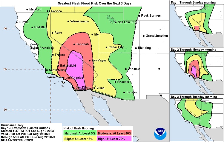
This pre-soaking may cut both ways, being that on the one hand it will help soften up some ground that may have otherwise lead to rapid runoffs because the ground being unable to absorb water. On the other, some of these rapid runoffs may now occur sooner than later, and at some point grounds will reach a saturated level. The potential for over a foot of rain in some locations, with widespread 1" to 4" occurring over so much other real estate where that is more like a month or two's worth of rain, will easily place portions of California, Arizona, Nevada and destinations yet to come at a severe risk for potentially locally catastrophic flooding.
| cieldumort |
| (Moderator) |
| Sun Aug 20 2023 08:38 PM |
|
|
|
|
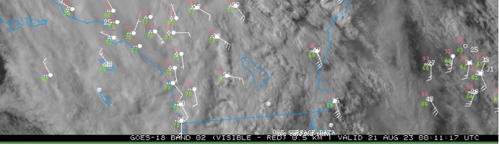
A surface circulation center near or over Huntingon Beach, CA 8/21/23/0011z indicating there may have been a jump, albeit perhaps only temporary, west of forecast track.
| cieldumort |
| (Moderator) |
| Sun Aug 20 2023 11:33 PM |
|
|
|
|
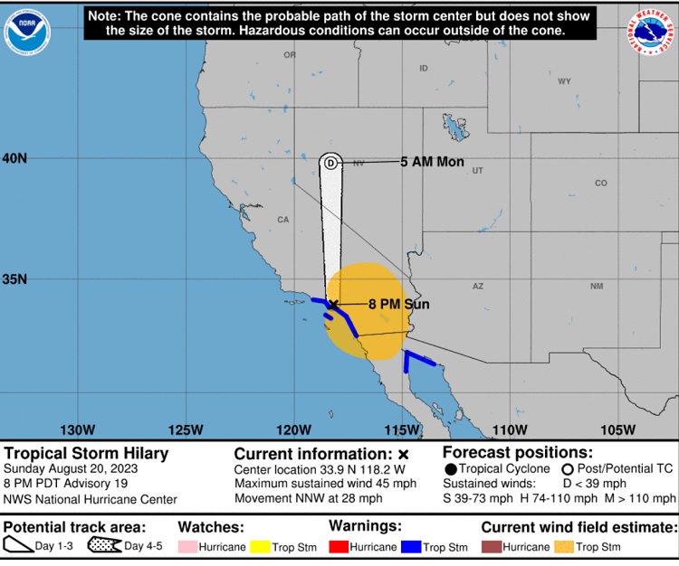
Hilary did indeed get jumpy and an apparent official center relocation is on the 8PM Advisory
| cieldumort |
| (Moderator) |
| Wed Aug 23 2023 04:00 PM |
|
|
|
|
Nevada, Oregon, Idaho, Montana