| cieldumort |
| (Moderator) |
| Wed Sep 23 2026 09:58 PM |

|
 Hurricane Polo |
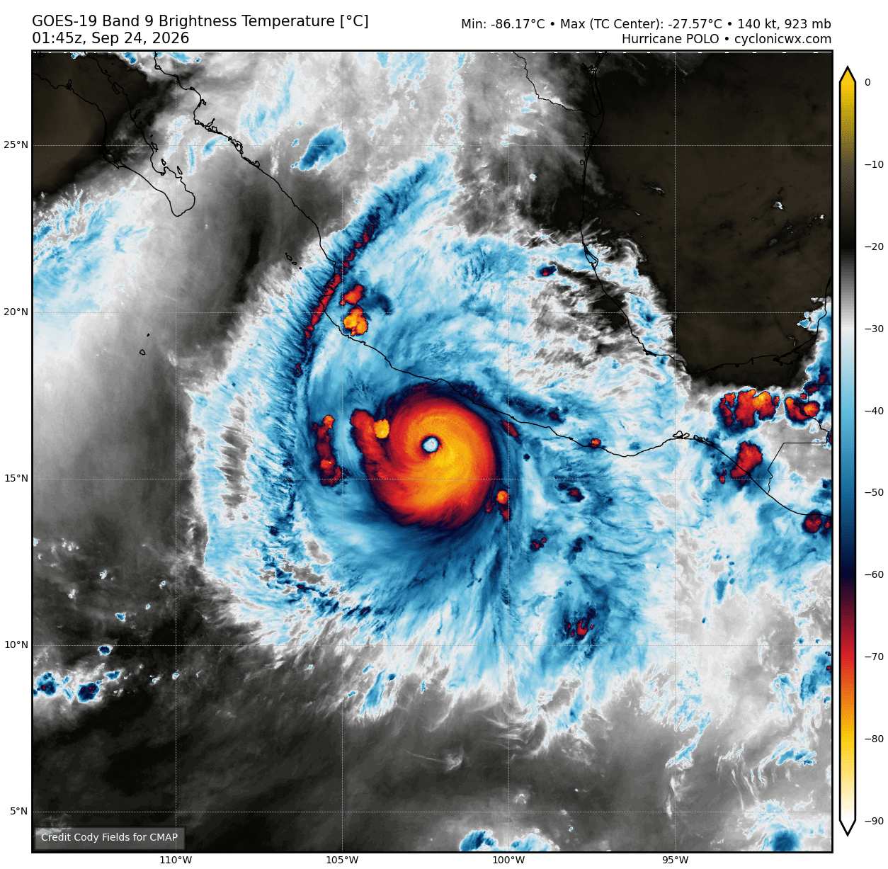
Major Hurricane Polo, now a Category 5 for the second time in as many days, has already been helping pump up copious moisture into the southwestern US, resulting in several areas of significant rainfall and necessitating flash flood watches and warnings, while still well south of even the Baja. However, models are increasingly trending on tracks that could have the cyclone loop back towards Mexico and possibly even the southwestern US next week, and we are starting a de facto Lounge on this powerhouse tropical cyclone at this time.
More to come
| cieldumort |
| (Moderator) |
| Thu Sep 24 2026 12:19 AM |
|
|
|
Re: Polo (Cat 5 Presently) Already Impacting SW US
|
Latest 0z runs of Globals + Hurricane Models on Polo.
These tracks are largely cut short not necessarily from implied decay, but rather how many hours these models' runs go for.
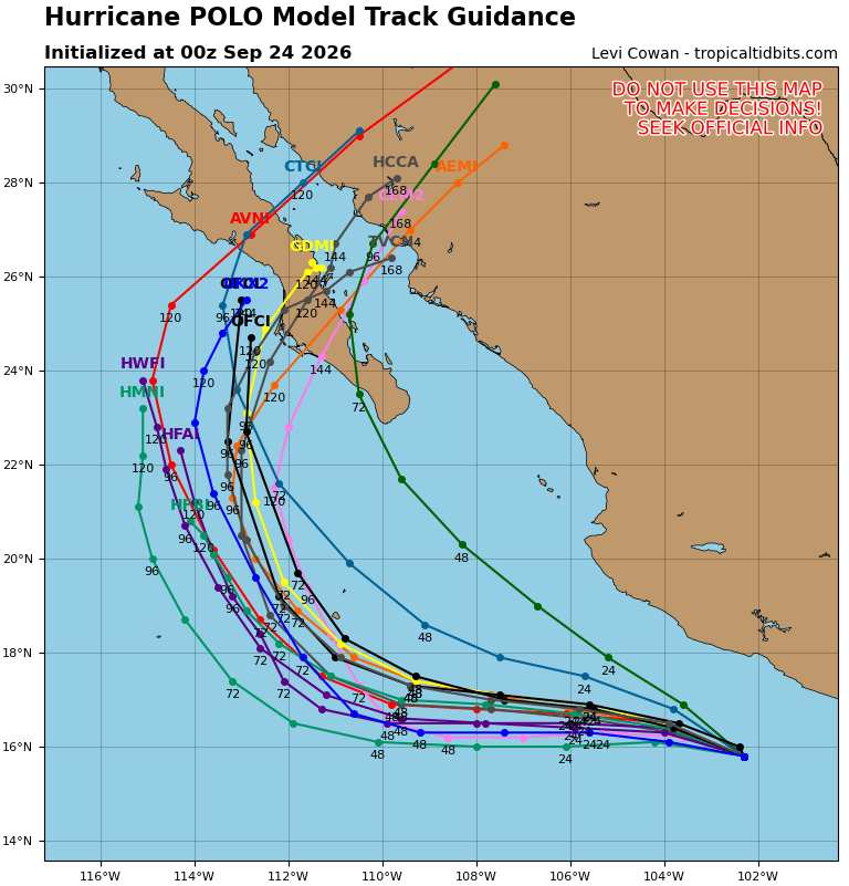
General consensus that Polo will recurve to the northeast, into and crossing the Baja, into and crossing the Gulf of California and into and potentially through Sonora and/or Chihuahua, MX.
| cieldumort |
| (Moderator) |
| Thu Sep 24 2026 01:00 AM |
|
|
|
Re: Polo (Cat 5 Presently) Already Impacting SW US
|
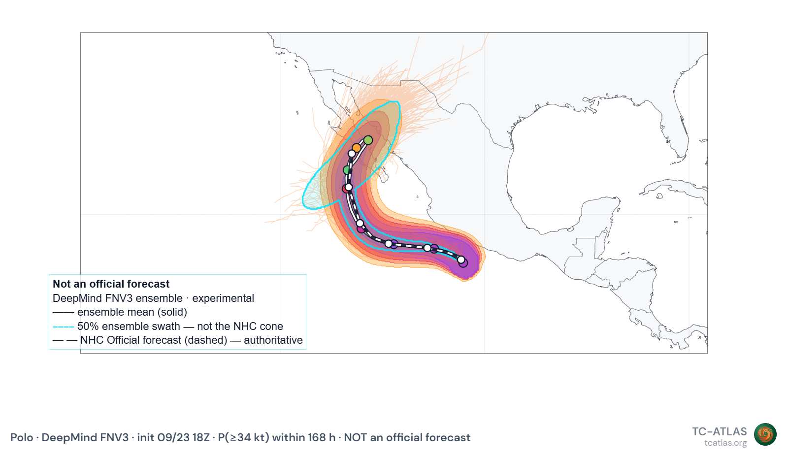
Today's 18z FNv3 ensembles/swath for Polo out to 168 hours suggests a fairly high degree of uncertainty still exists out past roughly day among the DeepMinds
| cieldumort |
| (Moderator) |
| Sun Sep 27 2026 11:47 PM |
|
|
|
Re: Hurricane Polo
|
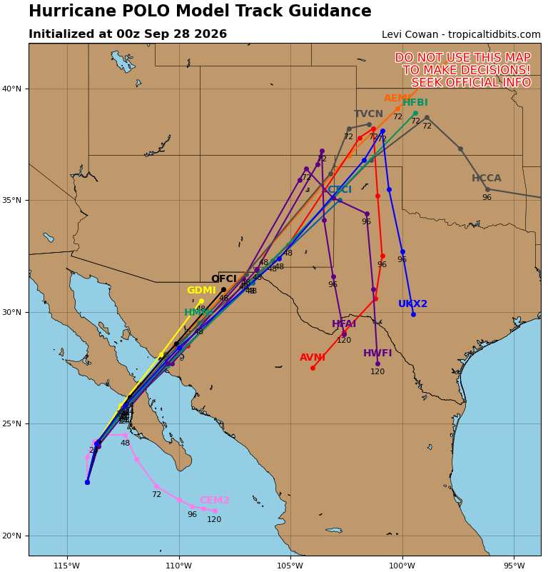
Collection of the most recent 0z runs of Globals + Hurricane Models
Credit: TropicalTidbits
| cieldumort |
| (Moderator) |
| Mon Sep 28 2026 12:09 AM |
|
|
|
Re: Hurricane Polo
|
Excessive Rainfall Discussion
NWS Weather Prediction Center College Park MD
835 PM EDT Sun Sep 27 2026
Day 1
Valid 01Z Mon Sep 28 2026 - 12Z Mon Sep 28 2026
...THERE IS A MARGINAL RISK OF EXCESSIVE RAINFALL FOR PARTS OF THE
NORTHEAST, PARTS OF THE HILL COUNTRY TO NORTH-CENTRAL TEXAS, AS
WELL AS PARTS OF WESTERN ARIZONA AND SOUTHEAST CALIFORNIA...
Previous discussion..
...Texas...
A surge of moisture, the leading edge of a multi-day low level jet
which will fuel a multi-day heavy rainfall event in this area, will
begin to advance northward from off the Gulf and into the Southern
Plains today. Upper level ridging and a distinct lack of forcing
will put a cap on any significant rains today. However, along
frontal boundary/interface, a few isolated storms can't be ruled
out, especially along the Balcones Escarpment, where topography
oriented perpendicular to the southeasterly flow may allow for a
stationary storm or two. Into north central Texas, it will be the
warm frontal interface having to do all the work to cause any
storms capable of flash flooding. Soils remain well drier than
normal, so this is a very low-end Marginal, with only an isolated
instance of flash flooding or 2 possible. The inherited Marginal
was left largely unchanged, save for a few very minor tweaks in
southern Oklahoma.
...Western-Northern Arizona and Southeast California...
0100Z Update: Mid/upper level moisture plume from Post-Tropical
Odalys, along with mixed-layer CAPEs around 500 J/Kg, is allowing
for an uptick in shower activity across SE CA into western and
northern AZ. Probabilities of .50"/hr rainfall rates remain low per
the 18Z HREF and REFS, however the guidance does show an uptick
towards 12Z. As such, we merely shifted the previous outlook area
westward, while expanding it a bit.
Hurley
Previous discussion below..
The beginning of a surge of moisture associated with the upper half
of East Pacific Tropical Storm Odalys will move into the Southwest
today. Ingredients for a multi-day heavy rain and flash flooding
event across the Southwest, which will unfold over the coming days,
will only begin to come together today. Thus, while widely
scattered showers and storms are likely, resultant flash flooding
should be isolated at best. No significant changes were made from
inherited.
Wegman
Day 2
Valid 12Z Mon Sep 28 2026 - 12Z Tue Sep 29 2026
...THERE IS A MODERATE RISK OF EXCESSIVE RAINFALL FOR PORTIONS OF
THE SOUTHWEST/FOUR CORNERS...
...2030Z Update...
...Southwest...
No major changes were needed with the afternoon update today. The
PRE from the combination of Odalys and the approach of Polo is
still expected to produce a widespread 1-3 inches of rain across
the Four Corners Region, where most soils are already at or near
saturation from recent heavy rainfall. The Moderate Risk forks a
bit further south in New Mexico to include the Lordsburg, NM area,
where numerous burn scars are, and to include the rest of the
Sacramento Mountains in south-central Colorado. Some minor tweaks
were made to the surrounding Slight, but since there haven't been
major changes to the track, and the flow will be uniformly out of
the southwest, south and west facing slopes along the Mogollon Rim,
and the San Juans are likely to see the most rainfall. Rocky soils,
burn scars, and slot canyons will all locally exacerbate any
flooding from the widespread rainfall.
Wegman
...Previous Discussion...
...Southwest/Four Corners...
A predecessor rainfall event (PRE) is likely to impact much of the
region beginning by midday and continue into the end of the
period. Moisture preceding the arrival of the primary moisture
plume associated with Hurricane Polo will continue to spread across
the region as it is drawn northeastward ahead of a mid-to-upper
level low digging south across California toward the lower Colorado
Basin.
As PWs increase to 2-3.5 std dev above normal across much of the
region, strong upper level divergence combined with amplified
southwesterly flow orthogonal to the terrain will support
significant synoptic and orographic forcing.
A limiting factor will be instability, hampered by thick cloud
cover and shortening daylight. However, the strong forcing and
anomalous moisture is likely to support very efficient warm-rain
processes that will compensate for the limited CAPE.
A broad Moderate Risk remains in place -- covering the complex
terrain and burn scars of southern Utah, southwestern Colorado, as
well as much of northern and central Arizona and New Mexico. One
smaller adjustment this issuance was to extend the Moderate Risk a
bit farther southeast into the extremely vulnerable areas of
southeastern New Mexico, where soils remain nearly saturated from
recent rounds of heavy rain.
https://www.wpc.ncep.noaa.gov/discussions/hpcdiscussions.php?disc=qpferd
| cieldumort |
| (Moderator) |
| Mon Sep 28 2026 12:28 AM |
|
|
|
Re: Hurricane Polo
|
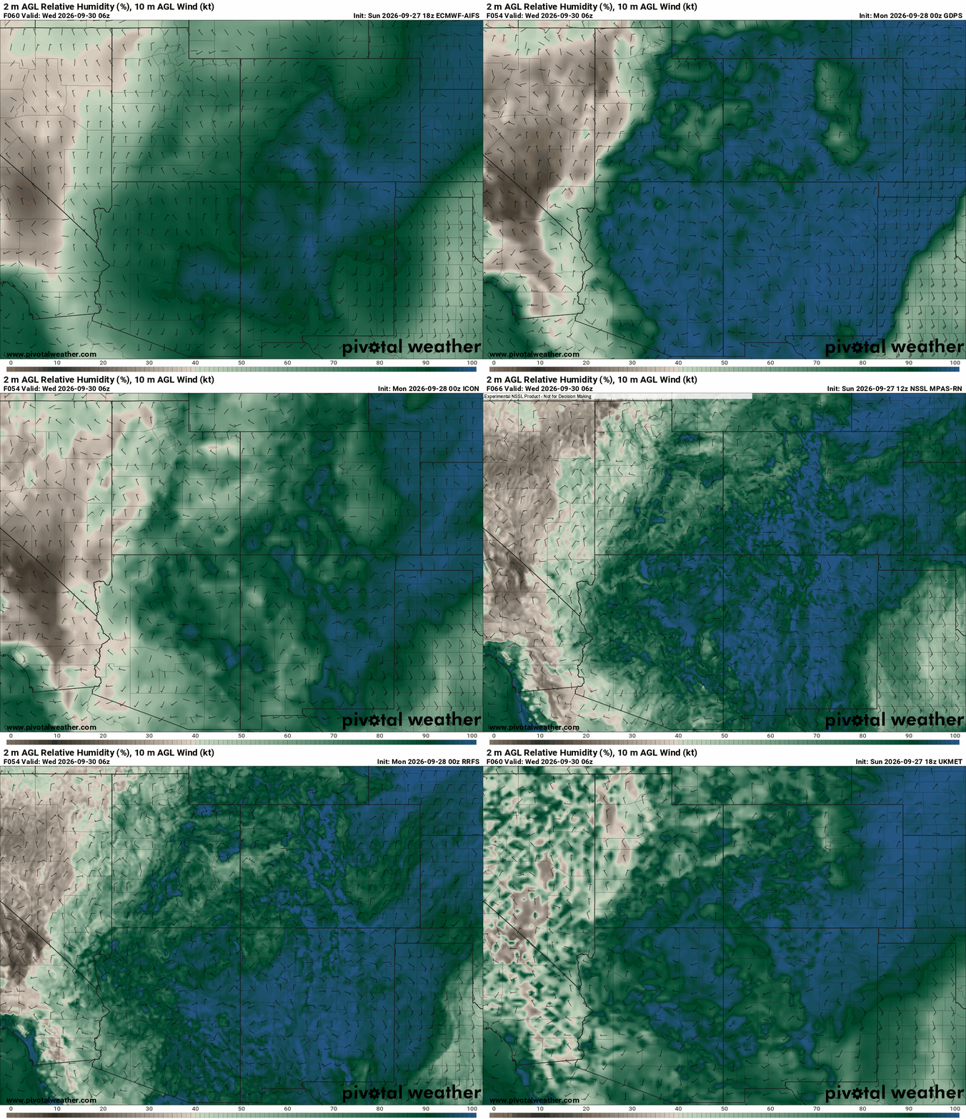
Most recent Globals+CAMS forecast valid 06z Wednesday for surface (2-meter) relative humidity and wind speed+direction (barbs).
These runs forecast an incredible amount of moisture for this part of the country with relative humidity at or near 100% over a very large area.
| cieldumort |
| (Moderator) |
| Tue Sep 29 2026 01:13 AM |
|
|
|
Re: Hurricane Polo
|
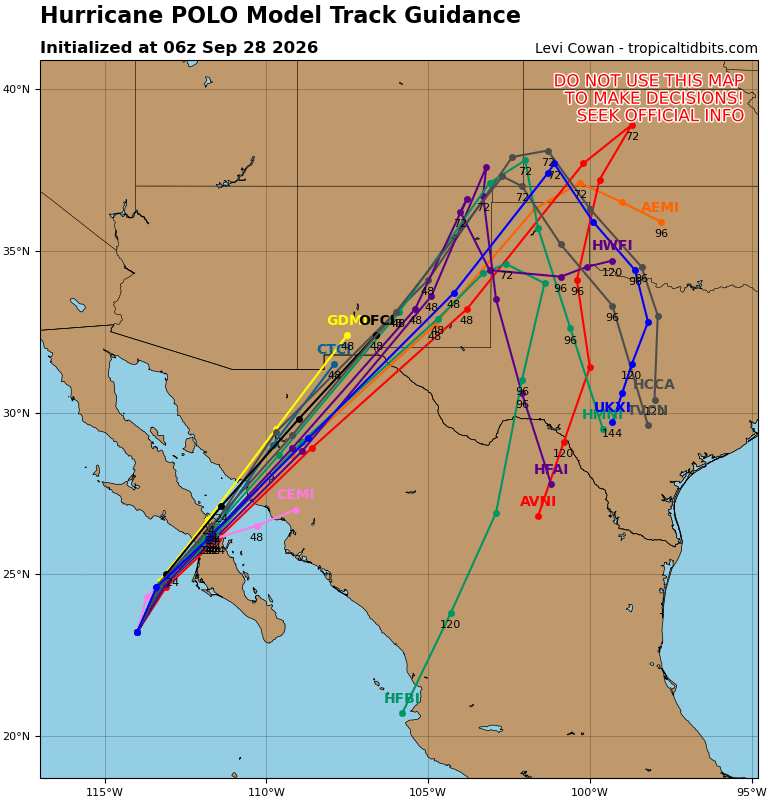
Most recent Globals + Hurricane Model runs on Polo
Note that a lot of these runs that show Polo well in to the United States are tracking remnant or post-tropical cyclone low pressure and not necessarily Polo as a still-intact tropical cyclone. Polo's interaction with the approaching upper-level low and dynamics related to terrain are still likely to result in an area of low pressure almost if not indistinguishable from an inland tropical cyclone with regard to impacts, regardless, and there is still some chance that Polo maintains as a TC into the US
06z Track Suite
06z Intensity Suite
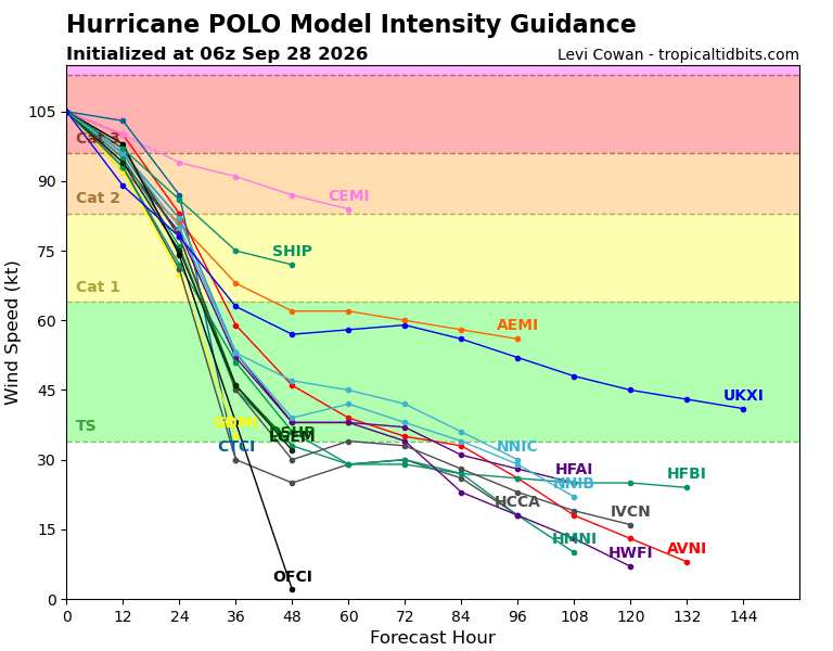
OFCI is the official NHC forecast, which is well below the model guidance as can be seen above, and could be on the conservative side
| cieldumort |
| (Moderator) |
| Tue Sep 29 2026 02:11 AM |
|
|
|
Re: Hurricane Polo
|
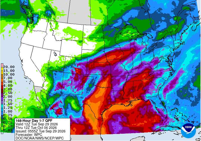
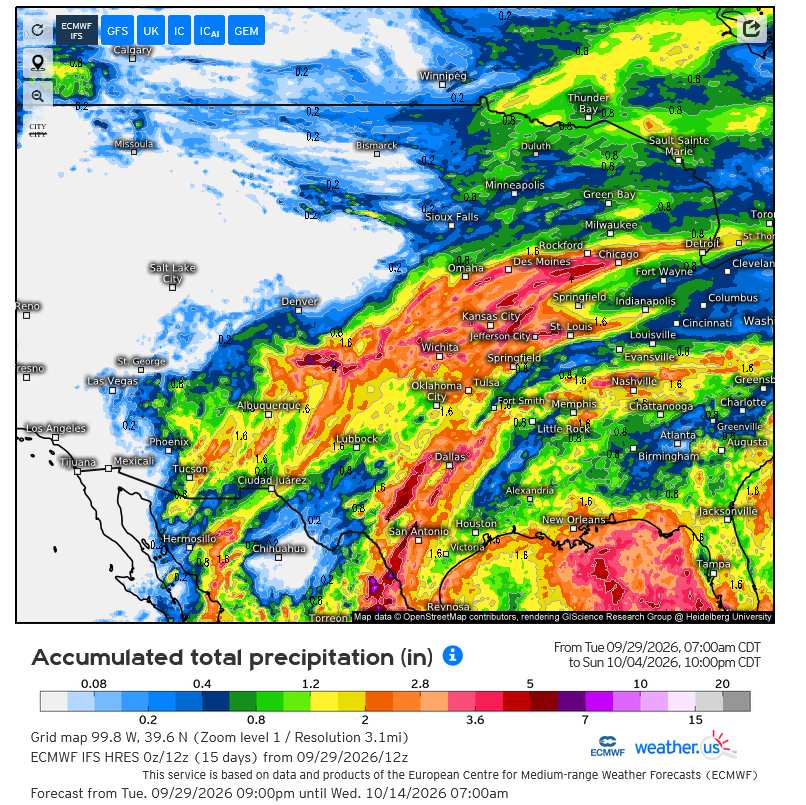
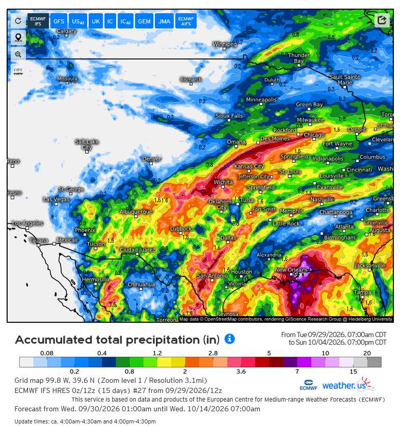
Local maxima can easily be double or more what is shown above. There is a particular risk of training setting up across portions of Texas and Oklahoma this week and are the type of events that can sometimes lead to feet of rain and flash flood emergencies.
| cieldumort |
| (Moderator) |
| Tue Sep 29 2026 09:22 PM |
|
|
|
Re: Hurricane Polo
|
ECMWF IFS HRES runs help give a range of plausible outcomes for this Polo-energized significant rain and flood event
Here are three possible scenarios within reason
MASTER
MEMBER 27
MEMBER 39
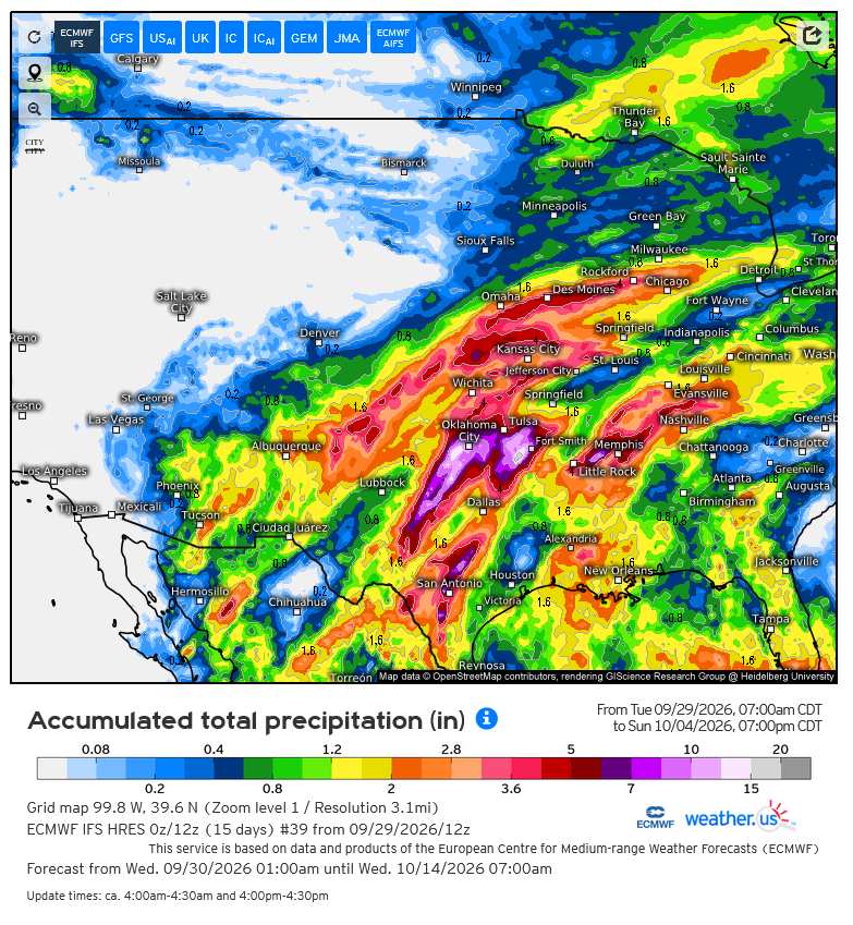
Credits: Weather.us/ECMWF