| IsoFlame |
| (Weather Analyst) |
| Mon Sep 26 2022 06:13 AM |

|
|
|
Started the thread this morning in anticipation of deteriorating conditions throughout central Florida as Ian approaches the west coast.
9/26 @ 6am: 78F, partly cloudy, calm.
A good link to monitor weather condition throughout the state is the
Regional Weather Roundup
| Southern4sure |
| (Weather Guru) |
| Mon Sep 26 2022 07:11 AM |

|
|
|
Thank you for the thread. I live in Land O Lakes, FL which is about 30 minutes North of Tampa and about 30-45 minutes from the Gulf. I’m sure it’s about to get nasty here.
| IsoFlame |
| (Weather Analyst) |
| Mon Sep 26 2022 08:26 AM |
|
|
|
|
Roger that. here is a good link to follow Ian conditions in the eastern GOMEX (click on Gulf of Mexico(East)/Florida:
Data Buoy Observations
| Tazmanian93 |
| (Weather Master) |
| Mon Sep 26 2022 10:23 AM |

|
|
|
Hillsborough County officials have announced a mandatory evacuation for everyone in Zone A. They have also recommended a voluntary evacuation for residents in Zone B #HurricaneIan
| Southern4sure |
| (Weather Guru) |
| Mon Sep 26 2022 10:51 AM |
|
|
|
|
Thank you. I’ll definitely use this.
| Tazmanian93 |
| (Weather Master) |
| Mon Sep 26 2022 11:45 AM |
|
|
|
|
Pinellas Suncoast Transit Authority (PSTA) said it will suspend all transit services on Wednesday, September 28th, but could be enacted earlier if winds are sustained at 40 miles per hour Tuesday evening. The suspension will include all PSTA routes including PSTA Access, the Jolley Trolley, and Looper services.
Gov. Ron DeSantis announced during a press conference that Florida tolls in the Tampa Bay area have been suspended.
| JMII |
| (Weather Master) |
| Mon Sep 26 2022 01:04 PM |

|
|
|
Not my area but a PWS in George Town on Grand Cayman https://www.wunderground.com/dashboard/pws/I90580545 is showing 40 MPH gusts with Ian 90 miles due west. So for now the storm is pretty compact.
| IsoFlame |
| (Weather Analyst) |
| Mon Sep 26 2022 01:37 PM |
|
|
|
|
A good Bay area source of open discussion regarding Ian's impact, with opportunity for Q/A:
Max Defender 8 Live WFLA
also available streaming live on YouTube
| Southern4sure |
| (Weather Guru) |
| Mon Sep 26 2022 03:15 PM |
|
|
|
|
Pasco County Commissioners approved a state of emergency Monday afternoon and announced that evacuations in zones A, B and C, which includes everyone west of U.S. 19 and some neighborhoods to the east, should begin Tuesday morning when shelters open.
| Tazmanian93 |
| (Weather Master) |
| Mon Sep 26 2022 03:41 PM |
|
|
|
|
Emergency officials in Pinellas County have ordered mandatory evacuations for residents in Zone A effective at 6 p.m. tonight. Residents in Zones B and C will be ordered to evacuate tomorrow at 7 a.m.
| OrlandoDan |
| (Weather Master) |
| Mon Sep 26 2022 05:52 PM |

|
|
|
Orange and Osceola schools closed Wednesday and Thursday. Waiting to hear on Seminole.
| MichaelA |
| (Weather Analyst) |
| Mon Sep 26 2022 10:29 PM |

|
|
|
In a passing thundershower at my home today, got a wind gust to 20.6 mph at 6:02 PM. That was mostly due to the high level outflow of Ian causing a lifting situation. Tops were blowing off to the NE while motion of the thundershowers was to the SW. Actual outer bands should begin affecting my home’s location tomorrow evening. I’m currently on vacation in northern NY, returning home on October 6. Link to my weather station is below.
| JMII |
| (Weather Master) |
| Mon Sep 26 2022 11:18 PM |
|
|
|
|
Steady rain here in NW Broward got .7 to .8†total for today.
| Tazmanian93 |
| (Weather Master) |
| Tue Sep 27 2022 09:23 AM |
|
|
|
|
Treasure Island Police are now limiting traffic onto Treasure Island.
The following citizens will have access to barrier islands:
Residents
Property Owners
Business Owners
Business Employees
Contractors
| Mike V |
| (Weather Watcher) |
| Tue Sep 27 2022 09:43 AM |
|
|
I'm in Cape Coral, what we are getting right now is light winds and very light sprinkle. I'm not evacuating as this house has never had a flood claim going back to 1978.
| IsoFlame |
| (Weather Analyst) |
| Tue Sep 27 2022 10:00 AM |
|
|
|
|
Quote:
Steady rain here in NW Broward got .7 to .8†total for today.
Wow!! That's more than I recorded in August and September (to date).
It's been nearly 2 weeks since my location has had a good soaker (1" or more), and I'm currently running a wet season deficit of 6", so hoping for a soaking rain (if it comes over several days!).
Sandbags are ready to block floodwaters from coming into front yard off roadway and house. The nearby intersection regularly floods during heavy thunderstorms given the County's poorly designed storm drain system and lack of stormwater retention at upstream business parking lots (that are over 5' higher than my ground floor's 11' elevation) to the east on South Atlantic Avenue (A1A).
| JMII |
| (Weather Master) |
| Tue Sep 27 2022 11:23 AM |
|
|
|
|
Quote:
I'm in Cape Coral, what we are getting right now is light winds and very light sprinkle. I'm not evacuating as this house has never had a flood claim going back to 1978.
11AM update shifted the cone slightly SE, its covers as far south as Bonita Springs now. Ian has been tracking on the eastern edge of the cone but the NHC still has movement as N (5 degrees). They have upped the forward motion, putting landfall 6-12 hours sooner.
Steady to brief heavy rain for me, since midnight we've gotten an 1.5" more. No wind to speak off but during breaks in the rain you can see the clouds moving quickly SE to NW. Broward is now under a TS watch and schools have been canceled for tomorrow.
| IsoFlame |
| (Weather Analyst) |
| Tue Sep 27 2022 12:26 PM |
|
|
|
|
Just measured 0.84" from heavy,,then moderate isolated shower (no lightning or wind) that started 11am and ended noon... This is the greatest 24-hr rainfall total since a little over an inch fell a month ago on August 27th... Just what was needed.to soften up the dry ground for my CoCaHaRs station: FL-VL-42 in anticipation of much more.
| Mike V |
| (Weather Watcher) |
| Tue Sep 27 2022 08:03 PM |
|
|
Hi, I got out of dodge. That eastern movement along with the increase in surge was enough to tip the decision. Now in homestead.
| JMII |
| (Weather Master) |
| Tue Sep 27 2022 08:17 PM |
|
|
|
|
Quote:
Hi, I got out of dodge. That eastern movement along with the increase in surge was enough to tip the decision. Now in homestead.
Smart move I think.
Right now Broward is getting slammed with strong rain, thunder and multiple tornado warned cells. Possible small, fast tornado might have moved thru the Cooper City area. Another one might have been out west between Parkland and US27 based on radar signature. My phone is blowing up with warnings, I don't think I have ever had this many before: tornado, severe weather, TS, flood watch.
Up to 2.4" of rain today so far.
| Owlguin |
| (Weather Hobbyist) |
| Tue Sep 27 2022 09:13 PM |
|
|
SE Palm Beach County, constant tornado warnings and storms moving through with thunder and lightning.
| Stork |
| (Verified CFHC User) |
| Tue Sep 27 2022 10:53 PM |

|
|
|
Martin County is now in on the action that Broward and Palm Beach counties have been experiencing: downpours, thunder, lightning, tornado warning. I think when it’s all said and done we will exceed the pre-storm rainfall estimates.
| OrlandoDan |
| (Weather Master) |
| Wed Sep 28 2022 07:41 AM |
|
|
|
|
Slow, steady, drizzly rain here in SW Seminole county.
| Southern4sure |
| (Weather Guru) |
| Wed Sep 28 2022 08:46 AM |
|
|
|
|
Light and steady rain here in Pasco County, (West Central Florida)
| JMII |
| (Weather Master) |
| Wed Sep 28 2022 09:22 AM |
|
|
|
|
Rainy and breezy in NW Broward this AM. Winds ESE 15 gusting to 25. Over night several tornadoes were confirmed. Rainfall total is 3.6". As Ian is 145 miles due west of my location I assume unless we get a particularly nasty feeder band this about all I see from this storm thankfully. The few rain bands I see on radar are drying up before they reach me.
| OrlandoDan |
| (Weather Master) |
| Wed Sep 28 2022 09:34 AM |
|
|
|
|
Seminole county ordered evacuations for low lying areas and mobile homes.
| vineyardsaker |
| (Weather Guru) |
| Wed Sep 28 2022 12:19 PM |
|
|
|
|
So far, in New Smyrna Beach, only some rain and very little wind.
My biggest fear is the flooding. We had a very wet summer, lots of water everywhere, and now even more water...
If the NHC got it right, wind-wise we should not have hurricane force winds (even though we just got a hurricane warning)
| tinahdee |
| (Registered User) |
| Wed Sep 28 2022 12:26 PM |
|
|
|
|
East Tampa Metro, Zone E - occasional gusts of 20-25mph, drizzly light rain all morning, nothing earth shattering so far as of 12:25pm Wednesday.
| B.C.Francis |
| (Storm Tracker) |
| Wed Sep 28 2022 12:56 PM |
|
|
Nice down pour with one thunder clap just ending here in Indian Harbor Beach Brevard County. The first couple of storms that rolled through early this morning cleaned all the dead debris in the palm trees out. Palm fronds everywhere you look laying around God have mercy on the southwest coast of our great state
| cieldumort |
| (Moderator) |
| Wed Sep 28 2022 12:58 PM |

|
|
|
Pinar del Rio, Cuba "Total desolation in La Coloma, Pinar del RÃo, after the passage of #HuracanIan. Without food, clean water or electricity, many wonder where the help of the authorities is." (Google translate)
Desolación total en La Coloma, Pinar del RÃo, tras el paso del #HuracanIan. Sin comida, agua potable o electricidad, muchos se preguntan dónde está el auxilio de las autoridades. pic.twitter.com/3JDDHu9a3f
— Mario J. Pentón (@MarioJPenton) September 28, 2022
| cieldumort |
| (Moderator) |
| Wed Sep 28 2022 01:45 PM |
|
|
|
|
Mike Seidel (TWC) - This may be the worst hurricane I've ever covered. (Broadcasting live from Fort Myers)
That says it all.
| OrlandoDan |
| (Weather Master) |
| Wed Sep 28 2022 01:45 PM |
|
|
|
|
My daughter's friend lives on Ft Myers Beach. Only the very top of their mailbox is visible.
| cieldumort |
| (Moderator) |
| Wed Sep 28 2022 02:29 PM |
|
|
|
|
Ian's impact in their .. airea
When I say this was the roughest flight of my career so far, I mean it. I have never seen the bunks come out like that. There was coffee everywhere. I have never felt such lateral motion.
— Tropical Nick Underwood (@TheAstroNick) September 28, 2022
Aboard Kermit (#NOAA42) this morning into Hurricane #Ian. Please stay safe out there. https://t.co/DQwqBwAE6v pic.twitter.com/gvV7WUJ6aS
| JMII |
| (Weather Master) |
| Wed Sep 28 2022 04:43 PM |
|
|
|
|
I think this storms claim to fame will be surge. The water is still coming into Ft Myers where US41 crosses the river, its currently 6 feet above predicted high tide. The pressure at this location is coming up from a low of 961 when they were experiencing winds at 50 mph gusting to 80 mph.
The strongest winds were isolated to the eyewall with NHC confirming (so far) stations reporting 130 MPH gusts. Outside of the core I've only seen Cat 1 gusts reported. However with various weather stations going off line during the worse of it we don't know everything yet.
| IsoFlame |
| (Weather Analyst) |
| Wed Sep 28 2022 05:42 PM |
|
|
|
|
Quote:
I think this storms claim to fame will be surge. The water is still coming into Ft Myers where US41 crosses the river, its currently 6 feet above predicted high tide. The pressure at this location is coming up from a low of 961 when they were experiencing winds at 50 mph gusting to 80 mph.
The strongest winds were isolated to the eyewall with NHC confirming (so far) stations reporting 130 MPH gusts. Outside of the core I've only seen Cat 1 gusts reported. However with various weather stations going off line during the worse of it we don't know everything yet.
I would add an expansive wind field well NE of the center due to a steep pressure gradient between Ian and boundary extending across north/central peninsular Florida well out into the Atlantic:
.
Currently here on the east Volusia coast in DBS increasing nor'easter conditions, sustained NE wind in the low 30's, gusting to 45 mph well ahead of Ian:
wind flow
5PM OBSN in central Florida:
ORLANDO INTL HVY RAIN 71 69 93 NE38G49 29.63F
DAYTONA BEACH HVY RAIN 74 70 87 NE32G47 29.76F
| Lamar-Plant City |
| (Storm Tracker) |
| Wed Sep 28 2022 08:26 PM |

|
|
|
Power has been out since 6:25. The wind is very loud and beginning to howl. I don't have a wind gauge so I can't measure it. But I would say we're probably in the '60s. Heavy and continuous rain.
| JMII |
| (Weather Master) |
| Wed Sep 28 2022 11:06 PM |
|
|
|
|
Quote:
I would add an expansive wind field well NE of the center due to a steep pressure gradient between Ian and boundary extending across north/central peninsular Florida well out into the Atlantic:
Agreed. The wind in my area has actually picked up. Technically this makes sense as Ian is closer but it’s so much weaker. Just shows how compact it was at landfall. Since then the wind field has expanded dramatically.
Planning a trip over to check the rental home in St James City on Saturday… hope it’s still there as it took a direct hit.
| Tazmanian93 |
| (Weather Master) |
| Thu Sep 29 2022 08:54 AM |
|
|
|
|
Latest incident developments
• Mandatory evacuation orders for Pinellas County lifted for all evacuation zones, mobile home communities and residential health care facilities effective 9 a.m. Thursday, Sept. 29. Residents who evacuated due to the hurricane threat may return home using caution.
• County crews and first responders are proactively conducting damage assessments and response as needed.
• Any traffic intersections with inoperable traffic lights should be treated like a four-way stop.
• Hazardous conditions may still exist. Downed trees and power lines have been reported across the county. Plan for extra travel time as operations return to normal and be mindful of crews on the road.
• Residents and travelers may report road and traffic issues on storm.pinellascounty.org using the See Click Fix link, and any residential damage using the “Report Damages to Your Home†link.
Storm impacts
• Approximately 185,500 Duke customers have reported power outages as of today at 7 a.m.
• All drinking water services to Pinellas County Utilities customers remain functional and no boil water notices have been issued.
• A number of downed utility/electric wires and trees have been reported throughout the county, affecting some roads, utility/power lines and property.
Pinellas County response/action
• Public Works and other County crews are currently conducting damage assessments on county roads and intersections.
• The County Information Center will remain open until 5 p.m. Call 727-464-4333. Residents who are deaf or hard of hearing can contact the County Information Center via online chat at www.bit.ly/PinellasChat.
| JMII |
| (Weather Master) |
| Thu Sep 29 2022 01:01 PM |
|
|
|
|
Quote:
Planning a trip over to check the rental home in St James City on Saturday… hope it’s still there as it took a direct hit.
Well that ain't happening as the roads are damaged and some bridges have been wiped out. The only way to reach the barrier islands is by boat. The causeway to Sanibel washed out:
https://www.tampabay.com/hurricane/2022/...flooded-by-ian/
| B.C.Francis |
| (Storm Tracker) |
| Thu Sep 29 2022 02:42 PM |
|
|
Winds have really picked up here In Indian Harbor Beach Brevard County I'd estimate 40-50 mph out of the NW. Possible higher gusts Started about a hour and a half ago. There's some rain but the winds are coming and going. The storm is NE of here off shore Volusia Brevard county line.The SW quadrant of Ian is still affecting the coast here some what.
MikeC
|
| (Admin) |
| Fri Sep 30 2022 09:07 PM |
|
|
Lost two trees in Orlando, but that's about it, never lost power. However, had friends from tampa stay with us. Flooding around here was bad in some spots. Some friends of ours in Wauchula were affected by the Peace River flooding though.
|
MikeC
|
| (Admin) |
| Fri Sep 30 2022 10:45 PM |
|
|
The delayed river crest flooding is causing all sorts of roadway problems, especially in SW Florida, where multiple routes to Ft. Myers from the north are closed, including I75. 17 is blocked too, 41 is blocked.
| Kentraco |
| (Registered User) |
| Sun Oct 02 2022 11:51 AM |
|
|
Dodged a bullet in Deltona. There's flooding in some areas of the city, but we had only minimal water intrusion on the side of the house that faced the strongest wind. We also never lost power.
| kapSt.Cloud |
| (Weather Hobbyist) |
| Sun Oct 02 2022 01:45 PM |
|
|
Drone footage of flood waters around hospital in Kissimmee, Florida::
https://www.yahoo.com/lifestyle/extensive-flooding-tropical-storm-ian-164225496.html
HCA Florida Osceola Hospital, formerly Osceola Regional Medical Center, is located on Oak Street near downtown Kissimmee.
| JMII |
| (Weather Master) |
| Mon Oct 03 2022 11:21 AM |
|
|
|
|
The flooding was a lot worse then I expected. I think the cold front was to blame, all that warm water from the Atlantic as Ian exited the state got pulled in and immediately cooled high in the atmosphere, condensed and came down in buckets N of the track.
Some good news (for me at least) is our mobile home in St James City is still standing! There is some roof damage which will be investigating and attempt to repair in two weeks. The trailer was placed on the lot in 2016 and required being raised 7 feet then tethered down with special hurricane straps. Based on pictures taken by a neighbor none of the windows even broke. We just assumed the whole thing was wiped off the lot or blow away.
Looking at the damage in general the more expensive, newer, well built, raised homes - even those on the barrier islands did fairly well. However the older single story homes didn't stand a chance due to surge. A prime example is Matlacha which had lots of wooden cottages - these were all completely flattened. The damage to the bridges appears (to my untrained eye) be caused when the surge retreated it sucked the sand out from under them causing the structure to collapse under its own weight.
| JoshuaK |
| (Weather Guru) |
| Thu Oct 06 2022 10:27 AM |
|
|
Dodged a bullet in Northwest Lakeland, only lost power for an hour and very minor structural damage plus a few tree limbs down.
| kapSt.Cloud |
| (Weather Hobbyist) |
| Thu Oct 06 2022 09:21 PM |
|
|
I had to check to see where St. James City, FL is located. Your mobile home (manufactured home as they are now named) made it through that monster! To say I was shocked is an under statement! Water in front, water in back. This proves without a doubt, your home being on piers saved it. Storm surge is the destroyer and the killer! You can’t fight water!
Central Florida is suffering from severe flooding from Ian. It hasn’t crested yet. I’m in St. Cloud, FL which was flooded 4 streets up from our lake. Someone vandalized the locks in Orange County. As a result their water was dumped into our East Lake Tohopekaliga! The last time we had flooding was in the ‘60’s. Since then Florida has turned into a paved parking lot with no place for the water to drain.
I read an article this week about how people concentrate on the high winds of a hurricane instead of storm surge. Katrina should have alerted people to the fact it’s the water and not so much the wind. Camille hit Mississippi in 1969 with a central pressure of 900 millibars; the wind instruments were destroyed so they estimated the winds were 175 mph at landfall. The old antebellum homes in MS withstood her winds, then Katrina took them out in 2005 due to a storm surge at high tide! A 28-32 foot storm turned those homes into match sticks! It was as if a bomb had been dropped on the 3 coastal counties of MS. Two major bridges over the bays were destroyed. I-10 which goes cross country was flooded in parts. That interstate highway is about 7 miles from the coast!
Watch the following video and tell yourself you (in the collective) won’t pay heed to evacuate when told to do so. Most of the lives lost from Ian didn’t have to happen if they had only listened to the warnings and evacuated. As one person commented “Never underestimate a storm and get out when they tell you to.†Remember you can’t fight water! Everything floating becomes battering rams for the next house, the next building, the next person. While hanging onto a tree or grabbing a door floating by…your skin is being ripped from your body, but you may survive.
https://www.youtube.com/watch?v=-Kou0HBpX4A
| IsoFlame |
| (Weather Analyst) |
| Fri Oct 07 2022 09:50 AM |
|
|
|
|
10/7/2022 FL-VL-42 Daytona Beach Shores 1.8 SSE 0.00 7AM: 63f, CLEAR, WIND LIGHT WNW. INTERNET RESTORED YESTERDAY, SO FL-VL-42 DAILY REPORTS NOW AVAILABLE. POST-IAN CLEAN-UP CONTINUES IN DAYTONA BEACH AREA. PERSONAL OBSERVATION DURING THE HEIGHT OF THE LONG-DURATION STRONG TROPICAL STORM (NUMEROUS GUSTS IN EXCESS OF HURRICANE FORCE) AS FOLLOWS: MAX SUSTAINED WIND SPEED = 65-70 MPH. MAX GUSTS: 85-90 MPH. TOTAL EVENT (2-DAY) RAINFALL: 23.4". DAMAGE IN IMMEDIATE AREA NEAR DUNLAWTON AVENUE BEACH APPROACH IS SUBSTANIIAL: COLLAPSED SEA WALLS/SWIMMING POOLS, SOME UNDERMINING OF CONDOMINIUM WHERE I ONCE WORKED (NOW CLOSED UNTIL FURTHER NOTICE). MOST, IF NOT ALL, BEACH VEHICLE RAMPS HEAVILY DAMAGED OR DESTROYED, DUNE CROSSOVERS WASHED AWAY. DRIVING ON BEACH CLOSED- NOT POSSIBLE DUE TO SEVERE LOSS OF SAND AND ONGOING HIGH FALL TIDES. PEDESTRIAN ACCESS TO BEACH AT LOW TIDE ONLY AND VERY LIMITED DUE TO LOSS OF CROSSOVERS AND DAMAGED RAMPS. VOLUSIA COUNTY OFF BEACH PARKING LOTS EAST OF A1A CLOSED TO VEHICULAR ACCESS. FALL'S BIGGEST VOLUSIA COUNTY EVENT (BIKETOBERFEST) WILL STILL BE HELD OCTOBER 13-16TH. IF LARGE AND NUMEROUS DEBRIS PILES FROM IAN ARE NOT PICKED UP BEFORE THE EVENT, MOTORCYCLING WILL BE HAZARDOUS!
| JMII |
| (Weather Master) |
| Mon Oct 17 2022 03:35 PM |
| Attachment |
|
|
|
|
Quote:
I had to check to see where St. James City, FL is located. Your mobile home (manufactured home as they are now named) made it through that monster! To say I was shocked is an under statement! Water in front, water in back. This proves without a doubt, your home being on piers saved it. Storm surge is the destroyer and the killer! You can’t fight water!
Correct. We finally got over to Pine Island this weekend to inspect in person and yes our mobile home is intact. We estimate there was 12-18" of water that got in, but the screens on the windows are still in place. The patio set (table and chairs) were turned over but the glass table wasn't even so much as chipped. The stairs simply tipped over after the water receded I think - they were not anchored to the ground nor the home. The shed in the backyard by the canal is gone, wind took it.
I fully believe 90% of the damage seen from Ian was surge related. In our case being about a mile from the Sound meant the water level rose but it didn't rush in with waves on top of it. For example our dock is undamaged it was just covered in broken tree limbs and other debris.
Note the neighbors house - it made it thru with almost no damage due to being built even higher. These properties are located on Eight Avenue in St James City about a 1/4 mile from the main N/S road that runs the length of the island.
| JMII |
| (Weather Master) |
| Mon Oct 17 2022 03:39 PM |
| Attachment |
|
|
|
|
next door...
| kapSt.Cloud |
| (Weather Hobbyist) |
| Mon Oct 17 2022 06:41 PM |
|
|
Your photos proves it once again…build HIGH. Storm surge is the monster! With 140 mph winds your home and neighbor’s home had very little damage while other homes were reduced to match sticks due to not wind…but water. Your roof is intact. I see no damage to the shingles.
Sad to say, but it bears repeating, most of the deaths from Ian were due to drowning. When will people ever learn to pay heed to the warnings to evacuate? Storm surge is not minor flooding! They believe they can survive even if the surge is only 3 feet. They don’t realize all things floating become battering rams! We’ve always been told to store away all outside items as they become flying missiles from the wind! Then combine those winds with storm surge and high tide. If you make it through alive it would be a miracle! I once heard if water is half way up your driveway it’s too late to evacuate! Your only option is to grab an axe and head for the attic!
I recently moved back to FL from the MS Gulf Coast. I lived across the street from the beach. When Zeta of 2020 hit it became a low cat 3 at landfall. My house was built on 16†concrete piers. U.S. 90 in front became the Gulf of Mexico. My elevation was high, 23 feet, so water didn’t reach the parking area under my house. My neighbor’s yard which has a lower elevation had water half way up their driveway. They found part of the city’s pier jammed into their fence. BTW, the part came from about a quarter mile away.
My slab lot in Long Beach, MS had a 32 foot storm surge from Katrina. Look at the extent of the surge coupled with high tide.
https://www.bing.com/images/search?view=...D1%26sresct%3D1
When told to evacuate…run! And run fast as if your life depended on it!
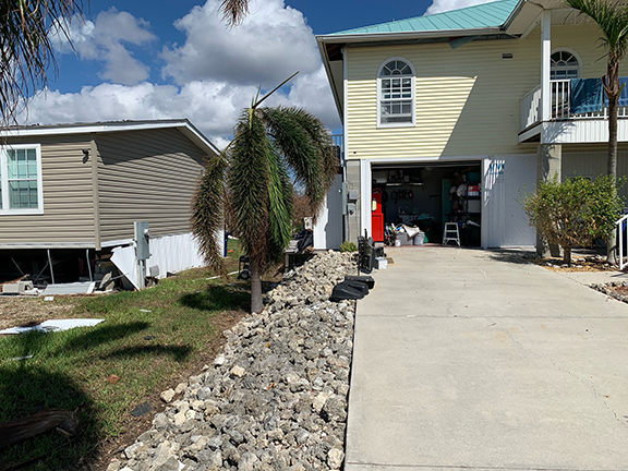
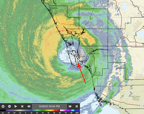
| JMII |
| (Weather Master) |
| Tue Oct 18 2022 09:58 AM |
| Attachment |
|
|
|
|
Quote:
Your roof is intact. I see no damage to the shingles.
You can't see it but the front half (south facing) roof shingles were ripped off.
All the downed trees I saw in Cape Coral were tipped over to the WSW telling me things were worse wind wise on the backside. This is what I experienced in Wilma too in NW Broward. I fully believe the eyewall winds were more inline with 120 MPH not 140-160 or some of the insane 180 "estimated" gusts some were claiming.
Arrow on the radar image is location of pictures above. Comparing this image against the localized damage I think the direct hit might have been a minor blessing since St James got the front and back of the eyewall with a period of calm in between. In contrast areas like Ft. Myers Beach were in the S eyewall the entire time, it never let up even after landfall. Downtown Ft. Myers flooded due to the ocean water pushing up the river where it getting funneled into a narrower space forcing it higher and higher. The radar also shows why the surge was bad down S in Naples, they too never saw a break from the onshore flow until Ian was halfway across the state. Everyone N of the eye experienced offshore flow and thus no surge at all.
| kapSt.Cloud |
| (Weather Hobbyist) |
| Tue Oct 18 2022 05:23 PM |
|
|
OMG! And I mean it as a prayer! I agree with you on the 120 mph winds. I seriously doubt your double-wide, or any home would still be intact with a Cat 4 storm. See the included video. A Cat 4 storm with a high storm surge would literally have flattened everything to ground level. Nothing but match sticks! People need to read about and look at the photos of what Katrina did to the three coastal counties of Mississippi.
Camille in 1969 was registering 175 mph until the instruments broke when she hit MS. Some have estimated at least 200 mph gusts. She cut a 2.5 mile gap in one of the barrier islands. Katrina widened it to a 3.5 gap. You are correct in stating it’s insane to estimate 180 mph winds. I’ve lived through enough of these storms starting with Donna in 1960 to know people have a tendency to embellish. They have no idea what a Cat 4 or 5 storm leaves behind…which is nothing!
https://www.theadvocate.com/baton_rouge/news/video_12a3653a-c1bb-5fdf-9b0b-d5f88f94a0b7.html
For those who didn’t evacuate and lived through Ian’s storm surge and for those who think a storm surge is just minor flooding you need to rethink your thoughts! And I ain’t whistling “Dixieâ€! Too bad for those who drowned didn’t listen to the warning to evacuate. The “cone†was at your back door. Then that jog to the east brought it to your whole house. For those who foolishly stay for the next one be certain to have an axe in the attic and pray your house stays intact long enough for you chop through to the roof. But, if it’s another Katrina…you’ve already lost due to a 30 to 32 foot storm surge! YOU CAN’T FIGHT WATER! YOU CAN’T FIGHT WATER!
https://www.bing.com/videos/search?q=Sto...26FORM%3DRESTAB
| kapSt.Cloud |
| (Weather Hobbyist) |
| Wed Oct 19 2022 12:03 AM |
|
|
You may have seen the following, but if not this should be of interest. Sad to say, for those who didn’t evacuate it was the beginning of the horror they witnessed before being washed away. They had time to be aware of the folly of their decision to not evacuate and realized there was no escape. A chill went down my spine while viewing it.
https://www.bing.com/videos/search?q=Hur...26form%3DVDMHRS
I recall reading about the 911 operator during Katrina sobbing because she couldn’t send help to those who were pleading for help. She had to listen to their cries, their screaming, then silence… except for the cacophony of Katrina’s fury. Why don’t people listen and pay heed to the warnings?
Another virtual video of storm surge:
https://www.bing.com/videos/search?q=Sto...26FORM%3DRESTAB
I post these links hoping people will listen to the warnings, take them seriously and evacuate when the next one hits. As he said a 3 foot storm surge is putting your life at risk.
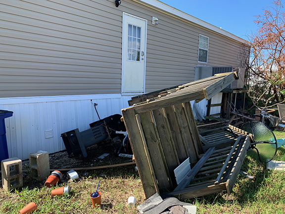
| Mike V |
| (Weather Watcher) |
| Sun Oct 23 2022 09:47 PM |
| Attachment |
|
|
I live in Cape Coral, but left to Homestead when I saw the storm headed in my direction. Once was enough with Andrew. My house is located on a direct access canal to the Caloosahatchee river. I got 6 1/2" of water in the house and I'm lucky compared to others. Here is a pic of how deep the water got.