CFHC
|
| () |
| Sun Aug 04 2002 12:08 PM |

|
|
|
Minor Update at 4PM:
Looks Like we have TD#2 in the gulf... more to come shortly.
Minor Update at Noon:
The Gulf System is looking bette now, but still too close to land to really leap forth. Aircraft Reconnaissance is heading out tomorrow to check on it.
Original Update:
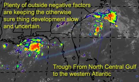
There is a trough of low pressure that's creating two interesting areas worth watching. One in the north central Gulf about due south of Mobile, Alabama, and another east of the carolinas. Both are driftng, and both could slowly develop.
Each system is in a fair local environment to develop quicker, but outside features (like an upper low near Texas) are keeping things in check. There is hardly any chance of either deepining quickly into anything dangerous, but still one of the two hotspots may have a chance. The one East of the Carolinas will tend to move south a bit, and then probably out to sea. If and when that happens it could get faily close to Florida, so it's worth an eye. By the time it does this conditions will be more favorible for development. The gulf system will cause rain somewhere, or at least enhancing the normal afternoon variety storms. This one has a better chance of development if it can hold out a bit longer and keep itself away from land.
 | ||
What's my opinion on the chances of the gulf one forming?
code:

forget it) 0 1 2 3 4 5 6 7 8 9 10 (sure thing)

          [--------*-------------]
Atlantic?
code:

forget it) 0 1 2 3 4 5 6 7 8 9 10 (sure thing)

          [--------*-------------]
Both could go either way at this point, we'll have to wait and see just a few more days.
NASA GHCC Interactive Satellite images at:
North Atlantic Visible (Daytime Only), Infrared, Water Vapor
Some forecast models:
NGM, AVN, MRF, ETA ECMWF
DoD Weather Models (NOGAPS, AVN, MRF)
AVN, ECMWF, GFDL, MM5, NOGAPS, UKMET
Other commentary at Mike Anderson's East Coast Triopical Weather Center, Accuweather's Joe Bastardi, Hurricane City, Gary Gray's Millennium Weather, Barometer Bob's Hurricane Hollow Even more on the links page.
- [mike@flhurricane.com]
| ShawnS |
| (Storm Tracker) |
| Sun Aug 04 2002 02:03 PM |
|
|
I'm still not convinced. I think it is too close to land now and is moving towards it. As with so many other ones lately this one waited too long to start cranking. I don't have any idea what is keeping these systems lately from forming but it is getting a little frustrating to sit and watch this happen time after time. One of these babies has to develop sooner or later..... it looks like now it will be later.
| Ricreig |
| (User) |
| Sun Aug 04 2002 02:39 PM |
|
|
|
|
In reply to:
but it is getting a little frustrating to sit and watch this happen time after time. One of these babies has to develop sooner or later.....
On an acedemic level, I have to agree it is frustrating, but in real life, I would not wish severe weather on our friends in the N Central Gulf (or anywhere for that matter). To give myself something to do instead of being frustrated that they are NOT developing is to try and figure out *why* they didn't and give thanks my mobile home isn't getting blown off the bricks it sets on...nor are any of my friends or neighbors.
I just remember that when these things *do* develop, they often cause many people more than just a little acedemic excitement.....I was in Biloxi when Camile came through, and that wasn't acedemic excitement at all, it was terror.
Yes, I am a devout weather enthusiast but never ever hope for the formation of severe weather to threaten me or others. .... however, if you want a storm for yourself, tell me where you live and I'll try and send a small F1 tornado your way
I will say that my good wishes aside, it does look like the N GOM is starting to develop rotation and some banding is evident, including what looks like a classic feeder band may coming in from the south.
It may not develop into a storm, but I'd surely take my umbrella if I lived in the Mibile area +- a hundred miles....
| Ricreig |
| (User) |
| Sun Aug 04 2002 02:51 PM |
|
|
|
|
Taking a look at http://www.wunderground.com/cgi-bin/satblast/satBlast?lat=30.741739&lon=-86.485451&width=450&height=225&zoom=2&SatType=VIS&Map.x=226&Map.y=149
I'd almost swear it HAD developed. You can see banding and a feeder forming.... Any surface data supporting this? Radar shows apparant rotation just out of range of what would appear to be a center of rotation. Stuff moving NW on the east side, and SW on the west side of the pics I'm seeing...
| mbfly |
| (Weather Guru) |
| Sun Aug 04 2002 03:00 PM |
|
|
|
|
I'm new here posting, but have depended on this site for a couple of years now for my hurricane info. I agree with you Ricreig, according to http://www.tropicalweatherwatchers.com/GOM.html
that system is rotating as far as I'm concerned ! I'm in Mobile and it's quite breezy here, the clouds have "that look" to them, and IMHO I think we're gonna get some yucky weather. I'll still leave it up to you experts though ! Thanks for a great site !!
| Ricreig |
| (User) |
| Sun Aug 04 2002 03:07 PM |
|
|
|
|
In reply to:
I'll still leave it up to you experts though !
Definitely NOT an expert here, but I've been looking up for a lot of years
It does have the earmarks of getting wound up a bit though....
| Unregistered User |
| (Unregistered) |
| Sun Aug 04 2002 04:15 PM |
|
|
This system is significantly healthier looking than yesterday, when I just about gave up hope on it. It has ample convection, and appears to be moving ever so slowly to the north. Yet the NHC does not believe it will develope. I don't try to diss them; they are the most reliable forcasters out there. However, it still could develope today. No one thought Allison would develope last year until it did.
| ShawnS |
| (Storm Tracker) |
| Sun Aug 04 2002 04:40 PM |
|
|
It doesn't have time to develop because it is too close to land already. It was forecasted to move west and instead is moving north.... like that was a big surprise. This one will be just a rainmaker for the north gulf coast and as usual we stay hot and dry here because of being on the west side of it. The system off the east coast will be nothing more than a fish spinner even if it does develop. I'm really starting to wonder about this season.
| Steve |
| (Senior Storm Chaser) |
| Sun Aug 04 2002 04:57 PM |

|
|
|
Don't give up yet Shawn. It feels like a depression here today, except we haven't gotten any rainfall. There are showers moving into lower St. Bernard and lower Plaquemines Parish right now. Maybe we'll get some of that action later this afternoon.
The system should turn west down the road. Bob Stokes on TWC just said it's already moving west. Steve Lyons said it would on the last TU. The blocking high to the north should steer it your way. The question is whether or not it's over land or just offshore once it turns. Technically, I think the low could still skirt off NE in front of the nose of another high down in the Gulf, but what do I know?
And finally, one of the segments of Atmospheres tonight deals with Alison. Maybe if you close your eyes really tight... Nevermind. Wait until Wednesday. If things work out, you'll be getting some tropical influence.
Steve
| Unregistered User |
| (Unregistered) |
| Sun Aug 04 2002 04:57 PM |
|
|
Don't count your chickens before they're hatched. This is forecast to just barely move inland and then slide West towards Houston.
| Unregistered User |
| (Unregistered) |
| Sun Aug 04 2002 05:08 PM |
|
|
check out buoy 42007
| Unregistered User |
| (Unregistered) |
| Sun Aug 04 2002 05:08 PM |
|
|
That post was from me.
| ShawnS |
| (Storm Tracker) |
| Sun Aug 04 2002 05:24 PM |
|
|
I've looked and looked and I don't see a westerly movement to it yet. If it were to start moving directly west NOW than it could possibly have a shot of some sort of development but it is suppose to continue on a NNW march first. I also thought I noticed the storms on the NE side of the system being blown off to the NE. Correct me if I'm wrong but that is not a positive sign for development, right? One more thing, why is the NHC waiting until tomorrow to possibly send a recon? It will certainly be too late then.
| Unregistered User |
| (Unregistered) |
| Sun Aug 04 2002 06:23 PM |
|
|
Definitely looks like a TD in the GOM. Drifting North; will it stall over water. LLC just off SC as well: stationary. But could be suppressed southward. Looks like it is slowly organizing per vis loops. Surprised NHC hasn't posted TDS on GOM system though. Interesting to see a power struggle develop. If GOM system shifts west it would lose influence on the other, and maybe two TDs. Cheers!!
| Unregistered User |
| (Unregistered) |
| Sun Aug 04 2002 06:39 PM |
|
|
BOUY DATA FROM THE ONE SOUTH OF DAUFIN ISLAND LOOKS INTERESTING. wIND IS PICKING UP AND PRESSURE IS DROPING.
| Unregistered User |
| (Unregistered) |
| Sun Aug 04 2002 06:39 PM |
|
|
All right everybody time to wake up. Things are starting to heat up a little.
DSAAT
SPECIAL TROPICAL DISTURBANCE STATEMENT
NATIONAL WEATHER SERVICE MIAMI FL
130 PM EDT SUN JUL 14 2002
SATELLITE AND RADAR OBSERVATIONS SHOW THAT A BROAD LOW PRESSURE AREA
IN THE NORTH CENTRAL GULF OF MEXICO HAS BECOME BETTER ORGANIZED.
COMPUTER MODEL GUIDANCE INDICATES THAT THE SYSTEM WILL DRIFT SLOWLY
WEST-NORTHWESTWARD WITHOUT SIGNIFICANT STRENGTHENING. HOWEVER THERE
IS SOME POTENTIAL FOR HEAVIER RAINFALL DURING THE NEXT FEW DAYS FROM
THE FLORIDA PANHANDLE WESTWARD THROUGH SOUTHERN LOUISIANA.
FORECASTER LAWRENCE
Also T#'s are out on the system. T1.5
| ShawnS |
| (Storm Tracker) |
| Sun Aug 04 2002 06:42 PM |
|
|
The NHC just put out a special dist. statement about the GOM system but only to say that it basically will not be classified because of being to close to land and it headed towards land. Wow, what a big surprise!! I guess this means they will cancel the recon that was suppose to fly out there tomorrow.
| Kevin |
| (Weather Master) |
| Sun Aug 04 2002 06:48 PM |

|
|
|
GOMEX: We have a TD here, folks. NHC isn't going to bother issuing advisories though because of it's proximity to land. It looks like the LLC is just on the ne side of the convection...haven't checked buoys at all but I'm sure there are some 25-30 knot winds and lower pressures. It's a rain event, that's all.
EC low: This one has gained convection today. This would could move south and spin up a rather significant cyclone near the Florida EC by mid-week. Two things need to happen for this to occur:
1. The upper trough loses it's influence on the low allowing the high to build south.
2. The GOMEX low moves west.
One of these things is happening already but the first one is the most important. The question is, when will it occur?
Kevin
| Unregistered User |
| (Unregistered) |
| Sun Aug 04 2002 06:49 PM |
|
|
TROPICAL WEATHER DISCUSSION
TROPICAL ANALYSIS AND FORECAST BRANCH
TROPICAL PREDICTION CENTER MIAMI FL
205 PM EDT SUN 04 AUG 2002
TROPICAL WEATHER DISCUSSION FOR NORTH AMERICA...CENTRAL
AMERICA...GULF OF MEXICO...CARIBBEAN SEA...AND ATLANTIC
OCEAN TO THE AFRICAN COAST FROM THE EQUATOR TO 32N INCLUDING
NORTHERN SECTIONS OF SOUTH AMERICA. THE FOLLOWING INFORMATION
IS BASED ON SATELLITE IMAGERY...WEATHER OBSERVATIONS...RADAR...
AND METEOROLOGICAL ANALYSIS.
Looks Like a Deppression already, but lets not ruin anyones weekend by having them to start watching this thing and report to work LOL. Weekends always seem to be slow for forecasting
| Unregistered User |
| (Unregistered) |
| Sun Aug 04 2002 06:52 PM |
|
|
Ooooops left out the import part LOL
A 1014 MB LOW E OF THE MOUTH OF THE MISSISSIPPI RIVER NEAR
28.5N88W AT 12 UTC IS BECOMING BETTER ORGANIZED AND COULD BECOME
A TROPICAL DEPRESSION LATER TODAY. SEE MIADSAAT FOR MORE
DETAILS. WIDELY SCATTERED TO SCATTERED MODERATE MOSTLY E OF THE
CENTER FROM 27.5N-31N BETWEEN 89W-84.5W.
| Unregistered User |
| (Unregistered) |
| Sun Aug 04 2002 07:06 PM |
|
|
low near the mississippi mouth should be classified later on. it has some chance of being a tropical storm.. very close to the coast. if you dont believe in storms intensifying as they move inland.. look at beryl from 1988. formed over lake ponchatrain.
low off the sc coast is stationary. most of the globals last night had it drifting up to near cape fear.. dont know what more recent ones are doing. really just have glanced at the some satelite pics.. going to check models and sfc obs.
HF 1648z04august
| WXMAN RICHIE |
| (Weather Master) |
| Sun Aug 04 2002 07:24 PM |

|
|
|
AREA FORECAST DISCUSSION
NATIONAL WEATHER SERVICE TALLAHASSEE FL
215 PM EDT SUN AUG 4 2002
CURRENT VISIBLE IMAGERY SHOWS TWO DISTINCT SURFACE LOWS...ONE OFF CHS AND ONE OFF MSY/MOB. THE GULF LOW SHOWS SOME ASPECTS OF A TROPICAL SIGNATURE...BUT SURFACE DATA ARE STILL BELOW TROPICAL-DEPRESSION LEVELS.
| Unregistered User |
| (Unregistered) |
| Sun Aug 04 2002 07:31 PM |
|
|
Yet another example of the NHC believing computer models instead of their own eyes.
| Kevin |
| (Weather Master) |
| Sun Aug 04 2002 07:36 PM |
|
|
|
|
The TLH discussion describes the situation pretty damn well. It says the low shows TC characteristics on radar and satellite imagery but surface obs show it is blw TD status. That should change soon. Still I'm only thinking that this will be a TD or a weak TS (30-35 knots at best). Could dump HUGE rainfall amounts though. Allison of 2001 proved rain can be worse than wind. We do have a potential windstorm off of the SC coast however....
Yes, above I was referring to 99L. It doesn't take a rocket scientist to see that there is a very broad area of low pressure off of SC...and the convection to the east is also trying to wrap around it's north side. The low is on land now but if a slow southward drift is beginning this could all change. Call me an idiot, but if the upper-trough continues to lose it's influence on these two lows we may just see a tropical storm 75-175 miles off of the Fla. EC by mid to late week. Time will tell if this in the cards.
I think the bottom line here is with all of the possible activity we've seen near the U.S. this year...it is a sign of increased U.S. activity for this season (especially EC, we've had two systems try to spin up near there this year, one in may). The ITCZ seems to be coming to life but needs to rise northward if anything is to spin up there.
| Kevin |
| (Weather Master) |
| Sun Aug 04 2002 07:45 PM |
|
|
|
|
http://kauai.nrlmry.navy.mil/tc-bin/tc_home
What was 98L is now 02L.noname
Kevin
| mbfly |
| (Weather Guru) |
| Sun Aug 04 2002 07:52 PM |
|
|
|
|
I know it's a dumb question, but WHY is TWC still saying "no tropical development" as I type ?? Sure looks like one to me !!
| Kevin |
| (Weather Master) |
| Sun Aug 04 2002 08:00 PM |
|
|
|
|
Need I say more? TD2 is official and it's also scary to think that weather buffs like us already know this is going on and TWC is totally clueless. Who updates their info? I'm pretty sure it's the infamous LISA MOSIER (lol)
Check out the satellite pick below from Accuweather. It shows 99L. It isn't quite developed yet, but this one's gonna blow up soon too!
http://hurricane.accuweather.com/adcbin/hurricane/satellite.asp?ocean=atlantic&thisreg=atln&type=&sattype=ir
The tropics have awaken it appears. Close to home, too.
| Unregistered User |
| (Unregistered) |
| Sun Aug 04 2002 08:21 PM |
|
|
See note on the ammended POD.
NOUS42 KNHC 041800 AMEND
WEATHER RECONNAISSANCE FLIGHTS
CARCAH, NATIONAL HURRICANE CENTER, MIAMI,FL.
0200 PM EDT SUN 04 AUG 2002
SUBJECT: THE TROPICAL CYCLONE PLAN OF THE DAY (TCPOD)
VALID 05/1100Z AUG TO 06/1100Z AUG 2002
TCPOD NUMBER.....02-074 AMENDMENT
I. ATLANTIC REQUIREMENTS
1. SUSPECT AREA IN GULF OF MEXICO
A. 05/1800Z
B. AFXXX 02BBA INVEST - CHANGED
C. 05/1700Z
D. 28.0N 89.0W
E. 05/1700 TO 06/0000Z
F. SFC TO 10,000 FT
2. OUTLOOK FOR SUCCEEDING DAY: BEGIN 6 HRLY FIXES AT 06/1200Z
IF THE SYSTEM DEVELOPS.
ADDED 3. NOTE: A RESOURCES PERMITTING INVEST WAS ADDED AT 04/1730Z
FOR 04/2100Z MISSON ID- 01BBA INVEST.
II. PACIFIC REQUIREMENTS
1. NEGATIVE RECONNAISSANCE REQUIREMENTS.
2. SUCCEEDING DAY OUTLOOK.....NEGATIVE.
| Unregistered User |
| (Unregistered) |
| Sun Aug 04 2002 08:31 PM |
|
|
http://www.srh.noaa.gov/radar/loop/DS.p20-r/si.kmob.shtml
Circulation center shows up pretty well around 29.0 and 88.8 or about 50 miles east of the mouth of the Mississippi and appears to be moving west slowly (hard to be sure because the radar loop is only about an hour.
New Orleans radar shows this also.
http://www.srh.noaa.gov/radar/loop/DS.p19r0/si.klix.shtml
If it is indeed moving west it might have a chance to develop a little more. We will see I guess. nice to have something to watch.
Hey Frank P and Steve where are ya. How about some local reports.
| ShawnS |
| (Storm Tracker) |
| Sun Aug 04 2002 08:53 PM |
|
|
I guess the NHC knows best but it sure looks like it has taken more of a westerly turn to me from the sat. pics I've been looking at. I also have been watching the radar loop out of New Orleans as you have houstontracker and see the same thing you do.Does anyone else have any thoughts on all of this?
| Steve |
| (Senior Storm Chaser) |
| Sun Aug 04 2002 08:54 PM |
|
|
|
|
NEW ORLEANS LA 27 X 1 X 28
Even though it's nothing, I always get excited when we hit the Proability Table. Ain't much to talk about on this end. We've got winds 15-20 gusting to about 25 in the area. There have been low clouds all day alternating wtih sunshine. We're on the decidedly dry side of TD #2. They are expecting heavy rain here between tonight and tomorrow. NWS is giving a 2-4" range. We've had several quasi-bands come through, but so far there hasn't been any rainfall - just the bands of clouds with the wind gusts. It's a super nice day. I'm going to work tomorrow, but it's time to run out and grab some brewskis for the evening!
WOO HOO!
Steve
| Unregistered User |
| (Unregistered) |
| Sun Aug 04 2002 08:59 PM |
|
|
In Metairie, by the lake, at about 2:00 we had some very squally weather, heavy rain, lasted about 20 minutes.
| Unregistered User |
| (Unregistered) |
| Sun Aug 04 2002 09:02 PM |
|
|
t.d. 2, nice. has probably 12-24hrs to remain over water. dont see why it cant get up to t.s. later in the week it should drift westward through louisiana to texas. probably going to be around for a few days.
99L is a bigger question. low not very organized.. deep convection mostly elsewhere. might get some baroclinic influence in a couple of days. dependent on how strong it is it will either be depressed south... or if it develops in the next couple of days it will probably be taken offshore. very weak systems are hard to predict.
area near bermuda still needs to be watched as well. though still not showing much of anything.
HF 2044z04august