CFHC
|
| () |
| Sat Aug 31 2002 05:30 PM |

|
|
|
Update at 5PM:
May have jumped the gun on the TD5 rumor. In any case, we could be looking at a TD later tonight or tomorrow.
Update at 4PM:
94L will be becoming Tropical Depression #5 at 5pm. More coming soon....
Original Update:
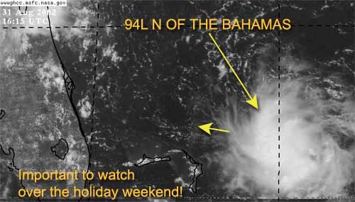
It is Labor Day weekend and the tropics are firing up.
The system (94L) just east-northeast of the northern Bahamas is looking more interesting by the hour. Since this system is so close the east coast of Florida it needs to be watched by all interests along our coast. This system very likely could be Tropical Depression #5 by the end of today.
There is a possibility that it could just die out (although I doubt it). The National Hurricane Center is sending recon out this afternoon to check it out.
In any case, it could bring a lot of rain to Florida for Labor Day. We are definitely keeping a close eye on this one.
Dolly seems to be holding its own at this time (barely) and it continues on its west northwest track. It has the potential of encountering some more heavy shear in the future and may dip below Tropical storm Strength for a while. However, I don't see it dissapating.
NRL Monterey Marine Meteorology Division Forecast Track of Active Systems (Good Forecast Track Graphic and Satellite Photos)
NASA GHCC Interactive Satellite images at:
North Atlantic Visible (Daytime Only), Infrared, Water Vapor
Some forecast models:
NGM, AVN, MRF, ETA ECMWF
DoD Weather Models (NOGAPS, AVN, MRF)
AVN, ECMWF, GFDL, MM5, NOGAPS, UKMET
Other commentary at Mike Anderson's East Coast Triopical Weather Center, Accuweather's Joe Bastardi, Hurricane City, Gary Gray's Millennium Weather, Barometer Bob's Hurricane Hollow, Snonut, Ed Dunham and Jason M in our Storm Forum Even more on the links page.
- [john@flhurricane.com]
| Unregistered User |
| (Unregistered) |
| Sat Aug 31 2002 06:00 PM |
|
|
The system off the east coast of florida is looking very intresting and believe we will have TD#5 possibly before the day is over. Recon is investigating this system this afternoon. People living in florida will won't to keep a close eye on this system this holiday weekend.
| Joe |
| (Storm Tracker) |
| Sat Aug 31 2002 06:01 PM |
|
|
Sorry last post was me.
| garyb |
| (Weather Guru) |
| Sat Aug 31 2002 06:02 PM |
|
|
http://www.nhc.noaa.gov/tafb/danger_atl_15.gif
| Steve |
| (Senior Storm Chaser) |
| Sat Aug 31 2002 06:23 PM |

|
|
|
Real quick - someone help me on this. Why are my odd number news page views scrolling off my cpu screen, yet the even ones (2,4) are the normal width? I checked settings but didn't see a screen adjustment.
Thanks,
94L is it? Looks a little impressive. There's a lot of energy to the south as well. Wonder if something could cook tomorrow evening?
Steve
| ROB H |
| (Weather Watcher) |
| Sat Aug 31 2002 06:32 PM |

|
|
|
Steve,
I am having the same problem
| Unregistered User |
| (Unregistered) |
| Sat Aug 31 2002 06:47 PM |
|
|
I think because of the size of the picture on the page, maybe?
| Colleen A. |
| (Moderator) |
| Sat Aug 31 2002 06:53 PM |

|
|
|
Steve & Rob....it isn't just you guys...I am also having the same problem. Could be just a glitch in the system.
You know....that system in the Bahamas sure looks at lot bigger on the satellite photo posted here...
And to cut Steve Lyons a little break, he is only reporting what the NHC is reporting. Which is that the system is moving WNW. They never really deviate from the official forecast, even if we can see it with our own eyes. Remember Irene? WE saw it moving towards S. Florida....the NHC, however, kept insisting it was heading towards the South Central Gulf Coast, and Miami suffered greatly because they would not correct the position. I am sure that once the Recon plane gets in there, they will have a better fix on it. Floridians: HEADS UP!
| Colleen A. |
| (Moderator) |
| Sat Aug 31 2002 06:54 PM |
|
|
|
|
No, it was doing it on the last news story also. I thought there was something wrong with my monitor..thank goodness there isn't. ;-)
|
MikeC
|
| (Admin) |
| Sat Aug 31 2002 07:03 PM |
|
|
I made a few adjustments, let me know if that fixed anything for you.
Hmm. Being on the coast this weekend (New Smyrna), I'm definitely eyeballing the storm the entire weekend, and since I have company too. Joy
| ROB H |
| (Weather Watcher) |
| Sat Aug 31 2002 07:10 PM |
|
|
|
|
Mike,
Thank you for the fix. It worked.
| ROB H |
| (Weather Watcher) |
| Sat Aug 31 2002 07:16 PM |
|
|
|
|
I read on another board that 2 recon plans are out at this
time. 1 in the gulf, 1 on its way to area east of fl.
| Colleen A. |
| (Moderator) |
| Sat Aug 31 2002 07:28 PM |
|
|
|
|
Mike or John: is the message in red that is scrolling across the screen re: 94L your message or an official message?
Looking at the satellite pics, this system to be wrapping itself up quite nicely...unless the center is to the south of that convection.
I also do not see any WNW movement whether the center is below the convection or is in the middle of the convection. It appears that it is moving due west. Dr. Steve Lyons can only report on the information he is getting from the NHC....I don't believe he can/will deviate from the official forecasts. Wouldn't be prudent.
I am very interested in finding out what Recon will report.
| Unregistered User |
| (Unregistered) |
| Sat Aug 31 2002 07:31 PM |
|
|
Area Forecats Discussion from TLH/MLB state that Bahama system should approch the MLB area Sundy night/Monday and any tropical ways approaching Fl shoud move west across Fl into the GOM.
|
MikeC
|
| (Admin) |
| Sat Aug 31 2002 07:33 PM |
|
|
Colleen, I changed it a bit to make it a little more obvious it came from us. I think its important over a holiday weekend to emphasize something like this even if it winds up missing or being minor. The mere fact that it reallty hasn't shown up on the radar until midday today (during the weekend) made me put that up. It's not an indication that anything will come of the system, but the fact many people are away for the weekend makes it more of an issue to get the word out to watch it.
|
MikeC
|
| (Admin) |
| Sat Aug 31 2002 07:37 PM |
|
|
HHunters found 50knot winds in one of the thunderstorms and a pressure of 1008mb. The wind clock may just be a gust, but I'm thinking TD or TS very very soon.
Edouard....
| Colleen A. |
| (Moderator) |
| Sat Aug 31 2002 07:41 PM |
|
|
|
|
Oh, ok Mike...no problem. I agree with you that it's important to make people aware of this system. Thanks for clarifying that, Mike. :-)
50 knts? Hmmm. We better keep our eyes peeled.
| Unregistered User |
| (Unregistered) |
| Sat Aug 31 2002 07:43 PM |
|
|
Mike any info on direction?? it is small but has a nice shape.
troy
| Jeanine |
| (Weather Watcher) |
| Sat Aug 31 2002 07:43 PM |

|
|
|
I just heard the same thing on TWC 50kt winds probably just in a thunderstorm?
| Unregistered User |
| (Unregistered) |
| Sat Aug 31 2002 07:48 PM |
|
|
how do i find the "Area Forecats Discussion from TLH/MLB " that Tony mentioned? any one have the link?
thanks troy
ps mike how do i get my login info if I lost it?
|
MikeC
|
| (Admin) |
| Sat Aug 31 2002 07:50 PM |
|
|
Troy you can put your email address in on the login screen and it should send you the password.
| Unregistered User |
| (Unregistered) |
| Sat Aug 31 2002 07:51 PM |
|
|
I foung the " Area Forecats Discussion from TLH/MLB " link..well same info just at another link troy
| Unregistered User |
| (Unregistered) |
| Sat Aug 31 2002 07:52 PM |
|
|
Troy heres the link to floridas nws discussions...
http://iwin.nws.noaa.gov/iwin/fl/discussion.html
| Joe |
| (Storm Tracker) |
| Sat Aug 31 2002 08:00 PM |
|
|
The bahamas system appears to have good outflow. Although latest ir sat loop shows thunderstorms decreasing there appears to be some building clouds again near center. With a reported pressure of 1008mb this could be are next TD before the days over with. Quick Scat winds show winds about 30 kts with this area.
| Joe |
| (Storm Tracker) |
| Sat Aug 31 2002 08:03 PM |
|
|
TD#5 AT 5PM!!!
|
MikeC
|
| (Admin) |
| Sat Aug 31 2002 08:07 PM |
|
|
Aye, the low in the Southeastern Bahamas may be another to deal with if TD#5 doesn't do much. We may be dealing with two systems in quick sucession on the East coast...
| Unregistered User |
| (Unregistered) |
| Sat Aug 31 2002 08:09 PM |
|
|
If the low near the bahamas (94L) is becoming a depression, than the east coast from florida to North Carolina MUST keep an eye out. While I doubt that it will become anything stronger than a tropical storm, it will make going to the beach along the Southeast coast require careful planning. I'm trying not to be a doomsayer; I'm just saying that especially this weekend, vacationers should be careful.
Whenever I think of labor day, I tend to remember people in Massachusets boarding up their houses in case of Hurricane Edouard. The hurricane ended up swinging to the east missing Long Island and Cape Cod, but now I will always connect Labor Day with hurricanes.
| Colleen A. |
| (Moderator) |
| Sat Aug 31 2002 08:11 PM |
|
|
|
|
Joe....have they posted any information on TD#5 such as windspeed, direction etc? Or just that it's formed? Wow. That was fast.
| Colleen A. |
| (Moderator) |
| Sat Aug 31 2002 08:15 PM |
|
|
|
|
Good points about beach safety. I noticed on the NRL Monterey Page that they took down the coordinates off the visibles in just the last few minutes. It was 28.0N/74.0W.
Well, this should prove to be an interesting weekend...and don't forget, this storm (if it continues westward) will be crossing the Gulfstream, which could cause a rapid intensification to happen.
| WXMAN RICHIE |
| (Weather Master) |
| Sat Aug 31 2002 08:17 PM |

|
|
|
Outflow of storm looks great. Convection on the wane. Let's see overnight if the convection really blossoms or the warmer water in front of it helps it blossom.
| WXMAN RICHIE |
| (Weather Master) |
| Sat Aug 31 2002 08:23 PM |
|
|
|
|
If it is at 28N 74 W, that would be 430 miles due east of Melbourne.
| Kevin |
| (Weather Master) |
| Sat Aug 31 2002 08:39 PM |

|
|
|
Everyone along the U.S. East Coast, especially Florida, MUST keep a very close eye on TD 5 tomorrow. Normally this woudln't be a big thing...but with many nutcases on the roads (drunks included), we could be in for a rough Labor Day Weekend. I'm not so sure about wind speed yet...model guidence should tell us a little more tongiht when the runs come out. Winds could get as high as 70-85 mph. I know that this may be overdoing it, but the depression is going to go over the Gulf Stream. The upper-level conditions look ideal, too. We may just get a surprise out of this one. My first forecast will be around 10-midnight as I am headed out to a theme park (good to get that done now
Kevin
| Colleen A. |
| (Moderator) |
| Sat Aug 31 2002 08:40 PM |
|
|
|
|
Yes, that is now back up on the visible picture from the NRL page. However, I do not know if that is just a guesstimate or the actual center. I have not received an update from the NHC about TD#5...was this an error?
| Colleen A. |
| (Moderator) |
| Sat Aug 31 2002 08:45 PM |
|
|
|
|
And just to keep us on our toes....Dolly is now heading west at 20knts. No change in strength.
| SirCane |
| (Storm Tracker) |
| Sat Aug 31 2002 09:02 PM |

|
|
|
What do you all think? I remember Erin forming around this area.
|
MikeC
|
| (Admin) |
| Sat Aug 31 2002 09:17 PM |
|
|
Not TD#5, it was looking as if it might, but the later scans by the HH aircraft made it just under TD strength. We'll be watching it though. TD Tonight or Tomorrow.
It is Moving WNW around 10MPH
| Joe |
| (Storm Tracker) |
| Sat Aug 31 2002 09:27 PM |
|
|
Well NHC decidied to hold off on TD#5 for now. But maybe made late tonight or tomorrow.
| Colleen A. |
| (Moderator) |
| Sat Aug 31 2002 09:32 PM |
|
|
|
|
You know, that's very strange because the HH found SUSTAINED winds of 60mph and low pressure (this was all reported by TWC) but when they went back in again, the pressures were up. I guess they are waiting to see if it holds together before jumping the gun. I think that's a good idea.
However, I still think it will be classified later on tonight.
| Unregistered User |
| (Unregistered) |
| Sat Aug 31 2002 09:39 PM |
|
|
look in sotheast bahamas strong storms forming there. and off africa have large storm coming off, already has banding and good outflow.
| Kevin |
| (Weather Master) |
| Sat Aug 31 2002 09:50 PM |
|
|
|
|
TWC was reporting winds of 60 (gusts) and 1008 mb pressure, BUT this was the last vortex data message from CHRISTOBAL! Ooops...typical TWC stupidity.
Also...the 5:30 PM TWO says 94L disturbance is moving northwest...but I've watched the satellite imagery from the past few hours. The loop showed a west-northwest movement, if any at all. A very slow moving due to weak steering currents. I still believe it will be depression...and I still believe Florida is the bull's eye.
Also, Dolly is flying west again, but this was not supposed to happen. If this height breakdown isn't as strong as models predicted, with Dolly being so weak, well...
Any thoughts on 94L's movement now and into the future?
Kevin
| Unregistered User |
| (Unregistered) |
| Sat Aug 31 2002 10:19 PM |
|
|
Speaking of stupidity..............never mind.............
| Unregistered User |
| (Unregistered) |
| Sat Aug 31 2002 11:29 PM |
|
|
though only slightly, it does appear that the convection may be back on track for the new system yet to be.
http://wwwghcc.msfc.nasa.gov/GOES/goes8hurrir.html.
-check the 4 previous images to see what i mean-
troy
| Unregistered User |
| (Unregistered) |
| Sat Aug 31 2002 11:31 PM |
|
|
http://wwwghcc.msfc.nasa.gov/GOES/goes8hurrir.html
dont know how that period got in at the end of that link
| Unregistered User |
| (Unregistered) |
| Sat Aug 31 2002 11:37 PM |
|
|
94L has been edging westward for days, but is about to brickwall against the upper feature over the southeast. steering currents are going to get really week.. any time this happens its safest to bet on the system eventually going north. probably get to within a hundred miles of the florida east coast and then start moving up toward the carolinas. in the weak steering environment and over waters 28-29C, do expect this storm to intensity fairly quickly once it gets going.
dolly is essentially unchanged, moving wnw, firing convection in bursts. expect it to miss NE of the islands, maybe weaken into the open wave as some are suggesting. pretty uncertain how dolly will end up, but i dont see a neat recurvature.. it either dies or gets by the shear and keeps coming.
several globals want to put something in the gulf in a few days.. not that pissant swirl off brownsville.
new emerging wave is well defined, still expect an invest out of it within a day or two.
may be a low pressure area forming off NC coast.. might bring 94L north to it, or develop into a system itself.
upper TUTT low SE of bermuda.. some models hint at it developing a sfc feature. will see.
HF 2335z31august
| Colleen A. |
| (Moderator) |
| Sun Sep 01 2002 12:50 AM |
|
|
|
|
LOL.....I just watched Mike Sidell on the WC, and he was so flustered that he could hardly talk. Poor guy...he probably got reamed by the NHC.
Convection is looking better with 94L; still looks like it's moving in a general westward motion. Both NWS discussions from Jax/Melbourne talked about this feature earlier this afternoon, don't know what their current thinking is on this one as of now.
Anyway...it's been interesting, that's for sure.
| Unregistered User |
| (Unregistered) |
| Sun Sep 01 2002 12:57 AM |
|
|
it was probably some intern working the labor day holliday that pulled up the wrong info...
As for 94L check this link to see what Collen and I have seen
http://wwwghcc.msfc.nasa.gov/GOES/goes8hurrir.html
check the oldest image(around 6pm) then compare to current. Definate increase in convection
Troy
| Bruce |
| (Weather Guru) |
| Sun Sep 01 2002 01:09 AM |
|
|
94L can be seen on Melbourne's long range radar loop.
| Unregistered User |
| (Unregistered) |
| Sun Sep 01 2002 01:21 AM |
|
|
bust out the link Bruce!!
Im lazy!
troy
| Frank P |
| (Veteran Storm Chaser) |
| Sun Sep 01 2002 01:21 AM |
|
|
Hey Colleen - I agree with you on the movement. Reviewing the latest IR loop, and sometimes the IR loops can be somewhat deceiving, 94L is moving more west than anything else IMO (at least during the past several hours). You guys are right on this one because it could crank up quickly as it approaches the gulf stream. No real significant buoy data on the system yet..
Some strong convection all day also in the southern GOM but looks to be dying off a little tonight, movement appears to be towards the NW and IF it holds together could bring some rain to the northern gulf coast on Monday.
It's early September, the peak of the Hurricane Season, and just like the baseball players.... our little tropical systems have decided not to go on strike either...... stay tuned..
| Unregistered User |
| (Unregistered) |
| Sun Sep 01 2002 01:25 AM |
|
|
http://www.srh.noaa.gov/radar/latest/DS.p20-r/si.kmlb.shtml
radar Bruce mentioned
i checked the outer bouy at 120miles..pressure there are steady if nout up a tiny bit!? but that really isnt all that close yet to the small 94l.
The swells and seas are holding if not increasing so that may be a sign.
troy
| Bruce |
| (Weather Guru) |
| Sun Sep 01 2002 01:29 AM |
|
|
Check out Dolly? Seems to have two centers? One going North the other West. Input Please. Thanks.
| Frank P |
| (Veteran Storm Chaser) |
| Sun Sep 01 2002 01:38 AM |
|
|
Good radar loop guys.
Radar confirms the general west movement... looks to be due west at the moment... convection holding steady north of the center... radar not seeing the eastern quadrant yet...... small compact little system at the moment... very interesting to say the least...
| Unregistered User |
| (Unregistered) |
| Sun Sep 01 2002 01:55 AM |
|
|
Speaking of said radar loop. Doesnt it seem to be moving W kinda fast? http://www.srh.noaa.gov/radar/latest/DS.p20-r/si.kmlb.shtml
loop i saw ran from 8:35pm through 9:40pm may be a rainy Sunday morning if the trend on radar continues...
Troy
| Unregistered User |
| (Unregistered) |
| Sun Sep 01 2002 02:23 AM |
|
|
Once again this year Colleen knows more than the NHC. Sorry Colleen, I don't mean to offend you but what are your real credentials here?
| BillD |
| (User) |
| Sun Sep 01 2002 02:59 AM |
|
|
Colleen is a long time member here, and although not everyone agrees with everything she has to say, we respect her opinions.
I object to you asking her to defend her "credentials". Who do you think you are, hiding behind anonymous access? We are not all experts here, and don't claim to be.
The NHC does not always do a stellar job (noone is perfect, and this is an imperfect science to start with) and there are times their forecasts are based more on politics and the fear of causing panic, than on reality. Its too bad the past years of posts got lost, because if you went back several years you would see this is a common issue throughout. We all get frustrated with the NHC at times.
We welcome your opinions, but we don't welcome bashing others for theirs.
Bill
| StormHound |
| (Weather Guru) |
| Sun Sep 01 2002 03:08 AM |
|
|
Here, here, Bill!
There are very few professionals on these boards. We're here to share opinions, most of which are wrong. Sometimes we're right and get to pat ourselves on the back. Mostly, we're here just to learn. Go bash someone on another board, we don't do that here.
Good to see you again, Colleen! I haven't been around much this year. I hope to be hanging around more the next several weeks. Things are starting to get interesting.
| MelbDave |
| (Registered User) |
| Sun Sep 01 2002 03:10 AM |
|
|
Thanks Bill.. We all like Colleen
| Unregistered User |
| (Unregistered) |
| Sun Sep 01 2002 03:15 AM |
|
|
Plus if there was ever a dues quota here Coleen has more than fufilled that quota. From the few years i have been coming here she has allways been more than eager to learn.
Plus, I dont really remeber her ( at least in this thread
anyway..the latest discussion still mentions the chance of 94L becomng an official entity or storm or TD.
Coleen Good- anonymous anticoleen poster Bad
Troy
| Joe |
| (Storm Tracker) |
| Sun Sep 01 2002 03:19 AM |
|
|
Well NHC is holding off on TD advisory. Dolly getting ripped by shear and short term doesn't look good. Also impressive wave moving off africa. Note: this is a place where people come to give their opinions. We are not perfect!
| Mitch |
| (Verified CFHC User) |
| Sun Sep 01 2002 03:26 AM |
|
|
Funny, local channel 6 from Orlando just said the low east of FL will be heading North towards the Carolinas. I would think they would be giving a message saying "keep watch" just in case. It still looks to moving westward.
| garyb |
| (Weather Guru) |
| Sun Sep 01 2002 03:33 AM |
|
|
Colleen
--------------------------------------------------------------------------------
Who is Colleen?
I am a graduate student at Colorado State University in Fort Collins, Colorado. My advisor is Dr. Bill Gray, hurricane scientist and world-renowned tropical guru. I'm also a meteorological consultant to CFHC& . In the summers I work at the National Hurricane Center in Miami, Florida.
Besides being a major tropical weather enthusiast, I enjoy tennis, volleyball, and listening to 80s music..
--------------------------------------------------------------------------------
| troy2 |
| (Storm Tracker) |
| Sun Sep 01 2002 03:36 AM |
|
|
makes ya wonder if the local news; Central Florida here, gets pressure from different local Chamber of Commerce b/c of the big $ making weekend. kind of like dont tell em till ya have to.
anyway convection still looking good on 94L
found my login info
| 57497479 |
| (Weather Master) |
| Sun Sep 01 2002 03:40 AM |

|
|
|
I am fairly new to this forum, but one thing that I have learned in a short period of time is that our CREDENTIALS on this site is our opinions. Heck, I could have been bashed a long time ago
Thanks Colleen for all of your opinions!!! (Pinwheel) Toni
| damnedcat |
| (Registered User) |
| Sun Sep 01 2002 04:00 AM |
|
|
A weather newbie here. Can anyone tell me what, if anything, is steering 94L?
| 57497479 |
| (Weather Master) |
| Sun Sep 01 2002 04:19 AM |
|
|
|
|
YEA, REMEMBER THE MOVIE JAWS!!
PINWHEEL TONI
| Steve |
| (Senior Storm Chaser) |
| Sun Sep 01 2002 06:09 AM |
|
|
|
|
That's all well and good because I respect what you post. But I don't recall her message directed at all to you. And what Colleen posted today was hardly out of line. She served up a generous, and well earned if I don't mind saying so myself, silce of humble pie.
Steve
| Rich B |
| (British Meteorologist) |
| Sun Sep 01 2002 08:21 AM |
|
|
In defense of Collen, i know we have not always seen eye to eye, but her posts are always good, and she does know what she is on about! I would hate to see her no longer posting cause of some disagreement!
| Cycloneye |
| (Storm Tracker) |
| Sun Sep 01 2002 11:35 AM |
|
|
The african wave that has emerged africa has a 1011 mb at 13n and plenty of convection.Now let's wait and see if this wave will make it all the way into the atlantic behind Dolly that is being sheared apart.
| Unregistered User |
| (Unregistered) |
| Sun Sep 01 2002 11:43 AM |
|
|
disturbance near bahamas could rapidly stremgthen looks better and better. wave off africa will also become storm in a few days.
| WXMAN RICHIE |
| (Weather Master) |
| Sun Sep 01 2002 11:47 AM |
|
|
|
|
Looks like the storm will crank up today. No shear, convection building and becoming symetrical, warm gulfstream water ahead. Melbourne overnight discussion even mentions threat of rapid intensification possible close to shore on a holiday weekend. STAY AWAKE!!!!
| Unregistered User |
| (Unregistered) |
| Sun Sep 01 2002 11:59 AM |
|
|
it could already be a tropical storm. and when it hits gulfsteam look out. rapid strengthning.
| k___g |
| (Weather Guru) |
| Sun Sep 01 2002 12:05 PM |

|
|
|
looks pretty healthy.....the bouys in the area indicate dropping pressures..........
| Jeanine |
| (Weather Watcher) |
| Sun Sep 01 2002 12:29 PM |
|
|
|
|
8:05 TROPICAL WEATHER DISCUSSION: A 1014 MB LOW IS NEAR 29N77W MOVING NW 10 KT. SATELLITE IMAGES
SUGGEST THAT THE AREA IS GETTING BETTER ORGANIZED AND
RECONNAISSANCE WILL INVESTIGATE LATER THIS MORNING. A CLUSTER
OF MODERATE TO STRONG CONVECTION IS WITHIN 90 NM OF 29.5N76W.
WIDELY SCATTERED SHOWERS OVER THE NW BAHAMAS.
JUST CHECKED ALL EAST COAST BOUYS AND NONE OF THEM AT THIS TIME SHOW PRESSURE DROPPING, ALL WERE EITHER RISING OR STEADY
| troy2 |
| (Storm Tracker) |
| Sun Sep 01 2002 12:43 PM |
|
|
It seems more like its just growing in area covered than actually moving NW at 10kt. Melbourne long range radar
http://www.srh.noaa.gov/radar/latest/DS.p20-r/si.kmlb.shtml
is picking it up nicely now.
| Jeanine |
| (Weather Watcher) |
| Sun Sep 01 2002 12:44 PM |
|
|
|
|
JUST THOUGHT THIS MAKES FOR SOME INTERESTING READING:
http://www.srh.noaa.gov/data/MIA/AFD/MIAAFDMLB.1.txt
| tom5r |
| (Weather Watcher) |
| Sun Sep 01 2002 12:44 PM |
|
|
After seeing TWC loop I have to agree on the more northerly movement as this system approaches land. I'm gonna go with the Carolinas if it touches land at all. I suppose there is that chance of it sitting off the coast and lurking about for a few days as that seems to be the history with this particular area. Guess we have to wait and see.
Tom
| Unregistered User |
| (Unregistered) |
| Sun Sep 01 2002 12:52 PM |
|
|
SPECIAL TROPICAL DISTURBANCE STATEMENT
NATIONAL WEATHER SERVICE MIAMI FL
815 AM EDT SUN SEP 1 2002
SATELLITE...RADAR...AND SURFACE OBSERVATIONS INDICATE THAT THE
TROPICAL DISTURBANCE LOCATED ABOUT 150 MILES DUE EAST OF CAPE
CANAVERAL FLORIDA HAS BECOME MUCH BETTER ORGANIZED THIS MORNING...
AND A TROPICAL DEPRESSION OR A TROPICAL STORM MAY BE FORMING. THE
SYSTEM IS MOVING SLOWLY WESTWARD AT 7 MPH...BUT A GRADUAL TURN TO
THE WEST-NORTHWEST IS EXPECTED TO OCCUR LATER TODAY.
AN AIR FORCE RESERVE RECONNAISSANCE AIRCRAFT IS ENROUTE TO
INVESTIGATE THE SYSTEM AND SHOULD PROVIDE A BETTER ESTIMATE OF THE
INTENSITY BY ABOUT 11 AM EDT. HOWEVER...ALL INTERESTS ALONG THE
FLORIDA EAST COAST SHOULD CLOSELY MONITOR THE PROGRESS OF THIS
SYSTEM TODAY IN THE EVENT ANY WATCHES OR WARNINGS BECOME NECESSARY.
FORECASTER STEWART
| Colleen A. |
| (Moderator) |
| Sun Sep 01 2002 01:01 PM |
|
|
|
|
My. A lot of fussing going on here about me, and I didn't even know about it.
To the Anonymous poster: I do NOT know more than the NHC. I do, however, have 20/20 vision and I can see well. That "broad area of low pressure" that TWC screwed up yesterday is not moving NW, it's moving WEST. All you have to do is look at the horizontal lines to SEE this. However, the NHC is going with models that are, quite literally, all over the place and have absolutely no credibility...some send it north, then east then back south again. As a matter of fact, most of them do. TWC is a mouthpiece for the NHC, and they will say what the NHC wants them to say....to do anything different would not be kosher. Do you remember Irene? TWC had Jim Cantore in Miami and Mike Sidel in Sarasota and who was getting pounded? MIAMI. They put a LOT of people in danger because schools were not closed, workers were not allowed to go home, etc. People were in their cars driving while the winds were howling in Miami and the NHC still had the system headed towards Sarasota. That was a huge blunder, and it was stupid. You can take all the models in the world and put them to work, but if you cannot use your own eyes and your gut instincts, you're in trouble. I don't have any degrees or fancy plaques with my name on them, but there are two things I WILL do: I will admit when I am wrong, and I will tell you exactly why I am thinking the way I am. I However, if I am RIGHT, I will never say, "I told you so," or "Look how good I am" or "I've been predicting this since the beginning of time." blah blah blah.
To the rest of you who defended me while I was completely unaware of this, LOL: thank you all....Steve, Gary B. was just joking, we have been friends for quite some time. He meant no offense, and I didn't take any.
Now, I still see this thing moving towards the west, even though Steve Lyons is saying NW, we'll see what happens. He's not even telling Florida residents to be on the lookout; he's saying the Carolina's. We shall see.
| Colleen A. |
| (Moderator) |
| Sun Sep 01 2002 01:08 PM |
|
|
|
|
You're right...the thing that worries me the most is that is will be crossing the gulfstream. And if local mets are not mentioning even a hint of a *possible* landfall, and TWC is saying NW and Carolinas..what happens *if* they are wrong?
I think they will classify it at 11. Then again, I thought that last night, too. *grins*
| Colleen A. |
| (Moderator) |
| Sun Sep 01 2002 01:13 PM |
|
|
|
|
Whoops! I spoke too soon....glad to see they mentioned Florida in there. Now the question is, is the system going to turn WNW or just keep going west? They've been saying NW for the last day....when it was going west.
Is it possible that this area is getting too close to land to intensify to a strong storm? Or are we (if it heads our way) going to be looking at just a strong TS? I really don't know what will happen if/when it crosses the GS.
| Maxx |
| (Registered User) |
| Sun Sep 01 2002 01:13 PM |
|
|
looking at the Melbourne radar on the long range loop, the storm does not seem to be moving too fast and if anything looks to be moving west not nw
| Unregistered User |
| (Unregistered) |
| Sun Sep 01 2002 01:16 PM |
|
|
colleen welcome back, dont you miss john hope, i just saw lyons too, i hardly watch him anymore he rushes thru everything. and that thing is not moving n,w, no way. just use your eyes not a computer. i couldnt believe he didnt even mention fla. either. he is not always being fed that from nhc, he says things on his own. and he didnt mention the obvious the gulf stream temp. i think this thing could skip depession stage and become t.s. and mentioned trof that will catch it, its goin by it wont influence it. mark
| troy2 |
| (Storm Tracker) |
| Sun Sep 01 2002 01:21 PM |
|
|
looking at todays 06 run of the gdfl it does show what would be Eduordo moving north eventually at 48 hours at about Little River around the border of N and S Carolinia (33.6n 78.6w) with about cat 1 strenghth then puts him inland for about 8 hours then it kinda moves him south to about the GA SC border just offsore at 96 hours and inland at about 31.8n 81.3w at 102 hours... just noticed the uniqueness in the model path is all...
| troy2 |
| (Storm Tracker) |
| Sun Sep 01 2002 01:28 PM |
|
|
Coleen
While it may not strenghten into a monster, it has, as we saw overnight strengthend some. NHC mentioned favorable conditions to stregthen;light shear, highp aloft at 500mb.
I think it can and will strenghten. "Where's ole Eddie goin?" is the question
| Bruce |
| (Weather Guru) |
| Sun Sep 01 2002 01:33 PM |
|
|
Here in Palm Bay one word HOT HOT HOT. Was hot all night long. If this storm does come around our area, FLOOD FLOOD FLOOD, due to the slow movement and the saturated ground here.
| Colleen A. |
| (Moderator) |
| Sun Sep 01 2002 01:58 PM |
|
|
|
|
I agree Mark..I think if you are a tropical wx "expert", you should be able to deviate from what they say is happening and just say what you see is happening. I think, after just looking at the Weekend Update, that they are (maybe) basing the track of whatever this storm is at 11 on climatology, because the "usual" tracks in September WOULD take it into the Carolinas. They have been saying NW for at least 36 hours now, and they were wrong. It even says "west" in the STD statement. But we know that nothing is a sure bet in weather, and I would be very hesitant to base my predictions on "climatology". They may very well be right, but being that they are THE Weather Channel, they need to be more responsible in their reporting.
I remember a storm that was suppossed to make that "climatogically" favored turn to the WNW. It didn't. It went west, and no one was ready and had 1 day to prepare for it as it crossed the gulfstream.
His name was Andrew.
| Colleen A. |
| (Moderator) |
| Sun Sep 01 2002 02:01 PM |
|
|
|
|
I bet at 11am we will have a very strong TD or Eduardo. I don't blame them for waiting for recon to go in again before classifying it, as they wanted to be sure. But the statement "all residents along the Florida East Coast" is completely different than what we have been told in the last 36 hours.
| Bruce |
| (Weather Guru) |
| Sun Sep 01 2002 02:13 PM |
|
|
Hey Colleen, Sure does look good on all loops. You have had alot of rain in your area this month. Look like were in for more. This storm sure seems to be making it way to us. I remember only one weather person in South Florida saying Andrew was going to go right into South Florida, all others said a curve to the North. Take Care
| Joe |
| (Storm Tracker) |
| Sun Sep 01 2002 02:29 PM |
|
|
Wow, looks like we will have a TS before long. With the warm gulf stream waters this is exploding. Still believe this will continue to move west. This should make for one intresting labor day!
| ShawnS |
| (Storm Tracker) |
| Sun Sep 01 2002 02:39 PM |
|
|
Colleen,you are right. I think we are both in agreement that the NHC will only go by what the models say. If the models are all over the place than they will pick whatever is in the middle and go with that.The problem with the models is that most of them what to go the easy route. If there is a trough in site than they will ALWAYS say that the trough will come and pick a storm up and take it out.They never even act like there is a possibility that this won't happen. And if they don't than neither will the NHC. All of us on this site know better than to trust models,though. That is why sometimes we seem to look smarter than the people at the WC and the NHC. I'm with you, Colleen.
ShawnS
| Joe |
| (Storm Tracker) |
| Sun Sep 01 2002 02:46 PM |
|
|
I do not see this turning NW per steering winds. This will likely be a threat the FL. Clearly you can see a slow west movement.
|
CFHC
|
| () |
| Sun Sep 01 2002 02:50 PM |
|
|
|
|
AFDMLB
EAST CENTRAL FLORIDA FORECAST DISCUSSION
NATIONAL WEATHER SERVICE MELBOURNE FL
1040 AM EDT SUN SEP 1 2002
...A TROPICAL CYCLONE DEVELOPING JUST EAST OF FLORIDA...
RECONAISSANCE AIRCRAFT WITHIN THE SYSTEM JUST EAST OF FLORIDA ATTM
AND FORTHCOMING INFORMATION FROM NHC WILL BE USED IN MARINE AND ZONE
UPDATES. SHOULD A TROPICAL STORM WATCH BE ISSUED REFER TO THE
HURRICANE LOCAL STATEMENT AND THE ASSOCIATED GRAPHICAL HURRICANE
LOCAL STATEMENT ISSUED BY NWS MELBOURNE FOR INFORMATION SPECIFIC TO
PERSONS IN EAST CENTRAL FLORIDA.
MARINE...THE FORECAST UPDATE WILL INCLUDE EXPECTED EFFECTS OF THE
TROPICAL SYSTEM AS IT MOVES THROUGH THE COASTAL WATERS DURING THE
NEXT 24 TO 36 HOURS.
.MLB...NONE.
PUBLIC/MARINE...PENDERGRAST
AVIATION/FIRE WX...LASCODY
| Hurric |
| (Weather Guru) |
| Sun Sep 01 2002 02:57 PM |

|
|
|
We are all going to just have to be patient for a little longer and they will tell us if or where they find a LLC.
It's obvious rains are getting closer to the coast which makes it look like it's moving west. I can't make out a center from Sat pics, but overall area sure does appear to be moving west.
Nice to have something to watch on Labor Day weekend.
David '79 was a Labor Day storm.
Hurric
| Steve |
| (Senior Storm Chaser) |
| Sun Sep 01 2002 03:40 PM |
|
|
|
|
A RECONNAISSANCE AIRCRAFT IS CURRENTLY INVESTIGATING A VIGOROUS
TROPICAL DISTURBANCE LOCATED ABOUT 150 MILES EAST OF CAPE CANAVERAL
FLORIDA. RECENT REPORTS FROM THE AIRCRAFT...ALONG WITH SATELLITE
AND RADAR IMAGERY...SUGGEST THAT A TROPICAL DEPRESSION MAY BE
FORMING EVEN THOUGH THE SURFACE PRESSURE IS RELATIVELY HIGH. THIS
SYSTEM IS MOVING TOWARD THE WEST OR WEST-NORTHWEST AT ABOUT 5 TO 10
MPH. INTERESTS ALONG THE GEORGIA AND FLORIDA EAST COASTS SHOULD
CLOSELY MONITOR THE PROGRESS OF THIS SYSTEM IN CASE ANY WATCHES OR
WARNINGS ARE REQUIRED LATER TODAY.