CFHC
|
| () |
| Sun Sep 01 2002 03:22 PM |

|
|
|
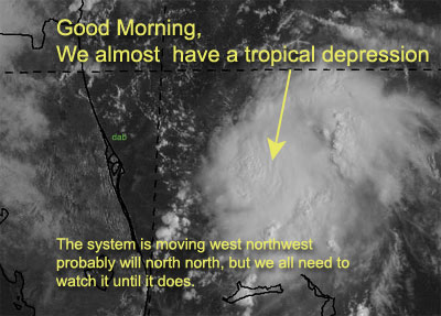
Aircraft Recon is out, at the storm is on the verge of becoming a depression. I would not be surprised later to see tropical storm watches up for our coast fairly soon...
It is 150 miles East of Cape Canaveral right now.
Enjoy the weekend, but continue to check up on this system... Florida and Georiga especially.
Melbourne Radar - Long Range
Dolly still is moving wwn, and barely holding onto tropical storm strenght. I believe it'll pass well north of the caribbean. The Northeast gulf is too disorganized, and western Caribbean isn't looking well.
NRL Monterey Marine Meteorology Division Forecast Track of Active Systems (Good Forecast Track Graphic and Satellite Photos)
NASA GHCC Interactive Satellite images at:
North Atlantic Visible (Daytime Only), Infrared, Water Vapor
Some forecast models:
NGM, AVN, MRF, ETA ECMWF
DoD Weather Models (NOGAPS, AVN, MRF)
AVN, ECMWF, GFDL, MM5, NOGAPS, UKMET
Other commentary at Mike Anderson's East Coast Triopical Weather Center, Accuweather's Joe Bastardi, Hurricane City, Gary Gray's Millennium Weather, Barometer Bob's Hurricane Hollow, Snonut, Ed Dunham and Jason M in our Storm Forum Even more on the links page.
- [mike@flhurricane.com]
| garyb |
| (Weather Guru) |
| Sun Sep 01 2002 03:29 PM |
|
|
DISCLAIMER...NUMERICAL MODELS ARE SUBJECT TO LARGE ERRORS.
PLEASE REFER TO TPC/NHC OFFICIAL FORECASTS FOR TROPICAL CYCLONES.
.....THE FOLLOWING IS A TEST MESSAGE.....
TROPICAL DEPRESSION INVEST (AL942002) ON 20020901 1200 UTC
...00 HRS... ...12 HRS... ...24 HRS...
020901 1200 020902 0000 020902 1200
LAT LON LAT LON LAT LON
BAMD 28.5N 78.1W 29.1N 79.4W 29.6N 80.1W
BAMM 28.5N 78.1W 29.3N 79.7W 29.9N 80.8W
A98E 28.5N 78.1W 28.5N 79.3W 28.9N 79.7W
LBAR 28.5N 78.1W 29.0N 79.5W 29.5N 80.7W
SHIP 25KTS 30KTS 39KTS
DSHP 25KTS 30KTS 39KTS
...36 HRS... ...48 HRS... ...72 HRS...
020903 0000 020903 1200 020904 1200
LAT LON LAT LON LAT LON
BAMD 29.8N 80.6W 29.7N 80.8W 28.9N 81.5W
BAMM 30.2N 81.7W 30.3N 82.4W 30.0N 83.9W
A98E 29.9N 80.0W 29.9N 79.7W 28.4N 79.3W
LBAR 30.2N 81.7W 30.7N 82.5W 31.1N 84.2W
SHIP 48KTS 56KTS 66KTS
DSHP 34KTS 29KTS 27KTS
...INITIAL CONDITIONS...
LATCUR = 28.5N LONCUR = 78.1W DIRCUR = 270DEG SPDCUR = 7KT
LATM12 = 28.3N LONM12 = 76.4W DIRM12 = 288DEG SPDM12 = 8KT
LATM24 = 27.7N LONM24 = 74.8W
WNDCUR = 25KT RMAXWD = 45NM WNDM12 = 25KT
CENPRS = 1011MB OUTPRS = 1015MB OUTRAD = 150NM SDEPTH = M
RD34NE = 0NM RD34SE = 0NM RD34SW = 0NM RD34NW = 0NM
.....THE ABOVE HAS BEEN A TEST MESSAGE.....
| troy2 |
| (Storm Tracker) |
| Sun Sep 01 2002 03:43 PM |
|
|
that aint a whole lot of movement!
| Unregistered User |
| (Unregistered) |
| Sun Sep 01 2002 03:47 PM |
|
|
I miss John Hope as well. He DID use his eyes and was not a slave to computer models. The fact is that the NHC did a much better job in the days of Neil Frank and Bob Sheets than they do today.
| Unregistered User |
| (Unregistered) |
| Sun Sep 01 2002 03:50 PM |
|
|
Dolly looks like she getting her act together?
| Unregistered User |
| (Unregistered) |
| Sun Sep 01 2002 03:56 PM |
|
|
To Bad this disturbance isn't a 100 miles closer to Cocoa Beach.
http://www.intellicast.com/Local/USLocalWide.asp?loc=kcof&seg=LocalWeather&prodgrp=RadarImagery&product=RegionalRadarLoop&prodnav=none&pid=none
The surfers are hard pressed for any REAL waves for there Annual Surfing Contest
| Unregistered User |
| (Unregistered) |
| Sun Sep 01 2002 04:03 PM |
|
|
Here is a Data Buoy that is 120 NM East of Cape Canaveral.
The pressure has been rising there.
http://www.ndbc.noaa.gov/station_page.phtml?station=41010
Makes you wonder if this thing is really going to POP?
| Unregistered User |
| (Unregistered) |
| Sun Sep 01 2002 04:08 PM |
|
|
well folks its sept 1st and we have 3 systems to watch.
First a system off florida with a well defined circulation that
should be classified as a DP soon will meander WNW and
aproach NE florida. Tropical storm warnings will be issued from Savanah to Melbourne most likly tonight. The pressure is still fairly high in the system about 135 miles E of Cape Canaveral and its movement will be determined by the strength. I feel it will strengthn to Eduardo and move WNW to
off the coast of St Augestine by the evening of the 2nd.
Dolly will continue to move to the NW and later I expect her to weaken to a TD. Later tomorrow she will have a better chance of development when she passes just NE of the windward islands.
The 3rd system is my depression that should form later tomorrow (Labor Day) in the nw carribean. This should be a Tropical storm in the next 2-3 days. Eventually it will move into the southern gulf off the Yucitan of Mexico.
All in all everything is coming along as seen by me and my staff. My personal site is down and should be updated later this evening. Scottsvb HURRICANEUPDATECENTER
| troy2 |
| (Storm Tracker) |
| Sun Sep 01 2002 04:11 PM |
|
|
yeah i was noticing the same thing with the pressure from 40010 last night when the convection was building the pressure holding steady or increasing. kinda odd but hey its weather, who knows
|
Ed Dunham
|
| (Former Meteorologist & CFHC Forum Moderator (Ed Passed Away on May 14, 2017)) |
| Sun Sep 01 2002 04:32 PM |
|
|
This should give you a hint as to the NHC thinking. Keep in mind that this system has had a history of going through a weakening period between about 10am and 4pm - I'm sure that it will regenerate again this evening.
Cheers,
ED
1200 PM EDT SUN 01 SEP 2002
SUBJECT: THE TROPICAL CYCLONE PLAN OF THE DAY (TCPOD)
VALID 02/1100Z SEP TO 03/1100Z SEP 2002
TCPOD NUMBER.....02-102
I. ATLANTIC REQUIREMENTS
1. SUSPECT AREA
FLIGHT ONE FLIGHT TWO
A. 02/1200,1800Z A. 03/0000,0600Z
B. AFXXX 0405A CYCLONE B. AFXXX 0505A CYCLONE
C. 02/0900Z C. 02/2130Z
D. 29.3N 80.4W D. 30.0N 81.0W
E. 02/1100Z TO 02/1800Z E. 02/2300Z TO 03/0600Z
F. SFC TO 10000 FT F. SFC TO 10000FT
2. OUTLOOK FOR SUCCEEDING DAY: CONTINUE 6-HOURLY FIXES
WHILE SYSTEM REMAINS A THREAT.
| WXMAN RICHIE |
| (Weather Master) |
| Sun Sep 01 2002 04:53 PM |

|
|
|
A reconnaissance aircraft is currently investigating a vigorous tropical disturbance located about 150 miles east of Cape Canaveral Florida. Recent reports from the aircraft...along with satellite and radar imagery...suggest that a tropical depression may be forming even though the surface pressure is relatively high. This system is moving toward the west or west-northwest at about 5 to 10 mph. Interests along the Georgia and Florida east coasts should closely monitor the progress of this system in case any watches or warnings are required later today.
| Unregistered User |
| (Unregistered) |
| Sun Sep 01 2002 05:21 PM |
|
|
The central GOM is starting to look interesting. Visible loops seem to show some rotation.
| Unregistered User |
| (Unregistered) |
| Sun Sep 01 2002 06:14 PM |
|
|
Is this the center, looks like it tigthning up ?http://www.intellicast.com/Local/USLocalWide.asp?loc=ktpa&seg=LocalWeather&prodgrp=SevereWeather&product=1kmStormWatchLoop&prodnav=none&pid=none
| Unregistered User |
| (Unregistered) |
| Sun Sep 01 2002 06:17 PM |
|
|
sorry try this http://www.intellicast.com/Local/USLocalWide.asp?loc=ktpa&seg=LocalWeather&prodgrp=SevereWeather&product=1kmStormWatchLoop&prodnav=none&pid=none
| Bruce |
| (Weather Guru) |
| Sun Sep 01 2002 06:24 PM |
|
|
The weather Channel says north of all the convection, I dont think so!! I say just North of the Yellows, reds.
|
MikeC
|
| (Admin) |
| Sun Sep 01 2002 06:25 PM |
|
|
I just took this moments ago... Enjoy the labor day weekend folks, but still keep watch on the systems
.
| WXMAN RICHIE |
| (Weather Master) |
| Sun Sep 01 2002 06:44 PM |
|
|
|
|
After looking at your radar link, is it my eyes, or does anyone else see a drift to the SE?
| Bruce |
| (Weather Guru) |
| Sun Sep 01 2002 06:56 PM |
|
|
TD 5 HAS FORMED
| Kevin |
| (Weather Master) |
| Sun Sep 01 2002 06:57 PM |

|
|
|
I hate to say it, but our future storm off of the Florida EC is going due west for the most part and will probably smash right into the state by tomorrow morning. It should be at least a depression...how much it takes advantage of the warm, warm gulf stream waters will determine how much more it strengthens. The trough to its north is getting weaker and lifting further north, so any northward motion would occur on the coast or possibly inland. Not at all a Diana storm, but my main concern with this storm is rains and tornadoes. These sloppy and weak systems spawn a lot of tornadoes when they make landfall usually...so the weather isn't going to be like Andrew by any means. I'm thinking more along the lines of a flooding and/or severe weather event. Gabby made quite a bit of trouble last year as a weak system. Anyways, I'll keep watching it.
Kevin