CFHC
|
| () |
| Mon Sep 02 2002 09:54 PM |

|
|
|
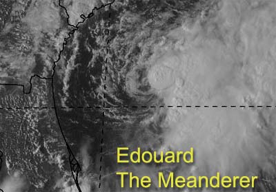
Edouard is going to aggrivate us all most of this week while it just meanders willy nilly around our coasts.
Models suggest that it will do a cyclonic loop and head soutwest into North Florida or Georgia. However this won't be for a while. The good news is that there is shear there, and will keep strengthening of the system in check. But the proximity will cause it to remain a concern even in Central Florida for a while. In fact, the tropical storm watch still remains in effect north of Titusville into South Carolina.
The North Central Gulf, right now, is not favorible for development, but soon this may change as well. I don't think much will come of that one personally, but again proximity to land makes us keep watch on it.
Melbourne Radar - Long Range
Jacksonville Radar - Long Range
Dolly still is a fish spinner.
NRL Monterey Marine Meteorology Division Forecast Track of Active Systems (Good Forecast Track Graphic and Satellite Photos)
NASA GHCC Interactive Satellite images at:
North Atlantic Visible (Daytime Only), Infrared, Water Vapor
Some forecast models:
NGM, AVN, MRF, ETA ECMWF
DoD Weather Models (NOGAPS, AVN, MRF)
AVN, ECMWF, GFDL, MM5, NOGAPS, UKMET
Other commentary at Mike Anderson's East Coast Triopical Weather Center, Accuweather's Joe Bastardi, Hurricane City, Gary Gray's Millennium Weather, Barometer Bob's Hurricane Hollow, Snonut, Ed Dunham and Jason M in our Storm Forum Even more on the links page.
- [mike@flhurricane.com]
| troy2 |
| (Storm Tracker) |
| Mon Sep 02 2002 10:01 PM |
|
|
http://www.nrlmry.navy.mil/tc-bin/tc_home
shows it(edouard) doing the northern loop but moving toward land a bit further south than N Florida/S Georgia
that kind of path would not be good for the shoreline along Flagler Beach. A1A along there is so close to washing out.
troy
| ShawnS |
| (Storm Tracker) |
| Mon Sep 02 2002 10:22 PM |
|
|
do you really think something can get going out there? I have my doubts but if you think that it could happen than that is good enough for me. I just think it is one of those situations,again, where there is just not enough time for it to pop because of its closeness to land. Also, the actvity will more than likely die off overnight and it would have to go through the whole process of reforming tomorrow. There isn't enough time for it to keep doing that.
| troy2 |
| (Storm Tracker) |
| Mon Sep 02 2002 10:41 PM |
|
|
http://www.srh.noaa.gov/radar/loop/DS.p20-r/si.kmlb.shtml
someone else take a look at the long range loop and see if looks like it has abit of a south to that east movemnet.
what i was basing it on was the ball of stronger converction that is moving just a hair south of E
troy
| Steve |
| (Senior Storm Chaser) |
| Mon Sep 02 2002 10:58 PM |

|
|
|
>>do you really think something can get going out there? I have my doubts but if you think that it could happen than that is good enough for me. I just think it is one of those situations,again, where there is just not enough time for it to pop because of its closeness to land. Also, the actvity will more than likely die off overnight and it would have to go through the whole process of reforming tomorrow. There isn't enough time for it to keep doing that.
I agree with you about the proximity of land and timing issues, but there will still be something on the surface map by Wed. morning. Whether it's a capital "L" or the smaller, fat one they use for depressions remains to be seen. So it either comes ashore as a TD or it's another wasted landfall for LA/TX (that would be 3 so far this year).
We're supposed to get our fair share of precip tomorrow. Most of the rain today has been south of the city, but still sporadic. At least it LOOKS good with the banding and circular look to everything. I wouldn't be surprised if some areas in TX get 5-10" of rain by Friday. The threat lessens if all of the moisture rides into Louisiana Tomorrow.
Steve
| Cycloneye |
| (Storm Tracker) |
| Mon Sep 02 2002 11:31 PM |
|
|
Well this storm has made everyone guessing including the folks of the NHC.The steering corrents are light so it wont move much maybe looping around.
Today Dr Grays final 2002 report came out and he again downgraded his forecast to 8/3/1 because he says that el nino will be a key factor as it is going to be moderate he says.The whole report you can read it and judge for yourself if you agre or disagree with it by the way here is the link to his forecast.
http://hurricane.atmos.colostate.edu/forecasts/2002/sep2002/
| ShawnS |
| (Storm Tracker) |
| Mon Sep 02 2002 11:34 PM |
|
|
The NRL page doesn't even show an invest on the activity in the gulf yet. That should tell us something about the chances of it doing anything.
| troy2 |
| (Storm Tracker) |
| Mon Sep 02 2002 11:36 PM |
|
|
http://www.hurricanealley.net/mdltrpatlt02.html
models starting to look like a squashed spider again...
| 57497479 |
| (Weather Master) |
| Tue Sep 03 2002 12:16 AM |

|
|
|
So let's say that ED wants to take a trip farther into the Atlantic as some of the models are indicating. What could be the end result?
Give me something to think about guys! At this point the Atlantic sounds better than pointing directly at me. Toni
| HanKFranK |
| (User) |
| Tue Sep 03 2002 12:18 AM |

|
|
|
trying to figure out what edouard is going to do is sort of a pot shot. the depth of the storm at any particular time, paired with dry air entrainment and subtle changes in the flow around the storm are tough call variables.. but the consensus has center more around a looping meander for the meanwhile and then back to the west. this i can buy. however, with the slow movement shear and upwelling will be the big threats to the storm here. hard to see much intensification, unless the gfdl is for once seeing and not exaggerating wildly.
back towards the coast somewhere between brunswick and daytona seems reasonable enough, though i realize this is around 150 miles of coastline, and the storm is only 200 or so away. hit timetable is within 12 hours of 9pm thursday, best guess. intensity 50 to 60kt. should the storm drop sw then it could be much stronger... though seems less likely at this point.
upstream changes are another concern. the disturbance south of louisiana has ridging aloft aided by the upper low to its SW, and an exit jet going straight at edouard. this jet is all that stands between edouard and the coast, as it is keeping the storm checked. should the gulf system try to develop this jet could consequently further impede edouard. bastardi sees some potential here, though it lacks concentrated deep convection. might try some late hour development off the texas coast tomorrow or wednesday.
still not as convinced of dolly's neat recurvature as others, think that the shear will decouple the system. the inter-trough disturbed weather to the north near bermuda is looking lively, by the way, as models earlier forecast. dead dolly may mean another live system up there.
the summer noreaster off jersey would be a tropical storm had it developed faster. if it develops a deep convection core maybe a subtrop.
invest came on the system that emerged from africa, but d numbers have dropped. nrl wasnt showing this invest, but ssd had it pegged. convection went out the door though, so no early development here. system out ahead at 35w doesnt look as good either, but may try something just east of the islands in dolly's wake in just a couple of days. whatever comes behind dolly is going to be trouble.
whatever happened to the carib wave, i wonder. lost its mojo, not looking feisty at all. just have to monitor for it possibly coming back.
HF TLH 0012z03september
| Hurric |
| (Weather Guru) |
| Tue Sep 03 2002 12:37 AM |

|
|
|
I think its a crapshoot trying to guess Ed's movements. Happy to have something of interest to be tracking this weekend.
At this time experiencing strong Thunderstorm with heavy rain, gusty winds, and some wicked Litening.
I am in Port St. Lucie which is just south of Fort PIerce on this radar link from Melbourne.
The squall line extends NE up to Ed. Thinking this will be about the most We'll be seeing of him down this way.
http://www.srh.noaa.gov/radar/loop/DS.p20-r/si.kmlb.shtml
Happy tracking
Hurric
| Unregistered User |
| (Unregistered) |
| Tue Sep 03 2002 01:26 AM |
|
|
How much should we read into the GFDL, is Palm Coast in Eds path?
| HanKFranK |
| (User) |
| Tue Sep 03 2002 02:10 AM |
|
|
|
|
add another mitigator: subsidence. the upper shortwave has gone by to the north, but the dry air slot following the upper trough is going to choke edouard while shear smears it. there is a lot of subsidence, by the way. even if this doesnt kill edouard outright, will probably push the storm east a good bit. after a day or so things should get better.
HF 0207z03september
| Unregistered User |
| (Unregistered) |
| Tue Sep 03 2002 02:50 AM |
|
|
Now the GFDL is having it enter north of Jacksonville, Exiting around Appalachacola and then moving west about 50-100 miles off shore.
In other words, only the shadow knows.
| Unregistered User |
| (Unregistered) |
| Tue Sep 03 2002 02:59 AM |
|
|
And while the GFDL switches North, the NHC moves it slightly south.
| Unregistered User |
| (Unregistered) |
| Tue Sep 03 2002 03:46 AM |
|
|
18z GFDL most ominous to date. I'm dying to see what it's gonna do tomorrow.
Steve
| HanKFranK |
| (User) |
| Tue Sep 03 2002 04:09 AM |
|
|
|
|
thinking maybe the center will have to work its way south for the storm to survive, kinda develop towards where the convection can stablilize it. there is a narrow ridge axis not 200 miles south of the current position... thats the only fix i see for edouard. so yeah, florida problem or nobody's problem.
pesky area between the yucatan and louisiana might become a home grown problem by wednesday.
HF 0405z03september
| Unregistered User |
| (Unregistered) |
| Tue Sep 03 2002 04:20 AM |
|
|
http://www.accuweather.com/adcbin/video_index.asp
Click on the "Dance of Edouard" by Bastardi. Food for thought. Neither did I get my original Gulf idea from this week from Bastardi nor did I get the 2x FL Landfall potential from GFDL. Calls out the ether. Anyway, this one is for us. We get left out all the time, but the presentation of this video should remind us all that we need to watch. The Gulf is ripe if anything is there.
Steve
| Unregistered User |
| (Unregistered) |
| Tue Sep 03 2002 04:22 AM |
|
|
I know you explained this to me once, but you're at FSU, right? My younger brother is a grad of FSU. Our whole family are Noles fans. Tally is a cool place. There are all kinds of 1-3 hour MUST road cruises. Itchatucknee Springs, Lake Seminole, St. George.
Don't I wish.
Steve
| Unregistered User |
| (Unregistered) |
| Tue Sep 03 2002 11:25 AM |
|
|
Ed is a bit more menacing tihs morning. TPC has taken a N jog out of the official forecast and brings Ed over NE or C FL as a TS about the same intensity. New GFDL run continues trend of dual landfall.
Gulf looks better than ever. It almost looks baroclinical in the way the convection is coming into LA, but I don't think it rained much here overnight. In any event, trend for increase continues. I still am thinking "L" on the map by tomorrow, and probably a few inches of rain in parts of TX. Maybe 2-3 in some parts of LA today. NDBC is down at the moment, and I haven't checked the NWS radar to see what's actually happening in the way of precip.
Steve
| tom5r |
| (Weather Watcher) |
| Tue Sep 03 2002 11:52 AM |
|
|
J. Bastardi, after mounds of explaination still allows for the possibility that Eddy will circle back around thursday and cross central Florida, moving into the Gulf and then possibly forming into a hurricane. With all these details in the science of weather forecasting I find it amazing that my dear old dad could tell me what was gonna happen from his aching back.
| Mike |
| (Weather Watcher) |
| Tue Sep 03 2002 12:30 PM |
|
|
While Florida has pays close attention to "Ed'. The NRL has started a invest 95L northwest of CV.
| Unregistered User |
| (Unregistered) |
| Tue Sep 03 2002 12:33 PM |
|
|
Steve, its tryin but its gonna run out of room. Here in Cameron, SW LA winds are out of the ENE steadily increasing about 15-20 now. Low Cloud Deck moving quickly to the South West.
| Unregistered User |
| (Unregistered) |
| Tue Sep 03 2002 12:34 PM |
|
|
WTNT35 KNHC 031207
TCPAT5
BULLETIN
TROPICAL STORM EDOUARD INTERMEDIATE ADVISORY NUMBER 7A
NATIONAL WEATHER SERVICE MIAMI FL
8 AM EDT TUE SEP 03 2002
...CORRECTED ADVISORY TIME FROM 5 AM TO 8 AM...AND UPDATED POSITION
AND INTENSITY FOR RECENT RECONNAISSANCE DATA...
...EDOUARD STRENGTHENS...STILL STATIONARY...
A TROPICAL STORM WATCH REMAINS IN EFFECT FROM FLAGLER BEACH
FLORIDA TO FERNANDINA BEACH FLORIDA.
AT 8 AM EDT...1200Z...THE CENTER OF TROPICAL STORM EDOUARD WAS
LOCATED NEAR LATITUDE 30.4 NORTH...LONGITUDE 78.4 WEST OR ABOUT
195 MILES EAST OF JACKSONVILLE FLORIDA.
EDOUARD IS CURRENTLY NEARLY STATIONARY. A DRIFT TOWARD THE WEST OR
SOUTHWEST MAY BEGIN LATER TODAY.
REPORTS JUST RECEIVED FROM A RECONNAISSANCE AIRCRAFT INDICATE THAT
EDOUARD HAS STRENGTHENED. MAXIMUM SUSTAINED WINDS ARE NEAR 50
MPH...WITH HIGHER GUSTS. SOME ADDITIONAL INCREASE IN STRENGTH IS
POSSIBLE DURING THE NEXT 24 HOURS.
TROPICAL STORM FORCE WINDS EXTEND OUTWARD UP TO 105 MILES...165 KM
MAINLY TO THE EAST OF THE CENTER.
ESTIMATED MINIMUM CENTRAL PRESSURE IS 1002 MB...29.59 INCHES.
REPEATING THE 8 AM EDT POSITION...30.4 N... 78.4 W. MOVEMENT
...STATIONARY. MAXIMUM SUSTAINED WINDS... 50 MPH.
MINIMUM CENTRAL PRESSURE...1002 MB.
FOR STORM INFORMATION SPECIFIC TO YOUR AREA...PLEASE MONITOR
PRODUCTS ISSUED BY YOUR LOCAL WEATHER OFFICE.
THE NEXT ADVISORY WILL BE ISSUED BY THE NATIONAL
HURRICANE CENTER AT 11 AM EDT.
FORECASTER FRANKLIN
| Cycloneye |
| (Storm Tracker) |
| Tue Sep 03 2002 12:50 PM |
|
|
A surprise for many as Edouard gets stronger as shear is more weak and the center is less exposed.
| Jax Chris |
| (Weather Watcher) |
| Tue Sep 03 2002 12:53 PM |
|
|
I hope the NHC's forecast track is correct, although I could stand for the intensity to be less than TS when it hits the coast. I was at my parents' yesterday, which is on one of the lakes in central Florida, near Melrose (~20 miles east of Gainesville). Their lake level needs to rise at least five feet to get the water back to the ends of the docks, and another six or so feet above that would be nice. You drive over a bridge and there are signs on it that say, "No Diving"...which is a good idea, considering that the nearest water is hundreds of yards away. Although the lake level there has risen in the past month, it still wouldn't hurt to have a few storms come though and help out. That area of the state is also where some of the aquifers get filled, so their getting a good soaking there will help more than just the locals.
Anyway, I guess it's just sit and see what Eduoard decides to do. Pressure at last report was still 1005, so he's not currently thinking about serious intensification. Hopefully if the westerly flow lets up and permits Ed to start moving towards the coast, he won't have time to get better organized before hitting land.
Chris
| Jax Chris |
| (Weather Watcher) |
| Tue Sep 03 2002 12:58 PM |
|
|
Yes, nice of the NHC to report that the pressure's dropped to 1002 while I'm in the middle of typing a message saying it was last reported at 1005. You know, they need to coordinate these things better...
Chris
| Rasvar |
| (Weather Master) |
| Tue Sep 03 2002 01:34 PM |

|
|
|
I'm not liking the latest run of the GFDL. Especially since it usually overintensifies a system but is already under currents. I have to say that this forecast seems reasonable, sans intensity forecast. I guess it is possible for a Cat 1 before it hits Florida, especially with the current surprise. Central Florida can do witthout anything that strong. Saturated ground conditions would make for a lot more falling tress then usual, not too mention flooding in areas already doing bad. I'm hoping it keeps up in North Central Florida becuase they need the rain. However, The forecast keeps slipping south. :P
| Unregistered User |
| (Unregistered) |
| Tue Sep 03 2002 01:50 PM |
|
|
If the GFDL is right this could be a major major event riding the Gulf Coast all the way to SE TX, SW LA. Wow what a difference a day makes. By the way I believe we ave a depression forming south of vermillion Bay.
| Unregistered User |
| (Unregistered) |
| Tue Sep 03 2002 02:09 PM |
|
|
Vermillion Bay. Where is that?
| garyb |
| (Weather Guru) |
| Tue Sep 03 2002 02:15 PM |
|
|
DISCLAIMER...NUMERICAL MODELS ARE SUBJECT TO LARGE ERRORS.
PLEASE REFER TO TPC/NHC OFFICIAL FORECASTS FOR TROPICAL CYCLONES.
TROPICAL STORM EDOUARD (AL052002) ON 20020903 1200 UTC
...00 HRS... ...12 HRS... ...24 HRS...
020903 1200 020904 0000 020904 1200
LAT LON LAT LON LAT LON
BAMD 30.4N 78.4W 30.2N 77.5W 29.7N 77.0W
BAMM 30.4N 78.4W 30.1N 78.5W 29.7N 78.9W
A98E 30.4N 78.4W 30.5N 78.3W 30.3N 77.4W
LBAR 30.4N 78.4W 30.3N 78.1W 30.4N 78.1W
SHIP 50KTS 58KTS 63KTS
DSHP 50KTS 58KTS 63KTS
...36 HRS... ...48 HRS... ...72 HRS...
020905 0000 020905 1200 020906 1200
LAT LON LAT LON LAT LON
BAMD 29.4N 76.8W 29.2N 76.5W 30.0N 76.7W
BAMM 29.3N 79.4W 28.9N 79.9W 28.7N 80.8W
A98E 29.8N 76.3W 29.9N 75.2W 30.3N 72.6W
LBAR 30.4N 78.4W 30.2N 78.5W 30.2N 78.1W
SHIP 66KTS 71KTS 75KTS
DSHP 66KTS 71KTS 32KTS
...INITIAL CONDITIONS...
LATCUR = 30.4N LONCUR = 78.4W DIRCUR = 100DEG SPDCUR = 1KT
LATM12 = 30.5N LONM12 = 78.7W DIRM12 = 103DEG SPDM12 = 2KT
LATM24 = 30.4N LONM24 = 79.6W
WNDCUR = 50KT RMAXWD = 10NM WNDM12 = 35KT
CENPRS = 1002MB OUTPRS = 1012MB OUTRAD = 120NM SDEPTH = M
RD34NE = 60NM RD34SE = 90NM RD34SW = 20NM RD34NW = 20NM
| Unregistered User |
| (Unregistered) |
| Tue Sep 03 2002 02:20 PM |
|
|
Vermillion Bay is in central Louisiana
| Unregistered User |
| (Unregistered) |
| Tue Sep 03 2002 02:32 PM |
|
|
I feel hurricane watch is coming soon. Flit Level 71 knts.