MikeC
|
| (Admin) |
| Sat Sep 21 2002 09:20 PM |
|
|
6PM Update
Isidore... Recon found pressure down to 945mb, Eyewall is reforming and is half open on the western side.
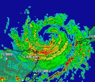
Radar from Cancun
Originial Update
The tropics have come alive.
We have the wanderer Isidore, still crawling in the Southeast gulf, still unsure on it's future, nearing Category 4 status. Kyle, meandering around in the middle of the Atlantic, and TD#13 that just formed that will be threatening the Eastern Caribbean islands.

The big question... Do we know any more on Isidore? The answer is no, the northerly turn is still a possiblity, but right now there is no real movement. West, sorta, maybe north a bit, maybe south a bit, kinda. It's wobbling right now (northwest from what I saw), and we'll have to watch the trends. Nothing new on this so far. Continue to keep watch.
Tons of rain is still occuring on Jamaica and western Cuba, amazing amounts in fact.
Jim Williams (Hurricane City) and Barometer bob are doing live Audio shows starting at 8PM and lasting usually to 10 or 11PM all during Isidore's run. Use the link below to check them out.
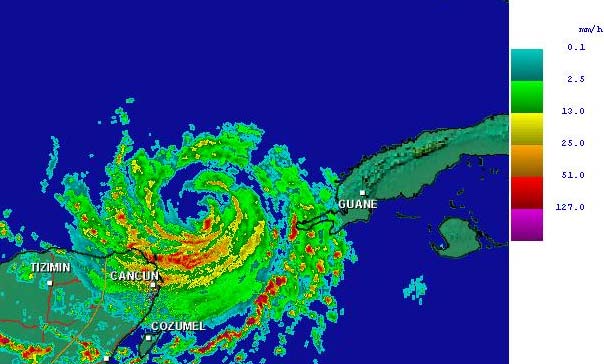
Cancun, Mexico Radar
NRL Monterey Marine Meteorology Division Forecast Track of Active Systems (Good Forecast Track Graphic and Satellite Photos)
NASA GHCC Interactive Satellite images at:
North Atlantic Visible (Daytime Only), Infrared, Water Vapor
Some forecast models:
NGM, AVN, MRF, ETA ECMWF
DoD Weather Models (NOGAPS, AVN, MRF)
AVN, ECMWF, GFDL, MM5, NOGAPS, UKMET
Other commentary at Mike Anderson's East Coast Tropical Weather Center, Robert Lightbown/Crown Weather Tropical Update Accuweather's Joe Bastardi, Hurricane City Weather Audio Broadcast Network - Live Audio from Jim Williams and Barometer Bob , Tropical Weather Watchers.Com (JasonM) Gary Gray's Millennium Weather, Barometer Bob's Hurricane Hollow, Snonut, Ed Dunham and Jason M in our Storm Forum Even more on the links page.
- [mike@flhurricane.com]
| Domino |
| (Weather Guru) |
| Sat Sep 21 2002 09:30 PM |
|
|
I certainly agree with the others that there was some NW track however the last frame or two seems to turn it back due west. The discussion seems they really wanted to have higher winds for this update but just couldn't find the justification for it. When the eyewall closes off sounds like we'll have a Cat 4.
| clyde w. |
| (Storm Tracker) |
| Sat Sep 21 2002 09:30 PM |
|
|
There is a link in the news item to the NASA GHHS Satellite, where you can zoom in--ya'll probably know this. Anyway, centering the cursor directly over the eye in the latest image yields the coordinates 20.06N and 86.23W. It sure looks like he's jogged N or NW over the last hour.
| clyde w. |
| (Storm Tracker) |
| Sat Sep 21 2002 09:32 PM |
|
|
Here's a better link. The eye is definitely north of 22N:
http://www.nrlmry.navy.mil/tc-bin/tc_home
|
MikeC
|
| (Admin) |
| Sat Sep 21 2002 09:38 PM |
|
|
The cancun radar link I mentioned is mega slow. Here's an image I managed to grab for everyone:
| Unregistered User |
| (Unregistered) |
| Sat Sep 21 2002 09:43 PM |
|
|
all models have izzy going to see shawn in texas gulf coasters can take a nap now if he dont head north soon
| HanKFranK |
| (User) |
| Sat Sep 21 2002 10:22 PM |

|
|
|
thats funny. 12z avn suggests a landfall near tx/la border. thats one model run out of many models that has it going to texas. perhaps you should reconsider what you just wrote, anon.
eyewall cycles will probably make intensity about as erratic as movement next few days. everybody has jumped on the nw jog.. which has been maybe 15 miles. considering it moved about 75 miles wsw this morning, i wouldnt put much stock in that.
looks like the three that are going to go have already gone. after td 13, which should be lili by some time tomorrow.. other systems are going to struggle to develop and probably not succeed. until the upper low begins to spin down east of florida i cant see anything getting well organized in there.. in spite of jumpy but intense convection. system near the cape verdes has more shear to negotiate than its predecessor.. might get turned up right away, or might just struggle westward and try again next week.
unless october is deathly quiet, may get to sample some previously unused storm names.. perhaps omar, or the dreaded paloma.
HF 2225z21september
HF
| Unregistered User |
| (Unregistered) |
| Sat Sep 21 2002 10:28 PM |
|
|
I agree with Hank I dont think anyone around the gulf is outta the woods. I agree that after awhile the storm will turn north then maybe north east an make landfall somewhere in the central gulf around where hanna was maybe? thats just a guess though. where is everyone at i like readin all 100 post an hour haha
| meto |
| (Weather Guru) |
| Sat Sep 21 2002 10:40 PM |
|
|
landfall could be south of big bend of fla. more south down west coast of fla. look at mm5-135 interesting......
| meto |
| (Weather Guru) |
| Sat Sep 21 2002 10:53 PM |
|
|
he's moving slightly west of north, it could be just a bump but maybe not too. hurricane that is this powerful can form its own inviroment and movement.
| Robert |
| (Weather Analyst) |
| Sat Sep 21 2002 10:55 PM |

|
|
|
Interesting events, Ships model bring izzy to 140 knts cat 5 baby, but that remains to be scene it would not suprise me though considering we have 125 mph winds with non complete eyewall and extremely warm waters. Ne who i have real strong feeling by the end of this coming week we could be down three majors, kyle forcast to sit around and get to 70knts it looking better on sat and getting bigger would not suprise me to se this get to a 3 then there is td13 wich is forcast to be 91knts in 72 hours by ships and 65 by nhc and chances are it to will be a major in time its starting to wrap up nicelly and unlike izzy probally wont be efected by south america.
| Unregistered User |
| (Unregistered) |
| Sat Sep 21 2002 11:32 PM |
|
|
izzy is moving noth last few frames storms on gulf coast luck stang like they came of the gulf could izzy be filling a pulse any feed back press droping at bouy 260 south of p. city lowest in north gulf plus keys lower now than 24 hours ago i no izzy is growing just looking
| clyde w. |
| (Storm Tracker) |
| Sat Sep 21 2002 11:33 PM |
|
|
You're right Hank, I shouldn't have implied that it the NW direction was any more than a wobble? Let me ask you, the fact that Izzy hasn't hit 6 kts all day, wouldn't the logical conclusion of this be that if/when he does turn north, points further east, such as the AL/FL border may be slowly moving back under the gun? What do you think?
| Steve |
| (Senior Storm Chaser) |
| Sat Sep 21 2002 11:43 PM |

|
|
|
>>or the dreaded paloma
Could it be?
>>izzy is moving noth last few frames storms on gulf coast luck stang like they came of the gulf could izzy be filling a pulse any feed back press droping at bouy 260 south of p. city lowest in north gulf plus keys lower now than 24 hours ago i no izzy is growing just looking
Could it be? Matthew back? John in South Florida? Paloma? Judy Garland have 13 said birthday you mean of that to buoy.
Steve
| Londovir |
| (Weather Guru) |
| Sat Sep 21 2002 11:44 PM |
|
|
Okay, I'm just looking at the loop of satellite imagery from the Cuban weather service, and though I'm not sure at the resolution shown for the satellite image, it looks for sure like the eye of the storm from 2:45pm until 6:15pm was wobbling practically north, or maybe a little west of north. Maybe I'm not seeing things right....
Cuban Satellite Loop
Hopefully I'm either off my gourd, or this was just a wobble and not a sign of a recurve or something. Holding breath and waiting....
Jay
| Kimster |
| (Weather Hobbyist) |
| Sat Sep 21 2002 11:57 PM |

|
|
|
I see the NNW track also. Other radar satellites are showing it too. Tough to predict the hurricanes future track, isn't it?
| Frank P |
| (Veteran Storm Chaser) |
| Sat Sep 21 2002 11:58 PM |
|
|
I've been plotting what I estimate to be the center of Izzy... not sure how accurate my method is but I think you can get reasonably close...
in the past 30 minutes the system has moved from 22.21N to 22.29N .09 degrees north... and from 86.47W to 86.50 W .03 degrees west...
Its now close to 22.3N (if my estimates are correct) and this is farther north than all the models said it would be at this time..
granted all I'm doing is zooming on the GOES IR, putting the cursor in what I think is the center of the eye, and reading what it says...
not very scientific but something to play around with...
| Kimster |
| (Weather Hobbyist) |
| Sun Sep 22 2002 12:01 AM |
|
|
|
|
Frank,
Please provide the link where you can zoom in. I have tried a few time to no avail. Thanks Kim
| canman32 |
| (Verified CFHC User) |
| Sun Sep 22 2002 12:11 AM |
|
|
Even the latest updates show a more WNW movement, yet the weather channel continues to call it a westward motion.?
At 7pm central -LATITUDE 22.1 NORTH...LONGITUDE 86.4 WEST, it was 21.9 North and 86.1 West before.
| meto |
| (Weather Guru) |
| Sun Sep 22 2002 12:17 AM |
|
|
look at cancun radar
| Frank P |
| (Veteran Storm Chaser) |
| Sun Sep 22 2002 12:21 AM |
|
|
During the past 45 minutes I estimate that Izzy has gone .09N and .09W.... I think it is still jogging to the wnw or nw for the past hour or so... again based on my non scientific method
Kimster here's the link... sorry it took so long as my computer locked up and I had to reboot
http://wwwghcc.msfc.nasa.gov/GOES/goes8conusir.html
| joepub1 |
| (Storm Tracker) |
| Sun Sep 22 2002 12:22 AM |
|
|
Hey guys(and gals). Came back from getting my wife from work and looked at infrared loop. Think there still is some nw jogs going on. I kind of brought this up on the last page, but my thoughts are we've gone almost nine hours with either no movement or a very slow NW jog. This should be enough to throw out some of the stranger model aspects IMHO, like Izzy being somewhere way down in the Bay of Camp. in 72hrs. But I'm willing to bet NHC won't budge, and at 11 we'll get something that is a rehash of the 11:00 am forecast. Even the 18Z GFDL gives me problems because they started Izzy in the right place, but going the wrong direction. 265, or just south of west? Anybody seen him going south of west today? Sorry, it's just something that gets on my nerves when peoples lives are at stake. When you feed a model garbage, it's going to give you garbage in return.
Of course, I think Izzy was just trying to get a better look at the GATORS STOMPING TENNESSE 30-13! He's just adjusting his rabbit ears, IMHO.
Joe in Jax
| Kimster |
| (Weather Hobbyist) |
| Sun Sep 22 2002 12:26 AM |
|
|
|
|
Thanks Frank...even got it to zoom for me!
| Londovir |
| (Weather Guru) |
| Sun Sep 22 2002 12:27 AM |
|
|
Excellent link, Frank! Lets you really get zoomed in and see the eye area nicely. Looks like the western tip of Cuba is in for some really nasty rain and weather for the next few hours as that trailing arm of Izzy whips into it from the south.
Looking at the Cancun radar it looks like the worst of the close-core rains are skimming just off shore. Guess that's good for the poor folks living up on the peninsula --- bad for everyone else in terms of it not weakening much since it looks like the core is going to stay off land.
Jay
| Frank P |
| (Veteran Storm Chaser) |
| Sun Sep 22 2002 12:31 AM |
|
|
anytime K
Bama opening up a can of whoop ass on my Golden Eagles... Jason and Southern4sure should be enjoying this .... cause I sure in the heck am not
Izzy not going anywhere very fast is he???
Got to admit the color IR on this system is just absolutely beautiful .... hope I can continue to view it from a safe distance...
| joepub1 |
| (Storm Tracker) |
| Sun Sep 22 2002 12:42 AM |
|
|
Very nice link. Boy, he's pushing that upper low to his SW away like a rotten stepchild, much like the GATORS DID TO TENNESSE!
But very nice link, indeed.
| Frank P |
| (Veteran Storm Chaser) |
| Sun Sep 22 2002 12:49 AM |
|
|
Just got thru reviewing the Cuba sat loop. System has over the past 5 hours definitely wobbled on a definite NW course...
the link was provided up above in an earlier post but here's the link, it's slow but worth the view...
http://flhurricane.com/cyclone/newreply.php?Cat=&Board=tb2002&Number=4672&page=0&view=collapsed&what=showflat&sb=5&o=&fpart=1&vc=1
| Steve |
| (Senior Storm Chaser) |
| Sun Sep 22 2002 12:53 AM |
|
|
|
|
quasi-stationary. It appears to me that the eye is almost rotating around the CDO which appears to be slightly elongated. As it comes around, sometimes it's going north, sometimes south west, sometimes west. Imagine you're drawing a series of connected, lowercase, script e's but you don't loop the 'e' - almost the shape of a wave you might have drawn in a beach picture in kindergarden - but not exactly. Overally, the eye looks to miss the YP as it is a bit north of there. If you plot the eye short term (last few hours), you'd come up roughly northwest, yet the storm itself seems to be crawling west. The slow movement almost guarantees a NC-NE Gulf landfall if it gets grabbed by a trof. Interestingly, the European model for the severalth run in a row puts landfall around Morgan City, LA. 2 days later, it's up in northern Ohio. That's a rocket shot if ever I saw one. I'm not sure which model will perform best when the researchers go back and look at 'em, but if the Euro is right, there's going to be a lot of dead alligators on the coast!
Here's a link to the latest ECMWF I could find:
http://www.ecmwf.int/products/forecasts/d/charts/deterministic/world/msl_uv850_z500!Wind%20850%20and%20mslp!168!North%20America!12!pop!od!oper!public_plots!latest!/
Steve
| Steve |
| (Senior Storm Chaser) |
| Sun Sep 22 2002 12:57 AM |
|
|
|
|
http://www.essc.psu.edu/rhart-cgi-bin/gfdltc2.cgi?time=2002092118-isidore10l&field=Sea+Level+Pressure&hour=Animation
Steve
| Frank P |
| (Veteran Storm Chaser) |
| Sun Sep 22 2002 01:05 AM |
|
|
Last IR pix showed a wobble west.... .04W degrees and no movement north... Steve you might be right but add it all up from the past 90 minutes the system went from 22.21N to 22.3N (.09N) and from 86.47W to 86.60W (.13W)
All based on guestimates but still drifting somewhere between WNW and NW... NOT WEST..
Next IR pix should be interesting... wobble more to the NW should occur if this is a true trend...
Wobbles are part of the phenomon of a storm and you would expect it to go north then west, back on forth if it truly is moving NW... especially if you are trying to plot every 15 minutes or so... lets see what the next IR brings.... one thing about it, not hard to find the center of this sucker...
| troy2 |
| (Storm Tracker) |
| Sun Sep 22 2002 01:09 AM |
|
|
http://www.ssd.noaa.gov/PS/TROP/DATA/RT/watl-ir4-loop.html
looking as if TD13 is getting som eof its convection back.
| Londovir |
| (Weather Guru) |
| Sun Sep 22 2002 01:12 AM |
|
|
You aren't kidding about tricks...if I read that right, the plot on that site wants to take it on a hard curl over the tip of the YP, practically coming back southeastward until it bounces off the western edge of the YP, then it rebounds back NW. Somehow I don't see the storm hooking downwards like that, but this storm will pretty much do anything it wants to I guess.
Jay
| Frank P |
| (Veteran Storm Chaser) |
| Sun Sep 22 2002 01:15 AM |
|
|
latest IR still shows it drifting off to the wnw... I don't think its stationary... slowly drifting.. I have it at 22.32N and 86.69W
over the past hour and 45 minutes Izzy has gone 1.1 degrees north (form 22.21n to 22.32N) and 2.2 degrees west (from 86.47W to 86.69W)... granted not all that much movement but movement still the same
| meto |
| (Weather Guru) |
| Sun Sep 22 2002 01:15 AM |
|
|
its not moving west, cant count on models they are dealing with something very different.
| BillD |
| (User) |
| Sun Sep 22 2002 01:16 AM |
|
|
Drifting westward is what the NHC said, and that is what I'm seeing on the Cancun radar. I've been grabbing the graphic from there every 1/2 hour or so, I put some of them up side by side, and the center has barely moved over the last couple of hours, but I see only a westward component.
Bill
| Floridacane |
| (Weather Guru) |
| Sun Sep 22 2002 01:21 AM |

|
|
|
http://wwwghcc.msfc.nasa.gov/cgi-bin/post-goes
Frank, here's the zoom in on that link you posted, pretty awesome eye wall. Thanks for the link.
Lori
| Floridacane |
| (Weather Guru) |
| Sun Sep 22 2002 01:23 AM |
|
|
|
|
Sorry, don't know what happened to the link, won't let me post it. So anyway, ignore my last post
| Kimster |
| (Weather Hobbyist) |
| Sun Sep 22 2002 01:28 AM |
|
|
|
|
http://wwwghcc.msfc.nasa.gov/GOES/goes8conusir.html
| Frank P |
| (Veteran Storm Chaser) |
| Sun Sep 22 2002 01:30 AM |
|
|
Bill do you have a link to a Cancun radar that loops.. that would certainly help determine if it is moving... from what I've seen on the IR I 'm reasonable sure it has moved some, but not much, over the past hour.... my opinion only...
with such a well defined center iis pretty easy finding its whereabouts...
| Steve |
| (Senior Storm Chaser) |
| Sun Sep 22 2002 01:43 AM |
|
|
|
|
Bobbi,
I want your read on 'colors.' I'll check back later. Also, for anyone who cares, Bastardi will be doing another late PM post on the tropics tonight. I care, that's why I posted it. I don't know why it's gotten so vogue to trash him, but I think he's the best there is.
Steve
| meto |
| (Weather Guru) |
| Sun Sep 22 2002 01:44 AM |
|
|
mike anderson says ridge over fla. is weakining tonight, i said this the other day.
| Frank P |
| (Veteran Storm Chaser) |
| Sun Sep 22 2002 01:46 AM |
|
|
latest IR had it going due west... I have it at approximately 22.31N and 86.87W
during the past 90 minutes Izzy has gone due west .27 degrees... quite evident on the GOES IR...
there has been NO northerly component in its track in the past 90 minutes
| joepub1 |
| (Storm Tracker) |
| Sun Sep 22 2002 01:48 AM |
|
|
It looks like the eye wall is getting it's act back together, appearing much more defined in the last couple of frames, with a slight lean to wnw. He's in no hurry.
On another note, BAMD,BAMM,A98E and LBAR seem to be trying to set up Kyle and Lile on a blind date in the near future, bringing them close enough to each other to prob. interact in some way. Gee, I don't think that sounded quite right, but you know what I mean.
That didn't sound right either. I'll give up on that line for awhile.
Joe in Jax
|
MikeC
|
| (Admin) |
| Sun Sep 22 2002 02:02 AM |
|
|
I put together a 3 frame animation from the frames I have from the cancun radar.
I'll add more as I get them (one about every 15 minutes or so)
Cancun Loop made by MikeC
| BillD |
| (User) |
| Sun Sep 22 2002 02:06 AM |
|
|
Frank there isn't one that I know of. I was capturing the still images and comparing them side by side. I've figured out how to animate them, but it doesn't look like there's any way to post a graphic on the board.
Bill
|
MikeC
|
| (Admin) |
| Sun Sep 22 2002 02:12 AM |
|
|
Bill email me it and I'll post it mike@flhurricane.com
| Frank P |
| (Veteran Storm Chaser) |
| Sun Sep 22 2002 02:12 AM |
|
|
thanks anyway Bill
Looks like Mike's got a link to a loop he pulled together... after reviewing Mike's loop I still say the system is drifting off to the west or just north of west..
thanks Mike for the link
| Unregistered User |
| (Unregistered) |
| Sun Sep 22 2002 02:15 AM |
|
|
mike said on his report that the high to the north was going away that had blocking north move as we done his report and izzy was going to move north tonight the weater channel mr stuw said h moving in will block it from gulf coast so is there a open slot to move north like mike said look at his update please respond looks like izzy moving west again
| Unregistered User |
| (Unregistered) |
| Sun Sep 22 2002 02:42 AM |
|
|
look at w/v loop another pulse coming could this do anything
| Londovir |
| (Weather Guru) |
| Sun Sep 22 2002 02:45 AM |
|
|
Mike:
I took (borrowed, stole, whichever
Cancun Radar Loop
(I notice when I tried to click to this link to test it in preview, it throws a 403 Forbidden error, but if you hit refresh, it loads fine. Bizarre anti-referral link at Roadrunner? Dunno, sorry....)
Dunno how much I'll be updating this, or how frequently, but figured I'd toss it on the list to help everyone out.
Jay
| Frank P |
| (Veteran Storm Chaser) |
| Sun Sep 22 2002 02:51 AM |
|
|
I have Issy at 22.25 N and 87.0 W... that's basically due west from the past hour or so... I estimate it has gone only approximately 30 miles in the past 4.5 hours ...
|
MikeC
|
| (Admin) |
| Sun Sep 22 2002 03:00 AM |
|
|
Thanks for the fix. Looks like the cancun radar was overloaded, it's not updating anymore. So I'm going to bed. Thanks all!
| joepub1 |
| (Storm Tracker) |
| Sun Sep 22 2002 03:01 AM |
|
|
NHC puts it at 22.2N,86.7W
Your getting pretty good at this!
| Frank P |
| (Veteran Storm Chaser) |
| Sun Sep 22 2002 03:02 AM |
|
|
Per the 11:00 discussion from the nhc
<<IF THE HURRICANE MOVES TOO FAR SOUTH INTO THE BAY OF CAMPECHE...I DOUBT IT WILL EVER MOVE NORTHWARD. IT IS NECESSARY TO HAVE VERY STRONG STEERING FLOW FROM THE SOUTH TO PULL HURRICANES OUT OF THAT AREA. >>
Hopefully this will be the scenario... last IR loop actually showed a wobble to the wsw... lets get it to the BOC and keep it there... bad for Mexico, good for the Gulf Coast..
| Frank P |
| (Veteran Storm Chaser) |
| Sun Sep 22 2002 03:08 AM |
|
|
Thanks Joe, but I think its a little farther west than what they are posting but they are the experts.. unless the GOES lat and long system is off, but I alway validate it with my own location in Biloxi, so if thats right it should be right everywhere else..
I guess it will continue to slowly drift west with maybe a wobble to the south and then north every now and then...
I think even the nhc is questioning whether or not this thing will ever get pulled north... I certainly am...
| Unregistered User |
| (Unregistered) |
| Sun Sep 22 2002 03:12 AM |
|
|
cnn had the guy from hurr center on they think west till tuesday then n/w turn maybe thret to east of miss dont seem to br one now grwet news looks more like north mex
| Steve |
| (Senior Storm Chaser) |
| Sun Sep 22 2002 03:12 AM |
|
|
|
|
Kind of ecohes what I said on Page 1 or 2 about the European. When in doubt, he almost always goes with the European in tropical matters. I don't know. Some of the low lying areas and bayous could be in for some serious trouble. People look at a map of the US and think they see Louisiana. But it looks nothing like it used to. We lose 3 football fields every day. If I can find a link to a map of what the state really looks like, I'll post it. You don't really notice it until you're flying overhead, but little by little, we're sinking away. There's a fairly good chance that the southern levee protection on the West Bank will be prime beachfront property in another 60 years.
>>After looking things over, I dont have any changes. Option 2 is re-enforced by the European tonight, and that is a major hurricane hit then a rapid northeast moving storm with heavy rains. Pressures with the storm on Saturday are still near 20.00 over Pennsylvania, after the landfall late Thursday in southeast Louisiana. Basically no changes. The UKMET holds on to its west path, but now has a landfall much closer to Brownsville. I continue to favor what was option 2, back on Thursday, which is basically what the European has.
Steve
| troy2 |
| (Storm Tracker) |
| Sun Sep 22 2002 03:12 AM |
|
|
http://www.disastercenter.com/convert.htm
a cool conversion chart
| Frank P |
| (Veteran Storm Chaser) |
| Sun Sep 22 2002 03:19 AM |
|
|
Tha's your prediction? that this thing is going to end up in SE LA coast... Morgan City?
| Steve |
| (Senior Storm Chaser) |
| Sun Sep 22 2002 03:23 AM |
|
|
|
|
http://www.lwrri.lsu.edu/cia/html/sefall.html
That's the link to what the state actually looks like now. Below are just some links of lost land since 1950. It's pretty sad because as a state, I don't think there is another one with the unique culture that we have. We used to be the only state gaining land, but now we're losing it faster than anywhere else on the planet.
http://www.lacoast.gov/maps/LandLoss/pontchartrain.htm
http://www.lacoast.gov/maps/LandLoss/Breton.htm
http://www.lacoast.gov/maps/LandLoss/mississippi.htm
http://www.lacoast.gov/maps/LandLoss/Terrebonne.htm
Steve
| Steve |
| (Senior Storm Chaser) |
| Sun Sep 22 2002 03:25 AM |
|
|
|
|
I predicted MS Coast. The EURO predicts roughly Morgan City as does Bastardi by default since he's going with "Scenario 2" from Thursday or Friday.
Steve
| joepub1 |
| (Storm Tracker) |
| Sun Sep 22 2002 03:25 AM |
|
|
Izzy may be hungry for mexican food. NHC gave a pretty good hint their begining to pass on this thing turning north to threaten northern GOM. High pressure may serve to protect the LA to FL gulf coasts, but how that will play into TD13 I don't have a clue. How strong will it build into the western atlantic, and will it also block Lili from going to the fishes? PR will be under the gun in 72hr, prob. with a Cat1. Izzy seems to have that Mitch thing going, he's made up his mind west is best, which is fine by me. I'd say unless he does a major league stall most of us are safe. If he stalls around 90W, I'll rethink it, but I don't see anything down the road to yank him way north if he goes much farther than that.
Not a clue about Karl.
Joe in Jax
Way to go Gators!
| Frank P |
| (Veteran Storm Chaser) |
| Sun Sep 22 2002 03:29 AM |
|
|
Latest IR has Izzy at 22.21N (which is the same lat he was at 4 hours and 45 minutes ago) and 87.03W.... showing another slight wobble just south of due west... but not WSW
30 miles in 4 hours and 45 minutes... my grass grows faster than this thing moves...
but what a beatiful sight on IR
wonder were everyone is tonight?
| BillD |
| (User) |
| Sun Sep 22 2002 03:32 AM |
|
|
Mike, I emailed it, but its huge, about 1M. I also sent one that's been cropped to about half that size. It includes images from 09/21 2115Z through 9/22 0229Z. The Cancun image updated again. I haven't been able to figure out when it updates and when it doesn't.
Bill
| Frank P |
| (Veteran Storm Chaser) |
| Sun Sep 22 2002 03:34 AM |
|
|
Yeah Joe I was thinking the same thing about comparing Izzy to Mr. Mitch.. west is best in my opinion, next to dissipation, which is not going to happen...
My forecast for the Fl panhandle is looking rather iffy right now... but a good captain goes down with his ship...
| meto |
| (Weather Guru) |
| Sun Sep 22 2002 03:39 AM |
|
|
latest nhc track shows it turning north next week.
| HanKFranK |
| (User) |
| Sun Sep 22 2002 03:43 AM |
|
|
|
|
isidore's eye is much better defined in the last few hours.. but i see evidence of maybe 3 concentric eyewalls on the cancun radar. intensity is probably going to oscillate a lot as eyewall replacement cycles should be happening next few hours.. probably lead to more erratic center jogs as well. net movement today has been essentially west.. think that will continue through 48hrs.. system should move in jerks 5 to 8mph and temporary stalls. storm total rainfall from this system is going to be catastrophic in various parts of the caribbean/mexico. i dont have any new ideas on endgame movement.. still think the ridge rebuilds and turns it nw on about tuesday, then the strong late week shortwave grabs it and curves it NE into the central gulf coast.
kyle. still not rated a tropical storm, not sure why.. it is one. the passing trough to its north that stopped it will be replaced by ridging aloft and turn it west. it should do the clockwise loop.. start to intensify coming out of it. think the westward movement is maybe a little underdone.
td 13.. that is, soon to be lili... heading for the caribbean. gfdl, various models have it turning north late in the period. since it should be intensifying, the ridge periphery probably will mark its turn. as a whole the models tend to take it across the central leeward islands and then very close or over puerto rico as a strengthening category 1 hurricane... in the late monday to early wednesday timeframe. aside from any marilyn-esque strengthening shouldnt be a big deal.
system near the bahamas.. bastardi has dropped the monday coast runner idea... still thinks something may brew up when the ridge rebuilds. there should be a surface trough lingering in the area, but it's wait and see.
system near 30w... has a ssd d-rating on it. 1.0. no invest by nrl yet, but may be one soon. modeling is split into two camps.. one recurves it early, developing a weak system that turns east under the big deep layer trough between the azores and spain. others keep it weak and open and track it west. looks to be worth watching, at least.. but will have a tough time developing.
HF 0346z22september
| Frank P |
| (Veteran Storm Chaser) |
| Sun Sep 22 2002 03:47 AM |
|
|
latest IR has Izzy at 22.14N and 87.19W... sure looks likes its moving more WSW as opposed of south of due west... maybe it's going to go inland on the yucatan...
gee I'm storm tracker now.... hehe
| Rick |
| (Weather Watcher) |
| Sun Sep 22 2002 04:10 AM |
|
|
Good interview w/ Emer. Mngr from Big Easy on CNNs "The Big One" tonight (I think it's on again tomorrow night-check local times). He basically said that if a cat4 or 5 hits N.O., bad things, man...real bad things.
Said the levys and flood walls couldn't take the storm surge of a major and it would then be "Lake New Orleans".
A lot of points raised here were brought up. Like how there's no funding for model improvements until a coastal city gets an "E" ticket ride in the spin cycle, and rampant coastal developement. And how the uninitiated can't imagine the pure brute strength until they've seen it.
Some time was also spent on weather modification ("Stormfury" NOT dynagel) with Dr. Bob and his predecessor and the ramifications that halted it.
An interesting thing was how they shot a 2x4 at plywood and the only thing that resisted it was 1" thick plywood!
It was cool to see "Dr Bobs Bunker" again, though! (That's what we called it when we were building the new Hurricane Center). Looks like they added a few more antennae to the top from when I last saw it. FYI...That place is 12" thick concrete with another 12" thick concrete interior shell, and if that's not enough, another 12" thick tornado-proof rest room area with provisions for chemical toilets, and standby power generation for the entire place down to the last water fountain and coke machine. (I just hope they did something with the above ground fuel line to protect it from flying debris!)
Sorry for rambling. If it's a repeat, my appologies... I thought it was a new show!
Rick
| joepub1 |
| (Storm Tracker) |
| Sun Sep 22 2002 04:20 AM |
|
|
I'd say that Panhandle ship has developed a few holes there, Mr. Stormtracker(wow!).It's does seem that your thoughts were begining to change, even before the 11:00 update. I just don't see him getting up into the Northern GOM at all. I guess there are two things that make me think that way. One is I don't know what has kept him as far south as he as stayed, but he seems determined to hang out down there. More power to him,as far as that goes! Two, I just don't see anything with the reach to pull him anything close to due north. nevermind NE. Can you see him getting pulled into the central gulf, stalling for a day or two, and then getting yanked NE/NNE? Me thinks he just wants to see the sights in Mexico, and could care less about troughs and ridges and anything else that might happen around him. He broke that last front in two like a toothpick and continues west.WSW for reasons only he knows. Be on your way Izzy, send a postcard.
My eyes turn to the east, but I'll look over my shoulder every so often just in case.
Stormtracker! Wow!
Joe in Jax
| HanKFranK |
| (User) |
| Sun Sep 22 2002 04:23 AM |
|
|
|
|
when lili is christened tomorrow it will be the eighth named tropical cyclone to form this month (subtrop kyle withholding the true tropical status so far). there were seven in august 1995, seven in august 2000. i guess the archives oughta be cracked open over this, see if there's a precedent. funny thing is we've got another whole week in this month to go. when's it gonna quit?
HF 0426z22september
| Justin in Miami |
| (Storm Tracker) |
| Sun Sep 22 2002 04:29 AM |
|
|
Anyone have a guess where TD 13 will end up? Will go north of PR? Stay NW/WNW threaten FL? Or go into Caribbean? Curious to know your thoughts.
| Rick |
| (Weather Watcher) |
| Sun Sep 22 2002 04:51 AM |
|
|
After staring at the color IR of Izzy, I got the strangest feeling that it looked familiar. I got a tie-dye that looks just like that!
| Domino |
| (Weather Guru) |
| Sun Sep 22 2002 05:15 AM |
|
|
Working for a major airline I was surprised that we didn't cancel most our flights to Cancun today and the 2 we did cancel were rescheduled for tomorrow. I can only imagine the ones we did send got to see quite a show from the air, I envy them in that respect, but after seeing the tornado go through here yesterday you couldn't pay me to fly to Cancun right now. Speaking of that tornado it was officially made an F-3 by the NWS (wind speed 158-206), which was pretty on the mark with my "own personal cat 5" comment.
|
Ed Dunham
|
| (Former Meteorologist & CFHC Forum Moderator (Ed Passed Away on May 14, 2017)) |
| Sun Sep 22 2002 05:16 AM |
|
|
Just a guess at this point, but its certainly possible that Lili could threaten Florida next weekend - perhaps as a Cat III. Tough call on Puerto Rico - maybe near the northeast tip of the island Wednesday afternoon - but thats still a long way down the road. If you want to see a possible analog track (not for intensity, just for track) check out storm #4 in 1928. Could have three hurricanes in the basin next week - been a long time since we've seen that.
Cheers,
ED
| Floridacane |
| (Weather Guru) |
| Sun Sep 22 2002 05:24 AM |
|
|
|
|
Very interesting Ed, a #3 took a close track to Isidore and #4 looks like it could be the future track of "soon to be" Lili. Like I said very interesting, see if it pans out.
| HanKFranK |
| (User) |
| Sun Sep 22 2002 05:52 AM |
|
|
|
|
td 13/future lili's fate is tied to two big variables: 1)what does kyle do, since it could be in range for the two to affect each other, and 2)does the pinwheel system bastardi is talking about eventually form off the east coast after all, as avn first noted days ago and other models have jumped on.
my first thought for some reason was the mid atlantic to northeast.. but i guess it could go kick florida too. then again probably get tied up with kyle or the other possible development and recurve or do some weird maneuvering. we're in a backed up, jumbled synoptic pattern. its really much too early to call outside the caribbean at this point.
HF 0555z22september
| HanKFranK |
| (User) |
| Sun Sep 22 2002 05:56 AM |
|
|
|
|
latest recon, 937mb. that, friends and neighbors, usually qualifies you for cat 4.. but for some reason the nhc says its winds are still 125mph. i beg to differ.
945mb is usually the borderline between cat 3 and 4. or at least thats what the saffir simpson scale says.
sometimes i dont get those guys.
HF 0559z22september
| Londovir |
| (Weather Guru) |
| Sun Sep 22 2002 06:11 AM |
|
|
Looks like the newest model runs are trending more westward now...LBAR is now trying to take it up just west of the TX/LA border roughly 4 days from now, while the other models are starting to converge on a sub-Texas Mexican landfall area.
I think we can begin to see why the comment from NHC was in the last update as to Izzy not lifting north at all...give it another 12 hours or so of westward movement and I'm beginning to think even the LBAR model is going to fall south to Mexico as well....I think even the SHIPS wind prediction is leveling off a bit. I could have sworn it had Izzy making it up to around 149-150, but now it's sitting more conservative at 144/72 hrs.
Just another wobble in the models....
Jay
| Steve |
| (Senior Storm Chaser) |
| Sun Sep 22 2002 06:18 AM |
|
|
|
|
12. FL (Miami)/MS/AL/Pensacola 1926 4 935 27.61
13. HAZEL (SC/NC) 1954 4 * 938 27.70
If Iz landfell at 937, he'd be #12 on the all time US hitlist (thanks to Kim for the listing in an eariler thread).
Steve
| Domino |
| (Weather Guru) |
| Sun Sep 22 2002 06:29 AM |
|
|
The wall has closed itself off again, so I'm guessing the big pressure drop is a precursor to an increase in wind speed. Flight levels winds were 109kt on the last vortex message...curious to see what the dropsondes find.
| Steve |
| (Senior Storm Chaser) |
| Sun Sep 22 2002 06:30 AM |
|
|
|
|
If some of the newer model runs pan out, you just might win the prize. Unfortunately, it's a BOOBIE PRIZE! So what are you thinking as far as plans? My wife made me commit to an evacuation if at Cat 5 hit in SE LA is imminent. I reluctantly agreed, well semi-reluctantly anyway. That's always been my breaking point - 4 or 5. But if Isidore is a 4 and threatens N.O., I'm likely going to stay and just let her, the kids and the pictures get out of harm's way.
Steve
| Unregistered User |
| (Unregistered) |
| Sun Sep 22 2002 06:45 AM |
|
|
scott said Isadore will be at 938 like 3 days back for late saturday night. GOD HE IS A HURRICANE FORCASTING GOD OF THE FUTURE!!!!
| Steve |
| (Senior Storm Chaser) |
| Sun Sep 22 2002 07:17 AM |
|
|
|
|
But give Shawn credit for arguing against 20 people for the last week over a TX landfall. If it hits LA - some of the current thinking - then he and Frank P are the closest. I thought MS all along with a bias further east if money was riding on it.
Speaking of LA, NOGAPS for the 4th straight run hits LA as a Cat 3 or 4 (sub 980 per color). That's 00z 9/22, 12z and 00z 9/21, and 12z 9/20. 00z 9/20 did not reach the Gulf but looked further eastward.
Steve
| Steve |
| (Senior Storm Chaser) |
| Sun Sep 22 2002 07:36 AM |
|
|
|
|
Numerous posters have suggested over the last 3 days that Isidore would not cross the 90W longitude. Considering he's at 87.4 and moving decidedly due west, if you previously made this prediction, do you still think he's not crossing 90? I like the NHC's 92.5 as a max west, but their tropical models range from 98.x to 94.x.
Me.
| Hurric |
| (Weather Guru) |
| Sun Sep 22 2002 10:59 AM |

|
|
|
I thought we would be looking at a Cat 4 when I got thiis morning......soon I think.
That was a great comment on models Jay:
"Just another wobble in the models.... "
I still feel we have a lot of long days ahead watching this Izzy. My guess on a Cedar Key area landfall seems a long ways off but sticking to it.
Hurric
| Steve |
| (Senior Storm Chaser) |
| Sun Sep 22 2002 11:57 AM |
|
|
|
|
http://www.wunderground.com/tropical/tracking/at200210_model.html
Indeed. 6z runs showing continued bias westward. LBAR argues perhaps one of the worst case scenarios for the US. If it's right, that's a terrible place in TX for a major storm to come in. Gut feeling is it's closer to what may happen than any of the other models UM used in this comparison, may be a bit far to the west still though.
I gotta give props to the NHC for the way they've handled the storm the last 72-96 hours. They've been wishy-washy the last couple of years, but this is a storm that really counts. And despite all the evidence that we may have seen (with 1 or 2 exceptions), they threw the W and WSW tracks - which ordinarily don't make that much sense for what we're dealing with - and done an exceptional job. I know some of those guys (and NWS comrades) read over here, so I'd like to say a big thank you for the good word you're doing with Isidore. All my past criticisms are averaged way up since you get an A+.
Steve
| Unregistered User |
| (Unregistered) |
| Sun Sep 22 2002 12:08 PM |
|
|
Good Morning Everyone. I am here on the beach in the southwest tip of Louisiana. Ive got to admit I am really nervous about this friends. If this thing comes our way it could push tide water to Interstate 10. I feel we are in for some mass evactuations in the coming Days. Steve what are your thoughts and do you think they will evacuate New Orleans?
| Frank P |
| (Veteran Storm Chaser) |
| Sun Sep 22 2002 12:25 PM |
|
|
Yeah Steve I also think the nhc has done a great job with this storm and for that part most of the season... their discussions have also been much improved over the past seasons as well... even injecting a sense of humor at times.
Boy, I was sold on a NGC impact... most of the FL gang was sold on a NE to CF impact... Shawn was the only one who questioned everything and was sold on nothing.... and said it was going west... and his rationale was simple.... why not...
Once this thing gets away from land a Cat 4 looks very probable... I said several days ago it would not be a Camillle... I am still saying this... Camille was practically a perfect storm
but still a Cat 4 is a disaster for who ever get its and it will certainly become their personal Camille
A lot of people need to start warming up the grill for a healthly helping of crow, me included... sure, things can change and probably will so I'll just wait for the fat lady to start warming up before I put the crow on the grill...
but I'm still watching.... now I 've got to go to west al to see my son play a baseball game today..... that sure beats putting up plywood any time...
| Steve |
| (Senior Storm Chaser) |
| Sun Sep 22 2002 12:36 PM |
|
|
|
|
Where you at? Cameron? Holly Beach? Could get hairy if the 6z's are right.
And to answer your question, absolutely. If there is any hint after 48 hours of a LA landfall, it's going to start with the usual suspects - Grand Isle and lower Jefferson Parish, Lower Lafourche, Lower Terrebonne, St. Mary Parish, Plaquemines, etc. That's where they usually begin for different reasons. Grand Isle is one of the most susceptible places in the US. There's only one road across the island and it's always inundated long before landfall. The Bayous (Lafourche, Terrebonne, St. Mary) come next because of a lack of access out. The low spot on Hwy. 90 between Lockport and Houma was underwater for weeks after the last threat - Frances/Georges - and it's the only east/west artery for hundreds of thousands of people. Those areas are very low lying and grow worse each year as the land sinks and becomes part of the Gulf of Mexico. There is some flood protection down there, but not much. New Orleans emergency management officials don't shoot from the hip much, but the city can't stop a Cat 4. The concrete floodgates and locks might work up to a fast moving Cat 3, but they can't protect against a Cat 4. They will start with an orderly evacuation of those most difficult to move and then probably onto a general evacuation. Mandatory in LA is like in most other places. If you refuse to leave and they don't take you away, you pass on notification of next of kin. If they fear a threat between New Iberia and Biloxi, they'll start the process. Things should be smoother than for Georges because the I-10 and the I-59 are now ready to be opened up for one way traffic out. That's 6 lanes moving away from town and should ease the pressures we saw during Georges when it took up to 8 hours to get from New Orleans to Baton Rouge. The conservative estimate of 72 hours to evacuate the city is probably now down in the 55 hour range.
Hope that answers your question. Go Saints!
Steve
| Unregistered User |
| (Unregistered) |
| Sun Sep 22 2002 12:44 PM |
|
|
Too funny Steve,
Read the last NHC discussion update and immediately went back to the list. For those who didn't catch it the first time, here it is again.
The Most Intense Hurricanes In The United States 1900-1996
---------------------------------------------------------------------------
Intensity is for time of landfall. The cyclones may have been stronger at other times.
RANKING HURRICANE YEAR
CATEGORY PRESSURE
(MILLIBARS) PRESSURE
(INCHES OF MERCURY)
1. FL (Keys) 1935 5 892 26.35
2. CAMILLE (MS/SE LA/VA) 1969 5 909 26.84
3. ANDREW (SE FL/SE LA) 1992 4 922 27.23
4. FL (Keys)/S TX 1919 4 927 27.37
5. FL (Lake Okeechobee) 1928 4 929 27.43
6. DONNA (FL/Eastern U.S.) 1960 4 930 27.46
7. TX (Galveston) 1900 4 931 27.49
8. LA (Grand Isle) 1909 4 931 27.49
9. LA (New Orleans) 1915 4 931 27.49
10. CARLA (N & Cent. TX) 1961 4 931 27.49
11. HUGO (SC) 1989 4 934 27.58
12. FL (Miami)/MS/AL/Pensacola 1926 4 935 27.61
13. HAZEL (SC/NC) 1954 4 * 938 27.70
14. SE FL/SE LA/MS 1947 4 940 27.76
15. N TX 1932 4 941 27.79
16. GLORIA (Eastern U.S.) 1985 3 *& 942 27.82
17. OPAL (NW FL/AL) 1995 3 & 942 27.82
18. AUDREY (SW LA/N TX) 1957 4 # 945 27.91
19. TX (Galveston) 1915 4 # 945 27.91
20. CELIA (S TX) 1970 3 945 27.91
21. ALLEN (S TX) 1980 3 945 27.91
22. NEW ENGLAND 1938 3 * 946 27.94
23. FREDERIC (AL/MS) 1979 3 946 27.94
24. NE U.S. 1944 3 * 947 27.97
25. SC/NC 1906 3 947 27.97
26. BETSY (SE FL/SE LA) 1965 3 948 27.99
27. SE FL/NW FL 1929 3 948 27.99
28. SE FL 1933 3 948 27.99
29. S TX 1916 3 948 27.99
30. MS/AL 1916 3 948 27.99
31. DIANE (NC) 1955 3 + 949 28.02
32. S TX 1933 3 949 28.02
33. BEULAH (S TX) 1967 3 950 28.05
34. HILDA (Central LA) 1964 3 950 28.05
35. GRACIE (SC) 1959 3 950 28.05
36. TX (Central) 1942 3 950 28.05
37. SE FL 1945 3 951 28.08
38. FL (Tampa Bay) 1921 3 952 28.11
39. CARMEN (Central LA) 1974 3 952 28.11
40. EDNA (New England) 1954 3 * 954 28.17
41. SE FL 1949 3 954 28.17
42. FRAN (NC) 1996 3 954 28.17
43. ELOISE (NW FL) 1975 3 955 28.20
44. KING (SE FL) 1950 3 955 28.20
45. CENTRAL LA 1926 3 955 28.20
46. SW LA 1918 3 955 28.20
47. SW FL 1910 3 955 28.20
48. NC 1933 3 957 28.26
49. FL (Keys) 1909 3 957 28.26
50. EASY (NW FL) 1950 3 958 28.29
51. N TX 1941 3 958 28.29
52. NW FL 1917 3 958 28.29
53. N TX 1909 3 958 28.29
54. MS/AL 1906 3 958 28.29
55. ELENA (MS/AL/NW FL) 1985 3 959 28.32
56. CAROL (NE U.S.) 1954 3 * 960 28.35
57. IONE (NC) 1955 3 960 28.35
58. EMILY (NC) 1993 3 960 28.35
59. ALICIA (N TX) 1983 3 962 28.41
60. CONNIE (NC/VA) 1955 3 962 28.41
61. SW FL/NE FL 1944 3 962 28.41
62. CENTRAL LA 1934 3 962 28.41
63. SW FL/NE FL 1948 3 963 28.44
64. NW FL 1936 3 964 28.47
* - Moving more than 30 miles an hour.
& - Highest category justified by winds.
# - Classified Cat. 4 because of estimated winds.
+ - Cape Fear, North Carolina, area only; was a Cat. 2 at final landfall.
--------------------------------------------------------------------------------
DIRECT HITS BY HURRICANES U.S. MAINLAND 1900-1996
CATEGORY 5: 2
CATEGORY 4: 15
CATEGORY 3: 47
CATEGORY 2: 37
CATEGORY 1: 57
TOTAL 158
Major hurricanes
(Categories 3,4,5): 64
| canman32 |
| (Verified CFHC User) |
| Sun Sep 22 2002 12:44 PM |
|
|
Good morning all, first let me say I am glad I found this site, you all seem very knowledgable and its very interesting reading your thoughts.
I dont pretend to know as much as I know some of you do, but if Isadore does indeed go farther west as the NHC indicates, and then turns towards New Orleans, then it would have to be on a NE track.
If it is on a NE track then the MS/AL/FL panhandle would still not be out of the woods.
I live in the Florida panhandle and even though it doesnt look possible right now, i have an uneasy feeling about Izzy right now.
For what its worth, my initial prediction last week was landfall in the Biloxi MS area, I suppose I will stick with it for a while longer.
Thanks again for the great site.
| mr jimmy |
| (Registered User) |
| Sun Sep 22 2002 12:47 PM |
|
|
Most of the models seem to have Iz between the Sabine and Rio Grande in 5 days, or so, but the NHC track seems to take a bit more westerly and northern component instead of the southern BOC motion several of the models are showing. Still looks like a Shawn storm, though, but Steve in Ol' Metairie needs to keep the potted meat and beer handy. (Stocking up on potted meat and vienna sausage is a S. LA tradition for storms). Also, several of the models show some weakening before landfall. No Camille.
Speaking of Camille - After that one, my brother had a job re-roofing houses from the storm damage, and while working on a roof one day, he had to answer the call of nature, and having no toilet tissue, grabbed a handful of pink insulation. You can guess the rest.
| Steve |
| (Senior Storm Chaser) |
| Sun Sep 22 2002 12:53 PM |
|
|
|
|
Oh man. I can't even imagine. Thanks for the early morning cringe
Steve
| Kimster |
| (Weather Hobbyist) |
| Sun Sep 22 2002 12:57 PM |
|
|
|
|
GM Canman32...
Uneasy about Izzy and you live in the panhandle? I would be too! I have always stated that I would stay in my home up to a cat. 2. Izzy is a 3/4 now. This is going to cause severe damage somewhere and probable loss of life. TS's, TD's and Cat. 1's are fun for "hurricane parties" (discussed here from time to time), but not a 3/4. Couldn't even hold on to your Bud!
| Steve |
| (Senior Storm Chaser) |
| Sun Sep 22 2002 01:02 PM |
|
|
|
|
>>Couldn't even hold on to your Bud!
Better smoke before hand then
Anonymous
| Kimster |
| (Weather Hobbyist) |
| Sun Sep 22 2002 01:03 PM |
|
|
|
|
Where has Shawn been recently? Think he's out getting his last minute supplies? I think we should offer him an airline ticket to outta Texas.
| Kimster |
| (Weather Hobbyist) |
| Sun Sep 22 2002 01:05 PM |
|
|
|
|
They say you less likely to get injured in an auto accident if you are relaxed on impact. You may have a valid point. Too funny...
| meto |
| (Weather Guru) |
| Sun Sep 22 2002 01:05 PM |
|
|
a turn to the northeast later could also go ene .
| Unregistered User |
| (Unregistered) |
| Sun Sep 22 2002 01:06 PM |
|
|
Steve, I am in Johnson Bayou just west of Holly Beach. Evacs may have to take place sooner than normal due to increase tidal flooding. We for instance have to directions out and they both flood. The tide has never receded since the last storm.
| joepub1 |
| (Storm Tracker) |
| Sun Sep 22 2002 01:11 PM |
|
|
Good morning to y'all. I see alot of people looking, but nobody talking, so I'll go ahead and jump back in after another 5 hour nap.
This is what I think I see this morning. One thing is Izzy sure does seem to be a cat4, but the NHC just won't make the call. The pressure is 935MB and he's still a high cat3? Not likely. NHC is also sticking to their forecast that they have been putting out since yesterday morning, nothing new or off-the-wall. Will LA evacuate the shores? IF Izzy makes a turn to the north, and IMO that's a huge IF, LA west could be the target. Just remember to listen to your local NWS statements. I think, and this is my opinion only, that Izzy may not make a ture turn to the north at all; he MAY get going NW at the end, but it wouldn't surprise me if it didn't happen. He's already had a couple of chances to get farther north then he is and he's passed on all of them. If Mitch ever had a brother, this could be him. Besides that, the GFDL turns him north after 48 hrs, and I've decided that today I'm not going to listen to anything the GFDL predicts after 48hrs. I'm declaring war on the GFDL, which has hit every point in the eastern GOM with Izzy at one time or another, and look where he still is.
Kyle looks about as good as I feel this morning. Man, somebody go get him a cup of mojo. Nobody seems to know what to do with him.
TD13 should be Lili at 11, no later than 5. Good cloud cover, convection seems to want to hang on. Strong TS, maybe cat1 taking tour of the islands by midweek. Close to PR. She may get into a fight with Haiti/DR, or Kyle, or both. To early to say if US in danger. Some models start to turn her north in 4-5 days, but how Kyle will go west and Lili turn north I don't see. She's moving pretty fast. My best friend in the the world today, the GFDL, slams her into Central America. Just to add a little personal exp., when I was a kid we got hit here in Jax by Dora, which got pushed almost due west by an interaction with a storm much like Kyle. Anything can happen.
Just my ealy thoughts. I reserve the right to completely wrong about everything today. Where did I put my coffee? Time to go to Dunkin Donuts.
Joe in Jax
Way to go Gators!
| Unregistered User |
| (Unregistered) |
| Sun Sep 22 2002 01:17 PM |
|
|
I have been looking at the AVN overlay from the Hawaiian Satellite source this morning and there is a 1028 high over the far west and then below it a 1012 high. We know that a high will merge into a low and I think that the timing on this merger is going to tell the tale. The problem will be if Isidore gets a chance to snuggle up to that 1004 in the Bay of Campechee first. If he does he may never come out and all will be lost for the next week. But, if that high merges in a timely fashion, it will once again be a gambler's paradise on this storm. My opinion and I am sticking to it!
| Unregistered User |
| (Unregistered) |
| Sun Sep 22 2002 01:19 PM |
|
|
high moving in north izzy going to mex east gulf should be clear but izzy could stop then all bets are off but i dont see that mex hit
| Steve |
| (Senior Storm Chaser) |
| Sun Sep 22 2002 01:21 PM |
|
|
|
|
Lower Cameron - like everywhere else, has it's own unique set of problems. You can't go east because of the ferry at Cameron, and 27 is one of the few routes north and is mostly a 2 lane until you get up to Carlys and South Lake Charles. Consider that tonight is the Equinox and tomorrow is the full moon, and there well may be some high astronomical tides the next 2-3 days.
Good luck if it's headed for ya'.
Steve
| Unregistered User |
| (Unregistered) |
| Sun Sep 22 2002 01:29 PM |
|
|
izzy heads for the bay i hope someone gets some good pics of izzy at land fall down there see ya izzy
| joepub1 |
| (Storm Tracker) |
| Sun Sep 22 2002 01:31 PM |
|
|
By the way, Izzy's now at 934MB, closed wall. Not a Cat4?
| Unregistered User |
| (Unregistered) |
| Sun Sep 22 2002 01:44 PM |
|
|
look at the cmc / nogaps / ukmet / i just said mex maybe not izzy is moving s/w now like the models show look at texas w/v loop trogh coming thrwe this could be what they see all three models close with in 350 miles or so
| mr jimmy |
| (Registered User) |
| Sun Sep 22 2002 01:58 PM |
|
|
another problem is that now there are no hurricane shelters south of I-10 except those of "last resort". This was done since a slow 3 or fast 4 and 5's would bring massive flooding. Not sure I agree with this policy, but they expect everyone to evacuate. We are looking at 12-15 hrs. to get to Baton Rouge from our location.
Steve - if the storm comes your way, do you plan to evacuate to the Superdome, eat hot dogs, and maybe bring home some free furniture?
| Steve |
| (Senior Storm Chaser) |
| Sun Sep 22 2002 02:02 PM |
|
|
|
|
No. My wife blows out for a 3. She's talking about taking a week to go visit her dad in Ohio. If I got stuck in town for a 5, I'd head over to the building where I work. I'm on the 4th floor which isn't so high up to meet the super strong winds, and if I close all the heavy office doors, I can hang out in the hallway. That's if it really, really looks bad as a high 4 or 5 come Wed.
Steve
| Unregistered User |
| (Unregistered) |
| Sun Sep 22 2002 02:05 PM |
|
|
boys get on the w/v loop and look at texas the short wave is stronger than it was going to be winds in mex southwest models are going to be right but faster north then maybe east this is no wish look at w/v loop plus mike said same thing at his site loc weather man said short wave stronger than they thoght
| ShawnS |
| (Storm Tracker) |
| Sun Sep 22 2002 02:13 PM |
|
|
What part of Ohio is your wife's dad from? My fiance's dad also lives in Ohio. Her dad lives in Euclid, just outside of Cleveland. Actually, he lives right on Lake Erie.By the way, I still think Izzy will be a Mexico problem. I just don't see him making that turn to the north. Even if he does he sure don't see him making that big of a turn where he would threaten the upper Texas coast.
| Kimster |
| (Weather Hobbyist) |
| Sun Sep 22 2002 02:19 PM |
|
|
|
|
My brother-in-law is from Euclid...small world
| Kevin |
| (Weather Master) |
| Sun Sep 22 2002 02:21 PM |

|
|
|
Here is my rundown on the current storms:
Isidore
Isidore is very, very well defined this morning. Miles Lawerence stated the storm's structure perfectly this morning when he described the CDO as "cloud tops impressively cold, symmetrical, and very large". Isidore should intensify to a category 4 once he gets away from the Yuctan. I'm placing all of my faith in NHC's forecast track at this time simply because I see no other scenario that is better than their's. At the same time, I've drawn a complete "blank" when it comes to track. With Isidore so strong and the status of the troughiness near the norther GOMEX so uncertain, I'm going to have to extend my threat area west. Let's say Cedar Key to New Orleans. Talk about a broad area of targets--this shows the great uncertainty with Isidore.
TD 13/Lili
I'm going to go with NHC on intensity and track with this storm as well. A 80 or 85 knot hurricane in 72 hours is absolutely possible at this time. I agree with the track, as I said, through 72 hours. After that is when things start to get interesting. Some models turn what will be Lili north when she should be just NW of Puerto Rico. However, with Kyle possibly moving SW at 72 hours as well, this would be indicative of a ridge building in from the north. What the models could be picking up on is Kyle moving southwest at a more rapid rate after 72 hours, possibly as a hurricane. This could help to erode the ridge around 80 hours, possibly turning Lili NW and N up Florida's EC. Intensity is another issue. As I said before, I'm going with NHC's intensity forecast through 72 hours, but after that, big questions arise. The environment still looks to be favorable after 72 hours, but as always, Hispanola comes into play. Given the possible location and strength of Kyle around that time, Lili could be turning NW and avoiding Hispanola around this time. So, there is a possibility of a strong category 2 or category 3 hurricane approaching the Florida EC late next week. The islands are first on Lili's crosshairs though, so they need to get ready now.
Kyle
I'm not going to say anything until Kyle possibly becomes an issue in Lili's path. Could be a hurricane in a few days though.
Other areas
The wave east of the Bahamas is a bit more convective this morning, but it still remains very poorly organized. If this wave stays around for another 3-5 days, it is going to become an energy source for Kyle, or more likely, Lili.
The wave a few hundred miles SW of the Cape Verde Islands is well-defined, but lacks deep convection at this time. Being it will be in the wake of what could be a hurricane, any development would be slow.
Thoughts? Comments?
Kevin
| Unregistered User |
| (Unregistered) |
| Sun Sep 22 2002 02:22 PM |
|
|
Don't let your guard down. We have a very serious threat of a land falling major hurricane. People around here are really not paying to much attention to it. This is how people get killed.
| WXMAN RICHIE |
| (Weather Master) |
| Sun Sep 22 2002 02:25 PM |

|
|
|
Isidore now looking like my picture to the left. Next weekend, the Florida folks may not be competing with the Tex/La folks as to who may get the storm. Major storms could be threatening both areas at the same time. Be careful what you wish for. What do you all think about this scenario?
Dolphins hex against the Jets ends today!!!! Only Florida pro football team still undefeated!!!!
| Unregistered User |
| (Unregistered) |
| Sun Sep 22 2002 02:26 PM |
|
|
if you are on the gulf coast look at the w/v loop in texas this is going to turn the storm it is sronger than they thoght it would be h to the north week get ready for the turn faster than models winds in mex are now out of southwest with short wave
| Kevin |
| (Weather Master) |
| Sun Sep 22 2002 02:31 PM |
|
|
|
|
I talked about that in my post above. Take a look at it, that's my take on the two storms at this time. We may well have one of the busiest weather weeks on record in the South come late next week.
Kevin
| joepub1 |
| (Storm Tracker) |
| Sun Sep 22 2002 02:41 PM |
|
|
Agree with your look at Izzy, other then I'll believe a turn north when I see it.
Enjoyed your look at Lili. See my post above. We are both having the same problem putting her out in the Atlantic with the fish for the same reason. I think Kyle might keep her a little further south than expected. Haiti/DR could decide her fate, but with her speed she may not really hang around in one place long enough to tear her up.
Don't know what to say about Kyle.
Very good post. By the way, the GDFL, LBAR, and any prediction I might make have been added to Pres. Bush's Axis of Evil as of this morning.
Joe in Jax
| Steve |
| (Senior Storm Chaser) |
| Sun Sep 22 2002 02:47 PM |
|
|
|
|
He's from North Tonowanda, NY originally, but lives in Madison Township, OH a mile or so off Lake Erie also. That's about 30 miles NE of Cleveland. Been up there a few times to visit. Cleveland gets a bad rap, but it's a pretty cool place if you ask me.
Steve
| Unregistered User |
| (Unregistered) |
| Sun Sep 22 2002 02:52 PM |
|
|
kevin what do you think about the wave coming threw texas how soon till the turn i dont think very long
| Steve |
| (Senior Storm Chaser) |
| Sun Sep 22 2002 02:58 PM |
|
|
|
|
Short wave in TX looks not too much different than the last one except it's got a hump and is a little further south. The main energy is sweeping through Northern MIssouri this morning. Set your WV to 30 frames and speed it up. This is now the 4th trof that has missed Isidore. Looks like the broader trof heading down to about 27 that you're talking about isn't going to bring it north today IMHO.
System is on track heading SW towards BoC - as predicted by the NHC.
Steve
| meto |
| (Weather Guru) |
| Sun Sep 22 2002 03:03 PM |
|
|
i think it could turn north early and then more east.
| Kevin |
| (Weather Master) |
| Sun Sep 22 2002 03:06 PM |
|
|
|
|
That little shortwave off of Texas will do absolutely nothing to Isidore...he is a very strong hurricane and could easily manipulate the atmosphere around him. It takes a tremendously strong SW flow to turn a storm this far south and this strong. Don't expect a northerly component for a day or two, at least.
Kevin
| Unregistered User |
| (Unregistered) |
| Sun Sep 22 2002 03:10 PM |
|
|
izzy going on land looks to be weekening
| Joe |
| (Storm Tracker) |
| Sun Sep 22 2002 03:12 PM |
|
|
Well water vapor loop over United States looks impressive to say the least in regard to the strong shortwave over TX. As far as I am concerned models look to be underdoing its intensity. I expect a northward track for little while then NE turn. So I'll continue with N FL landfall north of Ceder Key. I might as well go down with ship if I am wrong. Isidore looks outstanding in Vis/IR sat pics. Likely CAT 4 cane, with NHC just holding off. So I believe a turn will begin at say 90/91w travel to 25n and turn NE. Will also need to keep close eye on TD#13 or likely Lili right now.
| Kevin |
| (Weather Master) |
| Sun Sep 22 2002 03:16 PM |
|
|
|
|
As of 11:00AM, TD#13 is moving west at 23 MPh, 5 MPh faster than at 5:00AM. Avila said this could be an open wave soon if it doesn't slow down...but he also said a decrease in speed is expected...most model guidence indicates this as well. Just given the fact this system sped up so quickly, it was probably just in an area of stronger steering currents. Almost everything favors a slow-down, so I'll go with this.
The new track for TD#13 is also more interesting. Given the fact that the system won't be quite as strong as previously thought, they are now forecasting it to go into the E. Caribbean Sea and move south of Puerto Rico and Hispanola. This probably isn't good for the US in the long-term, not only does it decrease early recurvature chances but also allows for significant strengthening after 72 hours.
Kevin
| Unregistered User |
| (Unregistered) |
| Sun Sep 22 2002 03:17 PM |
|
|
joe will it start turn today or when i say it will at some point come n/e al/fl but when santa will be here in 16 weeks
| Steve |
| (Senior Storm Chaser) |
| Sun Sep 22 2002 03:18 PM |
|
|
|
|
You've been on that for a few days. You even force-fed me a nylon cap over a temporary jog north while emerging from Cuba. Ultimately, I agree with what you are going with. But plenty of posters have questioned Isidore even crossing 85 and she's showing no signs of slowing (actually picking up some forward speed). Last update at 10 has it at 88.5. NHC's updated 72 hour forecast brings it to 93W.
But the real question is where will it be when it makes the turn? 12z runs of all tropical models give landfall in TX or MX. (See Weather Underground's "Computer Models"). Their historical tracks are much the same. Every Cat 3, 4, or 5 except 1 that's been in Sepetember and made the longitude of Isidore and been within 300 miles of the center have made landfall in TX or MX also. One went in SW LA and turned west into Texas. As I said on Friday or yesterday morning (it's all blending together) was that Isidore would be an exception and will be carving out his own track for future reference. I still believe that. Unless the eventual trof that picks him up - which is what you and I are thinking - is slanted < 75 degrees, landfall will be between Galveston Island and Mobile. If the trof is tilted, it well could still hit the NW FL coast. I think the peninsula is out of the woods in this scenario. Of course all of this is subject to change.
Steve
| Unregistered User |
| (Unregistered) |
| Sun Sep 22 2002 03:21 PM |
|
|
Im originally from Mentor, Ohio about 25 miles NE of cleveland. It does get a bad rap, but the city is no different then Chicago, just that Chicago is bigger and has a championship team from time to time> Cleveland is a great city, but the most unluckiest city in sports anywhere in the world. Like Im from there, and Im not lucky, I dont even get a hurricane in Florida. Talk about unlucky.BTW the Browns will find another way to lose at the end again. scottsvb hurricaneupdatecenter, Not much for me to say on the Tropics today, just that Lilly will be named at 5pm and Isadore should still head towards Tampico by Weds. Note: Im never saying landfall will happen there, it just will get close, it might turn up off the coast then move NE and continue a bend even to the ENE and come across the N gulf along S of the southern jet. Then actually landfall could be from S eastern Louisiana- NW Florida/ Ill post more actually late tonight, Im going to watch football today!!!! There is no immediate threat.
| Steve |
| (Senior Storm Chaser) |
| Sun Sep 22 2002 03:26 PM |
|
|
|
|
joe will it start turn today or when i say it will at some point come n/e al/fl but when santa will be here in 16 weeks
It turns when >you< say it will? Admit it. You are Matthew back for a guest star appearance.
Steve
| Gofins13 |
| (Registered User) |
| Sun Sep 22 2002 03:28 PM |
|
|
I hope no one gets hit with this monster--unfortunatley-someone probably will--our prayers will be out for them!
GO DOLPHINS
| Unregistered User |
| (Unregistered) |
| Sun Sep 22 2002 03:43 PM |
|
|
the h moving in from the north looks big is it going to be around for a while if so no north turn will happen
| Unregistered User |
| (Unregistered) |
| Sun Sep 22 2002 03:48 PM |
|
|
are right you called me out matts little brother pee wee great job but please be nice and have a great day guys
| mr jimmy |
| (Registered User) |
| Sun Sep 22 2002 03:50 PM |
|
|
I agree with the "I'm big and bad enough to make my own track" theory for Iz. Gilbert in 1988 did not deviate from WNW track from 60W until well inland at Tex/Mex. Every forecaster kept predicting the recurve north, except Bob Breck, and he was the one that first made me aware of the above mentioned theory/fact.
| canman32 |
| (Verified CFHC User) |
| Sun Sep 22 2002 03:57 PM |
|
|
I dont think there is any way that Izzy wont turn north and maybe northeast in the future. What worries me is that if it does indeed go into a slow southwest motion it will not go as far west as expected before making that north turn.
This would put the eastern part of the gulf back into the picture.
| Unregistered User |
| (Unregistered) |
| Sun Sep 22 2002 04:05 PM |
|
|
Im here in Pensacola an dont know if I should prepare. It seems everyday the track shifts toward the west then 12 hours later its heading my way then it switches again. Its a pain in the neck. I agree that the storm may turn north then maybe northeast. Im just guessing can someone explain the reasons why this could happen so i can look into it more i'd appreciate it thanks kyle
| canman32 |
| (Verified CFHC User) |
| Sun Sep 22 2002 04:12 PM |
|
|
Hello Pensacola, I am 45 miles east of you in Crestview, I dont know how to explain the north turn, I assume a front is to pick up Izzy in a few days?
Even if it happens it would be 5-6 days or even longer before we need to worry to much. Just keep an eye open, I think we will know much more by Tuesday/Wednesday.
| Steve |
| (Senior Storm Chaser) |
| Sun Sep 22 2002 04:22 PM |
|
|
|
|
Here's Bastardi's thoughts - maybe they will shed some light:
AccuWeather.com > Home > News and Features
Joe Bastardi's Column
Joe's Winter Review is on-line, check it out!
Note from Joe: "I'm moving to
AccuWeather.com Professional!"
Meteorological Outlook: September 22, 2002
--------------------------------------------------------------------------------
The thoughts expressed in this column represent Joe Bastardi's personal speculation. While they are considered in formulating AccuWeather forecasts, the opinions of many other AccuWeather meteorologists are also considered.
This discussion is updated only the days that Joe is available, usually Monday-Friday. Check the date above and come back often!
--------------------------------------------------------------------------------
SUNDAY MORNING: ISADORE SHOULD MOVE OVER YUCATAN, DOES ANYONE ELSE SEE THAT?
I am convinced Isadore is going ashore this afternoon and tonight over the northwest Yucatan. The storm is embedded in a flow that is almost parallel to the coast, but with the weakening of the southern side of the storm over land, the northern side remains intense and literally forces a turn to the southwest. This means that the center should turn southwest and maybe even south. The more it does this, the less west it will get, and so the greater the chance for the hit on the United States. Only a straight west path argues for the Mexican coast now. The more southwest it goes, the less west it goes, and with the changes taking place it means that the storm will not be far enough west for it to avoid the rising heights to the east. Therefore the European is still my model of choice and the UKMET has come around to it.
This means option number 2, big storm hit Thursday or Friday, most likely Louisiana or a bit further east is the idea. By big storm I mean a strong 2 or a three 2. I think the Yucatan will take at least 30 mb out of this. However since final landfall is still at least 4 days away, there is a chance it could come back to the 934 it has hit this morning. In any case the idea is that this turns into a rapidly moving rainstorm coming right through the area that needs rain the worst from the last couple of months. Thats been my story and I am sticking to it.
| Kimster |
| (Weather Hobbyist) |
| Sun Sep 22 2002 04:23 PM |
|
|
|
|
Interesting link..projects wave hts...
http://www.wunderground.com/MAR/atlm_wave_anim.html
Maybe Izzy will visit the entire coastline of the GOM then introduce itself to TD#13
| meto |
| (Weather Guru) |
| Sun Sep 22 2002 04:28 PM |
|
|
look at the latest nhc track that is quite a north turn. the wind behind the trof will be s.w. this causes the n.e ene direction.
| meto |
| (Weather Guru) |
| Sun Sep 22 2002 04:32 PM |
|
|
meant in front of trof.
| Unregistered User |
| (Unregistered) |
| Sun Sep 22 2002 04:34 PM |
|
|
Thanks for the information. According to what he said i think i will stock up an prepare just in case. but what he says makes sense to me. Still i'll keep checking in everynow an then to keep informed. thanks again
| ShawnS |
| (Storm Tracker) |
| Sun Sep 22 2002 04:35 PM |
|
|
Are you wanting this to come to you? You can have it. I thought I was the one who wanted these things so bad...ha,ha,ha! Anything over a Cat. 1 and it can go somewhere else...... hopefully in a non-populated area somewhere. I still don't see this going all the way back to Florida.
| meto |
| (Weather Guru) |
| Sun Sep 22 2002 04:42 PM |
|
|
no, if youd listen ive said before i dont want this thing to hit any populated area, i was explaning to him what direction the wind is in front of a trof.
| Unregistered User |
| (Unregistered) |
| Sun Sep 22 2002 04:44 PM |
|
|
newest guidance shows texas out of the woods. A more N gulf to florida.
| Unregistered User |
| (Unregistered) |
| Sun Sep 22 2002 04:55 PM |
|
|
were is this new data at please post
| HanKFranK |
| (User) |
| Sun Sep 22 2002 05:13 PM |
|
|
|
|
meto, i can promise you this thing isnt coming back to central florida. youve been calling it to turn north, northeast, and now east northeast to get it to you.. eventually youll be calling due east and southeast too i guess.
other day i shifted my strike zone over from morgan city to fort walton. have the feeling i may be sliding it west some more. not ready to sucker up to the latest guidance just yet.. but yeah, im sure that question this morning about people betting it wouldnt cross certain longitude lines was directed mostly at me.. it was my choice of words. what can i say, its headed that way. opal came up from over at 93w.. so that sort of defines the limit of how far west i think it can go and still come back to hit the central gulf coast.
heres the rehash of what i was pondering yesterday morning.. im back to it. system sort of dances along the yucatan coast.. perhaps even does what bastardi describes. for the life of me i still think that rebuilt ridging to the east will give the storm a northerly component... which would lead to a phasing ahead of the large shortwave late this week. system will probably be weaker than this morning. heights are already rising southeast of izzy, so thinking the turn on nhc official on tuesday is probably about right.
by the way.. 934mb? 122kt flight level winds? d6.5? category 3? its like one of those test questions, choose which of the above does not belong.
kyle.. more of a push now on some models to kick kyle westward, starting maybe tomorrow. interesting that some retrograde the big east atlantic trough back a few degrees and turn kyle into it. i dont think that will happen. by the way, when are they going to drop the stupid subtrop thing? should have been switched over when the deep convection cdo attempt formed yesterday.
td13.. ahh. its racing. when formative that was one of the ideas i presented.. but then discarded when guidance made it a hurricane.. and the ridging aloft was visible. but this morning, its decided to go streaking. might kill itself after all. not quite fifty fifty as a slowdown is forecast, but pretty good chance that lili will be waiting. if/when this thing gets organized the track will be south of puerto rico.
the d-rated wave/low out near the cape verdes is moving slowly with an upper trough ahead. nhc outlook maps have a possible tropical cyclone on them for this system. but right now, doubt it can develop.
the upper low/surface trough east of florida, which has kept isidore from recurving, is probably peaking out its cycle. around tuesday perhaps something will attempt to form in the large area of disturbed weather around it.
long long post finished. yeah, i know ive blown it so far on isidore, in the long run. but theres still evidence to support it coming up in the middle of the gulf.. looks best to me. thats what ill go with.
have to say though, the mexico option looks really easy from here.
HF 1516z22september
| Unregistered User |
| (Unregistered) |
| Sun Sep 22 2002 05:18 PM |
|
|
were is the data saying it will head back n/e you said it was new were is it or is this a wish cast
| Unregistered User |
| (Unregistered) |
| Sun Sep 22 2002 05:29 PM |
|
|
what time will new model up dates come out
| meto |
| (Weather Guru) |
| Sun Sep 22 2002 05:32 PM |
|
|
hey, it could go northeast you dont know that it wont, i never said east ese. ive been thru hurricanes ok. so chill..
| Unregistered User |
| (Unregistered) |
| Sun Sep 22 2002 05:40 PM |
|
|
meto look at w/v loop at texas that short wave looks to be digging south fast and geting big this could turn him n/e or run him south if it dont dry air is with it he may be at his peak if he dont get moving thats just my gess looks like it could happen
| HanKFranK |
| (User) |
| Sun Sep 22 2002 05:48 PM |
|
|
|
|
will probably go ne eventually. just not tampa or wherever you live and keep mentioning it could go. perhaps you should explore other possibilities?
ive been through hurricanes too my man. doesnt that make me feel special?
HF 1744z22september
| Unregistered User |
| (Unregistered) |
| Sun Sep 22 2002 05:50 PM |
|
|
Has anybody checked this sat. pic out? (http://www.intellicast.com/Local/USNationalWide.asp?loc=usa&seg=StormCenter&prodgrp=FloaterImagery&product=Float2Loop&prodnav=none&pid=none)What exactly is that major blob to the east of Isadore ? Could it become an entity on its own and travel up the Florida coast? One of the models last week ( I forget which one) showed something like this happening. Any thoughts?
Thanks Bill Titusville
| meto |
| (Weather Guru) |
| Sun Sep 22 2002 05:54 PM |
|
|
you should rethink yours.
| Kimster |
| (Weather Hobbyist) |
| Sun Sep 22 2002 05:58 PM |
|
|
|
|
Hey Billl,
I have been watching and wondering about that area too. Alhough it stil seems to be part of Izzy.
K
| Unregistered User |
| (Unregistered) |
| Sun Sep 22 2002 06:03 PM |
|
|
I don't want to see any long lines at the store for batteries. Everybody has had plenty of time, now that Isidore is in the Gulf.
| WXMAN RICHIE |
| (Weather Master) |
| Sun Sep 22 2002 06:21 PM |
|
|
|
|
HUGE CONVECTION COVERS THE NW CARIBBEAN SOUTH
OF WESTERN CUBA...APPARENTLY MORE THAN JUST BANDING ASSOCIATED WITH
ISIDORE. 8 AM SHIP OBS AND GRAND CAYMAN OB (SE G30 KT PRES 1006 MB) HINTS AT TROUGHING OVER THE AREA.
| Unregistered User |
| (Unregistered) |
| Sun Sep 22 2002 07:58 PM |
|
|
Has anyone Checked the pimple forming in TD#13 Convection, and WV showing lots of organ. What is the pressure there?