MikeC
|
| (Admin) |
| Tue Oct 01 2002 01:05 PM |
|
|
5PM Update
Lili strengthens to 105MPH...
A Hurricane Watch is now in effect along the northern Gulf Coast from san Louis pass Texas to the mouth of the Mississippi River.
a tropical storm watch is in effect east of the mouth of the Mississippi River to Pascagoula Mississippi... including New Orleans and lake ponchartrain.
Time to prepare there folks. Make use of tomorrow. Listen to local news media and authorities there.
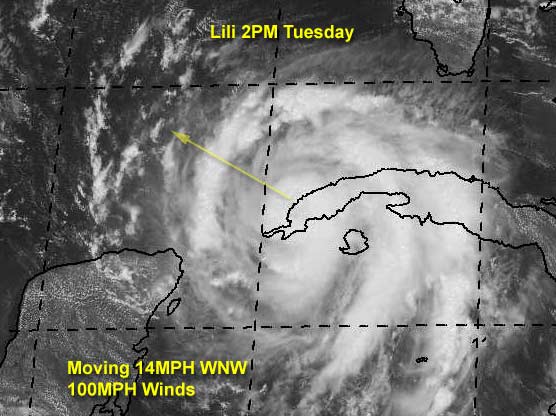
2PM Update
Lili is now a category II hurricane, and strengthening. No Yucatan to block it this time. Folks along the northern Gulf coast (especially toward Lousiana) should be watching this one closely. Note the forward speed of 14MPH. The wait won't be nearly as long as Isidore. In other words Lili is not FIzzledore.
Kyle is back from the dead again. It just doesn't want to go away.
Original Update
Hurricane Lili is nearing Cuba now, and will be moving over the western tip into the Gulf shortly. Much has not changed since yesterday. Still a potentially bad situiation in the gulf around Thursday. Upper Texas or Louisiana again.
Yesterday afternoon the site went down, but we are back up this morning, and we hope we have the situation resolved that caused the difficultly yesterday. (Grr) On the bright side, I have fixed the issue where the pop up advisories wouldn't be complete, or make the front page go missing. (Especially under stress of hurricane events)
Kyle has been downgraded to a Depression and isn't doing so well at the moment, and most likely won't restrengthen.
We'll update more as it comes in.
Havana, Cuba Radar
NRL Monterey Marine Meteorology Division Forecast Track of Active Systems (Good Forecast Track Graphic and Satellite Photos)
NASA GHCC Interactive Satellite images at:
North Atlantic Visible (Daytime Only), Infrared, Water Vapor
Some forecast models:
NGM, AVN, MRF, ETA ECMWF
DoD Weather Models (NOGAPS, AVN, MRF)
AVN, ECMWF, GFDL, MM5, NOGAPS, UKMET
Multi-model plots from WREL
Other commentary at Mike Anderson's East Coast Tropical Weather Center, Robert Lightbown/Crown Weather Tropical Update Accuweather's Joe Bastardi, Hurricane City Weather Audio Broadcast Network - Live Audio from Jim Williams and Barometer Bob , mpittweather , Tropical Weather Watchers.Com (JasonM) Gary Gray's Millennium Weather, Barometer Bob's Hurricane Hollow, Snonut, Ed Dunham and Jason M in our Storm Forum Even more on the links page.
- [mike@flhurricane.com]
| BabyCat |
| (Weather Guru) |
| Tue Oct 01 2002 01:23 PM |
|
|
Glad to see you're back, John!
This year reminds me of '98 in New Orleans. Every weekend for a month we had to prepare for a storm. Hopefully, New Orleans' luck will be the same again with no major hits.
| jth |
| (Storm Tracker) |
| Tue Oct 01 2002 01:36 PM |
|
|
The new tropical models have shifted a little east. They no longer take Lili past 93. In fact, she may not make it past 92. The A98 has her making a very ominous landfall for New Orleans and the MS coast. Look for the track to be shifted a little east by the NHC at next advisory. I will stick with my prediction of landfall within 100 miles of NO in either direction.(more likely west.)
| tom5r |
| (Weather Watcher) |
| Tue Oct 01 2002 02:04 PM |
|
|
TESTING..TESTING...IS THIS THING ON?
Its great to see this site back up and running. Lets keep our fingers crossed! I just read Bastardi's column and he seems to be sticking with Lili becoming a MAJOR storm as she races across the gulf and has her hitting somewhere west of NO.
Here in the Keys we have winds around 20 mph, some spotty showers and some sun. Pretty much the same scenario as when Izzy was in the same location. It appears thatKyle has become a memory, at least for the time being.
Tom
| usufruct |
| (Registered User) |
| Tue Oct 01 2002 02:23 PM |
|
|
If I'm not mistaken, Lilly is almost precisely where Isidore was and on about the same heading. Unusual, no?
| Frank P |
| (Veteran Storm Chaser) |
| Tue Oct 01 2002 02:38 PM |
|
|
Posted two days ago it would not be a texas storm, still think that.. ... models did shift east a little this morning and has me a little concerned, esp A98... that scenario would spell disaster for the MS coast... don't buy it yet... I still think Lili will hit west of New Orleans... within 100 miles or so... stay tuned...
Glad to see the site up and running, I was having withdrawals last night not having access.... hehe
| Unregistered User |
| (Unregistered) |
| Tue Oct 01 2002 02:46 PM |
|
|
The 11:00 am advisory says it all.
| Frank P |
| (Veteran Storm Chaser) |
| Tue Oct 01 2002 03:00 PM |
|
|
Per the nhc Lili discussion at 11:00am
<<<HOWEVER...GIVEN THE SPREAD OF THE GUIDANCE AND THE UNCERTAINTIES OF THE FORECAST NEITHER THE NEW ORLEANS OR HOUSTON/GALVESTON AREAS ARE OUT OF DANGER>>>
Track not all that sure of after 36 hours... models not consistent.... stay tuned
| JustMe |
| (Weather Guru) |
| Tue Oct 01 2002 03:16 PM |

|
|
|
Yipeee Your back
I missed last evening when the system was down
You all are wonderful and the chatter has been great..
Thanks for making the season the best
Sue
| Justin in Miami |
| (Storm Tracker) |
| Tue Oct 01 2002 03:17 PM |
|
|
It appears Kyle is mystifying the models. They have him going in every direction. Can anyone explain this? Folks in LA better get ready indeed.
| Unregistered User |
| (Unregistered) |
| Tue Oct 01 2002 03:18 PM |
|
|
I called New Iberia and I'm sticking with it. (Actually, I said Iberia/St. Mary Parishes) which are in SC-SW LA. I don't buy into the LA/TX border scenario, but obviously if Lili is heading NW at 15mph, it's not going to slow down and recurve, she's going to march. In any event, New Iberia is somewhat south of Lafayette and much closer to the coast. I don't think those guys have seen a storm in quite a while, whereas neighboring St. Mary Parish, got inundated with Andrew Part Deux.
If my landfall call was right, everyone between Lake Charles and Harrison Co. should have some effect. I think it's going to be different in New Orleans than Isidore was. For Isidore, we had 2 day rainfall totals > 20" in a large portion of the metro area. I don't see 'rainfall' flooding with Lili, but a real live shot at some serious tidal flooding cannot be ignored. Additionally, there should be massive power outages along with many more tornadoes (especially east of landfall) and much more wind.
T-60 and counting! Time to re-up the beer.
Steve
| Rich B |
| (British Meteorologist) |
| Tue Oct 01 2002 03:23 PM |
|
|
The radar data from Havana showed a well developed eye and eyewall structure as Lily approached the southwestern tip of the Isle of Youth. In fact, it seems that it is only recently as the circulation to the north of the centre interacts with Cuba itself, that the eyewall has begun to collapse. The transition across Cuba and back into the Gulf of Mexico should not take more than a few hours, so this is most likely only a temporary interruption to the system. Just found it of interest though, as this part of Cuba is relatively flat, and i did not think it would have as much effect on the Hurricane as it has.
OK, time for my predicted landfall... somewhere near Morgan City later Thursday....
Rich B
StormWarn2000
| Frank P |
| (Veteran Storm Chaser) |
| Tue Oct 01 2002 03:23 PM |
|
|
This is getting really close to my May prediction that the Big Easy was due for the BIG ONE. It might just boil down to about 75 miles or so... at least it still has some potential to come to fruition.... It's October... it's going to turn north eventually... timing is everything with this one....
Regardless, it doesn't look good for the state of LA... might just end up being the storm of the decade for someone....
| HanKFranK |
| (User) |
| Tue Oct 01 2002 03:25 PM |

|
|
|
lili: intensity forecast coming off o.k. so far.. a little low, as it were. 11pm last night had the storm at 80mph/983mb.. actual was 85mph/978mb. just now i had guessed the storm would be 85/978.. it is 90/971. staying within my 15mph/8mb margin of error so far.. barely. sticking with beaumont tx, with any corrections east.. not by much. not betting on this one really getting new orleans. it is going to cross the lowland western tip of cuba fairly soon.. some higher terrain will be just north of the center and we may see a slight weakening. as for the storm treading tainted waters, it is going right along the path isidore took.. which should begin to diverge some later today. as far as oceanic heat content, i remember the nhc guys saying isidore could move very slowly and not have to worry about upwelling due to the deep layer of warm water. my philosophy is, if isidore couldnt ruin it all, moving at about 5mph, why should lili moving at 13?
kyle has returned to tropical storm strength.. nhc had overdone the weakening.. as some uncontaminated quickscat vectors were as high as 45kt. nhc likes to underrate whenever possible, so kyle is assigned a 35kt intensity. been moving erratically this morning (a cyclonic loop).. now drifting nw in the latest frames. heavy subsedence descending from the north for another 24hr, then shear lightens and atmospheric moisture increases.. so i expect kyle to change little in the next 24, then slowly intensify and recover. with vertical depth a motion generally to the southwest should convene.
east of bermuda the part of kyle that merged into the front is an e-w elongated low pressure area... based on the convection it is generating and the fairly sharp nature of the axis at the surface i'd say it has a fair chance at development.
94L is still there, and now past the harshest shear. elongated n-s.. hard to say which part of its axis is dominant. expect this to slowly develop now, as it has survived and is on the back side of the upper trough axis.
that small rotation i mentioned yesterday 400mi east of trinidad has convection to its north now.. not well defined, but conditions aloft not wholly unfavorable. dont know what to expect here. nhc is recognizing the low but not saying one thing or another about it.
wave 500mi east of the cape verdes is now heading into 94L's shear axis. some convection with the itcz.. but no time to organize.
HF 1525z01october
| tom5r |
| (Weather Watcher) |
| Tue Oct 01 2002 03:45 PM |
|
|
Steve,
better get a keg when you re-up the beer supply. It may be a long week. I was looking at the system east of the windwards early this morning. Looked kinda ominous, following the same track as Izzy and Lili. Guess we'd better start keeping one eye out for that.
| tom5r |
| (Weather Watcher) |
| Tue Oct 01 2002 03:59 PM |
|
|
Key West long range radar shows Lili's center about halfway over western Cuba. She should be mong off to the gulf side in an hour or two.
http://www.srh.noaa.gov/radar/loop/DS.p20-r/si.kbyx.shtml
| jth |
| (Storm Tracker) |
| Tue Oct 01 2002 04:52 PM |
|
|
here is a link that you might find interesting. No storm since they began keeping records that was within 200 miles of Lili's current position in October ever made landfall west of NO.
http://www.weatherunderground.com/tropical/tracking/at200213_climo.html
| Unregistered User |
| (Unregistered) |
| Tue Oct 01 2002 04:54 PM |
|
|
But notice that's only category 1 and 2 hurricanes. I wonder if the statistics change with the inclusion of weaker or stronger storms.
-Brad
| jth |
| (Storm Tracker) |
| Tue Oct 01 2002 04:59 PM |
|
|
good question
| jth |
| (Storm Tracker) |
| Tue Oct 01 2002 05:04 PM |
|
|
check this out. Texas has never been hit by a major hurricane in October
http://www.nhc.noaa.gov/paststate.html
| Rasvar |
| (Weather Master) |
| Tue Oct 01 2002 05:12 PM |

|
|
|
Ok, I think i finally figured Kyle out. He is going to meander towards the Keys, into the Gulf and hit the La coast a week after Lili. Yeeesh. I have never seen such a meander last so long. My best wishes are with the north gulf Coast on Lili. She looks to be a nasty one.
| Frank P |
| (Veteran Storm Chaser) |
| Tue Oct 01 2002 05:37 PM |
|
|
Looking at the Key West long range radar loop it certainly appears to me that Lili is not going WNW but somewhere between WNW and NW... IMO somewhere between 305 to 310 degrees (could be just a wobble north over the time loop)... this could make a hugh difference on where she ultimately ends up, more north now, more east down the road......
I also think she is a little more north than where the models predicted her to be at this time.....
Hey, also some great climatological data posted on the board today...
| garyb |
| (Weather Guru) |
| Tue Oct 01 2002 05:42 PM |
|
|
Are my eyes playing tricks on me, or did she just take a jog to the north on the last frame of Havana, Cuba Radar.
| Frank P |
| (Veteran Storm Chaser) |
| Tue Oct 01 2002 05:46 PM |
|
|
I saw the same thing ...
| Unregistered User |
| (Unregistered) |
| Tue Oct 01 2002 05:48 PM |
|
|
Hi Folks--
as Monty Python troupe members would say- and now for something completely different!
I am looking for the above captioned---I thought it was in 54 or 55 but can't find it in the NHC archives. I have read about this storm, am looking up the track for an exercise scenario---anyone have any information?
I have seen this track before ...but now can't find...huh?
IHS,
Bill
| Unregistered User |
| (Unregistered) |
| Tue Oct 01 2002 05:49 PM |
|
|
at 1400 10/1/02....I about had the location pegged by my exam of the Vis pics...but still moving WNW...twt.
IHS,
Bill
| Unregistered User |
| (Unregistered) |
| Tue Oct 01 2002 05:50 PM |
|
|
Interesting on the Oct hurricanes. Not only has Texas not been hit, but neither have LA or AL. Wonder if folks in MS and FL need to start worrying? I think there is a first time for everything though.
| Unregistered User |
| (Unregistered) |
| Tue Oct 01 2002 05:50 PM |
|
|
| Unregistered User |
| (Unregistered) |
| Tue Oct 01 2002 05:51 PM |
|
|
FYI.
IHS,
Bill
| Unregistered User |
| (Unregistered) |
| Tue Oct 01 2002 05:52 PM |
|
|
Third try....
IHS,
Bill
| Unregistered User |
| (Unregistered) |
| Tue Oct 01 2002 05:53 PM |
|
|
Last try- 4x-
Lili is now a Cat 2 ...1400 10/1/02
IHS,
Bill
| tom5r |
| (Weather Watcher) |
| Tue Oct 01 2002 05:54 PM |
|
|
Lili's center is halfway off the cuban coast. She's stepping into the gulf as a cat 2 at 14 mph. Get ready, it's first and goal to go.
| Frank P |
| (Veteran Storm Chaser) |
| Tue Oct 01 2002 05:54 PM |
|
|
At 11:00 am Lili was at 21.8 and 83.7
at 1:00 pm she is at 22.3 and 84.4
that's a definite wobble to the NW in my book... up north 0.5 and over west 0.7.... could be just a temporary deviation off her projected course and she'll get back on that WNW track, but if she doesn't, then move the track more to the EAST... nhc still says WNW... they'll say that until she proves otherwise...
| Unregistered User |
| (Unregistered) |
| Tue Oct 01 2002 06:01 PM |
|
|
Sorry for the repeat posts, the system was not auto posting...
re: NW move...well, maybe, but if you back over the track history you will see stair stepping back and forth to the left and right of the 300 degree heading, it evens out to a tad n of wnw so far. Systems coming off a landmass often show a bit of a deviation on way of the other that smooths out.
Having said all that---I noticed as others have tha Tx has not had a major hit back to the 1880s...and Fl is the hands down target for majors...I'd say Tx is not the target anyway, La east to NW Panhandle is the range of possibilities, believe the track will switch more east with time.
IHS,
Bill
ps..and Kyle is still lurking..if he lurks past Saturday, he will head NE though....
| Unregistered User |
| (Unregistered) |
| Tue Oct 01 2002 06:12 PM |
|
|
Hi Folks--
as Monty Python troupe members would say- and now for something completely different!
I am looking for the above captioned---I thought it was in 54 or 55 but can't find it in the NHC archives. I have read about this storm, am looking up the track for an exercise scenario---anyone have any information?
I have seen this track before ...but now can't find...huh?
IHS,
Bill
| joepub1 |
| (Storm Tracker) |
| Tue Oct 01 2002 06:18 PM |
|
|
Great to see the board back up and running. I really missed the 'I think it's moving north' posts last night. Felt like I was watching all this happening all by my lonesome.
Now.....I really do agree with a couple of things I just read here. One, she sure does look like she'd done away with movement at 300 degrees. Yes, I agree that it looks much more to the NW, in fact just took a peak at 2 pm update, and that's just about right. She also just became a Cat2. WOW!
As far as being further north then the models said, that's true with the global, but the GFDL is doing a great job on the 6-12 hour marks. But it still never, ever turns Lili north until after landfall, and it seems things are going to get a little suspect in 30-36hrs. Still takes her out past 93W. And the NHC seems to have fallen back in love with it again. If I was in NO, I'd be loading the sandbags right about now. Oh, by the way, yes to the jog north over cuba. I do believe it happened.
Is anybody else wondering why with far less than 72 hrs to landfall, and a Cat 2 hurricane speeding toward the NW, why the NHC hasn't at least already put up a Hr Watch?
Kyle may well cut across the gulf and take his show to Vegas. What a strange little storm he's turned out to be. Splits himself in two. Now that looks like the kind of storm that will come over and knock my garage down for me.
Joe in Jax
| Frank P |
| (Veteran Storm Chaser) |
| Tue Oct 01 2002 06:20 PM |
|
|
Key West radar loop continues to hint of a more WNW to NW motion in lieu of the nhc stated wnw motion... best guess somewhere around 305 to 310 degrees.... I agree that interaction with land could result in a deviation from expected track and Lili could get right back on it again in the open waters... interesting point that it strengthened over land....
GFDL run is out... still to SW LA area... however, Lili is already more north and less west than she should be at this time in the model run... so throw it out as the initialization is already wrong.
| Unregistered User |
| (Unregistered) |
| Tue Oct 01 2002 06:29 PM |
|
|
Try this link....results may vary!
IHS,
Bill
http://www.srh.noaa.gov/lch/research/lchhur.htm
| Unregistered User |
| (Unregistered) |
| Tue Oct 01 2002 07:11 PM |
|
|
du-nu. du-nu. du-nu. du-nu. du-nu...
Yeah, last update per WWL TV4 is 7 over, 5 up. That's a shade closer to NW than WNW but would still be considered WNW with the overall track. People are obviously getting a bit more nervous here than they were for Izzy. General consensus is that in order to get out, you're going to have to leave sometime in the wee hours tonight! Unreal. St. Charles Parish (1 over to the west from me in Jefferson) has already cancelled school until further notice. I'd assume Orleans and Jefferson will probably do the same. I got some windows to board up tonight and some beer to purchase. I tried to talk the old lady into blowing out of town, but she wasn't biting. It seems my fascination with storms has become somewhat contageous. That's a far cry from her stark-raving-made insanity when Georges was heading this way. I guess she figures if I don't care, she don't either.
Bah. I'm drinkin' anyway.
Steve
| Unregistered User |
| (Unregistered) |
| Tue Oct 01 2002 07:19 PM |
|
|
From hpc discussions:
FL...
THERE CONTS TO BE A LOT OF UNCERTAINTIES IN THE MOVEMENT OF KYLE.
WITH THE BUILDING UPR RIDGE OFF THE SERN COAST...KYLE MAY MOVE WWD.
ATTM...THERE IS STILL A LOT OF UNCERTAINTIES. MANUAL PROGS HAVE SHOWN
ONLY SLOW WWD MOVEMENT FROM THE OFFICIAL TPC DAY 3 PSN. HOWEVER...A
FASTER WWD MOVEMENT IS POSSIBLE. SEE LATEST NHC ADVISORIES FOR
FURTHER DISCUSSIONS AND UPDATES WITH KYLE.
ORAVEC/FORECAST OPERATIONS BRANCH
| troy2 |
| (Storm Tracker) |
| Tue Oct 01 2002 07:21 PM |
|
|
Hurricane off greece?!
http://www.mindspring.com/~jbeven/medthur2.gif
some reading to go along with that...
http://www.mindspring.com/~jbeven/intr0008.htm
| troy2 |
| (Storm Tracker) |
| Tue Oct 01 2002 07:22 PM |
|
|
Hurricane off greece?!
http://www.mindspring.com/~jbeven/medthur2.gif
| troy2 |
| (Storm Tracker) |
| Tue Oct 01 2002 07:25 PM |
|
|
Bill
try here for that January storm
I think it may be the Alice strm that formed in December and lasted until Jan 5
http://www.noaanews.noaa.gov/stories/s959.htm
| Unregistered User |
| (Unregistered) |
| Tue Oct 01 2002 07:40 PM |
|
|
Thanks Troy...but when I clicked the link it went to the El Nino page, nothing about Hurricane Alice (that was the name I recalled)...was this in 1959?
Is there another link?
Thanks again!
IHS,
Bill
| HanKFranK |
| (User) |
| Tue Oct 01 2002 07:42 PM |
|
|
|
|
here's another oddball.. mentioned this before. look at the unisys archives, first storm of 1951, able. a normal near miss track near hatteras as a cat 3. then take note, the storm occurred in may.
www.weather.unisys.com
go to the archives, select 1851-2000, 1951, and able.
try 1908 as well. march of that year.
and finally, 1887. look at how much happened late in the season.
HF 1943z01october
| Unregistered User |
| (Unregistered) |
| Tue Oct 01 2002 07:43 PM |
|
|
I went back and did the word search. I remember this Alice, it formed NE of the Islands and moved SW, it is not the Miami storm.
If anyone can find it, please let me know. Meteoro-sleuthing in progress.
IHS,
Bill
| troy2 |
| (Storm Tracker) |
| Tue Oct 01 2002 07:50 PM |
|
|
Bill I did a search using January and tropical storm as well as January and Hurricane. I of course did not use Miami and Hurricane in the same search b/c of all the green and orange that would pop up
could not find it at http://www.weather.unisys.com/
either
You would thinka landfalling storm would come up before on that did not.
Maybe the Miami herald Archives or something might have that info
| VolusiaMike |
| (Weather Hobbyist) |
| Tue Oct 01 2002 07:51 PM |
|
|
|
|
I found a Hurricane Alice in the HurTrack historical database. Started 12-30-54, disapated 01-06-55, winds 81 mph, lowest pressure 1007 mb. Started just west of Lesser Antilles, moved north, then north east over the chain of islands and disappated.
If you need more, e-mail Longfellow@Ormondbeach.org
| troy2 |
| (Storm Tracker) |
| Tue Oct 01 2002 07:52 PM |
|
|
Bill on that link that i gave, please read down further under the grayed in text area with the caption "Hurricane Facts"
| Frank P |
| (Veteran Storm Chaser) |
| Tue Oct 01 2002 07:56 PM |
|
|
Best fix I could get off the vis for Lili was 22.66N and 84.84W.... motion still off to the wnw with just a hint of a northerly component... up .36 north and over west .44 from the 2:00 pm position... if my estimated position is correct... margin of error probably at least 10%....
most of the models now in good agreement and take Lili into SW or SC LA... that remains to be seen... I have not written off SE LA just quite yet by no stretch...
| Unregistered User |
| (Unregistered) |
| Tue Oct 01 2002 07:58 PM |
|
|
Thank you all for your help, apparently I came across this in a text about unusual huirricane tracks and it is so unusual it does not exist!
Back to Lili- if you take a look at latest vis sat and EYW radar, you'll see Lili has wobbled back to the west, hence 'smoothing' it's track show a pretty good 295-300 degree heading overall. This will change however, starting tonight through tomorrow (sometime in that timeframe) with a more northerly course.
Hint: look at the upper low in the west gulf on w/v .
The joker is Kyle of course.....
IHS,
Bill
| turkeyman |
| (Registered User) |
| Tue Oct 01 2002 08:02 PM |
|
|
From the calculations I've made. Lil' has moved more North as of 3pm CDT than any of the other advisories. That high building up over FL is the determinant. How strong and how far reaching it makes it is extremely important. The MS river delta magnatizes these storms for some reason. Most Gulf storms traverse the delta region like most flights out of NO go through Atlanta first. (Just a comparison of past experience). Also, doesn't the earths' rotation deal with the steering of storms North of the 25 or 26 longitude?
| Unregistered User |
| (Unregistered) |
| Tue Oct 01 2002 08:04 PM |
|
|
Bill, I see the ULL but it appears to be retrograding west in tandem with Lilli. I've been saying all along it won't go to Texas but I honestly don't see anything that will take it off this current track.
| Unregistered User |
| (Unregistered) |
| Tue Oct 01 2002 08:06 PM |
|
|
lilly looks to be moving more n/w last 3 frames what about uper low west gulf could it turn the storm more n/w
| Unregistered User |
| (Unregistered) |
| Tue Oct 01 2002 08:11 PM |
|
|
Hurricane Jerry hit Texas Oct.16 1989! 100 mph winds at coast of Galveston.
| Unregistered User |
| (Unregistered) |
| Tue Oct 01 2002 08:23 PM |
|
|
Yeah, but I believe that originated out of BOC and went due North.
| Unregistered User |
| (Unregistered) |
| Tue Oct 01 2002 08:35 PM |
|
|
I think you all just want it to go to where you're living! Well if that's the game we're playing then it's coming to Texas!
| joepub1 |
| (Storm Tracker) |
| Tue Oct 01 2002 08:46 PM |
|
|
Winds are up to 45 mph, stalled.
| Unregistered User |
| (Unregistered) |
| Tue Oct 01 2002 08:46 PM |
|
|
does anyone seem to think that the watches are a little to far west?
| Unregistered User |
| (Unregistered) |
| Tue Oct 01 2002 08:47 PM |
|
|
At 4 PM CDT...the center of Hurricane Lili was located near latitude
22.7 north...longitude 85.0 west or about 55 miles...90 km...north
of Cabo San Antonio Cuba. This is also about 600 miles...965 km...
southeast of New Orleans Louisiana.
Lili is moving toward the northwest near 15 mph...24 km/hr...and
this general motion is expected to continue for the next 24 hours.
This motion should take the center away from western Cuba and into
the open Gulf of Mexico tonight.
Maximum sustained winds are near 105 mph...165 km/hr...with higher
gusts. This makes Lili a category 2 hurricane on the Saffir-Simpson
hurricane scale. Additional strengthening is forecast during the
next 24 hours.
Steve
| jth |
| (Storm Tracker) |
| Tue Oct 01 2002 08:58 PM |
|
|
I don't think they were too far west, but I think they should have extended them a little further east. With a storm this powerful, why take chances. All of the models have Lili turning northeast either just before or immediately after landfall. Hypothetically, this turn could occur 12- 24 hours earlier than expected and poof a landfall in MS or even AL without enough time to evacuate. Poor judgment in my opinion. I grew up on the coast and I know how people are. Now that they have been basically given the all clear, they will not be prepared if a sudden change occurs.
| Unregistered User |
| (Unregistered) |
| Tue Oct 01 2002 08:58 PM |
|
|
n/w at 15 i think everything moves east will realy need to watch this what does the storm team see
| Unregistered User |
| (Unregistered) |
| Tue Oct 01 2002 09:01 PM |
|
|
Ouch! There is now a hurricane watch up for portions of the northern/western GOM coast. To be honest...I really don't give a damn where the storm is going to hit along the watch area...people in that watch area need to get ready NOW. Lili is going to be moving at a fairly good clip (14-16 knots) across the GOM. This doensn't give people much time to prepare, so they need to do it now. I'll say landfall on or just slightly east of Lake Charles, Louisiana by Thursday afternoon.
Lili intensity forecast:
Initial: 90 knots
12: 100 knots
24: 110 knots
36: 115 knots
48: 120 knots
72: 120 knots (nearing north/west GOM coast)
96: 65 knots (inland)
NOT OFFICIAL FORECAST
Kyle: Merely an issue given what it happening with Lili, but NHC is seriously underplaying this storms potential down the line. Is there a reason? Perhaps they are focusing on Lili now, which would be wise given that Kyle is still out at sea. He is slowly regenerating, the area of convection SSE of the center has persisted nicely today, and additional convection is beginning to form on the east side of the center. The center is also very-well defined, just lacking in convection for the time being. A west and southwest motion at 3-6 knots should begin tonight or tomorrow.
Kyle intensity forecast:
Initial: 40 knots
12: 40 knots
24: 45 knots
36: 50 knots
48: 55 knots
72: 55 knots
Kevin
| Kevin |
| (Weather Master) |
| Tue Oct 01 2002 09:03 PM |

|
|
|
Last post by me.
| joepub1 |
| (Storm Tracker) |
| Tue Oct 01 2002 09:19 PM |
|
|
Agreed they threw out the chance of any northward bend over the storms last 24 hrs. Seems unusual considering that a very large populated area prone to flooding from hurricanes, and extremly hard to clear the people out of, won't be passed until the last day(24 hrs) before landfall, even by their own math. What a risk! Don't even want to imagine a Cat3 doing an Izzy move at the last moment on New Orleans. Who's going to listen to a TS warning?
From the 5pm diss.
THIS PATTERN SHOULD KEEP LILI ON A GENERAL NORTHWESTWARD OR WEST-NORTHWESTWARD TRACK THROUGH 36-48 HR...FOLLOWED BY A GRADUAL TURN TO THE NORTHWEST AND NORTH. NHC TRACK GUIDANCE IS IN STRONG AGREEMENT WITH THIS SCENARIO...WITH THE CONSENSUS OF THE MODEL GUIDANCE CALLING FOR LANDFALL IN SOUTHWESTERN/SOUTH CENTRAL LOUISIANA IN ABOUT 48 HR.
South-central Louisiana? Then why not include New Orleans?
Like I said above: WHAT A RISK
Joe in Jax
| Unregistered User |
| (Unregistered) |
| Tue Oct 01 2002 09:25 PM |
|
|
They did include Houston/Galveston to New Orleans further down the Discussion.
| Unregistered User |
| (Unregistered) |
| Tue Oct 01 2002 09:25 PM |
|
|
As we all know, the bigger the storm, the more forward momenutum it has and less chance of a radical turn. It's been stair-stepping it's way between NW and WNW for a couple of days as the center rotates within the overal hurricane. I think the TPC is playing this out as having less chance to turn toward the end (except gradually). If this is the case, Golden Triangle to Lake Charles - LOOK OUT! That's Orange, TX, Sulphur, LA, Lake Charles, LA, Westlake, LA, Cameron, LA, Hackberry, LA, Port Arthur, TX, Beaumont, TX.
I want to see where the 10pm (CDT) forecaster goes with this. As we've seen all day, the models have trended east, yet the official track has definitely backed off west. This is an interesting play. Let's see how it plays out, because NHC's ass is on the line with a major hurricane heading toward the coast within 48 hours!
Whew.
Steve
| Unregistered User |
| (Unregistered) |
| Tue Oct 01 2002 09:28 PM |
|
|
Is that they're going to wait for more model data to make a real call and nudged the track a hair west so that no one on the Upper TX Coast relaxes.
Steve
| tom5r |
| (Weather Watcher) |
| Tue Oct 01 2002 09:36 PM |
|
|
I honestly have no idea what'a going on in the New Orleans area but I would just guess that an advisory will be given for a voluntary evacuation early tomorrow morning. That should buy a little time to watch Lili's track for a little longer and make a final decision.
| Unregistered User |
| (Unregistered) |
| Tue Oct 01 2002 09:57 PM |
|
|
Just got an email from a friend in New Orleans. She said that they have been told that the storm will make landfall west of N.O. People in low lying areas are being advised to leave.
Her family has made hotel reservations out of town just in case.
| joepub1 |
| (Storm Tracker) |
| Tue Oct 01 2002 10:04 PM |
|
|
>>They did include Houston/Galveston to New Orleans further down the Discussion.<<
Yes, they did, and they have for the last day or so. But don't you really think that the discussion is aimed at the local forecasters, who put out the information to the pubic? Trust me, there are people who don't even know there's a storm coming yet. 1 person in __,000 has read a NHC discussion.
My point is this: put up a hurricane watch, go 12 to 24 hrs, then drop it to a TS warning when your'e etched-in-stone sure that you have it right. That's still a full day out, and would make the people in the warning area take it that much more to heart if they felt that the NHC was that sure of the landfall.
My real hope is that the NHC has this thing pinned down as much as they would make me think. I would hate to see them be wrong, because we're not talking a what-if deal (what-if Izzy had made landfall as a Cat3), we're talking the real thing now.
| Southern4sure |
| (Weather Guru) |
| Tue Oct 01 2002 10:09 PM |

|
|
|
of Lili ending up further east than expected? That is what Im afraid of.
| Unregistered User |
| (Unregistered) |
| Tue Oct 01 2002 10:12 PM |
|
|
Agree, Steve.
Don't think anyone can afford to relax along that coast.
| Unregistered User |
| (Unregistered) |
| Tue Oct 01 2002 10:30 PM |
|
|
I agree 100% joepub... New Orleans should be under a hurricane watch, not tropical storm watch... back in 1998 Georges was making a bee line to NO... they evacuated... but at the last minute it went inland on the MS coast... which was not anticipated by anyone... same thing could happen here.. probably not, but why not be safe in mean time....
nhc must be REALLY confident on its track... also Lili is growing is size, her cloud base covers about 700 miles right now...
Frank P
| Unregistered User |
| (Unregistered) |
| Tue Oct 01 2002 11:05 PM |
|
|
you central gulf coasters are really harping on this thing turning north and hitting new orleans or something. as if you havent had enough fun this year. youd need a pretty doggone weak ridge to get that to happen.. i just dont see it. the hurricane is pumping it up, and a trough is locked in the western US.. nothing in the atmosphere is indicating the ridge should weaken. the models taking it further east are the statistical leaning ones.. which know an east-west ridge this time of year along the northern gulf coast usually wont extend as far west or as strong. but it is, in fact, building its influence westward thanks to lili. staying with beaumont/port arthur, or maybe just east of there in cameron parish landfall. as far east as i can conceive it coming is atchafalaya bay/morgan city. think galveston/houston is too far west.. left side of the storm and shouldnt see much.
so far my intensity track is too low. fresh after isidore i'm ready to play it cautious on that note. the 140mph hurricane i have at landfall is pretty fierce.. and closer than expected at this point. if that official forecasted 120mph 'cane comes in count it a blessing. landfall best guess is thursday late afternoon. if i was in new iberia, jennings, crowley, lake charles.. over to the sabine pass area.. i'd be getting everything ready ASAP.
HF 2258z01october
for all you armchair quarterbacks out there who like to stay on topic:
go bengals, 2002 super bowl champs.
| Unregistered User |
| (Unregistered) |
| Tue Oct 01 2002 11:57 PM |
|
|
Reviewing the latest IR loop Lili certainly looks to be jogging to the west right now, or just north of due west..... doesn't have that defined NW motion as it did earlier in the afternoon, not to me at least... West is best from a MS standpoint...
Boy this thing is really cranked up on IR... somebody is going to get pounded... hard....
| joepub1 |
| (Storm Tracker) |
| Wed Oct 02 2002 12:09 AM |
|
|
>>Lili certainly looks to be jogging to the west right now<<
Don't tell anybody in the Yucatan that.....
| Frank P |
| (Veteran Storm Chaser) |
| Wed Oct 02 2002 12:22 AM |
|
|
I guess its going to wobble between wnw and nw during the next 24 hours or so... Lili has been well behaved thus far with little surprises... I guess we are due a monster storm with some manners... but you got to feel for who ever gets this beast... cause it is going to be their storm of the decade...
Looking at the latest GOES IR I have it estimated at 23.14N and 85.74W at 23:31 UTC
| Unregistered User |
| (Unregistered) |
| Wed Oct 02 2002 12:24 AM |
|
|
Hey Frank P, my comfort level is slowly decreasing over here. I'm hoping for no further west than Beaumont, but looks like she's moving more west than northwest right now. Need my electricity for the big game Saturday
| Unregistered User |
| (Unregistered) |
| Wed Oct 02 2002 12:25 AM |
|
|
east gulf clear on this one thank you this will be texas l/a line be safe east gulf no wish cast we dont need this one watchs may go more west
| WXMAN RICHIE |
| (Weather Master) |
| Wed Oct 02 2002 12:38 AM |

|
|
|
The streak of the USA not going to be hit by a hurricane for 3 straight years is about to end, just as it did EVERY other time. This time it's going to be the real deal too.
| Unregistered User |
| (Unregistered) |
| Wed Oct 02 2002 12:48 AM |
|
|
if the storm keeps moving westand not n/w when it makes the turn north it will have more gulf to cross and just what if it has more time to turn north east just a look when do the new models run great job guys be safe
| joepub1 |
| (Storm Tracker) |
| Wed Oct 02 2002 12:51 AM |
|
|
Houstontracker,here's a note of hope.
Just looked at the 18Z GFDL. It started out with the 2 pm plot:22.4N, 84.4W. It said in six hours Lili would be at 22.9N, 85.7W. The 8PM update puts her at 23.0N, 85.6 W. That's real close, almost perfect in fact, and it still does not take it any further west than 93.5. So for the moment you could look at that for comfort.
Now when Frank P. reads that he will most likely be laughing his a%$ off, because my feelings about the GFDL have been made known on this board. I'm using the GFDL has a guide? A littlr further up I did say how well it was doing on the short range. Long range, we'll see.
I'm not taking it out of the Axis of Evil just yet.
| Frank P |
| (Veteran Storm Chaser) |
| Wed Oct 02 2002 12:54 AM |
|
|
Yeah HT, if I was you I think my comfort level would not be all that good right now either... chances are however you should probably be on the west side of the system, if that is any comfort... still with a Cat 3 no side is a good side if you are in the eye wall...
that being said, I have been tracking the center on IR for the past 45 minutes and it appears IMO to be back on the NW track as best I can determine.. wobble NW then back WNW willl be the SOP for Lili... I have it at 23.22N and 85.84W at 00:15 UTC (estimated at best)
Rebels got a Cat 3 Gator team to deal with this weekend too... Good Luck, Rebs gonna need it...
| joepub1 |
| (Storm Tracker) |
| Wed Oct 02 2002 01:02 AM |
|
|
I'm not sure the Gators are up to Cat3 quite yet. Looked more like a weak Cat2 against Kentucky. I hope they got all the blocked punts, missed extra points,ect out of their system last week.
Jags face Philly this week. Now that's gonna take some luck..................................
| Frank P |
| (Veteran Storm Chaser) |
| Wed Oct 02 2002 01:03 AM |
|
|
Hey, do you have stock in GFDL???
Y'know, every now and then some of the models do a decent job, especially with a moving system.... GFDL did a good job on the track with Edouardo, but blew the intensity big time...Maybe GFDL has Lili right on target... MAYBE..
Hey my opinion on models..... if they don't have legs, I don't want em... hehe
Models are like Casinos... you find one you like and stick with it till it burns you.. cause they all do eventually... at least we'll still have them around on the coast this weekend.... because if Lili hit here they'd be all destroyed...
| Steve |
| (Senior Storm Chaser) |
| Wed Oct 02 2002 01:16 AM |

|
|
|
HF - for the record, I'm sticking with my Iberia Parish/St. Mary Parish landfall call. That's further east than what they're reporting here on the news except that Iberia Parish was one of the first to announce actions. Perhaps those officials must read flhurricane.com, best forum on the web. I hope your intensity forecast is on the aggressive side, but I kind of get the feeling you think it's achievable. You've convinced me. Cat 4 seemed strong, but if Lili hits Cat-3 tonight, uh, I dunno man - there's 500 miles of Gulf ahead...
Richie - This is definitely the storm of the decade for whomever takes the hit. Local mets aren't even questioning that it's easy Cat-3. Mayor Nagin came on tv a few minutes ago and said that everyone in N.O. should immediately review all plans and get your stuff together. They also want everyone packed in case they tell us to roll out. There have been some rumors, and I guess the thing is, you have to be ready if there's a quick call to action as we already don't have enough time to evacuate the whole city. Fuggetabahdit.
Landfall destination determines what we see here in the City, but we could face extremely dangerous conditions being on the east side. How far east has a lot to do with it. I boarded up a couple of windows in my bedroom just in case. My biggest fear right now is the aspect of tornadoes in Metairie/New Orleans. But the further sw she passes the city, the easier we'll be breathing. She's got about 4.4 more degrees to bypass me to the south.
Good luck to everyone out there. I'm going to try to post, but I got a bunch of stuff to take care of for now. If they call a mandatory we probably need to get the kids out of town. So if I can't get back for a while after tonight or early morning, y'all take care.
Steve
| Justin in Miami |
| (Storm Tracker) |
| Wed Oct 02 2002 01:26 AM |
|
|
Just Curious....How many evacuation routes are there out of New Orleans? How long does it take to evacuate everyone for a Cat 3? Are there any shelters or refuges of last resort in the City? I would hate to be the New Orleans Emergency Manager right now.
| Southern4sure |
| (Weather Guru) |
| Wed Oct 02 2002 01:28 AM |
|
|
|
|
NWHHC continues to recommend a hurricane watch from Galveston, Texas through Pensacola, Florida. Please refer to local emergency management officials for any official watches and warnings.
Currently, the eye of dangerous Hurricane Lili is located near 23.0N and 85.6W. This places the eye about 560 miles SE of New Orleans, Louisiana. The current motion is to the WNW near 15 m.p.h. A turn back to the NW at an increasing forward speed is expected during the next few days. Landfall is expected to be in Louisiana on Thursday.
Maximum winds have increased to 110 m.p.h. The pressure is 968mb. Rapid to explosive intensification is now expected and Lili should make landfall as a category 4 hurricane with winds of 135 to 140 m.p.h.
| Unregistered User |
| (Unregistered) |
| Wed Oct 02 2002 01:47 AM |
|
|
Where did you get this post?
| Steve |
| (Senior Storm Chaser) |
| Wed Oct 02 2002 01:51 AM |
|
|
|
|
It takes 72 hours to fully evacuate GNO. Clearly we don't have that kind of time. There aren't many ways out the whole area - much less the city. There's I-10 to the east. You could catch that to the I-59 and head north (Hattiesburg) or continue east to I-65 in Mobile and head north. You can take the I-10 west to the I-55 (Hammond) and head north there. You could go further west to Lafayette and take the I-49 north there. You can go north on the Causeway and then go either east or west. There are some rural roads, but it's pretty limited.
I gotta go take care of some stuff. L8R,
Steve
| Unregistered User |
| (Unregistered) |
| Wed Oct 02 2002 01:52 AM |
|
|
yea i am in pensacola an i though i was out in the clear? is there something i dont know?
| tom5r |
| (Weather Watcher) |
| Wed Oct 02 2002 01:55 AM |
|
|
Hey Southern, where DID you get that post?
| BillD |
| (User) |
| Wed Oct 02 2002 02:06 AM |
|
|
Southern got that info from another unofficial hurricane site http://www.nwhhc.com
Bill
| joepub1 |
| (Storm Tracker) |
| Wed Oct 02 2002 02:07 AM |
|
|
Go to this site for local coverage, including NWS radio.
http://www.nola.com
| HanKFranK |
| (User) |
| Wed Oct 02 2002 02:15 AM |
|
|
|
|
lili's appearance has improved dramatically since this morning. eye is now well cut, cdo a more circular ring. its really hard to predict how strong these things will get.. think this may max offshore as ssts will drop slightly near landfall. of course the bastardi gradient crunch effect could counter this or overrule it. will see.
the way i figure it, lili is dropping 20mb every 24hr. assume early landfall and put the storm in in 36 (thursday late morning).. and the storm is 30mb deeper.. 938mb at the overall rate of deepening. now consider.. lili is crossing the open gulf and will not have to contend with land.. and will probably get closer to 42hrs over the ocean... this could be a very mature hurricane.
kyle is my other note. still partially exposed low level center but much improved appearance since this morning, as with lili. convection is now almost half way around the llc.. should slowly intensify and begin to crawl westward under the ridge by tomorrow. so i think.
94L.. sputtering, maybe still going to try something.
nothing else looks any good tonight in the basin.. but with lili its not like anyone notices that.
by the way, steve, got my road atlas out and studied the louisiana coastline. i think youre too far east. but then again im probably too far west. though i'm not changing my beaumont take, lili may well come in between... cameron or vemillion parish. not much in the way of populace down there.. im sure they know to get out of the bayou when one of these babies comes roaring up out of the gulf.
beaumont, lake charles, lafayette.. one of these cities stands to take considerable damage from this storm.
HF 0209z02october
| joepub1 |
| (Storm Tracker) |
| Wed Oct 02 2002 02:26 AM |
|
|
There will be no official emergency shelters opened in Southwest Louisiana if Hurricane Lili makes landfall near here Thursday.
That's according to Dick Gremillion, director of the Calcasieu Parish Office of Emergency Preparedness.
"Due to funding and the fact that shelters here are in flood zones, the Red Cross and Federal Emergency Management Agency have decided not to open any in our parish or anywhere else along the Gulf coast,"
This is going to be bad, folks. They said they might open them as a last resort, but there will be no supplies of any kind. Over 180,000 live in the Lake Charles area, which lies between 93 and 94W, the area expected to take a direct hit at this time. Hopefully, these people will just plain get out of town for a couple of days.
| Justin in Miami |
| (Storm Tracker) |
| Wed Oct 02 2002 02:28 AM |
|
|
Hank what is your take on Kyle? Listening to the media one would think it is of no concern for FL.
| WXMAN RICHIE |
| (Weather Master) |
| Wed Oct 02 2002 02:32 AM |
|
|
|
|
Pressure down to 966 mb, winds sustained 105 mph with gusts to 125 mph, 23.3 N 86.3W, moving faster at 16 mph WNW. WATCH OUT!!!
| LoisCane |
| (Veteran Storm Chaser) |
| Wed Oct 02 2002 02:41 AM |

|
|
|
Just watching an intense storm that u know is going to hit land somewhere.... inevitable can't stop it..just watch.. reminds me so much of that evening with a strong small stom with a well defined eye racing towards its target
| Justin in Miami |
| (Storm Tracker) |
| Wed Oct 02 2002 02:50 AM |
|
|
I am thinking the same Lois. When Andrew was coming...all you could do is watch and watch and then listen. It is a very surreal feeling just before a storm like that hits.
| Unregistered User |
| (Unregistered) |
| Wed Oct 02 2002 02:51 AM |
|
|
Ya It is really starting to take shape , I say it will go a little furher to the east possible buras , nawlins landfall by the time it is all said and done. Frank P. & Steve hope you guys are set for the big blow , as lili is fixin to jump out of the BIG POND ! You guys keep us updated here, and be SAFE !!
| tom5r |
| (Weather Watcher) |
| Wed Oct 02 2002 02:51 AM |
|
|
Lil is looking like a buzz saw. She'll be cutting new highways someplace. Kyle has been creeping around slowly and quietly for some time now, like a predator waiting for the right moment to strike. Gotta watch him.
| Southern4sure |
| (Weather Guru) |
| Wed Oct 02 2002 02:57 AM |
|
|
|
|
sorry for the delay, but my puter crashed and then I was on the phone for awhile.
Bill, that was the address where I saw that info. I thought the info. was official, not the site.
Southern
| Unregistered User |
| (Unregistered) |
| Wed Oct 02 2002 02:59 AM |
|
|
There is a reason why I have been silent and that is because of fear. I do have a question about the NHC's forecasted track,though. They seem to be pushing the track a little further east and yet she has picked up speed and is now going WNW. First of all, isn't Lilly moving too fast to make that sharp of a turn? I don't see anything that states that she will slow down,either. I could see her taking a turn like that if she were to slow down, but that is not being forecasted. Also, her picking up speed would lead me to believe that maybe it would be that much closer to land before it would even try and take a turn which would put places a little further west at more of a risk. This is in NO means a way of wishcasting; I'm asking these questions because I need to know if I should start making plans.
ShawnS
| Southern4sure |
| (Weather Guru) |
| Wed Oct 02 2002 03:02 AM |
|
|
|
|
curiosity question, if that wasnt real, then who is forecaster Ortt?
| BillD |
| (User) |
| Wed Oct 02 2002 03:07 AM |
|
|
Me too, I've been thinking about that since Lili cleared Cuba. I still remember early Sunday morning before Andrew, a bunch of my buddies and I had been partying all night on Miami Beach and about six of us crashed in a hotel room. I woke them all up about 6:00am and told them we were leaving, they thought I was crazy, until they really looked at what was on the TV. It was like a dream, did not even seem real, but no question that Andrew was on a beeline for us.
If I were in the hurricane watch area I'd already be boarded up, stocked up, and ready to get out of there.
Someone is going to get hit hard with this one.
Bill
| Mary K. |
| (Weather Guru) |
| Wed Oct 02 2002 03:07 AM |
|
|
Even if you are not in the direct path of that hurricane, you will need to be prepared for tornados rain and wind damage. Possible loss of electricity either because of direct hit or because some one skids into a power pole because of rain. Being prepared will reduce anxiety some. The storm going some place else will help the most.
| joepub1 |
| (Storm Tracker) |
| Wed Oct 02 2002 03:11 AM |
|
|
Forecast aiming for SW LA, Pecan Island and a place called the Rockefeller State Wildlife Refuge and Game Preserve. Abbeville, the city of Lafayette, and the town of Gueydan are also in that area as well.
| Unregistered User |
| (Unregistered) |
| Wed Oct 02 2002 03:17 AM |
|
|
looks like a buzz-saw to me....any chance ya'll...that this killer could defy the computer's and hit New Orleans?....
Shawn...you better prepare...quick...
this one looks ominous...don't want to put fear in anyone...but I agree with the assessment of an Andrew-type storm. This will be a bad one...
| BillD |
| (User) |
| Wed Oct 02 2002 03:25 AM |
|
|
Southern, this is what I captured from the message board linked from that site. I am assuming this is "Forecaster Ortt".
Welcome to Cyclonic Weather Talk! This is a new message board created and maintained by three indepenedent tropical weather forecasters:
Rob Mann HurricaneWorks.Com
Jason Moreland TropicalWeatherWatchers
Derek Ortt Northwest Hemisphere Hurricane Center
| troy2 |
| (Storm Tracker) |
| Wed Oct 02 2002 03:25 AM |
|
|
TCUAT
BULLETIN
TROPICAL STORM LILI TROPICAL CYCLONE UPDATE
NATIONAL WEATHER SERVICE MIAMI FL
1005 PM CDT TUE OCT 1 2002
THIS IS TO UPDATE THE CENTRAL PRESSURE OF HURRICANE LILI.
THE LATEST INFORMATION RECEIVED FROM AN AIR FORCE RESERVE
RECONNSISSANCE AIRCRAFT AT 942 PM CDT...0242Z...INDICATES
THAT THE CENTRAL PRESSURE OF LILI HAS DECREASED TO 963 MB...
OR 28.44 INCHES.
FORECASTER STEWART
| Justin in Miami |
| (Storm Tracker) |
| Wed Oct 02 2002 03:27 AM |
|
|
Does anyone know if there are petro chemical plants or facilities in this area of SW LA? Looking at a map, and this area looks VERY rural...except for some spoty development along the coast. I would regret owning beach front property in Cameron Parish, LA. Hopefully the folks that live there are not there on Thursday!
| joepub1 |
| (Storm Tracker) |
| Wed Oct 02 2002 03:40 AM |
|
|
Justin, you must be looking at the same map I was. The 2000 census doesn't even refer to a place call Pecan Island, and I couldn't find any townships or cities except the one's I listed in a prior post. Even those are somewhat inland, but I'm sure it's flat as can be, if not already under water(swamp). Looks like a huge wildlife preserve to me, but I've never been there so I can't say.
Buy the way, me and you need to watch our backs(Kyle).
| Unregistered User |
| (Unregistered) |
| Wed Oct 02 2002 03:50 AM |
|
|
THE NHC MODEL
GUIDANCE REMAINS VERY TIGHTLY PACKED AND STRONGLY AGREE ON A
LANDFALL OVER SOUTH CENTRAL OR SOUTHWEST LOUISIANA IN ABOUT 42
HOURS. OF COURSE... JUST A SLIGHT WOBBLE TO THE WEST WOULD BRING THE
CENTER OF LILI CLOSER TO THE HOUSTON-GALVESTON AREA...AND A WOBBLE
TO THE EAST WOULD TAKE THE POWERFUL HURRICANE CLOSER TO THE NEW
ORLEANS AREA.
THE OUTFLOW PATTERN CONTINUES TO EXPAND AND IMPROVE...WHILE THE
INNER CORE CONVECTION AND THE EYE CONTINUE TO BECOME BETTER DEFINED.
LILI ALREADY HAS THE APPEARANCE OF A MAJOR HURRICANE AND NOW THAT
THE EYEWALL HAS DECREASED FROM 35 NMI DOWN TO 17 NMI... SOME
SIGNIFICANT DEEPENING IS LIKELY TO BEGIN SHORTLY AND CONTINUE FOR
ANOTHER 12 TO 24 HOURS. IT IS POSSIBLE AND EVEN PROBABLE THAT LILI
COULD RAPIDLY INTENSIFY AND PEAK AT AROUND 110 KT BETWEEN THE 12 AND
24 HOURS TIME PERIODS...AND THEN WEAKEN SLIGHTLY AFTER THAT. THIS
INTENSITY SCENARIO WILL BE CLOSELY ASSESSED ON THE NEXT ADVISORY.
UNFORTUNATELY...IT LOOKS LIKE LILI WILL BE A MAJOR HURRICANE WHEN IT
MAKES LANDFALL.
| Domino |
| (Weather Guru) |
| Wed Oct 02 2002 03:59 AM |
|
|
Well about a week ago when everyone was going bonkers over Izzy I was going on about Lili...had no clue what it would bring us, but it just "felt right" back then. I feel for you all down south. This is gonna be a biggie.
| Unregistered User |
| (Unregistered) |
| Wed Oct 02 2002 04:07 AM |
|
|
we all know Andrew was a cat 5 now...interestingly...there are rumors that many more died than the government allowed. Here is the scoop from a friend I know who went down there....and helped...
many victims were nursery workers...illegal aliens...he said there were stacks of bodies....and the government only admitted to American deaths....
I mention this for this reason...no matter what the government tells us..this thing is gonna be bad...and guess who takes it on the chin?...the poor and underprivileged.
I am not trying to start a debate on this....but he knew first hand that the morgues were all packed and stacked....with the dead...
and yet the official count was under 20.
remember..this hurricane had 210 mph winds....it broke guages that read that high....
| BillD |
| (User) |
| Wed Oct 02 2002 04:53 AM |
|
|
Rickinmobile, I have to say that I fnd it hard to believe what you are saying. I rode out Andrew, and had friends and family in Cutler Ridge and Homestead. The destruction was beyond description, my brother's motherinlaw, her mother and daughter rode out the storm in the Naranja Lakes condos where at least three people died. Concrete block structures were reduced to piles of rubble. I also knew people in the Redland (farming areas west of Homestead) we went to check on them. We saw miles of concrete power poles snapped off about 10 ft high, and acres and acres of hundred year old pines the same. Thousands of acres of mango, avocado, citrus, papaya and other crops were literally flattened, nothing was left standing. So anything is possible, but I've never heard anything about "illegals" being killed and nobody paying attention. There is and has been a very active support structure for migrant farm workers for many years. It is hard to believe that "stacks" of them disappeared and nobody said anything. But at the same time, the whole south end of the county was taken over by the military. You didn't go anywhere without passing through National Guard checkpoints, and other military were dispatched across the entire area. Believe me when I say it is not something that you want to have to deal with.
Bill
| HanKFranK |
| (User) |
| Wed Oct 02 2002 05:19 AM |
|
|
|
|
rickinmobile. you been watching the x-files a little too much? come on man.. name one good reason the government had its CIA g-men stacking grapefruit pickers into morgues. is this a normal priority, when youve got 300000 homeless persons? we're these illegal aliens in fact extraterrestrials? maybe you should just stick to calling that cat 5 to mobile (only 211 years, 11 months, 17 days to go, statistically speaking). seriously man.. you were kidding about the conspiracy...? right?
lili has the classic major hurricane appearance now. i'd expect we'll have a cat 3 before daybreak wednesday. im still not sure why nhc only brings it up to 105kt, and mentions that it may briefly peak at 110kt. you extrapolate out the rate of deepening, of which i see no reason to discount that it will continue.. and youre down below 940mb at landfall. now correct me if i'm wrong, but under 945 usually signifies a category four.
well, my intensity track is already ruined thanks to how quickly the storm has deepened. i wouldnt be surprised now if the storm reaches four tomorrow and peaks closer to five.
by the way, has everyone forgotten 94L. quite a bit of convection on that fish spinner out there.. and various modeling has stuff trying to go out in the central atlantic by the weekend.
marco... coming soon? one thing's for sure.. the truth is out there.
HF 0517z02october
| HanKFranK |
| (User) |
| Wed Oct 02 2002 05:53 AM |
|
|
|
|
958mb. eye presentation is good. max FL wind 97kt, outbound NE wind at 107kt. pressure has fallen 13mb in about as many hours.. but 10mb in the last six or so.
HF 0555z02october
| Domino |
| (Weather Guru) |
| Wed Oct 02 2002 07:51 AM |
|
|
Down to 954 MB in the last vortex message...looks like she will be a cat 3 for the 5am advisory. At this rate and without any changes, I really have a tough time understanding why she won't be a Cat 4 by landfall. Yes, the water is a bit cooler in the north, but she's not slowed down yet.
| Unregistered User |
| (Unregistered) |
| Wed Oct 02 2002 11:33 AM |
|
|
conspiracy shmiracy. I love it when someone throws out something...and the first thing people do is categorize them as conspiracy freaks, as though the government in any and all situations is above board. wake up hank frank, and re-read my post, and the one after it. I am only parroting what I heard.
now, to Lili
sure looks like a New Orleans possible hit to me
| Hurric |
| (Weather Guru) |
| Wed Oct 02 2002 12:36 PM |

|
|
|
Rick, Please, now is not a good time to be playing this game. I tried to respond immediately last nite to your,"Stacked bodies" post but couldnt logon.
In the first two weeks after Andrew all kinds of rumers were rampant concerning deaths from Andrew, People were scared, confused and information sources were limited. It has been ten years.
Relize that some people get off on either repeating or starting rumers. Something inside makes them feel important that they know something others don't. This is at best a character flaw. It is well known that eyewitness reports can be seriously flawed.
If you dont want to be looked at as a conspiracy freak then dont act like one. Especially at this time when so many people need to focus on what is happening with Lili.
Hurric
| Unregistered User |
| (Unregistered) |
| Wed Oct 02 2002 12:40 PM |
|
|
Rickinmobile/HankFrank
Here is a link you both might find interesting, about the "Hurricane Andrew Cover-up" Thought the 350+ winds was "interesting". Rickinmobile, maybe your friend was refering to this article. Just thought both of you, and other posters, might enjoy the article.
http://wwwnexusmagazine.com/hurricane.html
| troy2 |
| (Storm Tracker) |
| Wed Oct 02 2002 01:01 PM |
|
|
http://www.nexusmagazine.com/hurricane.html
ya left out a dot.
| troy2 |
| (Storm Tracker) |
| Wed Oct 02 2002 01:16 PM |
|
|
overall its a garbage story, what one would fing in the pages of the Weekly World News or "G-Men will Get You" magazine.
A 5 degree jump as he stated the EBS statement mentioned would be the distance rougly from Homestead to Jax. And it didnt happen within 5 minutes.
I can go on and on dismantling the semantics of that garbage story but will let evryone else read the story first to develop their own views.
| jth |
| (Storm Tracker) |
| Wed Oct 02 2002 01:23 PM |
|
|
That is one of the most idiotic things I have ever read. If you believe any of that, then I have some....... you know how it goes. "it changed 5 degrees at the last minute and within seconds was upon us yeah right.
| Unregistered User |
| (Unregistered) |
| Wed Oct 02 2002 01:30 PM |
|
|
troy2
First, thanks for remiinding me abot the "dot" .
Second, I agree with you 100% about the article being gabage. I just posted the link so you and others could read it. Seems like science fiction to me !!!!!!
Tony
| Unregistered User |
| (Unregistered) |
| Wed Oct 02 2002 01:32 PM |
|
|
BUT IT MUST BE TRUE......IT'S ON THE INTERNET!!!!
| Unregistered User |
| (Unregistered) |
| Wed Oct 02 2002 01:37 PM |
|
|
jth,
Agree with you also, it is the most idiotic thing I have also read. No, I NEVER believed any of the article, as I said in my previous post, I just supplied the link to this site so others might see it.
Tony