CFHC
|
| () |
| Fri Oct 25 2002 01:24 PM |

|
|
|
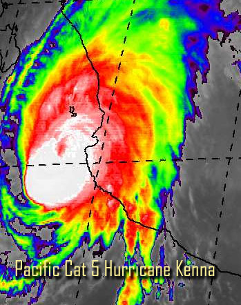
Category 5 eastern Pacific Hurricane Kenna, very impressive earlier, is landfalling on the western mexican coast. It's moving fairly quickly toward it.
We wish the best of luck to those who hopefully prepared on the Mexican West coast.
In the Atlantic, we've got some disturbed weather in the southwest caribbean. I don't expect any more development this month, it's still possible, but I don't expect it.
NRL Monterey Marine Meteorology Division Forecast Track of Active Systems (Good Forecast Track Graphic and Satellite Photos)
NASA GHCC Interactive Satellite images at:
North Atlantic Visible (Daytime Only), Infrared, Water Vapor
Some forecast models:
NGM, AVN, MRF, ETA ECMWF
DoD Weather Models (NOGAPS, AVN, MRF)
AVN, ECMWF, GFDL, MM5, NOGAPS, UKMET
Multi-model plots from WREL
Other commentary at Mike Anderson's East Coast Tropical Weather Center, Robert Lightbown/Crown Weather Tropical Update Accuweather's Joe Bastardi, Hurricane City Weather Audio Broadcast Network - Live Audio from Jim Williams and Barometer Bob , mpittweather , Tropical Weather Watchers.Com (JasonM) Gary Gray's Millennium Weather, Barometer Bob's Hurricane Hollow, Snonut, Ed Dunham and Jason M in our Storm Forum Even more on the links page.
- [mike@flhurricane.com]
| troy2 |
| (Storm Tracker) |
| Fri Oct 25 2002 01:52 PM |
|
|
wow 165 mph. Crazy!
| Unregistered User |
| (Unregistered) |
| Fri Oct 25 2002 04:32 PM |
|
|
I know, it's not fair/it's not fair. Why should Louisiana get all the action! Looks like by Monday I'll be upping my rainfall as direct result of tropical activity count to 7. That's absolutely unheard of, but I'll take it
Steve-unplugged
| HanKFranK |
| (User) |
| Fri Oct 25 2002 05:21 PM |

|
|
|
dont usually see the eastpac this active so late in the season. theirs begins before ours, but usually ends before as well. kenna is coming ashore probably in the cat 3-4 range right now between cabo corrientes and matazlan.. moving faster, should be up around south texas by tomorrow afternoon.. as a sheared out remnant.
lowell pathetic looking and getting kinda close to hawaii. another centpac depression south of hawaii, maybe a storm later on.
then in between lowell and kenna there's another invest that looks good to go. M storm.. pacific getting ahead of the atlantic after losing its pace in late september.
HF 1717z25october
| BabyCat |
| (Weather Guru) |
| Sat Oct 26 2002 02:49 PM |
|
|
http://story.news.yahoo.com/news?tmpl=story2&cid=535&ncid=535&e=3&u=/ap/20021026/ap_on_re_la_am_ca/mexico_hurricane_kenna_5
This is a link to a slideshow of Kenna damage.
| Unregistered User |
| (Unregistered) |
| Sat Oct 26 2002 08:17 PM |
|
|
Take a look at the brownsville radar - could Kenna be reforming?
| HanKFranK |
| (User) |
| Tue Oct 29 2002 05:53 AM |
|
|
|
|
month is almost over, and while two september storms lingered into this month, no named storm has formed in the atlantic during october. the last time a named storm failed to form in october was 1994. just for reference, the last named storm of the season so far is lili, and it formed september 21st. 1993's last storm, harvey, formed september 18th.. so this is not unprecedented, but rather uncommon. especially in light of the fact there have been 12 named storms so far in 2002. will november bring us another? hard to say.. though my gut feeling is no.
HF 0437z29october
| Unregistered User |
| (Unregistered) |
| Tue Oct 29 2002 12:12 PM |
|
|
Maybe a stormless October, but check out the area NW of Columbia in the western Caribbean. Looks real good on sat pix this morning, but I'd like to see the visibles. Seems to show the earmarks of a low developing. With the hot weather we've had, think one more is in order, though the curtain call may be after this coming weekend when the COLD start to ooze down from the hinterlands. Cheers!!
| Unregistered User |
| (Unregistered) |
| Tue Oct 29 2002 01:38 PM |
|
|
Anyone have access to the model output on this yet. This could be interesting....but it may just go west like all the others this year. Cheers!!
| garyb |
| (Weather Guru) |
| Tue Oct 29 2002 04:23 PM |
|
|
DISCLAIMER...NUMERICAL MODELS ARE SUBJECT TO LARGE ERRORS.
PLEASE REFER TO TPC/NHC OFFICIAL FORECASTS FOR TROPICAL CYCLONES.
.....THE FOLLOWING IS A TEST MESSAGE.....
TROPICAL DEPRESSION INVEST (AL972002) ON 20021029 1200 UTC
...00 HRS... ...12 HRS... ...24 HRS...
021029 1200 021030 0000 021030 1200
LAT LON LAT LON LAT LON
BAMD 12.5N 78.5W 13.7N 81.0W 15.0N 83.6W
BAMM 12.5N 78.5W 13.8N 80.9W 15.2N 83.2W
A98E 12.5N 78.5W 13.2N 80.5W 14.0N 82.5W
LBAR 12.5N 78.5W 13.2N 80.7W 14.3N 83.3W
SHIP 20KTS 26KTS 34KTS
DSHP 20KTS 26KTS 29KTS
...36 HRS... ...48 HRS... ...72 HRS...
021031 0000 021031 1200 021101 1200
LAT LON LAT LON LAT LON
BAMD 16.5N 86.2W 18.0N 88.6W 20.2N 91.9W
BAMM 16.4N 85.6W 17.5N 88.0W 19.2N 92.2W
A98E 15.1N 84.6W 16.6N 86.7W 18.9N 90.8W
LBAR 15.3N 86.0W 16.6N 88.7W 19.8N 93.2W
SHIP 42KTS 52KTS 69KTS
DSHP 28KTS 31KTS 36KTS
...INITIAL CONDITIONS...
LATCUR = 12.5N LONCUR = 78.5W DIRCUR = 290DEG SPDCUR = 10KT
LATM12 = 11.7N LONM12 = 76.6W DIRM12 = 287DEG SPDM12 = 10KT
LATM24 = 11.1N LONM24 = 74.6W
WNDCUR = 20KT RMAXWD = 45NM WNDM12 = 15KT
CENPRS = 1009MB OUTPRS = 1011MB OUTRAD = 150NM SDEPTH = M
RD34NE = 0NM RD34SE = 0NM RD34SW = 0NM RD34NW = 0NM
.....THE ABOVE HAS BEEN A TEST MESSAGE.....
| HanKFranK |
| (User) |
| Thu Oct 31 2002 06:49 PM |
|
|
|
|
disturbance (formerly 97L) at the surface crossing the yucatan, with the ridge aloft backing along with it. there is currently inclement weather from the western gulf eastward, where the disturbance will probably slow down to a halt and maybe get a chance to develop some. it is climatologically unlikely that something will try to form in the BOC, but there may be a window of marginal conditions nonetheless.
HF 1844z31october
| Unregistered User |
| (Unregistered) |
| Thu Oct 31 2002 08:47 PM |
|
|
Agree Hank, been watching it also. Circulation area just into the BOC now. Warm water, high pressure, not out of the question. NHC took notice. Cheers!! Steve H.
| Kevin |
| (Weather Master) |
| Thu Oct 31 2002 10:38 PM |

|
|
|
5:30 PM: NHC says slow development possible over next couple of days. Moving slowly west for now, but NWS Melbourne mentioned a low developing south of Texas and moving NE along front by middle of next week. Shold be a slow developing situation, lets watch this one.
| Unregistered User |
| (Unregistered) |
| Mon Nov 04 2002 07:37 PM |
|
|
Whats this on the N. Mexican coast, another round blob?
IHS,
Bill
| HanKFranK |
| (User) |
| Mon Nov 04 2002 08:47 PM |
|
|
|
|
aside from maybe a gale center that cuts off and acquires tropical characteristics.. it is very unlikely anything else will form this season. the deep tropics have been shut down by shear and will probably remain so until next summer. probably nothing interesting coming down the pike for the next seven or eight months, except gray's post-season report (should be fun to read) and the 2003 predictions.
HF 2040z04november
| Kevin |
| (Weather Master) |
| Tue Nov 05 2002 01:00 AM |
|
|
|
|
Yep HF, this season is over except for a gale-center that tries to become tropical.
El Nino is finally looking more mature, the tongue of warm water is almost completely "connected" to the SA coast, we now need some Kelvin Waves to spread the warm waters in Nino 3.4 more to the east. Bastardi had an interesting comment regarding the SOI values in his post today, he said the values are simlar to 86-86, 93-94, and 69-70 simply because the hurricane season was active this year. He also mentioned those winters were all problematic, but they were also late starters that didn't really rev-up until mid December.
As for Gray's 2002 verification, it should be interesting to see what he says about this year, it was a bust for him in a few aspects. Then again, this hurricane season drove everybody in circles, one way or the other.
As for 2003, it is too early to nail any exact numbers. However, another poster (TWW) pointed out (on another board) that the number of models progging warm ENSO conditions in the Pacific are dwindling with each run. I think the bottom line is that this El Nino won't be long-lived after it peaks. As for the CPC model, I say "bullshit" to that. Another warm phase developing in the summer of 2003, not at all. El Nino's aren't active during the summer months, the fall and winter are the prime times for El Nino development. I'm thinking that neutral or very, very weak warm ENSO conditions are likely for the peak of the 2003 hurricane season. A slow starter? Yes. Could another rough season occur? Yes. I should also note that the QBO will be easterly next year, which could keep major hurricane activity below average if El Nino conditions are any stronger than I project them to be during the peak of the season.
So, I have provided GUESS for the 2003 season:
10 NS
5 H
2 IH
NOT my forecast, I will wait until early May to release that.
Enjoy the winter weather, after all, it's the only weather we've got for now. Is that too Bastardi-ish?
| Unregistered User |
| (Unregistered) |
| Wed Nov 06 2002 10:07 PM |
|
|
Been there all day, not moving, if anything, drifting east....lets see if it is there in the morning....
IHS,
Bill