MikeC
|
| (Admin) |
| Thu Jul 08 2004 04:16 PM |
|
|
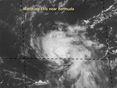
Currently we are watching a system southeast of Bermuda to possibly be the first depression of the season.
It's moving Northeastward, so it won't be affecting land. But it's starting to form a low level circulation, so there is a good chance we'll see a depression this evening or tomorrow.
In the Atlantic between Africa and the Caribbean, there's another wave, but it's fairly disorganized at the moment.
NRL Monterey Marine Meteorology Division Forecast Track of Active Systems (Good Forecast Track Graphic and Satellite Photos) (Backup site)
Follow worldwide SST evolution here:
Global SST Animation
NASA GHCC Interactive Satellite images at:
North Atlantic Visible (Daytime Only), Infrared, Water Vapor
Some forecast models:
NGM, AVN, MRF, ETA ECMWF
DoD Weather Models (NOGAPS, AVN, MRF)
AVN, ECMWF, GFDL, MM5, NOGAPS, UKMET
Multi-model plots from WREL
Other commentary at Mike Anderson's East Coast Tropical Weather Center, Robert Lightbown/Crown Weather Tropical Update Accuweather's Joe Bastardi (now subcriber only unfortunately), Cyclomax (Rich B.), Hurricane City , mpittweather , Tropical Weather Watchers.Com (JasonM) Gary Gray's Millennium Weather, Barometer Bob's Hurricane Hollow, Snonut,
Even more on the links page.
| LI Phil |
| (User) |
| Thu Jul 08 2004 04:34 PM |

|
|
|
Mike
Thanks for the new thread. Little too much vitriol on the last one.
James88--The wave certainly looks healthy. I wasn't going to give it much chance for development, but now I'm not so sure. I'd be surprised if it becomes Alex, but a TD may not be out of the question. It obviously got NRL's attention. The 11:30 TWO also "AN AREA OF DISTURBED WEATHER IS LOCATED ABOUT 250 MILES SOUTHWEST OF BERMUDA. ALTHOUGH THUNDERSTORM ACTIVITY IS LIMITED...THIS SYSTEM APPEARS TO BE DEVELOPING A SMALL SURFACE LOW CENTER. THIS SYSTEM HAS SOME POTENTIAL FOR FURTHER DEVELOPMENT OVER THE NEXT DAY OR SO AS IT MOVES NORTHEASTWARD AT 10-15 MPH."
If nothing else, it'll keep us busy...
Cheers,
LI Phil
| doug |
| (Weather Analyst) |
| Thu Jul 08 2004 04:42 PM |
|
|
Joe B. tropical update for Thursday implied that within the next week activity will increase. Interestingly he failed to even mention the Bermuda system, but he did focus on the wave at 40w which he called the first in a series. The european model ( of his preference) picked up on the wave now exiting Africa and developed it in about 7 days. The wave at 40 does have some rotation and little convection for now. It may have to be sacrificed to the shear machine in the E Carribean but could inaugerate the pressure changes necessary to lessen shear so the second system can go...at least that is the theorey. See ya! EDS.
| James88 |
| (Weather Master) |
| Thu Jul 08 2004 04:48 PM |

|
|
|
96L seems to have gained a little convection over what looks like a 'centre'. The convection also looks a little less ragged. Perhaps a tropical depression will emerge very soon.
| Rabbit |
| (Weather Master) |
| Thu Jul 08 2004 04:52 PM |

|
|
|
looking like Juan did last year about 12 hours before development, could be a TD by tomorrow morning
| Cycloneye |
| (Storm Tracker) |
| Thu Jul 08 2004 05:05 PM |
|
|
Thank you ED for posting a new thread that was needed because of this new event unfolding.It looks like a TD may be forming there but it will be a fish system as it is moving away from the US.
| James88 |
| (Weather Master) |
| Thu Jul 08 2004 05:18 PM |
|
|
|
|
From the looks of things, the system is becoming more organised. I wouldn't be surprised if another STDS was issued soon. Perhaps advisories will be initiated later today.
| Rich B |
| (British Meteorologist) |
| Thu Jul 08 2004 05:50 PM |
|
|
hey guys,
as this system is located 250 miles southwest of Bermuda, and is heading northeast at 10 to 15 mph, it looks set to impact Bermuda in around 18 - 24 hours. Seems to be getting much better organised, wouldnt be surprised to see it classified at 2100z this evening, and official watches or warnings for Bermuda at the same time.
| James88 |
| (Weather Master) |
| Thu Jul 08 2004 05:55 PM |
|
|
|
|
I agree - it might well be classified later today. However, it may need to develop some more organised convection, as the current activity seems to be waning. Also, am I the only one who thinks 96L looks a little 'stretched out'? These are probably just temporary.
| LI Phil |
| (User) |
| Thu Jul 08 2004 07:04 PM |
|
|
|
|
Even in their 11:27 tropical update, accuwx dismisses this system:
Today's Discussion July 8, 2004 11:27 a.m. The area of disturbed weather located approximately 275 miles east of Bermuda has shown no signs of development. (oops...they were talking about the system east of Bermuda, not the current 96L -- they didn't even mention it at all)
Check out the model runs from hurricane alley.
They all take it south of Bermuda and possibly straight to England. Wouldn't that be a rush for James & Rich if 96L gets named and hits...europe? Of course it wouldn't be Alex, just a extratropical low, but still...
Cheers,
LI Phil
| Jamiewx |
| (Storm Tracker) |
| Thu Jul 08 2004 07:18 PM |

|
|
|
NHC calling this a "possible tropical cyclone" under the special features section of the TWD at 2:05pm.
| Rich B |
| (British Meteorologist) |
| Thu Jul 08 2004 08:24 PM |
|
|
Well the latest from SSD on 96L still shows the system as 'TOO WEAK' and no TNumber assigned (1745UTC). Visible imagery shows a small circulation located on the southeastern edge of the elongated convection envelope. Waiting for the next TWO to shed more light on this feature.
| Steve |
| (Senior Storm Chaser) |
| Thu Jul 08 2004 08:39 PM |

|
|
|
Ed, it's just that since the way the board is set up isn't topic driven, I'm always in the news rather than the forum (though I do check in there from time to time). I've actually had to walk people into how to get to the news if they want to read this site. They'd always e-mail me, "the forum's dead." Then I tell them to click on the number behind the latest news headline, etc.
----------------------------------------------
As for the tropics at large, you can see some of the MJO influence in the Atlantic now with the colors all brightening up and everything. And who told you first to look out for a potential storm in Western Europe this year? /this guy/
One thing that was of interest in JB's column today was his prediction on the pattern we're going through this summer and the possible implications for tropical season. We start off with a ridge centered around New Mexico and one off the SE Coast. The NM ridge will surge ENEward and hook up with the SW Atalntic ridge until you get a trof split in the middle and the whole process starts over again. If he's got it together in that aspect along with the MJO & Monsoonal influence on African waves, then we might see some tropical activity between the 10th and 20th of July and probably not so much between the 20th of July and 10th of August. After that, we'd see the uptick in the action just in time for some of the hottest water temperatures of the season. Who knows what that could bring? Also, over the last few weeks, he has hinted that the waves have been slightly too far north to get rolling in the EPAC. One has to wonder when the seasonal influences nudge the ITCZ a bit north of where it's been if the entire SE and all the Islands aren't sitting ducks.
Steve
| doug |
| (Weather Analyst) |
| Thu Jul 08 2004 08:40 PM |
|
|
Hi again...I agree there is a vortex in the SE quardrant. My guess is: this will not pull itself together into a TD.
| Rich B |
| (British Meteorologist) |
| Thu Jul 08 2004 09:43 PM |
|
|
Doug,
loks like u were right for now. 96L remains a tropical disturbance at the 530pm TWO. However, if the thunderstorms can concentrate a little more then it could become a depression at anytime. I am a little surprised it wasnt classified yet, and of course there is always TD4 from 2000 to use as a comparison, especially as this disturbance looks to be closing in on Bermuda.
Also interesting to note they are still carrying the wave that was 95L in the outlook, even though there is no real convective activity to speak of in association with this wave. The TWD discussion does state that this wave has a large envelope, and i gues they are carrying it because it has potential to develop as it nears the Lesser Antilles, as hinted by a few models.
| LI Phil |
| (User) |
| Thu Jul 08 2004 09:53 PM |
|
|
|
|
Rich,
The former 95L will still be something to reckon with once it clears the "dead zone" it's now in (give it 48 hours). Once it gets to the Lesser Antillies, look for it to redevelop. Not saying it will (or will even get there, but I wouldn't bet against it), but if it does it should be in a more favorable environment. GFS and Joe B both hint that this will get off of S. Fla and into the gulf next week.
Regardless of whether 96L makes it to TD status, looks like you and James are going to feel some of its effects down the road.
Cheers,
LI Phil
| javlin |
| (Weather Master) |
| Thu Jul 08 2004 10:59 PM |
|
|
Both AVN and CMC seem to hint at this possibility but it is short lived.What was interesting was AVN's look beyond that coming offf Africa.I cannot remember which models were good where.Maybe somebody hear could clear that up.The model that AVN had was a little strong I would think.
By the way could somebody please" TURN OFF THE FAN IN PANAMA".
| HanKFranK |
| (User) |
| Fri Jul 09 2004 02:17 AM |

|
|
|
18z run looks very docile and dull compared to the last 3 days. something in gfs encoded mind must have remembered "oh, its july". vigorous waves are still present in the basin, only now there isn't much model hoopla over them. former 95L is progessing, now near 43w. it should be near 50w early saturday and from there on comes its real chance at development. gfs has a slightly more active TUTT than recent runs, though still probably not enough to preclude development. it's best chances are prior to the islands, july 10-11. the wave gfs was most enthusiastic about, near 30w, is trailing far to the south just as indicated. it has plenty of convection going for it, though not a great deal of organization. it may look better over time, but would likely be a couple days from depression stage. another wave should come off tomorrow or saturday and behave in the spirit of its immediate predecessors.
the northwest atlantic also has that interesting (though underachieving) feature 96L. it lacks the steady convection of a true depression, but may have some of the cyclonic structure. mediocre chances as it moves northeastward (fair environment, decent ssts, short time slot, other competing convection). this was an mcc core that was trailing the feature to its ne that was of interest a couple days ago.. may have a similar open-ended life cycle and never develop.
i'm feeling less confident about getting a storm or two out of the current activity.. but will be surprised if nothing gets going during the next few days.
by the way, potential season-wide implications as the strongly negative soi of june has caused much more extensive positive sst anomalies in the pacific from 150w to west of the dateline. a may-like positive soi rebound could trip this trend up, but if it doesn't we may be leaning to weak warm enso in august.
HF 0218z09july
| James88 |
| (Weather Master) |
| Fri Jul 09 2004 03:18 PM |
|
|
|
|
After being devoid of much convection for the last few hours, the satellite images show new convection flaring up.
96L Satellite Image
However, the TWO says it now has little potential for further development. In fact, no development is expected for the next few days. Looks like the Atlantic may be about to go quiet again. Still, maybe one of the waves in the Atlantic will take us by surprise.
| doug |
| (Weather Analyst) |
| Fri Jul 09 2004 04:16 PM |
|
|
The NHC does not seem to interested in that little low any more...it is poorly organized, all the convection on the west and it is experiencing blow off...I agree with the NHC that it has a very small chance of further development, and they probably don't want to classify it any way.
The best chance of an organized system is the former 95L at around 45W which has a low and no convection, but if it stays intact for the next several days could get into an increasingly favorable environment in the NW Carribean by Tuesday or Wednesday. Other than that not much on the board right now. EDS.
| Steve |
| (Senior Storm Chaser) |
| Fri Jul 09 2004 07:19 PM |
|
|
|
|
I'm somewhat impressed with the wave crossing the Yucatan right now. With the ULL in the Bay of Campeche backing away SW, there is some ridging building overtop. I don't think the chances are all that great that anything's going to develop, but the signature is there. Were this August or September, it's got that kind of look where you'd bet 70/30 that it was a go.
Steve
| James88 |
| (Weather Master) |
| Fri Jul 09 2004 07:31 PM |
|
|
|
|
The TWO isn't calling for any further development of this wave. Nonetheless, it is fairly impressive.
| javlin |
| (Weather Master) |
| Fri Jul 09 2004 07:32 PM |
|
|
I know what you mean Steve.Old 95L holding on to it's circulation also just no convection to speak of.Do not know if I am reading this right looks like the steering currents at the surface move it S of the islands and into the GOM.I see high clouds going E and the low ones going W.What about that moisture just now moving into the GOM from your home state.The two masses seem to be heading on collision course.
| Rabbit |
| (Weather Master) |
| Fri Jul 09 2004 07:53 PM |
|
|
|
|
i dont remember who forecast Alex before Jul 15, but it is looking very doubtful that it will occur
btw, here is my forecast per month
JUL 1
AUG 5
SEP 5
OCT 3
NOV 1
i may have to update this if there are no storms in the next week
| Steve |
| (Senior Storm Chaser) |
| Fri Jul 09 2004 07:53 PM |
|
|
|
|
That energy was part of a wave as well. It was storming this morning when I woke up, but it's all moved west of here. We're actually supposed to get up into the mid 90's for only the 2nd time this summer over the weekend. I'll believe it when I see it because it's only not rained about 3 days since mid June. Nonetheless, there's rain headed for Texas and Mexico.
Steve
| James88 |
| (Weather Master) |
| Fri Jul 09 2004 08:11 PM |
|
|
|
|
This is a indeed a very slow start. We were spoilt last year with all the early activity, but than last year was unusual in a number of ways. I think it's fair to say that we'll probably have a slightly above average year, it's just that most of the activity will take place in a concentrated period of several weeks (as in 1998). I may be wrong, but that's just my opinion (for what it's worth). Anyway, Rabbit's numbers seem reasonable, with an active August. The last time 5 formed in August was in 2000. That year was a slow starter as well - Alberto didn't form until August 4th! I'm starting to wonder whether we'll have a similar wait this year.
| Unregistered User |
| (Unregistered) |
| Fri Jul 09 2004 08:37 PM |
|
|
Does anyone notice that the cloud signature over the Yucatan has a curvature to it? Looks very interesting from where I'm sitting and wondering if anyone else has been watching it?
Bobbi
| LI Phil |
| (User) |
| Fri Jul 09 2004 08:56 PM |
|
|
|
|
Before we throw in the towel on July development, keep your eyes on ex-95L. I'm not saying it will develop, but it has stayed "alive" on its trek from Africa. If it can make it to the west carib/gom, it just may become a "playa".
96L looked good yesterday, but today...fading fast.
Probably not a lot to look for this weekend, but early next week maybe...just maybe.
Cheers,
LI Phil
| James88 |
| (Weather Master) |
| Fri Jul 09 2004 09:02 PM |
|
|
|
|
You're probably right Phil. If past seasons have shown us anything it's not to write these systems off too soon. Anyway, we've still got 3 weeks left in July, so a lot could happen.
| summercyclone |
| (Weather Hobbyist) |
| Fri Jul 09 2004 09:12 PM |

|
|
|
Well, I could be on a limb here, but I think there is a very good chance for Alex (or at least a TD) in the Gulf this weekend, the Yucatan system is very impressive and just has that "look" (as Steve said)...both Steve and Jav (and Bobbi) are on it, I think we have a show starter. If I am wrong...hey, I am wrong!!
I'll call the ball...lets see if I land or have to bail out. Only inhibit may be proximity to land, if it gains a little latitude (which it seems to be doing) < watch out (no pun).
PS--not a slow start, average so far.....
sc

Just looked ata close up loop, it appears a vorticity center may be developing over the central YP, moving WNW....next 24 hrs will tell the tale for development.....
| James88 |
| (Weather Master) |
| Fri Jul 09 2004 09:26 PM |
|
|
|
|
Despite the system's proximity to the Yucatan, it seems to be getting better organised. I'm not saying it will develop, but it is something that bears a look every now and again. As Steve and summercyclone have said, it has "the look". There is warm water in the area, but there does seem to be some dry air to the SW. If it gets drawn into the system, it could put an end to the thunderstorm activity.
| LI Phil |
| (User) |
| Fri Jul 09 2004 11:18 PM |
|
|
|
|
Well it is a wave interacting with an upper level trof, and it is producing a bunch of t-boomers, but it's not going to develop into anything. Surprisingly, it had a better signature over land, really cold cloud tops. As it moved over water, things started going downhill.
96L is toast...95L struggling to hold on, but it is holding on. A couple more waves off of Africa yesterday and today. I still think our best bet is the shell of the former 95L.
Guess the mess off the Yucatan bears watching, but I wouldn't expect anything to come of it.
Cheers,
LI Phil
| javlin |
| (Weather Master) |
| Sat Jul 10 2004 12:13 AM |
|
|
Post deleted by javlin
| LI Phil |
| (User) |
| Sat Jul 10 2004 12:21 AM |
|
|
|
|
Jav,
I looked at your link then went to accuwx pro which has enhanced IR and I'm just not seeing what you're seeing. I could very easily be wrong, but as the convection moves off land over water, it is totally losing it's punch. I do think this wave will hold together and eventually be a rainmaker for Mex/Tex, but I don't see it developing...just my opinion...I could be wrong.
Cheers,
LI Phil
| javlin |
| (Weather Master) |
| Sat Jul 10 2004 05:29 AM |
|
|
guess I am wrong
| Rob_M |
| (Weather Hobbyist) |
| Sat Jul 10 2004 03:17 PM |

|
|
|
Finally back after week's absence...guess I didn't miss too much.
 Still catching up on everything but I wouldn't get excited about the GOM disturbance. Convection is still being enhanced by shear aloft...sort of the same non-tropical situation as with the GOM low we tracked a few weeks ago. With this one, steering flow suggests a more westward track, but again, just some ULL-enhanced convection. Nothing that poses a threat to develop into a TC.
Over the past week, we've seen stronger tropical waves traverse the Mean Development Region. The apparent boom in tropical wave activity is in part due to the negative MJO pulse moving over the area...later this month a positive MJO will take over and we'll probably see things die down a bit. The next negative MJO, if timing is right, should come around the second half of August...PERFECT timing for everything to break loose. I still think there's a decent chance of Alex forming later this month in the Mean Development Region just before the negative MJO exits...GFS still picks up on lows east of the Windward Islands in the long-range, we'll see if continues to for many runs to come, persistence of course is the big key.
Also want to mention that a real dull start does NOT correlate to a duller season. Some hyperactive seasons (with NTC above 150%) where the first named storm didn't form until sometime after July 15 include 1950, 1955, 1961, 1969, and 1998. Most of those years really didn't take off until the end of August...again, we're talking about big dawg years here. What happens in the first 2 (or even 2.5) months has no relationship with what happens around the peak or later in the season.
| LI Phil |
| (User) |
| Sat Jul 10 2004 04:21 PM |
|
|
|
|
Rob
Great post. Think you pretty much summed it up for the next couple of days. You and Steve are all over the MJO flip...if it does pan out like you guys think it will, then August through the heart of the season should provide us with quite a show.
I'm a little less confident today than earlier in the week about former 95L developing, but it still looks to have an ounce of energy left.
ho-hum. maybe next week.
Cheers,
LI Phil
| James88 |
| (Weather Master) |
| Sat Jul 10 2004 05:38 PM |
|
|
|
|
I think it is reasonable to expect a named storm this July. It would be very surprising if one did not form. Records since 1886 dictate that a tropical storm or hurricane will form in July about seven times every 10 years. In the last 10 years six seasons have experienced a named storm in July. Therefore, the averages dictate that a storm will form this month. Of course, the weather pays no attention to statistics, so there is no guarantee that anything will form. Even so, I'd be surprised if we didn't have Alex at some point in the next 21 days.
| rmbjoe1954 |
| (Weather Master) |
| Sat Jul 10 2004 07:22 PM |

|
|
|
This is so unreal. I have not seen it so dry in East Central Florida since I have been here (1986). My grass is still brown and has been since May!
Is it possible that there is too much dry air for the formation of any system? I understand that Cuba has been in a drought situation as well. I wonder what impact this will have on any stroms forming in July.

| James88 |
| (Weather Master) |
| Sat Jul 10 2004 07:49 PM |
|
|
|
|
Check out the wave to the east of Puerto Rico. It now has a lot more convection than it did a few hours ago. There is a mass of dry air to the west which could disrupt any development. Does anyone have any thoughts on this wave and its chances for development?
| Old Sailor |
| (Storm Tracker) |
| Sat Jul 10 2004 08:17 PM |

|
|
|
The wave old 96L to the east of Puerto Rico is not only running into dry air also wind shear, the convection is most likely from afternoon heating. As for development would wait to see if holds over night and how it looks after or at Puerto Rico.
| Unregistered User |
| (Unregistered) |
| Sat Jul 10 2004 08:20 PM |
|
|
Sorry for typo should have said old 95L.
| rmbjoe1954 |
| (Weather Master) |
| Sat Jul 10 2004 09:00 PM |
|
|
|
|
1 Late July
5 August
6 September
3 October

| Rabbit |
| (Weather Master) |
| Sat Jul 10 2004 09:02 PM |
|
|
|
|
Maybe its me, but the system in the Gulf seems to have a vortex to the north of the Yucatan--don't thing that it is all impossible for development.
Historical note--several storms in recent years have developed in the gulf due to wave interaction with an upper low:
Hermine, 9-17-98
Harvey, 9-19-99
Beryl, 8-13-00
Allison, 6-5-01
Barry, 6-5-01
Bill, 6-29-03
it is also interesting to note that since 1967 (when satellite surveillance wasnt limited to one or two images a day) there has never been a year with no depressions before August
only 1967, 1972, 1982, 1993, and 2000 went through July without a depression
also, in case anyone is interested, the years with no June depression are:
1969, 1971, 1978, 1980, 1983, 1985, 1988, 1990, 1998, 2002, and this year
| Rabbit |
| (Weather Master) |
| Sat Jul 10 2004 09:07 PM |
|
|
|
|
little question:
When will Alex form, when will it form, and what will it form from?
my guess: 7-26, East Atlantic, Tropical Wave
| LI Phil |
| (User) |
| Sat Jul 10 2004 09:14 PM |
|
|
|
|
Joe1954,
I see you're calling 15 named storms. Wanna take a crack at TS/HUR/MAJ?
Bugs,
I won't say it's 100% against development for the Yucatan mess, but probably 99%. It will be near the Tex/Mex border sometime tomorrow, so there's probably not enough time for anything to develop. It WILL, however, be a huge rainmaker.
I think we're all so anxious for a first storm that we're all jumping on every bit of disturbed weather hoping it's "the one".
While it certainly wouldn't be unprecedented not to have a named storm by August, it wouldn't necessarily mean a slow season, as Rob pointed out earlier. If the MJO flip noted by Steve and Rob (and JoeB) does happen as discussed, we may not have much activity until mid-August...but then...BAM.
Cheers,
LI Phil
| Old Sailor |
| (Storm Tracker) |
| Sat Jul 10 2004 09:17 PM |
|
|
|
|
The wave is moving to fast for anything to develop, by tomorrow it will be making land fall in Texas, maybe if had 2 or 3 days to get it's act together or this was in Sept. Then would say had a chance.
| rmbjoe1954 |
| (Weather Master) |
| Sat Jul 10 2004 09:21 PM |
|
|
|
|
Hey Long island:
I'll take a crack at it..
1 TS in July
3 TS/2 Hurr in August
1 TS/3 Hurr/2 Major Hurr in Sept
2 Hurri/1 Major Hurr in Oct
Badly needed rest in November!!
| LI Phil |
| (User) |
| Sat Jul 10 2004 09:26 PM |
|
|
|
|
Joe1954,
So that's 15/10/3? Wow...10 hurricanes. As long as they spin the fishes that's fine with me.
Bugs,
I already made my (incorrect) guess for Alex, but if you're giving me another shot, I'll have to run with my earlier call on 95L. I'll say west carib 7/12 or gom 7/13.
Cheers,
LI Phil
| Old Sailor |
| (Storm Tracker) |
| Sat Jul 10 2004 09:43 PM |
|
|
|
|
Phil:
Old 95L is moving WNW if anything would hit Florida or up the east coast, The wind shear is still strong, reason why moving WNW as of now plus dry air. It would be a long shot.
Dave
| Unregistered User |
| (Unregistered) |
| Sat Jul 10 2004 09:49 PM |
|
|
Living nearby in Stuart , I agree. I have not seen this dry a period during June and July in 15 years, nor can I remember the last time we had a normal summer rain as year after year it is mostly dry with brief heavy rain periods to bring the average up . We are past 50 years since the last major hurricane in our area.
| Unregistered User |
| (Unregistered) |
| Thu Jul 15 2004 12:16 AM |
|
|
It seems from the Tropical Atlantic Discussion that wants the SAL calms down we could be in business. LOL
TROPICAL ATLC...
A MID-UPPER LEVEL RIDGE IS POSITIONED WELL N OF THE AREA WITH
DEEP ELY FLOW AND GENERALLY LOW SHEAR VALUES OVER MUCH OF THE
TROPICAL ATLC WATERS. HOWEVER...VERY DRY/STABLE AIR IN
ASSOCIATION WITH A SAHARAN AIR LAYER CONTINUE TO RESTRICT TSTM
ACTIVITY. THE ONLY SIGNIFICANT PERTURBATION IS A WEAK INVERTED
UPPER TROUGH NOTED ALONG 35W. PRESSURES IN THE DEEP TROPICS ARE
BELOW AVERAGE WITH WEAKER TRADES THAN AVERAGE AS WELL.

| JasonM603 |
| (Verified CFHC User) |
| Thu Jul 15 2004 02:17 AM |

|
|
|
Quote:
It seems from the Tropical Atlantic Discussion that wants the SAL calms down we could be in business. LOL
TROPICAL ATLC...
A MID-UPPER LEVEL RIDGE IS POSITIONED WELL N OF THE AREA WITH
DEEP ELY FLOW AND GENERALLY LOW SHEAR VALUES OVER MUCH OF THE
TROPICAL ATLC WATERS. HOWEVER...VERY DRY/STABLE AIR IN
ASSOCIATION WITH A SAHARAN AIR LAYER CONTINUE TO RESTRICT TSTM
ACTIVITY. THE ONLY SIGNIFICANT PERTURBATION IS A WEAK INVERTED
UPPER TROUGH NOTED ALONG 35W. PRESSURES IN THE DEEP TROPICS ARE
BELOW AVERAGE WITH WEAKER TRADES THAN AVERAGE AS WELL.
Yep...
http://www.cpc.ncep.noaa.gov/products/Epac_hurr/hgt_anom_1000_10d.html
http://cimss.ssec.wisc.edu/tropic/real-time/wavetrak/sal-atl.html