MikeC
|
| (Admin) |
| Mon Jul 19 2004 01:41 PM |
|
|
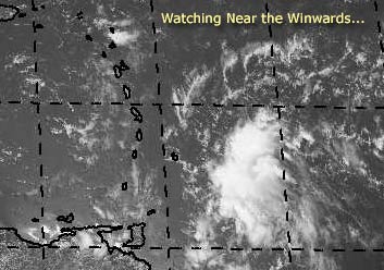
There's a system that could develop east of the Winwards. I'm not too sure it will last if it does though, the environment ahead of it isn't too great to be sustaining a system.
We'll be watching it though.
Mike's Tropical Development Probability Scale
Code:
forget it) 0 1 2 3 4 5 6 7 8 9 10 (sure thing)

          [-----*----------------]
It hasn't reached invest status yet, but we are watching.
Event Related Links
Martinique Radar
The Caribbean Hurricane Page - updates from the islands
Caribbean Island Weather Reports
General Links
NRL Monterey Marine Meteorology Division Forecast Track of Active Systems (Good Forecast Track Graphic and Satellite Photos)
Check the Storm Forum from time to time for comments on any new developing system.
Follow worldwide SST evolution here:
Global SST Animation
NASA GHCC Interactive Satellite images at:
North Atlantic Visible (Daytime Only), Infrared, Water Vapor
Some forecast models:
NGM, AVN, MRF, ETA ECMWF
DoD Weather Models (NOGAPS, AVN, MRF)
AVN, ECMWF, GFDL, MM5, NOGAPS, UKMET
Multi-model plots from WREL
Other commentary at Mike Anderson's East Coast Tropical Weather Center, Independentwx.com, Robert Lightbown/Crown Weather Tropical Update Accuweather's Joe Bastardi (now subcriber only unfortunately), Cyclomax (Rich B.), Hurricane City , mpittweather , Tropical Weather Watchers.Com (JasonM) Gary Gray's Millennium Weather, Barometer Bob's Hurricane Hollow, Snonut,
Even more on the links page.
| Unregistered User |
| (Unregistered) |
| Mon Jul 19 2004 01:46 PM |
|
|
Maybe like 4.7 or 5.4 ..in that range.
Has a definite twist, yet hard to see what's going on under the cloud cover. Would bet there is no west wind yet indeed, but will there be.
Truth is... that my friends is a real good example of a nice, developing Tropical Wave.
Been a while, but I recognize it.
Wish it would slow down just a drop however at this point one shouldn't argue with success I suppose.
Watching..bobbi
| Rabbit |
| (Weather Master) |
| Mon Jul 19 2004 01:49 PM |

|
|
|
take a look at this
and this off of Africa
when it looks that organized on IR, you know its strong
could be a TD in a day or so
| LI Phil |
| (User) |
| Mon Jul 19 2004 02:16 PM |

|
|
|
Just watched JBs tropical video...man is he jumping all over 97L. He thinks, with modeling to back it up, that the system is going to head north, over Hispaniola and into the Bahamas by the weekend. A ridge is building in near the Islands, allowing it to sneak through the Antilles towards DR/Haiti. A TUTT drops down, but it misses 97L, so it continues it's northwest trek all the way to the Bahamas. At that point, models show it stalling and strengthening, eventually taking aim at the EC.
He's very concerned for the areas from Miami all the way up to NE.
A second scenario keeps 97L on a more southerly track, which would eventually take it either across or just south of Fla and into the GOM. He's not as keen on that one, but it is of course a possibility.
In any event, he thinks this one will be the one and needs to be watched.
Hey bugs, I guess you figured out the "URL" thingy? That wave has TD potential too.
And of course, the GOM is still just waiting to explode.
Cheers,
LI Phil
| Rabbit |
| (Weather Master) |
| Mon Jul 19 2004 02:26 PM |
|
|
|
|
SPECIAL TROPICAL DISTURBANCE STATEMENT
NWS TPC/NATIONAL HURRICANE CENTER MIAMI FL
215 PM EDT MON JUL 19 2004
SQUALLS ON THE LEADING EDGE OF A TROPICAL WAVE ARE APPROACHING THE
SOUTHERN WINDWARD ISLANDS. AS THESE SQUALLS MOVE THROUGH THE
ISLANDS THIS AFTERNOON AND EVENING THEY WILL LIKELY BE ACCOMPANIED
BY BRIEFLY HEAVY RAINS AND WIND GUSTS TO NEAR TROPICAL STORM FORCE.
THIS SYSTEM HAS SOME POTENTIAL TO DEVELOP INTO A TROPICAL
DEPRESSION OVER THE NEXT DAY OR SO.
FORECASTER FRANKLIN
take a look at this
what i thought yesterday was a weak wave with an outflow boundary appears now to be a developing tropical depression
what i thought was an outflow boundary is actually a strong rain band trying to block the center from the shear
| Unregistered User |
| (Unregistered) |
| Mon Jul 19 2004 02:43 PM |
|
|
Well, I must say Rabbit you're getting good at this.
Thanks for the sites, made me smile.. wasn't really in the mood to but you did.
and.. gee.. got a real system here to think upon don't we?
Took a long lunch and wandered around and came back to see a very vigorous wave.. that deserved a statement.
Can't someone get ship reports or far our island data or something... looks almost like its moving in for the kill.
Bobbi
| LI Phil |
| (User) |
| Mon Jul 19 2004 02:45 PM |
|
|
|
|
buoy & ship data
| Unregistered User |
| (Unregistered) |
| Mon Jul 19 2004 02:59 PM |
|
|
mesmerizing
http://www.ssd.noaa.gov/PS/TROP/DATA/RT/watl-vis-loop.html
| Rabbit |
| (Weather Master) |
| Mon Jul 19 2004 03:07 PM |
|
|
|
|
latest carribean radar
| LI Phil |
| (User) |
| Mon Jul 19 2004 03:07 PM |
|
|
|
|
Here's the link for the National Data Buoy Center, FYI:
NDBC
| Unregistered User |
| (Unregistered) |
| Mon Jul 19 2004 03:20 PM |
|
|
I'm sure most of you have this one, but for those of you that don't:
http://www.srh.noaa.gov/sju/caribm.html
A note:
There is light wind in Trinidad W@5 pressure dropping 29.94
A bit North in Barbados winds are E@17 with slightly higher pressure 29.97.
| Unregistered User |
| (Unregistered) |
| Mon Jul 19 2004 03:25 PM |
|
|
very cool, Rabbit!
sc

| Unregistered User |
| (Unregistered) |
| Mon Jul 19 2004 03:27 PM |
|
|
Looks like closed circulation to me.....east to the north of the center and west to the s...maybe an upgrade soon.....NHC can read the reports too....pressures fairly low considering distance to center....
sc
| hurricane_run |
| (Storm Tracker) |
| Mon Jul 19 2004 03:43 PM |

|
|
|
look at this ir in the pacific
http://www.ssd.noaa.gov/PS/TROP/DATA/RT/float-ir4-loop.html
| Unregistered User |
| (Unregistered) |
| Mon Jul 19 2004 03:45 PM |
|
|
Like St. Vincents to start with?
| Rabbit |
| (Weather Master) |
| Mon Jul 19 2004 03:50 PM |
|
|
|
|
look at the longitude--that is in the eastern pacific
dont worry, i made that same mistake a few hours ago on another forum site
| hurricane_run |
| (Storm Tracker) |
| Mon Jul 19 2004 03:56 PM |
|
|
|
|
ooops thats a mistake on me but it still is worth looking at
| hurricane_run |
| (Storm Tracker) |
| Mon Jul 19 2004 04:03 PM |
|
|
|
|
if you look at this ir the correct one you can see has more
convection with it
http://www.ssd.noaa.gov/PS/TROP/DATA/RT/watl-ir2-loop.html
| Unregistered User |
| (Unregistered) |
| Mon Jul 19 2004 04:10 PM |
|
|
wont tell you when i was last excited like this.. dying to know what nhc is going to do at five..
really has a nice explosive look and if it does develop would venture to say its going to have a classic NE quandrant
thanks guys
| Unregistered User |
| (Unregistered) |
| Mon Jul 19 2004 04:11 PM |
|
|
If you look at the data between these three areas:
Trinidad:
http://weather.noaa.gov/weather/current/TTCP.html
Grenada:
http://weather.noaa.gov/weather/current/TGPY.html
Barbados:
http://weather.noaa.gov/weather/current/TBPB.html
Check out the wind direction, speed, and pressures.
These three locations are within less than 200 miles of each other.
Somethin's a brew'n

| Tropics Guy |
| (Storm Tracker) |
| Mon Jul 19 2004 04:12 PM |

|
|
|
Seems to be organizing nicely, wish they would put the Sat. floater on it soon.

TG
| Rabbit |
| (Weather Master) |
| Mon Jul 19 2004 04:20 PM |
|
|
|
|
will not be classified at 5 because the S wind is W of the center
| Unregistered User |
| (Unregistered) |
| Mon Jul 19 2004 04:22 PM |
|
|
what were the last cords used for current position of the model runs
saw this somewhere but not sure if thats correct, dont think so: "10.7N 55.5W "
what are the cords they were running the models off of?
| Rabbit |
| (Weather Master) |
| Mon Jul 19 2004 04:24 PM |
|
|
|
|
thats where it likely was (or appeared to be) at around 8 am this morning
| LI Phil |
| (User) |
| Mon Jul 19 2004 04:25 PM |
|
|
|
|
STRONG TROPICAL WAVE OVER THE TROPICAL ATLC WATERS ALONG 56W/57W WILL MOVE W 20 TO 25 KT. SOME DEVELOPMENT OF THE WAVE IS POSSIBLE OVER THE NEXT DAY OR TWO. STRONG GUSTY WINDS WILL ACCOMPANY THE WAVE INTO THE E CARIBBEAN. THE WAVE WILL BE
ALONG 64W TUE AFTERNOON AND ALONG 70W WED. THE WAVE IS EXPECTED REACH THE CENTRAL CARIBBEAN THU AND THE NW CARIBBEAN FRI AND SAT.
| Kevin |
| (Weather Master) |
| Mon Jul 19 2004 04:27 PM |

|
|
|
Time to jump back in, looks like we'll see action pretty soon.
Check this out:
http://twister.sbs.ohio-state.edu/surface/caribbean.gif
We still don't have a west wind. From the looks of this map, we don't have a closed circ yet. I wouldn't worry though, the system seems to be organizing this afternoon despite rapid forward movement. I have a weird (and probably incorrect) feeling that NHC will classify this as a TD at 5. Ah, that young gut.
The models are trending more westerly with their tracks this afternoon. Sure, we have a big trough that's going to weaken this Bermuda High over the next couple of days. But this system is still moving quickly westward, indicative of a strong east-to-west flow. So while I feel that a northerly movement is lurking as a possiblity, a more westerly track is interesting to me. Besides, climotology doesn't necessairily support this system curving to the north.
Let the storms roll...

| Unregistered User |
| (Unregistered) |
| Mon Jul 19 2004 04:28 PM |
|
|
Quote:
wont tell you when i was last excited like this.. dying to know what nhc is going to do at five..
really has a nice explosive look and if it does develop would venture to say its going to have a classic NE quandrant
thanks guys
What you said last para is exactly what iIwas thinking...however, having said that...they won't do 'anything' at 5..maybe, at 11, but, more likely not until tomorrow...from what I am reading they are not seeing a surface circ yet...
twt.
sc
| Rabbit |
| (Weather Master) |
| Mon Jul 19 2004 04:30 PM |
|
|
|
|
lowering my forecast by one--there will not be a storm this month
i am looking at the winds, and the fact that the wind is out of the south to the west of the circulation indicates that it is very disorganized at the surface
also, the wave off of africa is weakening
| Unregistered User |
| (Unregistered) |
| Mon Jul 19 2004 04:32 PM |
|
|
http://www.ssd.noaa.gov/PS/TROP/DATA/RT/FLOAT/VIS/20.jpg
| Shan |
| (Verified CFHC User) |
| Mon Jul 19 2004 04:33 PM |
|
|
Although this is my third season here, I rarely ever post. I don't feel that I know enough but I have learned alot from just reading all of your posts. Anyway, I just looked at *our wave* and I can see a definite spin! Pretty impressive. I think we will have a t.d or maybe even t.s. Alex soon.
| Unregistered User |
| (Unregistered) |
| Mon Jul 19 2004 04:37 PM |
|
|
This is a site for tropical weather enthusiasts not just professionals. I'm sure after 3 years of watching you have what to say. It's a forum, as long as we are on topic it doesn't matter if we have a PHD or grave diggers that like to study tropical weather.
That's my opinon mind you but am sure others agree.
And, your thoughts on what may be Alex are worthy of reading.
| LI Phil |
| (User) |
| Mon Jul 19 2004 04:41 PM |
|
|
|
|
>>> lowering my forecast by one--there will not be a storm this month
Whoa Bugs...don't you think you're writing off this (and any other possible developments--we still have 12 days left in July) way too soon? Almost every site I've checked this afternoon is big on development, much more so than any of our other "false alarms" this season.
It won't be classified at 5:00, although Celia has just been added (which I called earlier on the Other Basins Forum, BTW). It probably won't be at 11:00 either, and maybe not for 24-48 hours if at all.
But to give up on the whole month? That's crazy talk man
MY wave will survive!
Cheers,
LI Phil
| Unregistered User |
| (Unregistered) |
| Mon Jul 19 2004 04:43 PM |
|
|
I disagree. NRL site now has it at 30kts Must be some type of organizing going on for it to have gone from 25kt to 30kts. Just my opinion.
http://www.nrlmry.navy.mil/tc_pages/tc_home.html
| Rabbit |
| (Weather Master) |
| Mon Jul 19 2004 04:57 PM |
|
|
|
|
1997 was forecast to be a big season as well
there were only 7 storms; i don't have much faith in the NHC forecasts
I'm also going to take a guess that the NHC didnt even investigate this, as they havent the whole year (except the low in the Gulf last month)
| Unregistered User |
| (Unregistered) |
| Mon Jul 19 2004 05:07 PM |
|
|
This is not '97!
| Unregistered User |
| (Unregistered) |
| Mon Jul 19 2004 05:09 PM |
|
|
And, NHC seems keen on it its potential.
Tropical Weather Outlook
Statement as of 5:30 PM EDT on July 19, 2004
For the North Atlantic...Caribbean Sea and the Gulf of Mexico...
A vigorous tropical wave...centered about 220 miles east of the
Windward Islands...is moving rapidly westward near 25 mph.
This system has become better organized today and has the potential
to develop into a tropical depression over the next day or so.
Even if there is no additional development...the wave is expected
to be accompanied by briefly heavy rains and wind gusts to near
tropical storm force as it moves through the Windward Islands
tonight.
Elsewhere...tropical storm formation is not expected through
Tuesday.
Forecaster Jarvinen
| LI Phil |
| (User) |
| Mon Jul 19 2004 05:15 PM |
|
|
|
|
Looks like it's "splitting" (not the correct met term), and the more northerly piece is really getting some serious t-boomers. Look at those super-cold cloud tops developing.
IR
WV
I think we may have a TD by tomorrow...
BTW, have any new Dvorak #s come out. I can only find them from 11:45 UTC, and there should have been an update since then.
Cheers,
LI Phil
| Old Sailor |
| (Storm Tracker) |
| Mon Jul 19 2004 05:24 PM |

|
|
|
I only give it about a 20% chance , 2 reasons why not is mid level low and thunder storms now moving away from the center of the low, 2nd once it passes the island no history record of a strom forming this time of yr in the carri. It may become a TD around Cuba.
| James88 |
| (Weather Master) |
| Mon Jul 19 2004 05:25 PM |

|
|
|
'97 was forecast to be a big year, but there was the unexpected development of a phenomenal El Nino event. Not an issue this year.
This is like Claudette last year - watching a wave approach and get better organised and waiting for the upgrade. Please let this wave be the one!

| Robert |
| (Weather Analyst) |
| Mon Jul 19 2004 05:28 PM |

|
|
|
Tobago airport reporting light 4-5 nnw to w winds in the past 4 hours. barbados reporting east at 25mph
| Rabbit |
| (Weather Master) |
| Mon Jul 19 2004 05:41 PM |
|
|
|
|
waters are warming off of Ecuador
btw, does anyone know where to find the current streamlines?
| James88 |
| (Weather Master) |
| Mon Jul 19 2004 05:47 PM |
|
|
|
|
You're correct, they are slowly rising. I may be wrong, but I don't think there is enough time for a strong El Nino to develop to have a strong influence over the season. Still, I may be wrong, so please correct me if I am.
Back to our friend in the Atlantic - it is looking quite good, and if it can persist, I think this is the best candidate for a long time. I don't dare take my eyes off this system - could be very interesting.
| LI Phil |
| (User) |
| Mon Jul 19 2004 05:50 PM |
|
|
|
|
There will NOT be an El Nino influence on the 2004 season!
| Rich B |
| (British Meteorologist) |
| Mon Jul 19 2004 05:59 PM |
|
|
Hey guys,
well doesnt 97L look good this evening... well developed with some possible banding features, and tanking along at a steady pace - 25 mph. At this speed it will be crossing the islands tonight. And i am guessing NHC will wait to see what data comes in from the islands to see if it needs classifying or remains an open wave! Therefore, i dont expect it will be classified til early Tuesday. However, looks like the islands could get some pretty rough weather this evening and tonight

| JasonM603 |
| (Verified CFHC User) |
| Mon Jul 19 2004 06:41 PM |

|
|
|
Note: Our forecast products are unofficial. Please read our disclaimer.
IWIC Atlantic Tropical Weather Discussion - 19 July 2004 - 6:45 PM EDT
We are continuing to monitor a vigorous tropical wave that is approaching the lower Winward Islands. The overall appearance of the wave has not changed much within the past 24 hours. However, there are a few interesting things that should be noted. An earlier SSMI pass clearly indicated that some dry air is wrapping into what appears to be mainly a mid-level circulation, since scatterometer winds are showing no signs of a surface circulation. The dry air entrainment will keep thunderstorm activity in check for the time being. Thunderstorms will continue to fire but they won't blossom enough for further development within the next 24 hours. In addition to dry air entrainment, infrared satellite imagery now indicates that the western fringe of the wave is being inhibited by light to moderate southwest shear. There is still some upper level ridging in place, so the wave is not expected to be sheared off completely anytime soon. Furthermore, the wave is still moving westerly at 25 miles per hour, and the bulk of the convection is just west of the center, certainly not a great sign for organization.
The wave will pass through the islands within the next 12 hours, with the potential for heavy rainfall and wind gusts as strong as tropical storm strength. Caribbean water vapor imagery reveals that dry air will continue to be a problem as the wave enters the eastern Caribbean. It would not be surprising if some of the convection were to diminish within the next 48 hours. However, upper level winds will still likely be marginally favorable for slow development.
The expected path of the wave is up in the air at this point. The global model consensus is for more of a west-northwest track through Puerto Rico and Hispaniola. The globals weaken the western periphery of the subtropical ridge, allowing the low level steering flow to shift from due east to east-southeast. The globals also indicate that upper level ridging will still be in place over the wave once it approaches the Bahamas. If this solution were to verify, all bets are off. There are signs that the subtropical ridge may build west later in the period, and that would cause the potential low to stall for the time being. Even with the ridge in place, the globals still indicate no development. As already said, all bets are off if this solution were to pan out. On the other hand, the tropical models keep the wave on a westerly path, placing the center south of Cuba and Jamaica in 120 hours. This would decrease the potential for development, as the central and western Caribbean are bone dry at the moment. There are no signs of conditions changing in the near term.
The most reasonable solution at this time appears to be that suggested by the global models. While the wave is still racing westward, the low level steering flow has changed slightly over the past 12 hours, in favor of the global model consensus. This keeps the door open for slow development. The eastern Caribbean is known as the graveyard for tropical storms, and conditions aren't exactly supportive for development in that area. But the wave will have to be monitored since it still appears to be heading into the western Atlantic, where a lot can happen. Very slow development is possible over the next several days.
Elsewhere, activity behind the wave is also beginning to increase. These features will have to be monitored as they gain latitude while approaching the lower Lesser Antilles.
http://independentwx.com/atlanticdiscussion.html
| javlin |
| (Weather Master) |
| Mon Jul 19 2004 07:37 PM |
|
|
I do not totally buy the NW motion later unless I see this system put on it's brakes.It's mass in motion it's got to slow down some to turn.The one example that I remember that made a right turn with little slow down was Erin into Pensacola.It seems you always will see a slowdown first .This system should be somewhere around the 70W mark by midnight tomorrow at this pace.Looks good but I think the development will be slow.What old Sailor said this is the boneyard for canes.I hope the system does not out run it's own thunderstom development.
| Unregistered User |
| (Unregistered) |
| Mon Jul 19 2004 07:43 PM |
|
|
Agreed Jason. I posted the same thing on this (shorter detail) on the previous thread on the dry air and shear. There is a very slight chance for this to develop in the near term but most likely will be over the weekend into next week once it gets near Grand Cayman. With a new trough coming down the eastern U.S. this could cause widespread rainfall throughout florida again and anything from this wave (if it does develop in the NW carribean) will pull it N up across florida. Too early to tell exactly where do to the strength and timming of the Trough. scottsvb
| Cycloneye |
| (Storm Tracker) |
| Mon Jul 19 2004 07:45 PM |
|
|
Regardless of what the wave does in terms of intensity I will recieve here in PR a good deal of squally weather from tommorow night depending on the track.
| LI Phil |
| (User) |
| Mon Jul 19 2004 07:58 PM |
|
|
|
|
Jason,
Excellent analysis, as always. Many good reasons for development NOT to occur. Even I don't think we'll see much improvement for the next 24-48 hours or so. However, accuwx doesn't have quite the same take on the situation:
"A strong tropical wave is located near 57 west, and some thunderstorms ahead of the wave are moving into the Windward islands of the Caribbean. This wave has a good low-level circulation, and will be watched closely for further development over the next couple of days as it moves through the Caribbean Sea. There is a chance that this system will become the first Atlantic tropical depression of season sometime Tuesday or Wednesday as it heads toward the west or northwest over the Caribbean."
And I'm certainly NOT saying they're right and you're wrong...far from it...you and Rob have been spot on so far.
However, with Blas and now Celia, you have to think there's some teleconnections somewhere down the road for Alex.
Luis, you're not going to see Alex, but you're probably in for a good 12 hours or so of some tropical mischief (you lucky bastid).
TWC's Steve Lyons is acknowledging this wave at least. He did just make a good point that the thunderstorm activity is separating itself from the LLC (which IS there), and that's certainly not indicative of strengthening. Plus, like Old Sailor said (and others), the eastern carib is NOT an area where tropical cyclones form.
Ne'ertheless, I'm banking on this puppy holding together long enough to get itself into a better area (where that is right now, I don't know), but I still wouldn't bet against this getting into the Bahamas sometime near the weekend and then, well, lets just wait and see.
Ya gotta admit that this one has held itself together better than ANYONE (except of course, me) thought. I'm willing to go down with the ship, but I will not abandon it.
Cheers,
LI Phil
| Rabbit |
| (Weather Master) |
| Mon Jul 19 2004 08:04 PM |
|
|
|
|
I was told earlier that I was writing this system off too soon, but apparantly it is starting to fall apart
there has been only one storm in the eastern Caribbean from Jul 20-31 (I say the 20th because you will probably all agree this will not be a TS at 11pm)
this and the fact that the Africa system is rapidly falling apart and elongating to the NW, along with water temps and the fact that we are getting late in the month, are why I lowered my forecast to 14. It was carefully studied and not just an impatient jump
| LI Phil |
| (User) |
| Mon Jul 19 2004 08:13 PM |
|
|
|
|
Perhaps you're not referring to me, but I didn't make any bones about THIS particular storm. I simply said there's 12 days left in July, and that stuff can happen. I'm still not convinced this will become Alex, or even a TD, but I'm going to ride it till it either becomes a TD or dies a horrible death, like all it's predecessors.
PEACE mi amigo
And happy early 21st b-day. I'll drink a toast to you on the 22nd!
LI Phil
(I didn't detect anything offensive - just an explanation of rationale for the change. Time to calm down. ED)
| Rabbit |
| (Weather Master) |
| Mon Jul 19 2004 08:14 PM |
|
|
|
|
TROPICAL WAVE OFF THE AFRICAN COAST ALONG 20W S OF 18N MOVING W
5-10 KT. THERE IS SOME DISCREPANCY BETWEEN THE DAKAR UPPER-AIR
SOUNDING AND LATEST SATELLITE IMAGERY. THE DAKAR SOUNDING SHOWS
A WELL-DEFINED WAVE PASSAGE ABOUT 24 HRS AGO IMPLYING THE WAVE
POSITION WOULD BE NEAR THE CAPE VERDE ISLANDS WHILE A MID-LEVEL
CIRCULATION IS NOTED IN SATELLITE IMAGERY NEAR 12N18W. THE
CURRENT POSITION IS A COMPROMISE OF BOTH DATA SOURCES AND
ASSUMES AN UNUSUALLY SLOW SPEED OF 5-10 KT. SCATTERED MODERATE
CONVECTION IS LOCATED FROM 8N-12N BETWEEN 13W-20W.
TROPICAL WAVE APPROACHING THE WINDWARD ISLANDS ALONG 58W S OF
16N RACING W 25-30 KT. SATELLITE IMAGERY CONTINUES TO SHOW A
WELL-DEFINED MID-LEVEL CIRCULATION WITH LOOSELY ORGANIZED BANDS
OF MODERATE CONVECTION TO THE N AND S. HOWEVER...GIVEN THE VERY
FAST MOTION OF THIS SYSTEM...ONLY AN INVERTED TROUGH SIGNATURE
IS NOTED WITHIN THE SURFACE WIND FIELD. DESPITE THE FAST
MOTION...THIS SYSTEM HAS THE POTENTIAL TO DEVELOP INTO A
TROPICAL DEPRESSION OVER THE NEXT DAY OR SO AS IT MOVES INTO A
FAVORABLE UPPER LEVEL PATTERN OVER THE E CARIBBEAN. REGARDLESS
OF DEVELOPMENT...SCATTERED TO NUMEROUS SHOWERS/TSTMS AND SQUALLY
CONDITIONS WILL SPREAD ACROSS PORTIONS OF THE LESSER ANTILLES
...PRIMARILY FROM TRINIDAD/TOBAGO TO GUADELOUPE...THIS EVENING
THEN ACROSS THE E CARIBBEAN TOMORROW.
the wave from yesterday in the carribean is almoat completely gone, and it was fairly strong going in
| Unregistered User |
| (Unregistered) |
| Mon Jul 19 2004 08:22 PM |
|
|
Perhaps 97L will make its mark in history by becoming a depression in the eastern Carribean; it can happen!
| Rabbit |
| (Weather Master) |
| Mon Jul 19 2004 08:25 PM |
|
|
|
|
predictions are just that--predictions. they have to be changed and refined as the situations change. I have held to the 15 storm forecast for quite a while, but we are nearing the end of teh month and everything comming off of Africa seems to be dissipating as it moves over water, and the upper winds over the Atlantic are going to remain unfavorable for the forseeable future.
As for my earlier mentioning of both systems looking good, the Africa system has become very poorly organized in recent hours, and the Antilles system has lost nearly all deep convection around the "center" if there is one, and there is nothing more that a weak wave at the surface, and it is moving into the eastern Caribbean
It is still possible for it to become a TD, and it is very likely we will have a TD this month, but i dont do depression forecasts, as there doesnt seem to be a noticable trend to use for seasonable depression forecasts, and the data doesnt go back as far as the storm data does
I am saying that nothing will make it through harsh winds or dry air long enough to be named, and I am still forecasting a very above average season, just a late start
one other thing: what was meant when everyone was talking about "analog" seasons? I'm not entirely sure what you meant, who ever mentioned it
| Rabbit |
| (Weather Master) |
| Mon Jul 19 2004 08:43 PM |
|
|
|
|
Barbados: E@17
St Vincent: E@14
Grenada: NNE@8
Trinidad : NE@3
it is not a closed low right now
this is my last post, because i am at a college computer, and they close in a few minutes
i will leave you all with this
| Unregistered User |
| (Unregistered) |
| Mon Jul 19 2004 09:07 PM |
|
|
Phil the system doesnt have a good low level circulation. The system is mainly in the mid levels. It is possible for it to progess to the lower levels but there is no indication of this doing so, infact the mid level circulation is weakening slightly.
scottsvb
|
Ed Dunham
|
| (Former Meteorologist & CFHC Forum Moderator (Ed Passed Away on May 14, 2017)) |
| Mon Jul 19 2004 09:34 PM |
|
|
Invest 97L now moving into the Windward Islands with a mid-level circulation near 12N 59W at 20/00Z. Movement continues to the west at 20kts. As with many embrionic systems, this wave had a couple of circulation centers - both mid-level. As stated yesterday in the Storm Forum, this was a wave worth watching for the next couple of days and that statement is still true. Without a cohesive convective core, any development (I'm still not convinced yet that there will be) will be slow. Movement should continue at a good pace to the west and eventually west northwest. If the wave should eventually strengthen, it would be less influenced by the low-level flow and would probably head in the general direction of the Yucatan Channel - but thats a long way off from now.
Regarding El Nino having an impact on this season...well, not very likely. We may eventually get to a weak El Nino state, but it will not happen until the season is over - perhaps in the December-January timeframe - and thats not certain either. The ENSO pattern so far this year is pretty close to the patterns that were observed in 1953 and 1990 - and to a lesser extent to 1969 (1969 was a tad warmer). The oceans are very conservative, i.e., it takes a long time for change to take place. Its probably smarter to look at month to month (or even season to season) changes in SSTs rather than week to week changes when you are trying to determine a trend.
Lots of great links were posted today - nice job!
Some of you need to take a deep breath and relax a bit. I know that everyone has been anticipating the first significant system - we've been spoiled by all of the early season activity over the past few years - but this year is still very normal in terms of the overall season - normally this happens about once every three years. The season is young and we've still got a long way to go - and don't get too excited about this wave. It may not amount to much - but others will, so save some energy and enthusiasm for those.
I know that some of you really don't like to hear this, but the keyword really is 'patience' when it comes to the tropics. Try to be tolerant of the other persons point of view since we are all here to enjoy a common pursuit.
Cheers,
ED
| Old Sailor |
| (Storm Tracker) |
| Mon Jul 19 2004 09:53 PM |
|
|
|
|
Well put Ed, I don't think 97L is going to do much myself, one never knows. Guess us old Bulls just walk now, let the young Bulls run down the hill they still have the excitement of the chase.
| Robert |
| (Weather Analyst) |
| Mon Jul 19 2004 09:59 PM |
|
|
|
|
Some one mentioned this erlier. The wave appeers to be splitting a piece continuing west and the bulk of the convection heading NW. Also that is what joe bastardi was alluding today. He does not think it will develop until the weekend he said a pattern is setting up in wich a very short trough will come down and it will get trapped between the trough and the ridge in or just east of the bahamas. His pattern recognitions sais that area is where it will head becuse of the trough position and a high pressure will be in place for excellent ventilation.
| HanKFranK |
| (User) |
| Mon Jul 19 2004 10:00 PM |

|
|
|
ed doesn't sound overly excited. reminds me of john hope sometimes with the cautious, mindful approach to things. same basic message here.
spent the weekend in north carolina; didn't bother to drop a post last night (saw incipient 97L but didn't have anything to say that hadn't already been said). as of tonight it looks decent, with bursting convection and some weak banding features. with its current translational speed and convective organization i doubt there is a surface low, probably a notable windshift line though. has to slow down to do much. expect the low level flow to carry it further south and east than model predicitons.. shear should be inhibiting but not fatal. i'd give it 3 in 10 to be a system in the nw caribbean thursday morning.
probably going to be a great deal of surface convergence and residual cool air aloft as the eastern longwave recedes during the week off the southeast coast. whenever the upper westerlies peel out, watch whatever gets caught between the TUTT and the next digging pulse on the eastern trough. nothing particularly suggestive on models, but there usually isn't at this stage in the game.
itcz/wave train doing nothing particularly unusual for this time of year. globals resolve a low here and there but aren't latchign strongly to anything from run-to-run.
the appearance of 97L came roughly a week after blas formed.. that connection worked out (as it sometimes does). with celia popping up there may be something else down the road.
SOI took a nosedive over the weekend, strongly negative again. if this keeps happening we will be into a weak el nino by fall. it's too late to nix the season, but our numbers could still be shaved down.
this front blowing through the southeast in mid july really got my attention. fairly amplified pattern, ups the chances of subtropical activity. one way or another there's a decent chance we get a july storm.
HF 0200z20july
| LoisCane |
| (Veteran Storm Chaser) |
| Mon Jul 19 2004 10:34 PM |

|
|
|
http://www.ssd.noaa.gov/PS/TROP/DATA/RT/FLOAT/VIS/20.jpg
looks like there is a blow up in the center of the wave
Have to reread the various comments. Read them tonight .. just now.
Great discussion.
Not sure what Bastardi meant about splitting and which part gets into the Bahamas. I think my mind is at saturation point for details and need to go to bed...but its so early. Was waiting for the 11 though it has weakened enough for the 11 to be meeker than the 5.
A good wave.. maybe the slowing down hurt it. It has been crusing along so fast that slowing down might inhibit it as opposed to invigorate it like it would if it were a formed storm.
Will see in the morning. Do believe its in a rebuilding stage and no i'm not wishcasting.
Good discussion today, enjoyed it.
Think July still may have a named system.. pretty sure it will.
Bobbi
| LoisCane |
| (Veteran Storm Chaser) |
| Mon Jul 19 2004 10:37 PM |
|
|
|
|
going to let you all duke it out tonight over the 11pm and check back in the morning and see how it all played out.
nite bobbi
| LI Phil |
| (User) |
| Mon Jul 19 2004 11:27 PM |
|
|
|
|
First off, peace y'all. Sorry about the 'attack' on our soon to be of legal drinking age Bugs/Rabbit.
Part of my frustration has to be attributed to my piece of s--- home computer, which feels as though crashing every five minutes (not kidding) is good for character building. Not so. (In fact, I'm just waiting for it to eat this post before I can post...)
Tomorrow will dawn another day and yes, Virginia, there will still be 97L to track. Whether it amounts to anything more, only time will tell. If it doesn't, then it doesn't. There's more to life than wishing, hoping for the first TD of the season.
Haven't gone on line (an of course, when your computer crashes every five minutes, that's difficult) all evening...thanks Scottsvb & Ed for posting...
Patience is a virture I've never embraced...will need to employ it as the season continues.
Still...DON'T WRITE MY WAVE OFF. It might make it. Albeit a small window closing ever so quickly, but it does have a still slim chance.
The fact that both Florida teams beat both NY baseball teams should have tipped me off that this was just not my night not withstanding, everyone enjoy the evening and "'till the morning comes' lets enjoy the e'en.
Cheers,
LI Phil
| Old Sailor |
| (Storm Tracker) |
| Mon Jul 19 2004 11:38 PM |
|
|
|
|
Phil, There is a upper level low north of PR at the Jet steam level , 97L may be pulled NW and or the wind shear caused by this upper level flow will keep 97L in check.
Dave
| javlin |
| (Weather Master) |
| Tue Jul 20 2004 12:22 AM |
|
|
HF do not know how to take this and someone correct me if wrong.I think one of the factors in 69 was an unusual cool front dropping into the GOM in 69.Just a memory from my college days on reading of Camiille.Might be wrong just something that stuck.Just how we always say that history repeats itself funny.Not that it will just how fragments of the puzzle come to play.
| James88 |
| (Weather Master) |
| Tue Jul 20 2004 03:24 AM |
|
|
|
|
The convection on the north side of the wave looks like it's weakening. However, convection is beginning to flare up to the south, so maybe it will begin to reorganise as it passes through the Caribbean.
| Cycloneye |
| (Storm Tracker) |
| Tue Jul 20 2004 06:57 AM |
|
|
The caribbean graveyard as it is known in the area of the eastern caribbean sea is where the wave axis is this morning and I see no chance that it will be a TD south of Puerto Rico as the upper trough will keep it in check.However in the western caribbean we will see if it gets better conditions or not but for now only scattered showers and only a few gusts I can expect in PR from it.So Phil dont give up on your wave it yet.
| James88 |
| (Weather Master) |
| Tue Jul 20 2004 07:35 AM |
|
|
|
|
It seems as though every time this wave looks like it is falling apart, it suddenly flares up to keep us in suspense. This one deserves to become Alex for sheer effort! It definately looks as though July may get a tropical system.
Anyone noticed the 2 systems over Africa? Not saying they'll develop, 'cos they'll probably fizzle out when they reach water. Still, they look impressive.
| LoisCane |
| (Veteran Storm Chaser) |
| Tue Jul 20 2004 08:54 AM |
|
|
|
|
Lots of Thoughts here.. want to mention them all in one post w/o doing multiple posts.
And..think the wave looks better this morning than last night, maybe its a daytime wave..not a night cruiser..
First.... Phil:
That was the best post you have written in ages. Really in so many ways. Open, honest fresh and good thoughts... Would love to have seen the original unedited that started all of this but I was handling my own stuff last night. Came back and read the posts. Great posts. Anyway... thanks Phil and agree with you though not a Florida Marlins fan..just a Fins.
But, I am a weather fan and think this system is going to somehow do it and think your advice on the wave is good advice to Rabbit... and to Old Sailor..
May I say to Old Sailor.. its really not about being Old or Young but how you play the game.
Its my hobby...not my career. If I'm not going to do it with passion then I may as well be doing something else.
And, how can you not get passionate about this wave... it doesn't promise more than it can deliver and right now I think its just promised us a good show..a good ride and maybe a TD or named Storm, later somewhere in the basin.
Need to go back again and look at Rabbit's old post on predictions.. I was sort of distracted by the july, august, september, october and november part.. made me do math and Im an english major.. but think your end tally may be right, which is why I hate to see you give up now.
Javlin's reference to Camille and this wave are interesting..this analogy year stuff... Well if you look at 69 you see there was a constant n/s pull on waves... and they didn't start far out.. No two years are the same but dont you wish we could see sats of the wave that became Camille in the way we watched Andrew putt putt itself across the ocean, barely keeping his head above the water.. yet NHC hung with him.. even when they wanted to pull the plug
know when to hold them, know when to fold them
NHC did a good job yesterday at 5..have to give them lots of credit..
I agree with James...its hanging in there... its tenacious. Got rid of that strong competitive band like feature..sacrificed it to the dust queen and kept going.. a good move because the northern part of the system was being strongly affected by the ULL more than anyone around here talked about but was evident on the WATER VAPOR and with that sacrificed and gone..the wave started firing up dead center (southern center) again and looks good in what is usually the driest part of the Caribbean. Yes..good reference to last year's storm.. have thought about that a lot.
Have thought about a lot here and haven't posted it.. a little post shy these days and very distracted and spend most of yesterday staring at the wave on the computer like a good screen saver. Even some of the more interesting, strange library patrons came over to comment..good comments.
I mean around 4pm it looked like a STorm... but NHC knew better and thats why they make the small government bucks but have the big titles. And, they did a good job.
So...Rabbit..dont give up on your numbers and Phil..hang in there..not giving up on YOUR wave yet either.
| James88 |
| (Weather Master) |
| Tue Jul 20 2004 09:13 AM |
|
|
|
|
Great post, Bobbi. What more can you say? This one is definately providing a good show. We're getting closer to TD #1 methinks. You know that it has good potential for development when a recon is sent out there, so maybe that is also something to watch for.
| LoisCane |
| (Veteran Storm Chaser) |
| Tue Jul 20 2004 09:38 AM |
|
|
|
|
I was writing and missed that..
came on to post this...shows the battle its having better than other links..
http://www.ssd.noaa.gov/PS/TROP/DATA/RT/watl-wv-loop.html
| Unregistered User |
| (Unregistered) |
| Tue Jul 20 2004 09:50 AM |
|
|
Interesting weather down in the Islands.
Dominica: Wind Calm, Pressure 30.06
Roosevelt Roads Naval Station, Ofstie Field, PR: Wind ENE @13mph, Pressure 29.94
St. Croix: Wind E@20mph, Pressure 30.04
Aruba: Wind E@18mph, Pressure 29.91
| joepub1 |
| (Storm Tracker) |
| Tue Jul 20 2004 09:51 AM |
|
|
Our little wave has shown some signs of hanging around for a while longer. Looks much better than 12 hours ago, buts it's just in a rough area right now. It's only hope is to stay south for a while, the bigger islands will destroy it if it has to cross them. It's true calling is somewhere around the Yucatan if I had to guess, but I don't want to put a curse on the kid.
We all know it's been a slow start, so it's about time to get this thing rolling. I'm not sure I'd adjust my numbers just yet (mine are 13-8-4), but I figure if we don't have 2 named storms by Aug. 15, my numbers are toast. I wasn't counting on many november and december storms!!!

Joe in Jax
| James88 |
| (Weather Master) |
| Tue Jul 20 2004 10:05 AM |
|
|
|
|
I really meant that IF they send down a recon it would have a better chance for development. I don't know if they've sent one down or not. Sorry for any confusion.
| LI Phil |
| (User) |
| Tue Jul 20 2004 10:36 AM |
|
|
|
|
There's no recon scheduled for today or tomorrow, and Dvorak #s still "too weak". Unless and until they get to 1.0/1.0, there's no need for recon.
97L's still not as well organized, and is currently just a strong area of low pressure still RACING thru the East Carib (aka, the graveyard). Also upper level winds are not conducive for development. However, it has held together through the night and will have another go at it today.
No JB post yet, he's on the road.
Let's see where MY wave is by later in the afternoon before we pronounce it dead or alive.
Cheers,
LI Phil
| Robert |
| (Weather Analyst) |
| Tue Jul 20 2004 10:52 AM |
|
|
|
|
(off-topic post deleted by Moderator)
| Rabbit |
| (Weather Master) |
| Tue Jul 20 2004 10:55 AM |
|
|
|
|
I don't think we'll have any satellite images to look at for a few hours
| James88 |
| (Weather Master) |
| Tue Jul 20 2004 10:56 AM |
|
|
|
|
Some model have this system travelling up the East Coast in the near future. Perhaps unlikely, but an interesting scenario.
Also, the Ships model brings the system up to CAT 2 status by the C Caribbean. Somehow I doubt that

| Robert |
| (Weather Analyst) |
| Tue Jul 20 2004 11:00 AM |
|
|
|
|
Here is an excellent Sattelite web page it has 30 image animations and zoom animations all current and up to date http://weather.msfc.nasa.gov/GOES/
You will Need Java to play the animations if you have animations on any other website then you should be good to go,but if you cannot get the animations go here.
www.java.com
Download the latest free java. If you have an antivirus it will suspect something funny with it, dont let it scan while installing its just an eror and there is no virus i scanned my comp after instalation and all is good.
| javlin |
| (Weather Master) |
| Tue Jul 20 2004 11:05 AM |
|
|
That ULL is playing havoc with the system now to much shear.I would venture to guess that if what ciculation is there can hold out to the 70>75W it might have a chance.That will be tomorrow.Almost looked like the center relocated maybe?
| Robert |
| (Weather Analyst) |
| Tue Jul 20 2004 11:13 AM |
|
|
|
|
Here is an excellent web site with all the weather observation stations across the Caribbean.
Current and up to date
http://www.srh.noaa.gov/sju/caribm.html
| James88 |
| (Weather Master) |
| Tue Jul 20 2004 11:48 AM |
|
|
|
|
One of the storm floaters is now over 97L, so we can get a really good look at it. Looks like another blob of convection is flaring up, which is good. As long as it can maintain some convection, I think it still has a chance.
| hurricane_run |
| (Storm Tracker) |
| Tue Jul 20 2004 11:52 AM |
|
|
|
|
looks like our wave has had a a flare up
http://www.ssd.noaa.gov/PS/TROP/DATA/RT/float2-ir4-loop.html
| Unregistered User |
| (Unregistered) |
| Tue Jul 20 2004 12:02 PM |
|
|
Certainly didn't expect to see that.
| Rabbit |
| (Weather Master) |
| Tue Jul 20 2004 12:09 PM |
|
|
|
|
NOGAPS has the system off of NOrth Carolina in about 5 days
CMC has it off of South Carolina in 6 days
all others show it in the Western Caribbean at 72 hours as a very weak wave
| rmbjoe1954 |
| (Weather Master) |
| Tue Jul 20 2004 12:20 PM |
|
|
It would be nice if 97L holds its own with its journey through the eastern carribean garveyard; but I believe it is moving more NW then W; it may appear that Florida may be in for another soaking rain..
| Unregistered User |
| (Unregistered) |
| Tue Jul 20 2004 12:20 PM |
|
|
its been firing up all morning.. if you watch carefully you can watch the center moving along, course thats my opinion cause we dont have a real center set
nice to see the models didn't forget it in the morning
| Unregistered User |
| (Unregistered) |
| Tue Jul 20 2004 12:28 PM |
|
|
looks very good on ghcc.. on all 3 sats, which is pretty amazing
rarely do they all agree
and notice the great wording game of NHC "appears"
as we know..appearances aren't everything..
| James88 |
| (Weather Master) |
| Tue Jul 20 2004 12:39 PM |
|
|
|
|
The TWO says that upper level winds do not appear favourable for a couple of days, but then as Bobbi pointed out, appearances can be deceiving. To use Claudette as an example again, she formed in an area that was only marginal for development and that wave was bumped up to tropical storm status. I know there were other factors, but that is an example. The wave looks better than it has for quite a few hours, but then, as is common with a system in the early stages of development, it will probably die down and flare up a few times.
| Tropics Guy |
| (Storm Tracker) |
| Tue Jul 20 2004 12:52 PM |
|
|
|
|
If it survives the shear until it reaches the central Carib, then it may have a chance, as the shear should lessen somewhat, looks pretty good on Sat now though because of the flareup.
TG
| Unregistered User |
| (Unregistered) |
| Tue Jul 20 2004 01:13 PM |
|
|
There is still no w wind nor any N wind. The system has plenty or rain and guyst E,SE winds, but no circulation. Pretty much the people in the islands said it best that this is a vigorous tropical wave. The wave will slow down some over the next 2-3 days S of Cuba and near Grand Cayman. By Friday or this weekend we might see this system develop more and move N with the eastern trough reistablishing itself over the eastern U.S. Florida might see widespread flooding if this pans out. scottsvb
| Rob_M |
| (Weather Hobbyist) |
| Tue Jul 20 2004 03:07 PM |

|
|
|
Note: Our forecast products are unofficial. Please read our disclaimer.
IWIC Atlantic Tropical Weather Discussion - 20 July 2004 - 3:00 PM EDT
The strong tropical wave that we have been closely monitoring has passed through the Windward Islands and is currently located in the eastern Caribbean Sea. A weak mid-level circulation is still present, but the low level cloud movement in visible satellite imagery and the most recent QuikSCAT pass both show nothing more than general easterly flow. Furthermore, wind observations in the lower Windward Islands does not indicate even the slightest wind movement from the west, so all of the available data confirms that there is no low level circulation associated with the tropical wave. As far as organization is concerned, we have not seen any improvement in the satellite appearance over the past 24 hours. If anything, the system has become less organized, as there is no longer discernable anticyclonic flow aloft. A rather sharp outflow boundary has developed north and west of the axis, which is disabling ventilation. Convection on the other hand has been persistent. However, it is being blown to the northwest by strong south-westerly shear induced by an upper level low the north. To some extent, the same atmospheric mechanisms shearing the wave are also helping to enhance the convection by creating divergence. To add to the strong shear problems, moderate subsidence is present around the wave. This entire environment is not ideal for a tropical cyclone to form. Given that and the tropical wave's current organization, no development is expected in the near-term. But the system still needs to be watched closely for a few reasons. There are two possible tracks it will take over the next few days. Either one of them could bring the tropical wave into more favorable conditions for development.
The first possible track is through Hispaniola and into the southwestern Atlantic just east of the Bahamas. This movement will probably occur if the wave becomes deep enough to be felt by a strong trough currently exiting the United States eastern seaboard. The trough will erode the western prehiphery of the subtropical ridge, therfore altering the mid-level steering flow in the eastern and central Caribbean Sea to more south-southeasterly. If the wave is deep enough, this would allow for it to escape the Caribbean Sea and get picked up by the trough. This motion is indicated by most of the global models, such as the CMC, NOGAPS, and UKMET. The major problem with this track is that the wave is currently not deep or strong enough to be influenced by something besides the easterly flow.
This is why a second possible track has to be considered. In the second scenario, the tropical wave is pushed further west into the western Caribbean Sea and maybe eventually into the southeastern Gulf of Mexico. This track is likely to happen if the wave remains shallow enough to escape the mid-level south-southeasterly flow in response to the trough. All of the tropical models, including the BAMM, BAMD, and GFDL forecast this movement. Additionally, the ECMWF and now possibly the GFS show a more westward track. The GFS was earlier in agreement with the other global models on the first scenario, but the latest 12Z run actually has the main energy associated with the tropical wave continuing westward after a slight interaction with the trough. It will be interesting to see if the GFS continues to show this in the upcoming runs, but in any case, there currently appears to be more model support for the second possible track than the former.
Putting models aside and focusing back to the current and progged steering currents, we are leaning towards the westward track. While the trough may pull some of the energy associated with the wave, there is no doubt the wave itself will continue westward. As mentioned further above, conditions will not allow any intensification over the next day or so at least, so therefore, it will probably not become any deeper than it is now anytime soon. Even if the wave is more organized, being pulled by the trough means passing through Hispaniola, which will weaken or destroy any low level circulation that is present. Therefore, we could see the wave initially be pulled by the trough only to become more shallow by terrain interaction and once again resume a westward course. In either case, a motion governed by the low-level easterly steering flow is likely, and is what we expect to occur.
With a continued westward track in mind, this means the wave will be located the northwestern Caribbean Sea or near Cuba within the next few days. Around this time, a broad upper level anticyclone is progged to advance southward into the area. The exact positioning will be crucial as to how much shear the wave is exposed to, but the overall idea is that the environment will be at least partially favorable for intensification. Keep in mind there may not be much left of the wave in terms of convection due to the absence of divergence that it is currently experiencing. Any mid-level circulation may be gone as well from the close encounter with the trough. However, with fairly conducive conditions expected in place, slow intensification is a possibility once in the northwestern Caribbean Sea. Again, development is highly unlikely in the near-term, but it is the long-term where things may become a little more interesting. Our current thinking of a westward course raises the possibility of a track into the Gulf of Mexico. It is too soon to say with certainty where the system will move and how strong it will be at that point, but in any case, it is a system that still bears watching. No development is expected at this time, but some slow development cannot be ruled out later on as it moves westward.
Elsewhere, activity behind the wave is also beginning to increase. Nothing shows signs of developing at this time.
| Unregistered User |
| (Unregistered) |
| Tue Jul 20 2004 03:17 PM |
|
|
Rob you did a great forcast that i couldnt of done better myself. Rob has this right on track with my thinking on earlier posts. Awesome job. scottsvb
| James88 |
| (Weather Master) |
| Tue Jul 20 2004 03:17 PM |
|
|
|
|
Interesting. Seems like we may have a ticking timebomb on our hands here. I think that this wave has had the most attention of any system this year. Currently the convective activity is waning, but there looks to be some more about to flare up. Now we just have to play the waiting game. It would be better to have to wait a few days for development than to have none at all.
Meanwhile TS Celia is putting on a show in the E. Pac.
PS. - Great forecast Rob.
| Unregistered User |
| (Unregistered) |
| Tue Jul 20 2004 03:26 PM |
|
|
good analysis.. dont see how this wave is deep enough at this point for anyone to see it going up the East Coast or aiming at S. Florida. IF a storm develops out of this wave it is too far west at this point to think of much else but a GOM storm. And... maybe depending on how the set up to the north plays out.. could be Eastern Gulf but that remains to be seen. First let it play out.
quoting here...well done ..really well said
"In the second scenario, the tropical wave is pushed further west into the western Caribbean Sea and maybe eventually into the southeastern Gulf of Mexico. This track is likely to happen if the wave remains shallow enough to escape the mid-level south-southeasterly flow in response to the trough. All of the tropical models, including the BAMM, BAMD, and GFDL forecast this movement. Additionally, the ECMWF and now possibly the GFS show a more westward track. "
| javlin |
| (Weather Master) |
| Tue Jul 20 2004 03:40 PM |
|
|
Rob your analysis get to the point where a layman can understand it.I really appreciate that.I would have to say that this system has about 10 more degrees togo before it gets some kind of classifitcation I think.The second model seems to be in the playbook for now.
| Rabbit |
| (Weather Master) |
| Tue Jul 20 2004 03:40 PM |
|
|
|
|
I am still a little sceptical that this wave will become anything--the winds are weaker, it is less organized with outflow boundaries racing westward, and it is much flatter on the wind field than 24 hours ago
also, i am going to make a few tweaks to my forecast, including a small increase because I still think that the EP going all of June without a depression is a sign the Atlantic will be active, just as 1997 going all of Aug with no Atlantic systems occured during an active East Pacific season
here is my update:
JUL nothing
AUG 4/3/2
SEP 5/3/2
OCT 4/2/1
NOV 1/1/0
total: 14/9/5
i am forecasting a November system because I think we are due; there has not been one in two or three years
since the forecast is broken down into months, it will be updated monthly
(example: i am forecasting 4 storms by the end of August; if there are 5, the seasonal forecast will be increased to 15)
this is, however, the last forecast where I will alter the forecasts per month, unless we have an extremely quiet peak (such as only having one or two storms by mid-September)
| Rich B |
| (British Meteorologist) |
| Tue Jul 20 2004 05:31 PM |
|
|
Hey guys,
models are forecasting two seperate possibilities with this wave, with some taking it NW and others taking it W. Looking at the latest visible loops the wave looks like it may be splitting, with one area of convection to the north and a second area further south, and once again firing. The southernmost section again seems to have some evidence of rotation - possibly mid-level, while the northern area appears to just be heading NW. My personal feeling is that if anything is gonna happen, it will be with the portion of the wave that is further south and appears to have the weak mid-level circulation. Expect this to continue west. The northern portion will likely bring gusty winds and showers to the Gtr Antilles, but i dont see much significant development here at present.
| Steve |
| (Senior Storm Chaser) |
| Tue Jul 20 2004 05:38 PM |

|
|
|
Enjoyed the post Supercane/Rob Mann, it's a lot of common sense stuff, but you hit it all. There is a 3rd possibility. Bastardi mentioned in yesterday's Long Ranger [tm] that the classic "B-North" pattern is setting up. Often that opens up the SE Coast. However, because of a very cold surface high pressure scheduled to be in the Great Lakes, you can't discount anything to its south. He thinks there's an equal possibility that the wave can split with energy ending up off the Carolina Coast and also something in the Gulf with a front expected in the Gulf (again!) by the weekend. Wave energy (if not wave-origin stuff) could then ignite whatever is in those respective areas.
Steve
| LI Phil |
| (User) |
| Tue Jul 20 2004 05:43 PM |
|
|
|
|
Afternoon all. Can't add anything that hasn't already been said. Rob, awesome post! You covered it all and then some.
It would appear the "southerly" (GOM) solution to 97L's future movement is probably the more likely of the two, and it probably portends best for development. If this wave can get into the bathwater that is the Gulf, it could really 'splode!
I will however, take the more northerly solution for now. This entails the risky proposition of getting across Hispaniola, so any LLC that may have developed at that time will be bye-bye. Then through the Bahama's and finally getting sucked up by the predicted trof and taken up the East Coast.
Whether we will ever see Alex out of this, who knows. Probably more likely if the wave takes the southerly track the tropical models are calling for.
In any event, nothing is happening development-wise for at least 24 hours, and maybe more. Dvorak #'s still "too weak."
Cheers,
LI Phil
| Unregistered User |
| (Unregistered) |
| Tue Jul 20 2004 05:51 PM |
|
|
Steve, did he explain the "B" north solution? Is he still going with 3 possibilities today? YOu mentioned that the "B" north solution opens up the SE States; But does it really mean "B" - line north and out to sea?
| HanKFranK |
| (User) |
| Tue Jul 20 2004 06:07 PM |
|
|
|
|
hmm, lets see. rob m took care of the scenarios for 97L, so i'll just tack on that i favor the weaker-westerly solution, even though the overall movement of the system so far has been noticeably north of west. w/wnw movement for the next 2 days.. slowing. it isn't anywhere near as far along as i'd thought (movement not the speedy 25mph of yesterday), and convection is holding on. don't expect anything to kill it outright, so it should keep poking along.. maybe doing nothing and maybe finding an opportunity to develop. 1000-800 mb easterlies probably causing a good bit of low-level shear and preventing anything well defined at the surface for the time being.
more interesting look in the far east atlantic (evidence of cross-equatorial flow convergence picking up). may just be a momentary thing, but sure to help any waves organize if it persists.
NAO is good and positive right now, so the trough near the east coast will snag and split. i'm not so sure about any reinforcing shots keeping it in place, globals keep pointing to the mid-layer ridge holding pretty much in place off the east coast. the shortwave zipping by the northeast fri/sat shouldn't do more than yank out anything that is brewing off the east coast.. as always whatever is hanging underneath near the bahamas/off hatteras will be of interest. globals suggest there may be a low trying to form, and a good deal of surface convergence/upper support will remain in place even after the next shortwave passes by.
chances of development are still mild at this point. it's just watch and wait on the carib system.
HF 2206z20july
| Unregistered User |
| (Unregistered) |
| Tue Jul 20 2004 06:19 PM |
|
|
If..there is the most basic rudementary rotation up in that region breaking off from the lower part of the wave http://www.ssd.noaa.gov/PS/TROP/DATA/RT/float2-vis-loop.html
how does mr. bastardi explain how in that area just south of the shear from the big ULL could form into something but in reality would be more hostile conditions than those in the E Carib where the general part of the wave is now
Just seems to me that the area n-nw of the wave is currently
| LI Phil |
| (User) |
| Tue Jul 20 2004 06:23 PM |
|
|
|
|
Bobbi...did you lose half your post?
| Unregistered User |
| (Unregistered) |
| Tue Jul 20 2004 06:24 PM |
|
|
http://www.ssd.noaa.gov/PS/TROP/DATA/RT/gmex-vis-loop.html
You will have to click the zoom button 3 times.
Just off the Coast and South of Tampa.
| Cycloneye |
| (Storm Tracker) |
| Tue Jul 20 2004 07:13 PM |
|
|
Agree with you HF it is a watch and wait situation with this wave.By the way here in Puerto Rico and also in the Virgin Islands we got pretty high gusts from a squall line that passed thru this afternoon.Gusts that ranged from 25-35 kts were felt in St Croix and in San Juan a gust of 34 mph was felted at the station at the international airport.My anemometer recorded data from 30-36 mph in gusts here at my house.That was the northern part of the wave that passed thru Puerto Rico and it was the first squall line from it.Tonight we can expect more but not as strong as the first line.
| JasonM603 |
| (Verified CFHC User) |
| Tue Jul 20 2004 07:41 PM |
|
|
|
|
Quote:
Enjoyed the post Supercane/Rob Mann, it's a lot of common sense stuff, but you hit it all. There is a 3rd possibility. Bastardi mentioned in yesterday's Long Ranger [tm] that the classic "B-North" pattern is setting up. Often that opens up the SE Coast. However, because of a very cold surface high pressure scheduled to be in the Great Lakes, you can't discount anything to its south. He thinks there's an equal possibility that the wave can split with energy ending up off the Carolina Coast and also something in the Gulf with a front expected in the Gulf (again!) by the weekend. Wave energy (if not wave-origin stuff) could then ignite whatever is in those respective areas.
Steve
Rob and I have been discussing the possibility of the wave interacting with the front down the road. It would certainly make things more interesting in the eastern Gulf of Mexico, if the wave took that path. This is beyond the 120H period so there is still a lot of uncertainty. As you said, some energy along the northern edge of the wave axis could get drawn northward. But most of the wave's energy should continue on a westward heading.
| Unregistered User |
| (Unregistered) |
| Tue Jul 20 2004 07:44 PM |
|
|
a twist, you can see a twist
| Unregistered User |
| (Unregistered) |
| Tue Jul 20 2004 07:46 PM |
|
|
nah... a girl of a few words right now phil
wanted to know how bastardi explains anything south of that shear zone from the ULL would develop
thats all folks
| Old Sailor |
| (Storm Tracker) |
| Tue Jul 20 2004 07:58 PM |
|
|
|
|
Nothing there live on St. pete beach sky is now clearing after 3 days of storms and 9 inches of rain. 97L doesn't look very good tonight, thunder storms are bein gpulled up n orth east of the mid level center and trade winds are keeping it from getting forming, if it holds together and a big if, may have a TD after 75W as the trade winds die down.
| JasonM603 |
| (Verified CFHC User) |
| Tue Jul 20 2004 08:08 PM |
|
|
|
|
I might add that the remaining global models that have been holding out now indictae that most of the energy associated with the wave will traverse the central and western Caribbean, possibly even the Gulf.
| LI Phil |
| (User) |
| Tue Jul 20 2004 08:54 PM |
|
|
|
|
Hopefully this post won't get me banned from accuwx, but here's JBs rationale:
"The strong wave near 15 north and 65 west is heading in a body and soul type idea northwestward and will have to do battle with Hispaniola. That means that until it gets by there, there is little chance for development. The question is what becomes of it. An interesting side possibility is that energy shooting out to its west now continues westward for the Gulf and is something that can throw a spark on whatever is going on with the front in the western Gulf this weekend. That is something that will have to be watched. The other is that the other part that emerges from the battle with Hispaniola heads north-northwestward into the waiting mish mosh of events near the coastal Carolinas this weekend"
Haven't really checked any radars/sats tonight, but earlier, the idea that was thrown out that this wave will "split" with the northern section perhaps interacting with Hispaniola and the Bahamas and the southern section entraining into the GOM seems to have some merit. Will need to watch tomorrow, starting to get real ragged tonight.
Cheers,
LI Phil
| LoisCane |
| (Veteran Storm Chaser) |
| Tue Jul 20 2004 09:05 PM |
|
|
|
|
Thank you Phil. Sounds like Joe is beginning to accept the more likely scenario that it travels west and maybe that from interaction on the south side with south america it is dying out and might not be much left..well maybe
that ull moved down deep on it today (started yesterday) and its real visible on the WATER VAPOR and slammed it to pieces.. if those pieces can rise from the dead zone of shear.. more power to them
anyways.. still worth watching, besides its become a habit
hope they dont ban u
body and soul.. nice line
bobbi
| LoisCane |
| (Veteran Storm Chaser) |
| Tue Jul 20 2004 09:06 PM |
|
|
|
|
(duplicate post removed)
| Unregistered User |
| (Unregistered) |
| Wed Jul 21 2004 05:15 AM |
|
|
ABNT20 KNHC 210907
TWOAT
TROPICAL WEATHER OUTLOOK
NWS/TPC NATIONAL HURRICANE CENTER MIAMI FL
530 AM EDT WED JUL 21 2004
FOR THE NORTH ATLANTIC...CARIBBEAN SEA AND THE GULF OF MEXICO...
A TROPICAL WAVE OVER THE EAST-CENTRAL CARIBBEAN SEA IS MOVING
WEST-NORTHWESTWARD AT 20 TO 25 MPH. OVER THE PAST FEW
HOURS...THUNDERSTORMS ASSOCIATED WITH THE WAVE HAVE INCREASED JUST
TO THE SOUTH OF THE DOMINICAN REPUBLIC. ALTHOUGH THERE IS NO
EVIDENCE OF A SURFACE CIRCULATION AT THIS TIME AND UPPER-LEVEL
WINDS ARE ONLY MARGINALLY FAVORABLE...THIS SYSTEM HAS SOME
POTENTIAL FOR TROPICAL CYCLONE DEVELOPMENT. EVEN IF DEVELOPMENT
DOES NOT OCCUR...LOCALLY HEAVY RAINS ASSOCIATED WITH THE WAVE ARE
EXPECTED TO AFFECT PORTIONS OF HISPANIOLA OVER THE NEXT DAY OR SO.
THESE RAINS COULD PRODUCE FLASH FLOODS AND MUD SLIDES.
ELSEWHERE...TROPICAL STORM FORMATION IS NOT EXPECTED THROUGH
THURSDAY.
FORECASTER PASCH
$$
| James88 |
| (Weather Master) |
| Wed Jul 21 2004 05:17 AM |
|
|
|
|
This advisory seems to give the system a little more potential for development. The previous one said that development is not likely for another couple of days. That convective flare up is quite impressive - it just needs to stay far enough away from the mountainous terrain of the Dominican Republic.
| h2ocean |
| (Weather Hobbyist) |
| Wed Jul 21 2004 05:38 AM |

|
|
|
Looks a little better this morning, but we have said that before haven't we! Anyway, on the Dvorak loop, it looks like the circulation may be a little better, but we really won't be able to tell until the sun is up and we see the visibles.
http://www.ssd.noaa.gov/PS/TROP/DATA/RT/float2-bd-loop.html
| LoisCane |
| (Veteran Storm Chaser) |
| Wed Jul 21 2004 07:59 AM |
|
|
|
|
Late yesterday before he found his groove again if you covered the bottom half of the wave and only looked at the top half of the wave. Really stared at it w/o the associated lower fast moving convection ...you could see there was a twist/center/something going on but it looked like it was totally running out of steam and around 8 you could barely see anything left.
System like most waves has had a few centers. In various levels of the atmosphere though never at the surface. Had a real good mid-level center a while back. If you covered the top of the wave (this is by the way a very good trick and works well when disecting waves and canes) you could see another twist that suffered greatly from friction with South America.
Wave regenerated around the point I was watching yesterday and it looked pretty dead.
Who knows. Almost had it going on a few days back..looked real good and yet NHC was right with that 5 and now think they are reticent to write it off yet as momentary development.
Like I know or any of us do but only my question would be ... is it still heading west?
| James88 |
| (Weather Master) |
| Wed Jul 21 2004 08:10 AM |
|
|
|
|
Whatever the case I think 97L is currently at its most impressive yet! As long as it maintains convection, it should have a chance. I have to admit though, a flare up this big was rather surprising. Let's just see if a LLC will form today.
| javlin |
| (Weather Master) |
| Wed Jul 21 2004 08:17 AM |
|
|
Yea looks like some circulation at about 13N and 68W south of the main convection.The area to the N just cannot tell if there is a circulation with it.What does look might happen is that activity to the N might catch the area off of South America.Then maybe the circulation might pull it in.
| James88 |
| (Weather Master) |
| Wed Jul 21 2004 08:44 AM |
|
|
|
|
The classification is up to 1.5 from too weak. This means that 97L is currently packing winds of 25 kts. This is getting even more interesting...
| Colleen A. |
| (Moderator) |
| Wed Jul 21 2004 09:08 AM |

|
|
|
Last night I watched the TW update on TWC and the lady pointed out that this system (97L) is moving into an area that would be more favorable for development because there is practically no shear at all. She said that there has NEVER been a storm that developed there this time of year. Dr. Steve Lyons pretty much wrote it off the other night because "there has never been a storm that developed there this time of year". Well, it looks like 97L just might be the storm that "THAT NEVER DEVELOPED THERE AT THIS TIME OF YEAR" .
Just have to keep watching .... and waiting...patiently. A storm won't develop just because people are arguing about it.
| Unregistered User |
| (Unregistered) |
| Wed Jul 21 2004 09:58 AM |
|
|
http://www.ssd.noaa.gov/PS/TROP/DATA/RT/float2-vis-loop.html
can see cloud tops being blow off away from the storm from the shear and the signs of shear to its SW ...suppose if not for that it would have clearer sailing
| ticka1 |
| (Weather Hobbyist) |
| Wed Jul 21 2004 09:59 AM |
|
|
Patience is a good term to use. Typical tropical system with ups and downs that keep us guessing. Definitely on the upside this morning and the T-numbers increasing could be a positive sign. Let's see if it can maintain its convection longer than 12-24 hours.

| Colleen A. |
| (Moderator) |
| Wed Jul 21 2004 10:11 AM |
|
|
|
|
They have test models up now for Tropical Depression Invest 97L.
Here's the general link:
WREL Hurricane Center
Here's the 9:00am posting: 9:03am 7-21-04
This one was posted around 5:40am. It looks as though the models decreased the winds in the latter model.
97L 7/21/04 5:38am
There is no GFDL Text Model up as of yet.
Any thoughts?
| Colleen A. |
| (Moderator) |
| Wed Jul 21 2004 10:16 AM |
|
|
|
|
Well, I guess we'll find out sooner or later, huh? I believe the exact wording she used yesterday was something like, "If it can stay together it will be entering a more favorable environment with PRACTICALLY no shear" which sounds like "light shear" to me.
Just repeating what they said.
| James88 |
| (Weather Master) |
| Wed Jul 21 2004 10:24 AM |
|
|
|
|
Quote:
Well, I guess we'll find out sooner or later, huh?
Definately. This sytem seems to be the best candidate for TD #1 so far this season. It has been persistent, tenacious and is moving into an area more favourable for development. It is a strong wave and it will probably not take a lot to allow a LLC to develop. Hopefully the outflow will become better in the near future. When the centre begins to get wrapped in the convection and the wave starts to slow down, it will probably develop. Even so, it may develop before those things happen. The next few hours will be very interesting.
I wouldn't be surprised to see a tropical system sometime in the next 48 hours. I hope so anyway!
| rmbjoe1954 |
| (Weather Master) |
| Wed Jul 21 2004 10:28 AM |
|
|
I wonder if there is that possibility of the system moving more NW than w-NW? It appears to be doing just that in the sats.
| ticka1 |
| (Weather Hobbyist) |
| Wed Jul 21 2004 10:34 AM |
|
|
Can someone please post the link to the site where they show a system as an invest? I don't have the link here at work.
Thanks,
Ticka1
| LI Phil |
| (User) |
| Wed Jul 21 2004 10:35 AM |
|
|
|
|
MY little wave appears to be growing up a tad this morning. I'm wondering about the direction, too, as it does appear on sat to be moving in a more northerly direction, even though it is still chugging west. The area to the immediate west is definitely a low shear area. Still no LLC, but as James said, that may begin to form as the day progresses. The fact that it's got a Dvorak rating now is also a plus. Hopefully they'll run a new set of #'s at 1745UTC. NHC hasn't issued a recon advisory yet, but it should be out shortly.
Much to watch today, much to watch...
For Ticka
http://www.nrlmry.navy.mil/tc_pages/tc_home.html
| Unregistered User |
| (Unregistered) |
| Wed Jul 21 2004 10:41 AM |
|
|
Let us know when it hits puberty, please...
Has a real twist at the center however a little concerned with the last few images.. Seems to be losing its spin. Looked better a few hours ago.
I know.. patience. Have to tell you in case you haven't noticed. I'm not the real patient type.
There is an area of less shear to its west but it's not there yet Phil. I don't think so and the clouds streaming off of SA to its south don't show low shear either.
Also..wondering what is going to blow off of SA today from thunderstorms that might transfer some extra moisture to it.
Is it moving more north or is that just cloud tops being blown off because I'm looking at the central blow ups and don't see much of a northerly component.
Yes..I said central blow offs.. as in CENTER.
| Unregistered User |
| (Unregistered) |
| Wed Jul 21 2004 10:46 AM |
|
|
I don't want to beat a dead horse Phil (and others) especially on this site but if you look at the IR COLOR loop on invest.. you will see that the green area is smallest in the SW part of the storm.. Red is hanging in there pretty much but the green is very small on the SW side indicating effects from shear.
Not rooting against it.. just pointing out the obvious that needs to be watched. Of course when it gets to that spot in SW Carib that has been dying to produce a storm the last month or so.. maybe watch out.
| James88 |
| (Weather Master) |
| Wed Jul 21 2004 10:48 AM |
|
|
|
|
I don't know if it is losing its spin. It's possible, but I wonder whether it may have something to do with the wave slowing down. If you look at the visible loop, 97L does not seem to be moving as fast as it was a few hours ago. Just my opinion, for what it's worth.
BTW, there's a recon planned for this system now.
000
NOUS42 KNHC 211445
WEATHER RECONNAISSANCE FLIGHTS
CARCAH, TPC/NATIONAL HURRICANE CENTER, MIAMI,FL.
1045 AM EDT WED 21 JULY 2004
SUBJECT: TROPICAL CYCLONE PLAN OF THE DAY (TCPOD)
VALID 22/1100Z TO 23/1100Z JUL 2004
TCPOD NUMBER.....04-053
I. ATLANTIC REQUIREMENTS
1. SUSPECT AREA...NEAR JAMAICA
FLIGHT ONE FLIGHT TWO
A. 22/1200,1800Z A. 23/0000,0600Z
B. AFXXX 02BBA INVEST B. AFXXX 0301A CYCLONE
C. 22/0800Z C. 22/2030Z
D. 17.5N 76.5W D. 18.5N 80.0W
E. 22/1100Z TO 22/1830Z E. 22/2300Z TO 23/0630Z
F. SFC TO 10,000 FT F. SFC TO 10,000 FT
2. OUTLOOK FOR SUCCEEDING DAY: CONTINUE 6-HRLY FIXES IF
SYSTEM REMAINS A THREAT.
3. REMARKS: A RESOURCES PERMITTING INVEST OF THIS AREA HAS
BEEN TASKED FOR THIS AFTERNOON (APPROXIMATELY 22/2100Z).
II. PACIFIC REQUIREMENTS
1. NEGATIVE RECONNAISSANCE REQUIREMENTS.
2. SUCCEEDING DAY OUTLOOK.....NEGATIVE.
JWP
| Steve |
| (Senior Storm Chaser) |
| Wed Jul 21 2004 10:58 AM |
|
|
|
|
>>Let us know when it hits puberty, please
hahahahahahahahaha
------------------------------------------------
97L's looking a little stronger this morning. I'm assuming any circulation is out front of the system. It's got that classic MLC look where the convection is east of whatever rotation is there. We're all familiar with that over the last few years. Lyons yesterday evening had a chart of winds ahead of the system. It consisted of concentric ovals from 12k to 18k shear. In my world, that's not much of an attack on a wave. Also, the ULL and trof north of the system doesn't seem to be having much of an effect except to pull in a little of the wave's moisture.
The Tropical Models seem to be going with a VERY southerly solution. I haven't looked at any of the updated Globals to see if they're still factoring in a potential Carolinas blowup yet. That's coming. Here in New Orleans, there is a major exercise going on for "Hurricane Pam" where dozens of experts are here in town working on disaster recovery. It was a big story in yesterday's paper and I didn't get much of a chance to read it. If anyone is interested, please click on the link below. There is no registration but it may ask for a zip and gender (lie if you gotta).
Hurricane Pam
Steve
| Unregistered User |
| (Unregistered) |
| Wed Jul 21 2004 11:13 AM |
|
|
I'm not sure who "she" is.. truth is I don't trust many of the mets over there on tropical systems besides Cantore, Morrow, Siedel and sometimes Schwartz. Not much on the women there.. liked Jill Brown but she left.
IF Cantore said it was moving into light shear.. I'd believe him.
| Rabbit |
| (Weather Master) |
| Wed Jul 21 2004 11:19 AM |
|
|
|
|
I consider myself somewhat of an expert when it comes to forecasting tropical events; the best example was my spot-on forecast with Irene in 1999 when NHC forecast it to go west of Tampa. But when I am wrong, I admit it, and this may (hopefully) be one of those times.
look at the lump in Haiti between Cap-Hatien in Haiti and the border with Dominican Rebublic, and look directly south at about 16-17N, something is definately turning, although weak
this could be the circulation, because at 15N the LOW clouds in a very small area are going to the east (I say low level because they dont really show up as high clouds on IR images)
visible floater
| James88 |
| (Weather Master) |
| Wed Jul 21 2004 11:24 AM |
|
|
|
|
Thanks for the link Steve. Sounds as though you've really got things organised and are prepared for a landfall in New Orleans. Hopefully that landfall will never come.
Regarding 97L, the burst of convection looks to have ended, and the convection seems to be fading a little bit. Still, these bursts don't last forever, and it may flare up again in the coming hours as the heat of the day increases.
Well spotted, Rabbit. This makes things much more interesting (not that they weren't before). Wonder what the recon will discover...
| garyb |
| (Weather Guru) |
| Wed Jul 21 2004 11:27 AM |
|
|
TWOAT
TROPICAL WEATHER OUTLOOK
NWS/TPC NATIONAL HURRICANE CENTER MIAMI FL
1130 AM EDT WED JUL 21 2004
FOR THE NORTH ATLANTIC...CARIBBEAN SEA AND THE GULF OF MEXICO...
THUNDERSTORM ACTIVITY WITH THE TROPICAL WAVE SOUTH OF HISPANIOLA HAS
BECOME A LITTLE BETTER ORGANIZED THIS MORNING. ALTHOUGH THERE IS
NO EVIDENCE OF A CLOSED SURFACE CIRCULATION...THERE ARE INDICATIONS
THAT UPPER-LEVEL WINDS ARE BECOMING MORE FAVORABLE FOR TROPICAL
CYCLONE DEVELOPMENT. AN AIR FORCE RECONNAISSANCE AIRCRAFT IS
SCHEDULED TO INVESTIGATE THE TROPICAL WAVE LATE THIS AFTERNOON.
EVEN IF THIS SYSTEM DOES NOT DEVELOP INTO A TROPICAL CYCLONE...
LOCALLY HEAVY RAINS WILL AFFECT PORTIONS OF HISPANIOLA TODAY AND
LIKELY REACH JAMAICA TOMORROW AS THE WAVE MOVES WEST-NORTHWESTWARD
AT ABOUT 20 MPH. THESE RAINS COULD PRODUCE LIFE-THREATENING FLASH
FLOODS AND MUD SLIDES IN MOUNTAINOUS AREAS.
ELSEWHERE...TROPICAL STORM FORMATION IS NOT EXPECTED THROUGH
THURSDAY.
FORECASTER FRANKLIN
| doug |
| (Weather Analyst) |
| Wed Jul 21 2004 11:29 AM |
|
|
My review of the latest satellite pics confirms to me that this system has survived the shear from the sw and will move in the next 6 hrs away from that, putting it behind so to speak, and it has the look of a developing system. Tthe morning pictures show the effect of the shear as it has flattened and elongated the system and actually according to Dvorak slightly lessened the convection, but the shear will be south and east of it soon...Better outflow north and northeast, consistent movement south of the island so it will not encounter any land friction for the next day or so.
good possibility. EDS.
| Unregistered User |
| (Unregistered) |
| Wed Jul 21 2004 11:29 AM |
|
|
Jill Brown--yes!! Great met, brains and photogenic, a very nice person overall!
| LI Phil |
| (User) |
| Wed Jul 21 2004 11:32 AM |
|
|
|
|
Bobbi: It's probably Hillary Andrews, she & Bob Stokes usually occupy the 10-12 time slot, although Jon Nese usually handles the trop. updates in the morning. Also, regarding sheer, I never said it wasn't encountering some shear, only that it's moving towards an area where shear is low...
So they're sending in two planes tomorrow. Will be interesting to see what they find. Wondering if the T numbers will be bumped up at the next update.
There are now four sets of models posted on Hurricane Alley. What a spread. Some take 97L into Central America, while others take it across Hispaniola to the Bahamas.
Models 1
Models 2
Models 3
Models 4
Also, if you look at this track of the storm so far, you can see the west-north-west track it's "taking".
97L Track
I realize some of these models are old, so it will be interesting to see what the updates bring.
Cheers,
LI Phil
| andy1tom |
| (Storm Tracker) |
| Wed Jul 21 2004 11:33 AM |

|
|
|
Tallahassee Office Hurricane/Tropical Local Statement (Radar: [ Long Range ] )
this link is up on the important weather statements. a bunch of garble is all it is. is someone thinking something that they are not saying yet??
| Steve |
| (Senior Storm Chaser) |
| Wed Jul 21 2004 11:58 AM |
|
|
|
|
Joe B is weighing in on a southerly track into the Gulf. He's on vacation today but dropped in a post. He said that any weather off the east coast (NC to Coastal New England) could be ugly, but the sources of that weather would be the big high to the north, trofy weather currently off the South Atlantic Coast, and at most a bit of the energy from 97L. So he's moving his area of concern back to the Gulf and NW Caribbean. The way he put it, is that the high (behind the coming cold front I'm assuming) will turn the winds west of New Orleans to Northeast, while they will stay Southeast further east, leaving a natural alleyway over the central gulf for something to track into. This is mostly derived from the pattern itself, so we'll have to see what comes up. With a big cold high (cold for July anyway) in place, you always need to look south of that for potential development.
He's looking at this from 4 different angles - the tendancy for the Artic Oscillation to create blocking (though neutral right now); a negative NAO pushing highs further south (currently positive, moving toward neutral) and allowing the SW Atlantic Ridge to fire instead of trofs despite the backing of the longwaves over time; the western Atlantic Ridge as a dominate feature; and what kind of western component forcing due to the negative SOI as the warm water in the Central Pacific is starting to take hold.
Steve
| JasonM603 |
| (Verified CFHC User) |
| Wed Jul 21 2004 12:00 PM |
|
|
|
|
Note: Our forecast products are unofficial. Please read our disclaimer.
IWIC Atlantic Tropical Weather Discussion - 21 July 2004 - 12:00 PM EDT
A vigorous tropical wave in the central Caribbean Sea has flared for the third morning in a row. Dry air is encompassing the wave, but the subsidence appears to be having only a limited effect on thunderstorm activity. In all likelyhood, the remaining wind shear aloft is causing enough divergence to enhance convection. Additionally, a surface circulation may also be triggering bursts in activity. Latest Satellite Analysis Branch Dvorak estimates are 1.5, the highest the estimate has been for this wave.
Morning visible imagery reveals that the overall structure has become much better organized over the past 6-12 hours. This is a clear indication that upper level winds are becoming more condusive development. Shear levels in the low levels of the atmosphere are now fairly light, with only moderate winds aloft. The mid to low level circulation is located along the western side of the strongest core of convection. Visible imagery also suggests that a surface circulation may be in the beginning stages of development. There is some evidence of more turning at the surface based on low level cloud features. Regardless, it may not be long before the first tropical depression of the season is classified. A NHC reconnaissance aircraft is scheduled to investigate the area late this afternoon. If the recon can find a closed LLC, we could very well have tropical storm Alex, since winds may already be stronger than 39MPH.
Looking down the road, conditions are expected to become more condusive for development. Over recent days, the tropical wave has had to contend with dry and and moderate wind shear mainly due to a strong upper low situated over the western Atlantic. An upper level anticyclone will develop over the western Caribbean within the next 72 hours. Winds in all levels are expected to decrease, which will make ventilation a lot easier. Therefore, the potential for development increases as the wave enters the western Caribbean. Some dry air will still be in place, and that could become a problem, only if sinking air is entrained into the surface circulation. But we don't expect this parameters to completely inhibit development. The SHIPS model takes the low up to 76 knots, but SHIPS forecasts must be taken with a grain of salt, at least until we have a classified tropical storm. Tropical depressions are not included in the SHIPS database, so these forecasts are not very reliable.
It is rather obvious that the wave is not taking a northerly track into the Bahamas or southwest Atlantic. The low level steering flow is pushing the wave west. This general movement should continue for the next several days. However, the amount of latitude gained over the next 48 hours is crucial for the long term. The BAM models keep the developing low on a westerly track. At 96 hours, the BAM models place the system over Belize. The 5-day GFS 500MB forecast shows similar results. While the GFS does not pick up on the wave very well, it does show that the easterly flow will remain in place. The main steering feature is a mid to upper level ridge currently in place over the Florida Straits area. If you take a look at a water vapor loop, you can see faint signs of the ridge. The ridge is expected to remain in place over the next few days, causing the easterly flow to remain strong. Based on this data, the most reasonable forecast is a track into the Yucatan peninsula. But what we have to watch for, is if the wave can gain enough latitude, it may have a slightly higher chance of moving into the central Gulf. It must be noted that none of the global models have been able to grasp the wave very well. Model data should become much more reliable within the next 24 hours.
http://independentwx.com/atlanticdiscussion.html
| Unregistered User |
| (Unregistered) |
| Wed Jul 21 2004 12:02 PM |
|
|
Saw that also. I think its just a test in Tlh. But the timing might be good. Bobbi, watch the visibles when you have them, the IRs are deceiving sometimes, though I agree that a circulation at low levels is forming....looks like west/northwest movement will continue, and I agree with Steve, if there is an LCC its in the western portion with the convection tagging along as best it can.
| James88 |
| (Weather Master) |
| Wed Jul 21 2004 12:09 PM |
|
|
|
|
I'm probably looking too far into the future here, but if 97L gets classified and moves into the GOM would there be much to prevent it from becoming Hurricane Alex? There is warm water, fairly moist air and not much shear forecast. I know I'm getting ahead of myself and this system has a long way to go yet, but it's food for thought. Anyone have any thoughts?
| LI Phil |
| (User) |
| Wed Jul 21 2004 12:19 PM |
|
|
|
|
>>> Ok, for the actual date I'll say...July 22.
These guys from IWIC really know their stuff, huh?
Jason, excellent post (again). Must have read the recon schedule wrong, I thought they weren't sending in the plane until tomorrow. I can't imagine they'll find Alex today, but you never know. Wonder if the Dvorak #s will be bumped up too.
As far as the track, I'm tending to agree that this is not going over Hispaniola but west.
Can Alex be far behind...from MY little wave that could?
| Unregistered User |
| (Unregistered) |
| Wed Jul 21 2004 12:21 PM |
|
|
No there wouldn't. Funny though that the 12Z GFS doesn't recognize the wave, but does develop a low off the SE Coast. It also reconizes a low SW of the CV islands, which should develop over time. Funny Rabbit, I've been tracking storms for over 40 years, and I don't consider myself an expert.....seen a lot of things though
| Unregistered User |
| (Unregistered) |
| Wed Jul 21 2004 12:27 PM |
|
|
I see that was impt enough for NHC to get a good reading on IF there is any surface low pressure where exactly it is.
Without the exact pin point of surface low pressure and possible LLC the models are basically worthless and for entertainment value only. If you have the wrong starting point you end up at the wrong end point with models and tropical forecast predicting.
Convection has died down noticeably... most likely temporary considering how moody this system is. It does seem to be able to get convection up but.. doesn't seem to be able to maintain it. Being real good here, hope someone appreciates that.
So.. want to say Jason M does an unreal beautiful job of forecasting and respect his ability to write and keep whole sentences going at the same time. Bet he got As for grammar.
I was always better on content than grammar.
See what you are pointing to on visible.. just not ready to buy into any one thought on this system other than I still think it's west bound with the slightest pull to the north.
Waiting to see what the recon finds. But, if it peters out the rest of the day like it's doing now.. they are going to be real pissy when they get there. NHC doesn't like to be jerked around and have waited along time so far to finally take a close look at it. Either way.. nice to get the planes in the air I suppose.
Bobbi
| rmbjoe1954 |
| (Weather Master) |
| Wed Jul 21 2004 01:02 PM |
|
|
Now 97L looks like it is heading west; it is interesting how unpredictable it has been and apparently has stymied even the best of the forecasters.
| Unregistered User |
| (Unregistered) |
| Wed Jul 21 2004 01:19 PM |
|
|
Am sure someone here knows exactly which site I mean.
Can you post the Unisys long water vapor loop.. 12 hour one.. shows ALL of America (upstream) and the tropics including our wave.
Please.. want to look at things up stream and the one I'm mostly using is too close in.
Thank u.. yes the Invest blown up is real nice but I want the Unisys site I like best. please.
| Steve |
| (Senior Storm Chaser) |
| Wed Jul 21 2004 01:19 PM |
|
|
|
|
The latest quickscat posted on NRL showed a 1011mb wind with 25knot winds. There is no circulation in that photo, but you can see the beginnings of a twist on the W side of the system. There are a bunch of 35-40knot winds in the center or eastern side of the system, mostly blowing from SE to ENE as would be expected from an open wave. If you go to the NRL Homesite, click on 97L, click on Scat, and then click again on the picture to change it from a 35k jpg to a 920k jpg (closer in, high resolution). NRL Home
Scat was from 1017z.
Steve
| Steve |
| (Senior Storm Chaser) |
| Wed Jul 21 2004 01:21 PM |
|
|
|
|
For Bobbi
| Unregistered User |
| (Unregistered) |
| Wed Jul 21 2004 01:22 PM |
|
|
Not real good news. Looked at that site ..blown up REAL big.. if that is the center its out in front of the convection and might be outrunning itself. Just a thought..not sure, need more frames.
| Steve |
| (Senior Storm Chaser) |
| Wed Jul 21 2004 01:25 PM |
|
|
|
|
Not bad news either. It shows the ingredients are there if not the actual twist. Btw, the link I posted, you'll have to click on Loop12, here's the loop 12 in force:
Unisys WV Loop 12 Hour
Steve
| Unregistered User |
| (Unregistered) |
| Wed Jul 21 2004 01:33 PM |
|
|
appreciate it
time tells.. lets wait and see
| ticka1 |
| (Weather Hobbyist) |
| Wed Jul 21 2004 01:37 PM |
|
|
Thanks for the link Steve. Interesting loop. As Bobbi said tell will tell.
:?:
| LI Phil |
| (User) |
| Wed Jul 21 2004 01:44 PM |
|
|
|
|
In checking the Dvorak site, I notice that the last "post" was 11:45 UTC. The next post should be 17:45, which equates to 12:45 EST. Is there a "lag" in posting these numbers? I'm just curious. Anyone know the deal?
Thanks,
LI Phil
| Unregistered User |
| (Unregistered) |
| Wed Jul 21 2004 01:45 PM |
|
|
Why NHC wanted to send a plane in just in case.
If it developed would most likely be pulled more NW.. WNW.. but only IF.. otherwise ... a wave will go west.
thanks.. like a long lost old friend
| Steve |
| (Senior Storm Chaser) |
| Wed Jul 21 2004 01:48 PM |
|
|
|
|
No problem y'all. Here's the 2:05 TWD. It addresses the lack of a west wind and the apparent LLC that popped out west of the system earlier today. I'd say wait for the 5 o'clock TWO. I don't think they'll classify it today, but it's getting close. Put me in the blue state column that this (if not the trailing wave with the low pressure behind it) will probably be Alex by the time it's all said and done.
A STRONG TROPICAL WAVE IS LOCATED OVER THE CENTRAL CARIBBEAN
ALONG 71W/72W S OF 20N MOVING W 20-25 KT. SATELLITE IMAGERY FROM
EARLIER THIS MORNING SHOWED A WELL-DEFINED LOW-LEVEL CENTER
POPPING OUT WEST OF THE CONVECTION FOR A SHORT TIME...BUT THE
FEATURE HAS SINCE MOVED BACK UNDER THE CANOPY OF THE ASSOCIATED
TSTMS. WHEN THE CIRCULATION WAS EXPOSED...IT WAS NOT CLEAR THAT
IT WAS AT THE SURFACE AND A QUIKSCAT PASS FROM THIS MORNING
AGREED BY NOT SHOWING A WLY WIND COMPONENT. HOWEVER...TROPICAL
CYCLONE DEVELOPMENT IS POSSIBLE WITHIN THE NEXT 36 HOURS AND AN
AIR FORCE RECONNAISSANCE AIRCRAFT IS SCHEDULED TO INVESTIGATE
THE TROPICAL WAVE LATE THIS AFTERNOON. THE SYSTEM IS CURRENTLY
UNDER THE INFLUENCE OF 15-20 KT OF WLY SHEAR COURTESY OF A
STATIONARY MID/UPPER LOW N OF THE VIRGIN ISLANDS...BUT THE SHEAR
MAY BEGIN TO WEAKEN AS THE WAVE MOVES FARTHER W OVER THE NEXT
SEVERAL DAYS. NUMEROUS MODERATE/STRONG CONVECTION IS LOCATED S
OF HISPANIOLA FROM 14N-18N BETWEEN 68W-73W. HEAVY RAINFALL WILL
BEGIN TO SPREAD OVER HISPANIOLA LATER THIS AFTERNOON THROUGH THU
AS THE SYSTEM MOVES TO THE NW. RAINFALL TOTALS BETWEEN 2-3
INCHES...ESTIMATED BY SATELLITE...ARE POSSIBLE ALONG THE PATH OF
THE SYSTEM...BUT LOCALLY HIGHER AMOUNTS ARE POSSIBLE OVER THE
HIGHER TERRAIN OF HISPANIOLA.
Steve
| Cycloneye |
| (Storm Tracker) |
| Wed Jul 21 2004 01:51 PM |
|
|
...SPECIAL FEATURE...
A STRONG TROPICAL WAVE IS LOCATED OVER THE CENTRAL CARIBBEAN
ALONG 71W/72W S OF 20N MOVING W 20-25 KT. SATELLITE IMAGERY FROM
EARLIER THIS MORNING SHOWED A WELL-DEFINED LOW-LEVEL CENTER
POPPING OUT WEST OF THE CONVECTION FOR A SHORT TIME...BUT THE
FEATURE HAS SINCE MOVED BACK UNDER THE CANOPY OF THE ASSOCIATED
TSTMS. WHEN THE CIRCULATION WAS EXPOSED...IT WAS NOT CLEAR THAT
IT WAS AT THE SURFACE AND A QUIKSCAT PASS FROM THIS MORNING
AGREED BY NOT SHOWING A WLY WIND COMPONENT. HOWEVER...TROPICAL
CYCLONE DEVELOPMENT IS POSSIBLE WITHIN THE NEXT 36 HOURS AND AN
AIR FORCE RECONNAISSANCE AIRCRAFT IS SCHEDULED TO INVESTIGATE
THE TROPICAL WAVE LATE THIS AFTERNOON. THE SYSTEM IS CURRENTLY
UNDER THE INFLUENCE OF 15-20 KT OF WLY SHEAR COURTESY OF A
STATIONARY MID/UPPER LOW N OF THE VIRGIN ISLANDS...BUT THE SHEAR
MAY BEGIN TO WEAKEN AS THE WAVE MOVES FARTHER W OVER THE NEXT
SEVERAL DAYS. NUMEROUS MODERATE/STRONG CONVECTION IS LOCATED S
OF HISPANIOLA FROM 14N-18N BETWEEN 68W-73W. HEAVY RAINFALL WILL
BEGIN TO SPREAD OVER HISPANIOLA LATER THIS AFTERNOON THROUGH THU
AS THE SYSTEM MOVES TO THE NW. RAINFALL TOTALS BETWEEN 2-3
INCHES...ESTIMATED BY SATELLITE...ARE POSSIBLE ALONG THE PATH OF
THE SYSTEM...BUT LOCALLY HIGHER AMOUNTS ARE POSSIBLE OVER THE
HIGHER TERRAIN OF HISPANIOLA.
Let's now wait for recon to see what they find.
| LI Phil |
| (User) |
| Wed Jul 21 2004 01:54 PM |
|
|
|
|
>>>LOCALLY HIGHER AMOUNTS ARE POSSIBLE OVER THE
HIGHER TERRAIN OF HISPANIOLA
Does that sound familiar? Hopefully someone will warn those folks so we don't have a repeat of the May system, albeit this one is further south.
| Tropics Guy |
| (Storm Tracker) |
| Wed Jul 21 2004 02:09 PM |
|
|
|
|
Looks like it's movement has slowed down, maybe a better chance at development.
TG
| Storm Cooper |
| (User) |
| Wed Jul 21 2004 02:20 PM |
|
|
LI Phil... your T #'s remain the same for now.
| Unregistered User |
| (Unregistered) |
| Wed Jul 21 2004 02:26 PM |
|
|
I really don't like doing this but am tempted to do so. And, especially because I don't like this system.. think it has an irritating, annoying temperment. Fickle or flakey not sure which but it's been consistently so either way so...
I'm going to "predict" its going to be upgraded to Depression status. Not sure if on the first run trip in or second.. Suppose if it makes it through the night again (though its not showing signs of going to sleep again.. i don't trust it).
I dont see it on the various sites that show wind direction and dvorak loops.. more a gut feeling here. Something is going on and think more so something has changed.
I could be wrong.. rarely make a decision early on though.
Obnoxious little brat will probably fall apart now just to spite me.
| Jamiewx |
| (Storm Tracker) |
| Wed Jul 21 2004 02:34 PM |

|
|
|
T-numbers are still at 1.5/1.5, it will be interesting to see what Recon find, guess we will know by 5pm or 5:30pm
| James88 |
| (Weather Master) |
| Wed Jul 21 2004 02:36 PM |
|
|
|
|
I'm sure 97L isn't trying to annoy you on purpose Bobbi. It's probably just a little annoyed at what it's had to contend with the past few days.
Maybe it is beginning to become more stable and consistent. I have to say I think this system may be upgraded later today.
| Steve |
| (Senior Storm Chaser) |
| Wed Jul 21 2004 02:39 PM |
|
|
|
|
Upgraded or not, the system (according to the most recent quickscat), appears to be an open wave (albeit a vigorous one with lots of wind)
Latest Quickscat
Steve
| Storm Cooper |
| (User) |
| Wed Jul 21 2004 02:41 PM |
|
|
I agree w/ all who think this will be upgraded soon... keeping a mostly westward track for the next few days
| Unregistered User |
| (Unregistered) |
| Wed Jul 21 2004 02:46 PM |
|
|
really think there is a strong twist there.. haven't read discussion..too much to do and only so much i can do.
think its not beyond realm of possibility that something can form at the tail end of that front.. seems to be an upper level feature but not sure and curious
as for the A storm.. if this is it.. fits the bill.
Agree..not yet there.. usually expect planes to find something and they don't..this time I hope they will find something to explain whats going on better.. who knows..
Think its outrunning itself.. may do that and then pull it together again and therein become the system we are waiting for..
Maybe that twist kept going and no one told it that the rest of the wave was about to slow down.
will see..taking late lunch
surprise me when i get back.. please!
| Old Sailor |
| (Storm Tracker) |
| Wed Jul 21 2004 02:52 PM |
|
|
|
|
97L still looks like just a strong wave with thunderstorms, it may form later but don't think it will today, I think one reason NHC is sending Recon out is because history shows nothing ever form before in this area in July. Who knows.
| LI Phil |
| (User) |
| Wed Jul 21 2004 02:54 PM |
|
|
|
|
Steve,
Good call on the Quickskat. I was actually viewing this one from the Navy, and wasn't quite sure what I was looking at (thought it was an open wave). Then I saw your post which confirmed what I thought. Couple of 45 kt. readings there, and a lot at 40 kts.
LI Phil
| DroopGB31 |
| (Weather Guru) |
| Wed Jul 21 2004 03:03 PM |
|
|
Hey Guys, I've come out of my summertime hibernation since there seems to be a potential player out there. My thoughts are about the sameas everyone elses. The storms associated with the wave will continue to blossom then fade away until a LLC is firmly established. I dont think it will be to long befoer a LLC comes out of this system, it just needs to slowdown a bit. I dunno where its headed, but I'd watch out if it gets in the gulf and has a better enviroment to work with...This could pop fast with such high SST's in the Gulf. Anyways I'll be watching, Hope ya'll have a good day...and by the way is RECON going into the storm now? or is that scheduled for tomorrow? Thanks Alot
| Steve |
| (Senior Storm Chaser) |
| Wed Jul 21 2004 03:30 PM |
|
|
|
|
RECON Plan Map
Droop,
As you can see, Recon should be out there about 21Z (4ish CDT).
Steve
| Steve |
| (Senior Storm Chaser) |
| Wed Jul 21 2004 03:45 PM |
|
|
|
|
Current Vortex Message
If you look at the previous two, the plane is headed NW. They turned around for whatever reason (presumably because the system is obviously still a wave).
We'll have to see what blows up tonight and what type of pesistance it has. I'd expect a "little more" than today and then on Friday.
Steve
| Tropics Guy |
| (Storm Tracker) |
| Wed Jul 21 2004 03:54 PM |
|
|
|
|
Looks like it's going into "fizzle mode" again, we'll have to see what it looks like when it refires again, maybe we'll see some development tomorrow, probably won't happen today.
Old Sailor was right again!
TG
| James88 |
| (Weather Master) |
| Wed Jul 21 2004 04:03 PM |
|
|
|
|
At least it's moving into a more favourable area for development. I sure hope that this wave will become Alex. This system has been up and down like a yo-yo the past few days. Hopefully I won't get up tomorrow morning to find it has disappeared from the satellite imagery.
 With any luck it'll cling on like it has the past few days.
| Unregistered User |
| (Unregistered) |
| Wed Jul 21 2004 04:11 PM |
|
|
Would they fly all the way back to __________? Or would they stay based down there somewhere for later? I know sometimes when there is an Atlantic system they stay down in the islands ..right?
How does that work?
Did they really turn back?
Guess pissy was a good use of the word afterall.
| LI Phil |
| (User) |
| Wed Jul 21 2004 04:13 PM |
|
|
|
|
James & TG,
It's still a pretty robust wave...but unfortunately it is still just a wave, going thru phases of intensification. It'll still be there tomorrow. Unless of course the sun doesn't rise tomorrow.
Will be interesting what NHC says at the 5:00 TWO.
As far as the plane turning around (are you sure it did?), I have a couple of questions. I'm sure NHC had quickskat data as well as Dvorak #'s remaining at 1.5/1.5. Wouldn't that data be enough NOT to send out recon to begin with? I'm not questioning the decision...they must have had something to go on. Just seems that from all the available data, it should be apparent it's not a TD yet. Right?
Thanks to anyone who can answer.
LI Phil
| jth |
| (Storm Tracker) |
| Wed Jul 21 2004 04:19 PM |
|
|
The reminants of the center that was discussed by the NHC earlier are still visible at around 16.29 74.04. Well to the west of the convection. This corresponds to the wind shift present on the Quik Stats. Tomorrow may be more likely, or even Friday, but for now, the environment is still a little too hostile.
| wxman007 |
| (Meteorologist) |
| Wed Jul 21 2004 04:26 PM |
|
|
They aren't headed back...I now have 9 plane reports and they are travelling a normal invest pattern. Not finding much of interest yet, however....
| Unregistered User |
| (Unregistered) |
| Wed Jul 21 2004 04:30 PM |
|
|
Actually there was one 55kt reading...
sc
| doug |
| (Weather Analyst) |
| Wed Jul 21 2004 04:31 PM |
|
|
Visible sat. shows good deal of westerly shear intruding, and ahead of the storm...that's why all the comvection was Left Behind...oddly the blow off over Jamaica is from the east, but is still pretty strong...looks like lots of strong wiinds aloft effecting this thing...that has to lessen or it will not go.
Not as promising as earlier today. EDS.
| Unregistered User |
| (Unregistered) |
| Wed Jul 21 2004 04:31 PM |
|
|
55kt on the QS, not from recon.
sc
| Unregistered User |
| (Unregistered) |
| Wed Jul 21 2004 04:33 PM |
|
|
http://www.ssd.noaa.gov/PS/TROP/DATA/RT/...tl-wv-loop.html
Do not tell me that you can see more on the visible because in this case you can see more on the wv..especially where you can zoom in..
First off..
The storm has two centers.. looks like I came back from lunch and had a bad case of double vision.
The ULL to its NE is pulling clouds away from the wave mass. The small shear off of SW Carib/Columbia is pushing clouds away on the bottom to the E..even ESE. What I believe is the influence of an ULL in the straits is tugging it more NW pulling part of it off to the NW towards the Gulf.
On one hand that is helping it twist or giving it the illusion of an overall better appearance than it deserves..without one defined center.
I think.. believe the ULL in the straits near Florida has pulled at it ..wants to steer it faster to the NW than it can go. The one center is racing a bit off to the West and has become exposed. Visible easily on the WV loop more than the others where white obscures the true picture.
Oddly the east side of the cloud ball (can we call it cloud ball or wave ball?) has maintained circulation yet is not circulating around within the system. Something I thought..or still think might be about to happen. The area racing west cannot maintain convection..without convection it will only be a mid-level swirl and not worthy of note.
The part hanging back and convecting looks as if it wants to loop around and form some sort of LCC however... its has to move too far west to wrap around where it was..
Either it will collapse again from this push me, pull me process or ... it will find its center?
Beats me..
Oh my gosh..look at that purple ball over interior S. Florida.. boy did it get dark in here fast, its pouring outside.. grumbling and pouring..
Think its impt to watch the ull forming at the tip of S. Florida.
It's a new player and because of that deserves attention.
| wxman007 |
| (Meteorologist) |
| Wed Jul 21 2004 04:38 PM |
|
|
One thing to remember however when you look a vapor image or loop, is that by defination you can't see the low levels...vapor is centered at about 600-500 millibars...so the low-levels are obscured. You can see some midlevel swirls, but you aren't seeing anything that reflects the surface activity on vapor.
| Jamiewx |
| (Storm Tracker) |
| Wed Jul 21 2004 04:47 PM |
|
|
|
|
THE TROPICAL WAVE SOUTH OF HISPANIOLA SEEMS TO BE GETTING BETTER ORGANIZED AND IS RAPIDLY TRACKING WESTWARD. ALL MODELS IN RATHER GOOD AGREEMENT IN NOT SUGGESTING MUCH DEVELOPMENT...BUT INSTEAD STRETCHING/ELONGATING IT NORTHWARD TO BRING INCREASED MOISTURE ASSOCIATED WITH THE WAVE EXTENDING FROM SOUTH FLORIDA TO THE CARIBBEAN BY THE WEEKEND.
| Steve |
| (Senior Storm Chaser) |
| Wed Jul 21 2004 04:49 PM |
|
|
|
|
Hey Jason,
According to a thread on another site, Obs 6 had it at 20.1, 84.8, 7 had it at 22.5, 86.7, 8 had it at 24.5, 87.4 and now 11 has it at (Damnit if I can ever figure out those Supplimentals). Is it that they're flying the "X" pattern?
Steve
| DroopGB31 |
| (Weather Guru) |
| Wed Jul 21 2004 04:56 PM |
|
|
Thanks Steve for your quick answer, I for some reason wasnt aware the Recon was goin in today. Looking at the latest sat. it is loosing its convection again, like most tropical waves do this time of day. Wouldnt be surprised to see it get going again late tonight and early tomorrow like its been doing for days. I think in the next 48 hours we'll have Alex or at least TD 1. Unless the wave never gets a chance to develop it'll just run into the Yucatan. Oh well, I'll be watching, Im lookin forward to everyones input on this one. Have a great day ya'll.
| Rabbit |
| (Weather Master) |
| Wed Jul 21 2004 04:59 PM |
|
|
|
|
TWC said recon plane was headed back because of mechanical trouble about 20 minutes ago
also, the surface low is well west of all the convection and there are more outflow boundaries to the north, indicating that this system will never develop and will indeed dissipate within 24 hours
http://www.ssd.noaa.gov/PS/TROP/DATA/RT/float2-vis-loop.html
| Unregistered User |
| (Unregistered) |
| Wed Jul 21 2004 05:03 PM |
|
|
Trust me.. there are few people who know the water vapor as well as I do. You can't see the top of the ocean.. or far down as you said surface activity but when you have spent a lot of time with it..like I have there are subtleties that you can read which cannot be seen on the other two mediums.
You can also tell when something is as I call "anchored" into the general atmospheric environment.
It's not perfect but in a case like today if you know what you are looking at...you can see more whats going on with the storm and around the storm and even into the storm than the visible lets you see. And..the IR can sometimes be misleading or.. old news.
I know what you mean.. trust me, but takes a lot of experience and a lot of hours to really appreciate the worth of the water vapor. And, may I say things show up quite fast..faster than people realize. It's not just a forecasting tool for the future.. shows you many things.
Sometimes..it is like an xray if you will of the backbone of the system as... they are all a matter of moisture being transfered when you come down to it.
| wxman007 |
| (Meteorologist) |
| Wed Jul 21 2004 05:03 PM |
|
|
Bingo...they are (or were) flying the "X".
| Unregistered User |
| (Unregistered) |
| Wed Jul 21 2004 05:04 PM |
|
|
The plane made it to near the western tip of Cuba and had to return for mechanical problems.
| Unregistered User |
| (Unregistered) |
| Wed Jul 21 2004 05:07 PM |
|
|
if wishing were to make things so.. it would have evaporated and been gone by daybreak
really annoyed me last night, was like the final touch on a hard day
would have bet money last night we wouldn't be talking about it today
visible shows the old circulation well... the new circulation might be trying to catch the convection.. not saying it will, just saying it might..
really.. i do watch more than the water vapor
| Jamiewx |
| (Storm Tracker) |
| Wed Jul 21 2004 05:07 PM |
|
|
|
|
TWO released a little early, and they did have issues
"Thunderstorm activity with the tropical wave south of Haiti has
changed little in organization this afternoon...and there is no
evidence of a closed surface circulation. Upper-level winds have
become somewhat more favorable...and there is the potential for
slow development during the next day or so. Even if this system
does not develop into a tropical cyclone...locally heavy rains will
affect portions of Hispaniola tonight and likely reach Jamaica on
Thursday as the wave moves west-northwestward at about 20 mph.
These rains could produce life-threatening flash floods and mud
slides in mountainous areas.
The reconnaissance aricraft scheduled for this afternoon was
cancelled due to mechanical problems. Another aircraft is
scheduled to investigate the system Thursday morning...if
necessary.
Elsewhere...tropical storm formation is not expected through
Thursday."
| wxman007 |
| (Meteorologist) |
| Wed Jul 21 2004 05:07 PM |
|
|
You are absolutely right...they never made it to the invest area before turning around. My bad....I'm out of practice of plotting in my head!
| Rabbit |
| (Weather Master) |
| Wed Jul 21 2004 05:12 PM |
|
|
|
|
this wave is doing today the same thing it did the last two:
1) weak early morning
2) flare up mid-morning
3) mesoscale thunderstorm circulation in afternoon, everyone wrongly assumes it will be a TD at 5pm
4) daytime heat lessens, storms collapse, outflow boundaries race away in late afternoon, wave again falls apart
step 4 is now happening
although the shear has lessened, it does not seem to have lessened enough. this wave is only producing convection because of daytime heating and the upper low to the northeast
with winds racing away like that, this system never really did and never will have more than a 15% chance of developing
i am going to stick with that, and any other system that does what i have just described above, because it is more characteristic of a mesoscale thunderstorm blowup than a tropical depression. We will not see a storm this month, and I fully expect TD1 not to occur until August 12 or later.
for a comparison, this system looks like Lili did in 2002 before dissipating (winds ahead of the disturbance are not favorable like they were in 2002 though)
| Unregistered User |
| (Unregistered) |
| Wed Jul 21 2004 05:14 PM |
|
|
I disagree. There was a nice flare up last night which is typical for Tropical entities. I expect another tonight. These systems take time to come together.
| LI Phil |
| (User) |
| Wed Jul 21 2004 05:16 PM |
|
|
|
|
Jason,
If you're still on line, and obviously a pro, what do you foresee for 97L? TD tomorrow as some are predicting or a complete fizzle ala Bugs? Alex at some point?
Cheers,
LI Phil
| Steve |
| (Senior Storm Chaser) |
| Wed Jul 21 2004 05:17 PM |
|
|
|
|
On the WV. Yeah, you get the moisture channel from it, but it's not that useful to me as far as a specific system. It shows some of the upper players, moistness of the air, windflow et al, but I'm not sure it's showing a ULL over South Florida. The spinning down there is definitely anti-cyclonic. I think it represents teh ass-end of the surface trof and the return flow coming back with the liftout.
Steve
| Rabbit |
| (Weather Master) |
| Wed Jul 21 2004 05:18 PM |
|
|
|
|
I DO wish the NHC would switch the floaters and put Celia on the right instead of the left, because I keep clicking the wrong one
btw, if this were really developing, a special disturbance statement would've been issued today
it peaked before entering the Caribbean and has continued to weaken (I hope I am wrong, I hate being right about this stuff)
too bad the upper high over the Florida Keys isn't moving SE
| Steve |
| (Senior Storm Chaser) |
| Wed Jul 21 2004 05:23 PM |
|
|
|
|
>>with winds racing away like that, this system never really did and never will have more than a 15% chance of developing
1) What are you willing to put down on that one?
>>3)...everyone wrongly assumes it will be a TD at 5pm
Wrong. I never said it would be. I expect it to be a little stronger tomorrow and then a bit stronger still on Friday. It's going to pulse.
Also, the shear isn't nearly as bad as you have painted it. The Stream Flow has very minor potential to inhibit the system. It's not about the shear this time. It's about the forward speed and other pertinent surrounding environmental issues. We've got easily another day until 97L is in a favorable position.
Steve
| Unregistered User |
| (Unregistered) |
| Wed Jul 21 2004 05:26 PM |
|
|
yep, and one of the main resons is that they usually wait til the Wester Caribb to devolop. Wish people would quit being up one minute and then down the next. For Pete's sake they take time to come together
| Rabbit |
| (Weather Master) |
| Wed Jul 21 2004 05:27 PM |
|
|
|
|
my birthday is Friday, and there has not been a named storm in the Atlantic on July 23 since 1985
it would be a nice birthday surprise to see this as a storm on Friday, but I honestly do not forsee that happening
side note: I wish I had found this site and registered before last year (like in 1999) so I would have physical evidence of my former forecasts
(a few have questioned if I really forecasted that accurately; no one on this forum that I know of, but people I knew here)
| Unregistered User |
| (Unregistered) |
| Wed Jul 21 2004 05:27 PM |
|
|
Last thought here at work is this...
The system really hasn't moved that much today. Not talking about circulation center or area once thought to be a circulation center.. the weather mass has not moved much. For those of you unsure of what I'm talking about.. IRENE.
There is a weather mass associated with this tropical wave and it hasn't moved much. IF anything the energy shifting east into the mass not west with forward movement. Surprised me that the NHC wanted to look so far towards Jamaica.
Either way..as steve said.. it WILL Pulse..for sure.. on that we agree.
chow bobbi
| Unregistered User |
| (Unregistered) |
| Wed Jul 21 2004 05:27 PM |
|
|
Post deleted by John C
| Black Cloud |
| (Registered User) |
| Wed Jul 21 2004 05:28 PM |
|
|
The Old Sailor called it right back at 2:52PM.
| Rabbit |
| (Weather Master) |
| Wed Jul 21 2004 05:30 PM |
|
|
|
|
Post deleted by Rabbit
| LI Phil |
| (User) |
| Wed Jul 21 2004 05:34 PM |
|
|
|
|
Rabbit,
Ed gave my butt a whompin' back on Monday when I attempted to dispute some of your assertions, so I won't do it now. I will give you fair warning, another post like the one above and I'm pretty certain it will be your LAST one. I'll leave it up for now, but when Ed comes aboard later tonight, it'll be gone (along with this post as well).
Anon was absolutely wrong to post what he did, but do NOT respond in such a manner.
This thread was going great with some good dialog and differing opinions...that's what it's here for. Personally, I'm enjoying you and Steve go at it with your divergent opinions. Makes for good reading, and there's some valid points made by the two of you.
Keep it on the up and up!
| wxman007 |
| (Meteorologist) |
| Wed Jul 21 2004 05:34 PM |
|
|
Hmmm...
I don't have a definative opinion...on one hand 97L just can't get going with any real duration, which is a strike against it.
But...
It is persistant, and there is a LOT to be said for persistance...it has developed convection despite some pretty hostile conditions.
I'll give it a 70% chance of it making TD, 50% TS, and 10% Hurricane.
YMMV...
| Steve |
| (Senior Storm Chaser) |
| Wed Jul 21 2004 05:35 PM |
|
|
|
|
Quote:
The Old Sailor called it right back at 2:52PM.
The Old Swede/Old Sailor ain't half bad. But you got this from >moi< at 1:48:
>>I don't think they'll classify it today, but it's getting close. Put me in the blue state column that this (if not the trailing wave with the low pressure behind it) will probably be Alex by the time it's all said and done.
Old Steve
| ticka1 |
| (Weather Hobbyist) |
| Wed Jul 21 2004 05:36 PM |
|
|
At least we have something to look forward to tomorrow - another day of watching this way and discussing what it will or won't do?
Just glad that they the Hurricanehunter plane got back safety and will fly again another day.
| Unregistered User |
| (Unregistered) |
| Wed Jul 21 2004 05:37 PM |
|
|
Hey guys, cut the profanity here. Let's relax a bit rabbit. Bobbi, I agree with you that the racing west has slowed considerably. Will not make it near Jamaica if that's where they're headed.
| Rabbit |
| (Weather Master) |
| Wed Jul 21 2004 05:37 PM |
|
|
|
|
if anyone wants to debate my opinion and forecasts, go ahead. If we all had the same forecasts, what would be the point in posting them?
also, here is the Lili-97L comparison I was talking about
Lili and 97L
| James88 |
| (Weather Master) |
| Wed Jul 21 2004 06:02 PM |
|
|
|
|
I think that Lili is comparable in some ways to 97L, but then no two storms are alike. I don't think this wave is ready to go out just yet. I wonder whether its current appearance has something to do with the multiple vortices that may be present, and its subsequent change in organisation. The shear 97L is experiencing is less than what it was last night, so I think the system has a fair chance. Just my humble opinion.
| Rabbit |
| (Weather Master) |
| Wed Jul 21 2004 06:05 PM |
|
|
|
|
message board got real slow all of a sudden, I assume alot of you are eating dinner
i guess I'll go and do the same
last post for a few days, unless I can get to a computer
just a quick note:
TWC is continually saying no storm has developed in E Caribbean July 21-31, but Hurricane Cesar did on July 24 1996, so it will be interesting to watch as this one enters the western caribbean
Still dont think it'll develop, but I'll wait and see what tomorrow brings
hopefully I'll get an early birthday present from the weather
I be here on Saturday, I'll be on a casino ship
| Unregistered User |
| (Unregistered) |
| Wed Jul 21 2004 06:12 PM |
|
|
Boy wouldn't a touch of humility be nice right about now. Come on folks this is the tropics, everybody will get humbled by season's end. Agree with Jason, this sucka is persistent. The apex of 97L is pretty clear on vis right now. Convection will re-fire later tonight. Where it goes? Well, if it stays a wave (which I doubt) it'll probably end up in Belize (hehe). But should it slow and get to become Alex, then bets are off. Trough still hanging around off the Keys, but ridging will be building behind the wave. Low still expected to develop off SE coast and may hang around a bit. If another shortwave rotates though this weekend, who knows where it might end up. But look at it this way, it'll keep us entertained until the next development
| LoisCane |
| (Veteran Storm Chaser) |
| Wed Jul 21 2004 06:17 PM |
|
|
|
|
Don't worry on people's opinion.. especially those posting anonymously. Maybe they got caught out in a rainstorm today w/o an umbrella..
Boy..leave this place for a half an hour and you miss all the fun
Okay...the reason I came on was to post that Brian Norcross talked about the wave.. reiterating it being a WAVE but also saying that he felt it would end up intensifying into what could be the first depression of the season. He might have even said storm but I don't remember. Point is.. he doesn't seem to think it is dead.
| LI Phil |
| (User) |
| Wed Jul 21 2004 06:18 PM |
|
|
|
|
Bugs
Thank you for heeding my admonition. If you don't get to post again, have a GREAT 21st birthday. Don't remember too much of mine, only that an entire town in Wales (population 20) was buying me pints all evening long.
Yeah, it gets quiet around 5-7 pm here, pro'ly 'cause everyone's driving home from work and then having dinner. It will be interesting to see if your doom and gloom predictions for 97L come to the fore...at the very least you backed up everything you said, whether it's sound meterology or not I'm not the one to know, but it made for some good, lively discussion. THAT'S what the boards are for!
I'll be interested to hear HanKFranK's take on this wave, I am hoping later this e'en.
Peace out y'all,
LI Phil
| Rich B |
| (British Meteorologist) |
| Wed Jul 21 2004 06:25 PM |
|
|
Hey guys,
time for my usual evening post. Looking at the satellite imagery as the light begins to fade over 97L, there is definite evidence of a circulation in the southwest quadrant of the convection. Whether this is mid-level or surface i cannot say, and i dont wish to speculate. Convection has weakened a little, but is to be expected with a developing and weak system. However, what convection there is seems to be taking on banding features. I dont see this being classified at least until recon have been out on Thursday, but i will be very interested to see what they find if it holds together. With an improving upper-level atmosphere then this thing has a reasonable shot at becoming our first Tropical Cyclone of the season.
Regards
| HanKFranK |
| (User) |
| Wed Jul 21 2004 06:48 PM |
|
|
|
|
really good burst today from 97L. banding is visible in the low cloud field sw of the convection.. maybe not at the surface, but quite possibly. again the nhc has those contradictory statements: no evidence of closed surface circulation, then specific evidence (inconclusive scatterometer data) in the discussion.. and of course the appearance on visible.
if we do get development it will more than likely spend days one and two outrunning its convection and bursting as it tries to develop a solid cdo. i do suspect that we will have a tropical storm in two days time near western cuba. tropical models have it going west, which is fine as long as it stays extremely weak or doesn't develop. but i'd go two out of three that it does, and that it will be in the gulf by the weekend. from there it's a toss-up. until the globals get a realistic vestige of a tropical system on the charts then they are out to pasture. mean ridge strength in the eastern u.s. should be fluctuating, so i'll at least go with a snaking path.
rest of the basin.. itcz appearance near 40w (convergence paired with weak winds aloft paired with some wave action) has me thinking another bubble of activity could break off in the next day or two. no need for hawkish vigilance, just something to keep an eye out for.
nothing interesting going on with the trough jammed deep in the subtropics near/off the east coast. it isn't splitting cleanly, so there should be a fairly chaotic pattern out there next few days.. north of 97L, but potentially harboring its own invest if things happen just right.
aside from that celia is near hurricane strength, 50-50 it gets there in the next few hours before the california current claims another lemminglike eastpac tc victim. celia perhaps indicates that another system may try to form in the atlantic early next week.
something i've noticed. haven't made a huge study of when atlantic systems form on the mjo ebb and flow, though qualitatively noted that many form while mjo is switching to positive. as we are currently in such a state... hmm.
could comment on the posts i've seen today.. yeah, i'll say 'em.
bobbi stick to visibles for weak systems. wv imagery, as wxman007 noted, resolves the middle-upper troposphere. wv is great for spotting shear maxes, vortmaxes in upper troughs, subsidence (and a regular psychedelic zombie show when colorized).... but not useful for spotting low level features (like say a partially exposed incipient t.d.)
steve, you da man. since you're posting regularly today i guess it's about time for alex.
varmint keep cool, ignore the bozos. you do a decent job, when you aren't spazzing. don't think your forecasts today will pan out.. coup if 97L disintegrates, though.
LI phil keep the moderator sledge-o-matic handy. make gallagher proud. season will likely be christened this week.
'nuff wheel spinning, then. onward.
HF 2248z21july
| LI Phil |
| (User) |
| Wed Jul 21 2004 07:00 PM |
|
|
|
|
Good obs, HF, knew you'd be posting sometime this e'en. Poor bugs won't have access to a computer for the next three days so he can't keep killing this system. He may be right, although seems the whole board is agin him.
You seeing a potential invest where? Of the SE coast? Wasn't sure to where you were referring.
Celia, go check the other basins board...she's up to 70 MPH and according to James, expected to strengthen (I didn't read the TWD), but Dvorak #s 4.0/4.0 last pass.
What else...Bobbi loves her WV loops, let her have 'em. Steve is DA MAN (as are Rob Mann & Jason Moreland). Also good to see JK adding his $.02. Already commented on Bugs, and moi, I'm no Pete Gabriel fan, but I kicked the habit, shed my skin...this is the new stuff.
Peace out,
LI Phil
| Tropics Guy |
| (Storm Tracker) |
| Wed Jul 21 2004 07:28 PM |
|
|
|
|
The circulation center shows up pretty nicely along with banding in this fading visible floater shot. The center appears to be around 16N 72W (approx). Waiting for the re-firing mode to begin soon.
http://www.ssd.noaa.gov/PS/TROP/DATA/RT/FLOAT2/VIS/20.jpg
TG
| JasonM603 |
| (Verified CFHC User) |
| Wed Jul 21 2004 08:31 PM |
|
|
|
|
Note: Our forecast products are unofficial. Please read our disclaimer.
IWIC Atlantic Tropical Weather Discussion - 21 July 2004 - 8:30 PM EDT
Convection associated with the tropical wave traversing the central Caribbean Sea is beginning to dissipate this evening. Convection along the wave axis has typically decreased in the evenings, which is a natural part of the diurnal cycle of tropical cyclones. The latest SAB estimate remained at 1.5, but that estimate will likely drop slightly until convection begins to fire once again. The upper level low in the western Atlantic still hasn't lifted its grip from the wave. Moderate westerly shear is apparent. GHCC visible satellite imagery revealed a weak low level circulation pushing west, ahead of the core of convection earlier this afternoon. Over the past few hours, that circulation has dissipated and only the mid-level circulation to the east remains. The mid-level circulation will be the main area of interest over the next few days.
The upper trough conjoined with the western Atlantic upper level low is stretched across the northern Caribbean Sea. While the trough is shearing the wave to some extent, it is still creating a lot of divergence in the central and eastern Caribbean, which is still aiding in the development of nocturnal thunderstorms. Over the next 36-48 hours, the wave will seperate itself from the trough. Ridging aloft will allow for upper level winds in the western Caribbean to become more condusive for tropical development. However, we must also remember that sinking air is also playing a big roll in keeping the wave in check. As the disturbance moves away from the trough, it will have to do develop more at the surface in order to sustain convection on its own. We may not see a rapid explosion of thunderstorms as we've observed over recent days. However, persistent development would be a much better indication of tropical cyclone formation. Slow development is still possible over the next 72 hours. Another reconnaissance aircraft is scheduled to investigate the wave tomorrow morning.
The forecast path of the wave is starting to become a bit clearer. The tropical model consensus is for the wave to make landfall along the east coast of the Yucatan peninsula in approximately 72 hours. While it is still difficult to determine where the global models take our system, the majority of the models do show signs of an expected westward track. For example, the latest ECMWF and UKMET runs show faint signs of a weak area of low pressure passing through the Yucatan peninsula in a few days. These are all perfectly reasonable forecasts. As mentioned in the previous discussion, a mid to upper level ridge is in place over southern Florida and the Bahamas. This ridge is causing a strong east to west flow over the western Caribbean. I see no reason to believe that the wave will be able to take a more northerly track through the Yucatan Channel. Even if the wave were to develop into a tropical depression or storm within the next 48 hours, it will still be steered by the mid to upper level high.
What could end up being the million dollar question, is whether or not the ridge will push far enough east by the time the disturbance moves into the central/western Gulf to turn more northerly. Going back to the UKMET and ECMWF, both models also show this scenario. This is well beyond the predictable forecast range and any movement beyond the time it threatens the Yucatan is unclear.
| LoisCane |
| (Veteran Storm Chaser) |
| Wed Jul 21 2004 09:06 PM |
|
|
|
|
What happened with the plane..huh? Want to know.
Yes..waiting for the fire up. Not a good sign that there was so little convection on the visible that you could see the center but nice to see it ..regardless.
Good writing by Jason/Rob.. are you guys related? Just wondering..not sure why I thought to ask..
Yes.. leave me my water vapor loops and send me my dreams
| Old Sailor |
| (Storm Tracker) |
| Wed Jul 21 2004 09:24 PM |
|
|
|
|
Good basic report from Independent Weather, keep it in context.
Steve,
A affiché seul mes sensations sur 97L n'a pas lu le vôtre ni me faisait sait qui réponses à mon affichent.
Just Dave Old Sailor but do have some viking blood
| LI Phil |
| (User) |
| Wed Jul 21 2004 09:33 PM |
|
|
|
|
Vieux Marin, Êtes-vous la même personne que le "Old Swede" ; ? Détectez une polarisation créole là, non. Pardonnez mon mauvais français, seulement l'a pris pendant sept années.
| LI Phil |
| (User) |
| Wed Jul 21 2004 09:44 PM |
|
|
|
|
"Old Sailor" ; L'annonce longue car we're à it..Do VOUS pensent 97L se développera en Alex ?
English only from now on, for the folks...
| JasonM603 |
| (Verified CFHC User) |
| Wed Jul 21 2004 09:51 PM |
|
|
|
|
Quote:
What happened with the plane..huh? Want to know.
Yes..waiting for the fire up. Not a good sign that there was so little convection on the visible that you could see the center but nice to see it ..regardless.
Good writing by Jason/Rob.. are you guys related? Just wondering..not sure why I thought to ask..
Yes.. leave me my water vapor loops and send me my dreams
lol no relation whatsoever...You may be under the impression that some of the discussions are similar...but i've been writing the last 4/5 discussions and then things usually rotate. We discuss the tropics 7 days a week so we're always in basic agreement...but other than wx...no relation. It's a coordinated effort than began in 02.
| Old Sailor |
| (Storm Tracker) |
| Wed Jul 21 2004 09:57 PM |
|
|
|
|
No I am not the Old swede whoever he was. Phil, Still don't feel that 97L will do anything until it gets into the gulf. even then not sure you will have more than TD.
| LI Phil |
| (User) |
| Wed Jul 21 2004 10:05 PM |
|
|
|
|
Didn't think so, your styles are quite different. Not sure Steve knows any rudimentiary french..which is (obviiously) what mine is.
I think we do get Alex, but not until Fri/Sat at the earliest.Maybe not at all, but, something to watch Thru the weekend.
In a way, you kind of remind me of Roy Hobbs ("The Natural"). " Feller, at you age you shouldn't be playing ball, you should think of retiring." Not to imply you would retire, but
"I came here to play baseball." I'll fill in the rest of the movie lines if anyone is interested
Jusqu'à une telle heure, j'attends votre réponse.
| LoisCane |
| (Veteran Storm Chaser) |
| Wed Jul 21 2004 10:12 PM |
|
|
|
|
Why does no one round here care? It's out of character for most of you.
I mean ..did it have a malfunction or not? What malfunctioned? The plane or the testing equiptment. Hope everyone's dropsondes are okay. I mean.. they rarely have malfuncions. Was it weather related or did someone lose it when they saw it fizzled again? Is everything okay?
Usually round here people know everything.
| LI Phil |
| (User) |
| Wed Jul 21 2004 10:17 PM |
|
|
|
|
(my error - should have moved this - hit the wrong button)
| JasonM603 |
| (Verified CFHC User) |
| Wed Jul 21 2004 10:18 PM |
|
|
|
|
Quote:
Why does no one round here care? It's out of character for most of you.
I mean ..did it have a malfunction or not? What malfunctioned? The plane or the testing equiptment. Hope everyone's dropsondes are okay. I mean.. they rarely have malfuncions. Was it weather related or did someone lose it when they saw it fizzled again? Is everything okay?
Usually round here people know everything.
There hasn't been any news posted about it. But i'm sure this will not affect recon missions in the future. I do recall 1-2 problems last year too.
| Colleen A. |
| (Moderator) |
| Thu Jul 22 2004 12:34 AM |
|
|
|
|
It was posted on one of the previous pages (don't remember which one) that it had to return because of mechanical problems, but there was not any specific information given out about what those problems were.
Hope that helps!
| James88 |
| (Weather Master) |
| Thu Jul 22 2004 04:48 AM |
|
|
|
|
Looks like 97L is trying to refire some convection this morning. It wil probably look a little better in a few hours, when the daytime heat arrives. I have to say it does look increasingly likely that the wave will plow into the Yucatan, but is too early to be completely sure. Anyway, didn't Bill go the same way last year before it got classified?
| LoisCane |
| (Veteran Storm Chaser) |
| Thu Jul 22 2004 07:58 AM |
|
|
|
|
Ok...I mean.. what if?
So... it might be refiring. It might.
Heavy torrential rains over passage between Haiti and Cuba and possibly over Cuba but I went to bed. I mean sometimes you just go to go to bed and say "whatever"
It's a wave.. its not a depression, its not a storm..doesn't even have an name. But, we obsess because we can and its there.
Hard to find today..oh look... I found it.
http://wwwghcc.msfc.nasa.gov/GOES/goeseasthurrir.html
If its not visible there it ain't visible anywhere..whew, was worried...
High should be building in and it should be moving into better territory for expansion and development.. but things don't always go like they should and so...
"If it doesnt work out ...well that's the just the way it goes"
| Steve |
| (Senior Storm Chaser) |
| Thu Jul 22 2004 09:54 AM |
|
|
|
|
>>Just Dave Old Sailor but do have some viking blood
Pardon, monsieur. I (Je) thought you were Old Swede come back as Old Sailor. He and I had our run ins, but it's all good. I've got a bit of the old Viking in me as well. J'parle Francais un peu de seulment or I speak French only a little. But I can actually converse a bit in it when required.
------------------------------------------------
As for 97L, like Bobbi said, "if it doesn't work out, well that's just the way it goes." As of right now (sans any analysis), I'd bet it becomes part of a deep tropical surge of moisture. We've seen that before - systems with potential that never quite got their act together though ended up dumping 4-5" of rain on somebody with a 15-20mph breeze. Like most of you, I'll take what I can get. It's hard to say how much life 97L's got left to it. It's been funneled through a 'chute' in the central Caribbean. My guess is that the axis is just west of the western tip of Jamaica, but your guess is as good as mine. Conditions are supposed to be somewhat favorable for development. But it's like turning the fire on a pot of water. If you don't add any ingredients, all you get is boiling water.
Steve
| Unregistered User |
| (Unregistered) |
| Thu Jul 22 2004 10:23 AM |
|
|
and that dear Steve is why we have a growing season in America.. why we have a breadbasket.. where most of the yearly rainfall comes from..
"I'd bet it becomes part of a deep tropical surge of moisture. We've seen that before - systems with potential that never quite got their act together though ended up dumping 4-5" of rain on somebody with a 15-20mph breeze"
| LI Phil |
| (User) |
| Thu Jul 22 2004 10:41 AM |
|
|
|
|
>>> Conditions are supposed to be somewhat favorable for development. But it's like turning the fire on a pot of water. If you don't add any ingredients, all you get is boiling water.
Well said, Steve. I can't really add much to the morning chat. 97L looking horrible...but still there and still moving west at 20 MPH, so it should get into a more favorable area for development.
On JBs tropical video, he showed a really interesting WV from yesterday and today, showing how much dry air 97L had to contend with over the past 24 hours. The two did battle...to a draw. Like Rocky vs. Apollo, they were both beaten to a pulp. However, we still don't know whether this is Rocky or Rocky II, in which Balboa climbs up off the canvas to claim the belt. Will 97L get back off the canvas? We will know by the weekend.

King TUTT also had a hand in the beat down of 97L. But it's survived and now moving into an area of ridging, so it should migrate west without much interference. Only question is if it can revive and regroup enough to gain TD status. JB feels it WILL get into the GOM and from there, it's a wait and see.
Cut me Mick
| Unregistered User |
| (Unregistered) |
| Thu Jul 22 2004 11:00 AM |
|
|
bye, bye wave. Looks terrible than ever, nothing there to see.
July comes and goes and no system will develop, oh well!!!
With nothing on the horizon, looks like a quiet end of July
| James88 |
| (Weather Master) |
| Thu Jul 22 2004 11:00 AM |
|
|
|
|
Strange how the wave stubbornly refuses to fizzle out when it is experiencing quite unfavourable conditions, and then when it reaches a more conducive environment for strengthening it falls apart.
 Still, as Phil said, it's a wait and see. Maybe the wave in the central Atlantic will become a player in a few days. It doesn't look like much now, but as it travels further west something may happen...
You get the idea that as more time elapses, the chances increase that Alex will be a formidable storm - probably a CV. Just a thought.
| DustDuchess |
| (Weather Watcher) |
| Thu Jul 22 2004 11:01 AM |
|
|
Where did it Go? Is it going to re-emerge in a totally different location than we are currently watching? Hide and go seek with 97L?
| joepub1 |
| (Storm Tracker) |
| Thu Jul 22 2004 11:33 AM |
|
|
97L sure looks like it has too many problems to overcome at this point. It's dry, it's going too fast to catch it's breath, land looms ahead, and what convection that is firing out ahead of it is getting the cloud tops blasted off to the NW. If you try to stick a fork in it you may still get a twitch, but this wave is going to need a ton of luck to get going. Boy I was ready to call this one a TD at one point yesterday.
| Unregistered User |
| (Unregistered) |
| Thu Jul 22 2004 11:33 AM |
|
|
STill there? If you call that "still there" its "still there"
It's barely visible on the visible, you'd need a magnifying glass to find moisture.. no spycam in spyland could find it ..
Deep breath here... Phil... go get some lunch, listen to a tune, breathe deep and tell me later exactly how its "still there"
looks about like wispy clouds, maybe its in hibernation stage and going to come out like a lion fighting or a bear
seen any bears lately?
seen any convection.
Didnt see Bastardi's water vapor. Yes, he does do it well.. I like Cantore better but they are very similar in style and both good with the WV.
Not saying this can't or won't come back.. nah, never say never but well.. maybe it prefers adversity to an easy, simple life situation?
The wave needs a shrink guys.. that much is for sure.
| Rich B |
| (British Meteorologist) |
| Thu Jul 22 2004 11:46 AM |
|
|
Well guys,
it looks like 97L has all but gone. Next to no convective activity now, just some debris clouds left, and thats about all. Considering the environment is supposed to be favourable ahead of the remnant wave, i personally think that it will take quite something to get this one going again. Hard to beleive this was a well defined disturbance this time yesterday, but thats the way things go i guess
Regards
| LI Phil |
| (User) |
| Thu Jul 22 2004 11:52 AM |
|
|
|
|
>>>SHOWER ACTIVITY WITH THE TROPICAL WAVE IN THE CENTRAL CARIBBEAN SEA CONTINUES TO DIMINISH. DEVELOPMENT OF THIS SYSTEM IS NOT EXPECTED.
So close...so very very close. Fought the good fight. Kept us all interested. I am now prepared to declare MY wave DOA.
Rabbit was right. And we all know how he hates being right.
Now it will take a heater, some smelling salts and a car battery to bring 97L back.
How many days to August 15th?
| DustDuchess |
| (Weather Watcher) |
| Thu Jul 22 2004 12:01 PM |
|
|
A Eulogy for the wave 97L is in order at this time:
It went to sleep in the great deep,
A smile on its face no tears shall we weep,
for if it arises and if we say "when"
It'll rise up with its face all a grin.
| Unregistered User |
| (Unregistered) |
| Thu Jul 22 2004 12:05 PM |
|
|
Outstanding Colleen-- I love that.
sc
| ticka1 |
| (Weather Hobbyist) |
| Thu Jul 22 2004 12:23 PM |
|
|
Stick a fork in it, its done. 97 Rest in peace.
| summercyclone |
| (Weather Hobbyist) |
| Thu Jul 22 2004 12:59 PM |

|
|
|
Vortex, upper left of pic.....
http://wwwghcc.msfc.nasa.gov/cgi-bin/post-goes
sc
looks like the energy went north....
| Unregistered User |
| (Unregistered) |
| Thu Jul 22 2004 01:26 PM |
|
|
I'm sorry but I don't see it. Do have to give Rabbit credit. Good job.
| Unregistered User |
| (Unregistered) |
| Thu Jul 22 2004 01:29 PM |
|
|
thanks
| LI Phil |
| (User) |
| Thu Jul 22 2004 01:38 PM |
|
|
|
|
Gonna beat Rob & Jason to post...here's IWIC's afternoon discussion:
IWIC Atlantic Tropical Weather Discussion - 22 July 2004 - 1:20 PM EDT
The tropical wave traversing the central Caribbean Sea has been devoid of any deep convection for about 18 hours. In fact, there are no more hints of a mid or low-level circulation either. Yesterday, we expected the wave to slowly intensify as it moved westward, though this is apparently not going to be the case. The explanation is quite simple, the wave had upper level support yesterday and today it does not. To put it an other way, there was an upper level low positioned just north of the system, which induced moderate shear aloft in the area. In turn, divergence increased, and the lead result of that was more lift and enhanced convection over the wave. Today, the wave has moved west of that upper level low and shear, so it has nothing else to sustain convection. Therefore, it is not surprising that we are not seeing any convective "blow-up".
----------------------------------------------------------------
Think we all (except for Bugsy) thought this would be something today.
PS> 97L has been taken down by NRL...so it is now OFFICIALLY dead.
| Steve |
| (Senior Storm Chaser) |
| Thu Jul 22 2004 02:08 PM |
|
|
|
|
Some convection is moving into the Yucatan strait (probably left over from the old LLC that emerged out on Tuesday). Some convection is just across 80W (probably left over from the old MLC). Most of the energy seems to have been usurped by the Surface Trof off the SE Coast. The rest of it isn't much. It's too bad because the way the setup in the Gulf is right now, there's a clear path for a tropical surge right at Louisiana. With an ULL diving SW through East Texas, the feed is around the eastern perimeter. I wouldn't be shocked to see some wave-spawned convection here Friday night or Saturday. As always, I'll take what I can get.
Had 97L become established, the Gulf was wide open for development. Except when under an Upper High, the Gulf rarely is this condusive for development in July. /Oh what might have been...
As Phil noted above, 97L and the dry air it was entering battled to a draw. Both lost out. There isn't much on the horizon for the next week to ten days. There are two very inocuous waves (one at 62W and the other around 45W). But that's it. Africa is still rolling along as is the Indian Monsoon. So far, nothing much has come out of it. However, the Atlantic Basin continues on with its climatological progression toward the Cape Verde season. NOAA says that in many respects, the basin is actually ahead of schedule. I guess we'll see.
Steve
| Rob_M |
| (Weather Hobbyist) |
| Thu Jul 22 2004 02:11 PM |
|
|
|
|
lol Phil...yeah I figured it was only a matter of time before our scoring streak ended. But the track is, or would have been, just as expected...westward rather than being picked up by the trough as some speculated could happen. Now this still doesn't change the prospects for the season (read below). And congratulations to Rabbit. You nailed this one.
BTW here's the whole discussion since Phil posted the first paragraph.
IWIC Atlantic Tropical Weather Discussion - 22 July 2004 - 1:20 PM EDT
The tropical wave traversing the central Caribbean Sea has been devoid of any deep convection for about 18 hours. In fact, there are no more hints of a mid or low-level circulation either. Yesterday, we expected the wave to slowly intensify as it moved westward, though this is apparently not going to be the case. The explanation is quite simple, the wave had upper level support yesterday and today it does not. To put it an other way, there was an upper level low positioned just north of the system, which induced moderate shear aloft in the area. In turn, divergence increased, and the lead result of that was more lift and enhanced convection over the wave. Today, the wave has moved west of that upper level low and shear, so it has nothing else to sustain convection. Therefore, it is not surprising that we are not seeing any convective "blow-up".
The environment ahead of the wave actually still looks conducive. The favorable conditions will not mean much, however. If there was already a pre-existing mid to low-level circulation and convection as we earlier thought would be the case, then it would have a chance. Since it does not, it will not have the time to regain organization, regardless of how supporting the conditions are. And since the wave is now simply just a wave, it will be completely governed by the low-level steering flow from the subtropical ridge. This will take it on a quick westward course. It should be noted that even the wave still had a low-level circulation, a westward track would still occur, as the steering flow is easterly at both the mid and low-levels of the atmosphere. This was one aspect we correctly forsaw a couple days ago. What did not occur as expected was intensification after moving out of the upper level's grasp.
Another point that needs to be brought up is the hurricane season itself. With the failure of this to develop, we still stand at 0 named systems for the seasonal total. This is not that unusual, as on average we would have seen about 1 named storm by July 22. An active season with 14 named storms, 8 hurricanes, and 4 major hurricanes is still forecasted. All of the known parameters that influence Atlantic Basin tropical cyclone activity point towards a significantly above average peak, particularly in the Mean Development Region. These parameters include low tropical shear, northward positioned Intertropical Convergence Zone, low sea level pressure anomalies, warm sea surface temperature anomalies, westerly Quasi-Biennial Oscillation, no El Nino, and a strong thermahaline circulation.
| Unregistered User |
| (Unregistered) |
| Thu Jul 22 2004 02:26 PM |
|
|
Wave completely dissipated: just the latest in a series of let down systems
nothing of signifigance comming off of Africa, so it looks as if we will go the next 11 days without a depression
| Rob_M |
| (Weather Hobbyist) |
| Thu Jul 22 2004 02:28 PM |
|
|
|
|
Quote:Sure is. Almost all of the known parameters except SAL/subsidence are more favorable than they would normally be at this time of the year...and the SAL/subsidence issue is completely normal. Once that moderates as we typically do moving into August...there will be virtually nothing to stop us from having an active year, particularly in the deep tropical Atlantic.
As Phil noted above, 97L and the dry air it was entering battled to a draw. Both lost out. There isn't much on the horizon for the next week to ten days. There are two very inocuous waves (one at 62W and the other around 45W). But that's it. Africa is still rolling along as is the Indian Monsoon. So far, nothing much has come out of it. However, the Atlantic Basin continues on with its climatological progression toward the Cape Verde season. NOAA says that in many respects, the basin is actually ahead of schedule. I guess we'll see.
Another thing to possibly consider...remember, a tropical system's role is to transfer latent heat from the deep tropics further north. We haven't seen any this year in the Atlantic basin. Therefore, pretty much ALL of the latent heat remains in the deep tropics. How this will affect the strength of the first couple of storms and season has yet to be seen...may be a subject worth doing climatological research on.
| summercyclone |
| (Weather Hobbyist) |
| Thu Jul 22 2004 02:49 PM |
|
|
|
|
Here ya go:
still there, sheared....
29.98 N
72.54 W
GOES Interactive.
sc
| Unregistered User |
| (Unregistered) |
| Thu Jul 22 2004 02:56 PM |
|
|
Isn't cool to see how our hemesphire breaths.
http://www.ssd.noaa.gov/PS/TROP/DATA/RT/nwatl-wv-loop.html
If you believe in old school...
I noticed the Sea Turtles laying there eggs pretty close to the high tide line this year. NOT way up by the dunes as I have seen in previous years. This would lead me to believe that the turtles do not think we will have a large storm surge on the East Coast on Central Florida.
Time will tell if Nature really has a clue as to what the h*** is going on with the tropical weather this season.
| LI Phil |
| (User) |
| Thu Jul 22 2004 03:09 PM |
|
|
|
|
Since NRL has taken 97L down, if the remnant low that was once 97L somehow, magically fires up in the GOM in a day or so, would that still be considered 97L, or would it be assigned a new invest #? I think this question was asked and answered a year or two ago on these boards, but I've forgotten the answer.
Also, I've PMed Mike C. about starting a new thread. Anyone have any thoughts on what to call it?
BTW Sea Turtles have an intimate knowledge of tropical storm surge. They're experts. Almost as good at predicting the tropics as Ribbit. I mean Rabbit.
| Robert |
| (Weather Analyst) |
| Thu Jul 22 2004 03:23 PM |
|
|
|
|
Circualtion center at 29.8 72.8 looks like the mass north of hispanola is taking over be interesting to see if the models from this past weekend were right in having a storm off the carolinas this weekend.
| Unregistered User |
| (Unregistered) |
| Thu Jul 22 2004 03:25 PM |
|
|
ZZZZZZZZZZZZZZZZZZZZZzzzsnoreZZZZZZZZZZZzz
Calm Before the Storm
Someone stole my storm
Where oh where can our little storm be?
Two free passes to the Neil Frank Home for the Tropically Insane
Feng Shui for Tropical Trackers
| Unregistered User |
| (Unregistered) |
| Thu Jul 22 2004 03:34 PM |
|
|
Tropical Trickle
| Unregistered User |
| (Unregistered) |
| Thu Jul 22 2004 03:37 PM |
|
|
I've looked there, a few times and wondered "what if" but honestly..think the area has so many shearing winds and has not settled yet into a pattern that it is basically moisture caught in the flow and between boundaries.
unstable yes..but dont think its stable enough to get anything really going
thanks for cords
| James88 |
| (Weather Master) |
| Thu Jul 22 2004 03:46 PM |
|
|
|
|
You mentioned the Intertropical Convergence Zone. Notice that the strong northward movement is not usually seen during the progression of the ITCZ, but instead reflects more on its retreat later in the year (normally around September - October). What could this mean?
| Unregistered User |
| (Unregistered) |
| Thu Jul 22 2004 04:13 PM |
|
|
From the Melb AFD WX PATTERN REMAINS ON TRACK FOR THE DEVELOPMENT OF A CUTOFF LOW ALONG THE MID ATLC COAST BY 12Z SAT. STRONG H25 JET BRANCH OVER THE UPPER MID WEST WILL PUSH EAST INTO NEW ENGLAND. THIS JET WILL TIGHTEN THE WIND/PRESSURE FIELD ON THE WEST SIDE OF A HI AMPLITUDE
H50-H25 TROF JUST OFF THE ERN SEABOARD. THE RESULTING INCREASE IN UPR LVL DIVERGENCE OVER THE EAST COAST WILL SPIN UP A WEAK CLOSED
LOW OUT OF A THE SRN EXTENSION OF A DEPARTINGSTORM SYSTEM OVER ERN
CANADA AND THE GREAT LAKES.
THE NEW LOW IS EXPECTED TO REMAIN TRAPPED OVER THE SE U.S. THROUGH THE WEEKEND. THE ATLC RIDGE WILL BLOCK THE LOW FROM MOVING E...
WHILE A STRONG CONTINENTAL RIDGE OVER WRN CANADA WILL PUSH ACROSS THE NRN TIER STATES UNDER THE INFLUENCE OF STRONG H85-H30 ZONAL
FLOW. THE CONTINENTAL RIDGE WILL BLOCK THE LOW FROM ESCAPING TO THE NORTH...AND MAY EVEN CAUSE IT TO RETROGRADE INTO THE GULF STATES.
Anything to brew right now will be home grown, and is always a possibility when troughs are hung up.
| Rich B |
| (British Meteorologist) |
| Thu Jul 22 2004 04:27 PM |
|
|
looks like we have a new circulation to watch for a while, but dont expect nothing much to happen yet! Visible imagery shows a well defined low-level circulation located at around 29.3'N 73.0'W, and the latest surface analysis shows this as a 1014mb low. Upper level conditions arent that great over this feature at present, as evidenced by the fact that the convective activity is located east of the circulation. Whether this has any chance i cant say, but given the season thus far i would say not just yet
Any thoughts on this one?