MikeC
|
| (Admin) |
| Wed Jul 28 2004 01:51 AM |
|
|
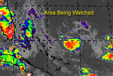
East of the Bahama islands, there is an area of storms... a trough of low pressure. on the surface. Right now upper level winds are keeping any potential development down, but the area looks like it could calm a bit.
There is a chance for development and it could become a depression before Friday.
If it did, and this is important, chances are that it would veer eventually to the northwest and then north and miss the coast of the United States completely. However, as always, this should be watched to see if it continues to show signs of wanting to become a tropical depression.
Develoment Potential scale
Code:
forget it) 0 1 2 3 4 5 6 7 8 9 10 (sure thing)

            [------*---------------]
Since it hasn't reached invest status, and still could fall apart, it'll just be watched at the moment.
General Links
NRL Monterey Marine Meteorology Division Forecast Track of Active Systems (Good Forecast Track Graphic and Satellite Photos)
Check the Storm Forum from time to time for comments on any new developing system.
Follow worldwide SST evolution here:
Global SST Animation
NASA GHCC Interactive Satellite images at:
North Atlantic Visible (Daytime Only), Infrared, Water Vapor
Some forecast models:
NGM, AVN, MRF, ETA ECMWF
DoD Weather Models (NOGAPS, AVN, MRF)
Multi-model plots from WREL
Other commentary at Mike Anderson's East Coast Tropical Weather Center, Independentwx.com, Robert Lightbown/Crown Weather Tropical Update Accuweather's Joe Bastardi (now subcriber only unfortunately), Cyclomax (Rich B.), Hurricane City , mpittweather , Tropical Weather Watchers.Com (JasonM) Gary Gray's Millennium Weather, Barometer Bob's Hurricane Hollow, Snonut,
Even more on the links page.
| Old Sailor |
| (Storm Tracker) |
| Wed Jul 28 2004 02:33 AM |

|
|
|
This area of thunder storms with a trough of low pressure on surface or mid level has a better chance ot become a TD/ TS maybe on my 75th Birthday 8/01. Upper level winds are keeping the system in check right now but as wind shear drops , then maybe have first TS.
| Steve |
| (Senior Storm Chaser) |
| Wed Jul 28 2004 02:50 AM |

|
|
|
Killer. All the best on the diamond birthday OS.
Steve
| James88 |
| (Weather Master) |
| Wed Jul 28 2004 10:56 AM |

|
|
|
The activity in the Bahamas isn't doing that much at the moment, but the shear will probably decrease eventually. Even without much development possible in the immediate future, the ETA has closed off a surface low in the eastern GOM for two runs in a row now, so that could be somewhere to watch this weekend.
| LoisCane |
| (Veteran Storm Chaser) |
| Wed Jul 28 2004 11:37 AM |

|
|
|
Well...is there or isn't there?
Maybe Atlantis will rise from the tropical dance of entities stuck in lazy steering currents?
No Hank...this is going to be short, promise

Seriously, looking at the water vapor loop and well it doesnt really sing to me, got to tell you. Not convinced of much on this one. If there is something in there..its playing possum (that is a proper redneck spelling btw) and I don't see it .. not now.
Will keep watching today to see if you see anything worth paying attention.. hoping ed gets his 7/31 wish and if not maybe old sailor could have a storm named after him on 8/1
Either way.. I hope I won't be off topic if I wish him a happy birthday then. 75 is a great sounding age, have to tell u.. so hang on sailor, sailor hang on.. we got partying to do
have a good day guys, nope..not obsessing too much
and personally like the morning TWO from NHC, think its as close to map as they have ever written.
Phil.. hope you are feeling better..
| James88 |
| (Weather Master) |
| Wed Jul 28 2004 12:46 PM |
|
|
|
|
Looks like there's a bit of a flare up going on several hundred miles east of the Bahamas. Maybe we should watch there for today.
I was just looking through some archives through sheer boredom, and I couldn't help but notice that July 28th is normally a quiet day in the Atlantic basin. Out of the last 55 years, only 13 have had a tropical system on this date.
1954 - T.S. Barbara south of Louisiana
1959 - T.D. Debra over the central U.S.
1960 - T.D. 3 in E. GOM
1964 - T.D. 2 in C. Atlantic
1966 - Hurricane Dorothy in the C. Atlantic
- Tropical Storm Ella north of P.R.
1969 - Tropical Storm Anna in the C. Atlantic
1975 - Hurricane Blanche heading toward Nova Scotia
1976 - T.D. 2 in the C. Atlantic
1979 - T.D. Claudette over the central U.S.
1990 - Tropical Storm Bertha off the Carolinas
1995 - T.D. 4 in the E. GOM
1996 - Hurricane Cesar making landfall over Nicaragua
1998 - T.D. 1 in the E. Atlantic
There, that took up some time. Looks like the dry streak in the tropics will continue.
Are you getting much rain up in Long Island, Phil? You said you could expect 36 hours worth, yesterday.

And finally - Old Sailor, have a great birthday on Sunday!

| Cycloneye |
| (Storm Tracker) |
| Wed Jul 28 2004 01:04 PM |
|
|
http://cimss.ssec.wisc.edu/tropic/real-time/wavetrak/winds/wavetrkAsal.jpg
Interesting that the SAL is not as strong as before and that may signal more moist air meaning better conditions just in time as august arrives and more as MJO spills into the atlantic by mid august.
| doug |
| (Weather Analyst) |
| Wed Jul 28 2004 01:35 PM |
|
|
Yes...that whole area is very interesting. If that were located at 55w and not 65w we probably would already be looking at an organized system...Anybody have any ideas on when that ULL nw of the system will pull out and where it will go? If the proxmity between them does not ease a lot then I give this LOW marks for further development. On the other hand IF that ULL pulls out and the trough eases then this may go..it has a good intrained moisture flow from the SE which should enhance development.
| Steve |
| (Senior Storm Chaser) |
| Wed Jul 28 2004 01:52 PM |
|
|
|
|
It's a watch and see game Doug. Usually those things move off to the W, WSW or SW at this time of year. But who really knows?
I don't have a bookmark of the ENSO model outputs at work, but almost all of them have backed off in the July report (both 3 month and 8 month ranges) from warm to remaining neutral. SST's in the basin are warming off the NE coast as per the last couple of years. If it remains look for some New England/Canada activity down the line. If it gets beat down, don't look for as much.
It's a watch day.
Steve
| Unregistered User |
| (Unregistered) |
| Wed Jul 28 2004 01:57 PM |
|
|
Yup, agree with you all here. It's a real "iffy" day.. great statistics for the day in history..where do you get those facts from?
always amazes me how Miami was rebuilt after the 26 storm, a tough beautiful always evolving city
bobbi
| James88 |
| (Weather Master) |
| Wed Jul 28 2004 02:11 PM |
|
|
|
|
I got the statistics for July 28th from Unisys. Here's a link if you don't know it:
Unisys hurricane archives
The Bahamas system is looking really interesting now. We'll obviously have to keep a close eye on this one.
| Steve |
| (Senior Storm Chaser) |
| Wed Jul 28 2004 02:45 PM |
|
|
|
|
Things to watch from this morning's Global model runs:
AVN Loop 06Z - Puts a low pressure on the Gulf side of Florida and moves it in similar to an inverted trof into LA/MS/AL as the Bermuda High retrogrades into the coast. It also is pretty strong on the Central Atlantic after 5 days.
CMC 00Z - Develops perhaps a depression and moves it into South Carolina while dropping an upper impulse down SW through the Gulf and into the BOC.
Navy NOGAPS 00Z - Develops a low in the Eastern Gulf and brings it in between New Orleans and Pensacola.
UK Met 00Z - Moves an impulse up to the coast of the Carolinas and a fairly substantial wave across the Northern Gulf into Texas at the end of the run period.
European/ECMWF - Likes a similar solution to the UK Met with a piece heading off to the Mid Atlantic and disturbed weather in the Gulf heading off toward Texas.
All in all, there doesn't seem to be anything major afoot. But it wouldn't be impossible to have a couple of invests up by Saturday.
Steve
| James88 |
| (Weather Master) |
| Wed Jul 28 2004 03:39 PM |
|
|
|
|
Well, regardless of whether anything develops or not, these runs just serve to highlight the fact that the time is near for Alex to form. Thanks for posting them, Steve.
 BTW, anyone noticed the 3 impressive systems currently over Africa? Maybe they'll have some potential when they emerge into the Atlantic. Even if they don't form, every passing wave lowers the pressure and provides more moisture to aid the development of the wave behind it. It does seem to be shaping up for an active CV season.
| rmbjoe1954 |
| (Weather Master) |
| Wed Jul 28 2004 03:44 PM |

|
|
|
Tropical Weather Outlook
Statement as of 11:30 am EDT on July 28, 2004
For the North Atlantic...Caribbean Sea and the Gulf of Mexico...
Disorganized cloudiness and thunderstorms extending from Florida
estward across the Bahamas and the Atlantic are primarily
associated with an upper-level trough. This activity is expected to
spread slowly toward the west-northwest. Surface pressures remain
high and upper-level winds are not favorable for development.
Elsewhere...tropical storm formation is not expected through
Thursday.
Forecaster Avila
$$
This may be one of the last 'shooting blanks' statements from NOAA we may see for a while.
| Unregistered User |
| (Unregistered) |
| Wed Jul 28 2004 04:10 PM |
|
|
Think its a good call. Way to messy out there for much to form. Not now anyway. Saturday is a long ways away.
Maybe that old Dyno-mite company should start seeding those clouds with Viagra, might perk up the season so to speak.
(short post HF) cute joe
| Old Sailor |
| (Storm Tracker) |
| Wed Jul 28 2004 04:49 PM |
|
|
|
|
Thanks Steve, for B'day wish, but the area doesn't look so good today, last night looked a lot better, but wait and see what happens.
Dave
| Unregistered User |
| (Unregistered) |
| Wed Jul 28 2004 05:12 PM |
|
|
alot of areas bout ready to roll off africa.
| Rob_M |
| (Weather Hobbyist) |
| Wed Jul 28 2004 06:42 PM |

|
|
|
Unless the E GOM or W ATL areas pull a fast one, it looks like we'll end Jul with no TCs. Not to worry...the time will come. Perhaps sooner rather than later. Here's our latest discussion FWIW...
IWIC Atlantic Tropical Weather Discussion - 28 July 2004 - 1:20 PM EDT
For the most part, weather in the tropical Atlantic remains quiet. There are a few areas worth mentioning, however. Firstly, a strong upper level cyclone and associated surface trough are generating scattered convection from the Bahamas to 60ºW by strong diffluence. This disturbance has changed little over the past 24 hours and remains poorly organized. The only model that shows development of this system is the CMC. Considering that no other model is in agreement, plus the CMC's recent bias to over-amplifying lows in the subtropics, it is probably wise to disregard this solution. The entire model guidance indicates an upper level ridge will build over the Gulf of Mexico behind the current trough exiting the United States east coast in the next 2 to 3 days. Strong southerly shear over the western Atlantic will thus be enhanced and hinder any barotropic intensification from this system.
Another area worth watching is a weak area of convection along the remnants of a old frontal boundary in the eastern Gulf of Mexico. At the moment there is no low level center, but global model guidance does show increased low level cyclonic flow from this system over the next few days. A possible reason is the ridging progged to settle in the Gulf of Mexico as mentioned above. This will reduce shear values and aid evacuation aloft. Where any potential low will track is still in question, as models are a bit more diverged. Some lean towards a quasi-stationary motion in the eastern Gulf of Mexico, such as the GFS, whereas others take a possible low further west, such as the UKMET. Despite the favorable upper environment that may set in place, a classified tropical cyclone is still far-fetched at this point. The main reason being that, under normal circumstances, it will take more than a few days for a poorly organized area of showers along the tail of an old frontal boundary to organize into a strong enough low level pressure system. It will be an area to keep an eye on, but no tropical development is expected at this time.
In the Mean Development Region, Saharan Air and subsidence are suppressing the Intertropical Convergence Zone and traversing tropical waves. However, a high-amplitude tropical wave that just exited the western African coast will help clear the stable environment in place. Furthermore, over the African continent just north of the equator, several concentrated areas of convection have formed, possibly signalling the beginning of a tropical wave train. The operational GFS has now developed a tropical cyclone in the eastern Atlantic late in the forecast period for the past 5 runs, probably from one of these areas of convection over Africa. Although there is currently no support from other global models, this bears watching given the gradually improving Mean Development Region environment and the consistency in the GFS. To top all of that off, a dry Madden-Julian Oscillation that currently resides in the Atlantic Basin will move out of the area and be replaced by a wet phase by the middle of the upcoming month. So whether the exact tropical wave develops as the GFS shows or not, all indications point towards a significant increase in deep Atlantic tropical cyclone activity over the coming weeks as the peak of the season draws closer.
| Cycloneye |
| (Storm Tracker) |
| Wed Jul 28 2004 07:11 PM |
|
|
Rob a question despite the no storm formations in july.Will the independent group leave the numbers the same 14/8/4 or some minor changes will happen with your outlook? I agree that everything is comming into place just as the heart of the season draws closer.
| doug |
| (Weather Analyst) |
| Wed Jul 28 2004 07:26 PM |
|
|
Florida weather for the past several days has been suspiciously awful, and contrary to assertions overall the barometers are relatively low due to the proxmity of all the thunderstorm activity.
today howevr a change is occurring in the motion of the showers to a sw drift. If you look at a loop of rainfall in the florida straits you will see a cyclonic motion probably indicating where the trough axis actually is. I sense that some type of surface feature may start to dig down there.
Steering currents over this area are weak indicating no real upper level shear.
If there is to be development in the E. Gom it will begin in this feature as it drifts wnw
no science here, just what my eyes and senses are telling me...not predicting just relaying observations.
| Unregistered User |
| (Unregistered) |
| Wed Jul 28 2004 07:47 PM |
|
|
beautiful, good job .. really
sort of painted a whole picture of the Atlantic
thanks
| Unregistered User |
| (Unregistered) |
| Wed Jul 28 2004 08:00 PM |
|
|
(off-topic post)
| Rabbit |
| (Weather Master) |
| Wed Jul 28 2004 08:41 PM |

|
|
|
First off, I think politics kept 98L from being classified--NHC didn't want to scare people with a TD or TS during the DNC in Mass.
now for my analysis of the forecast models
first off, I see nothing on the ECMWF over the Gulf that catches my eye, and that particular model has a history of inaccuracy in recent years (example, weakening Isabel after three days last year on the Sep 7 run)
the UKMET, which is also rather unreliable, shows a weak low in the Gulf
the NOGAPS, which is moderately accurate, shows a very broad low in the Gulf in a few days, but weakens it
the CMC, a somewhat reliable model, shows a possible TD near SC, which everyone else seems to have seen also. I think it is possible in a few days, and may be like TD2 in 1994 (formed from a front, pressure at 1015 at landfall on July 20)
the AVN, which seems to be the most reliable, still shows something comming off of Africa in about 4 days, but nothing in the Gulf. Interestingly, the African low is forecast to be rather compact and organized by August 2, with pressure between 1004 and 1006. It has held with this forecast for a week now, and a "blocker" wave has come off of Africa, blocking the high pressure and forcing it north, and may lower the pressure enough in the eastern Atlantic for the next wave to survive and strengthen.
| Steve |
| (Senior Storm Chaser) |
| Wed Jul 28 2004 09:15 PM |
|
|
|
|
I'ma take issue with your analysis of the models Rabbit. Go to Google and search "known biases of forecast models" for the real story. Saying the UKMet and ECMWF are "unreliable", but that the AVN and NOGAPS are (or moderately are) is out there. Some of the models may perform better than others in certain circumstances, and everyone has their preferences. But what you posted is not accurate. (No harm no foul IMHO.)
Steve
| Unregistered User |
| (Unregistered) |
| Wed Jul 28 2004 09:30 PM |
|
|
WHoah ho' thar! The UKMET and EC unreliable?........I don't think so. They are excellent models for picking up large scale patterns, and quite serious when they bark. NOGAPS throws a right bias into everything and really so does the GFS, along with the convective feedback problems it has had (and alledgedly fixed). AVN/GFS is notorious for spurious lows in the tropics as well. All models have their flaws/biases for sure, but have their strengths as well. Read some of the EPCs thought processes for insight, since they use the models to validate/blend/discount solutions every day. These discussions are great for learning and identifying when particular models are exhibiting their biases and when they are dead on in a given situation. Remember that models are tools. We need to learn the biases in order to use them properly
| Unregistered User |
| (Unregistered) |
| Wed Jul 28 2004 09:31 PM |
|
|
Anybody see what JB has to say today? He's probably in heaven right now with all the models spittin tropical lows around everywhere. I know he loves it
| DroopGB31 |
| (Weather Guru) |
| Wed Jul 28 2004 09:38 PM |
|
|
Oops, that last post was me, I got excited and forgot to sign in. By the way, do ya'll think its worth the money to sign up for AccuPro? Im thinking about so I dont have to keep beggin to see what JB says lol Have a good one ya'll.
| Steve |
| (Senior Storm Chaser) |
| Wed Jul 28 2004 09:41 PM |
|
|
|
|
Agreed SteveH. The main problem I have with the ECMWF is that it tends to bias southward waves that it doesn't believe are going to develop. Sometimes it's an outiler, but often it is correct. I trust it more for overall pattern stuff (and the UKMet before I would trust the AVN/GFS suite and certainly more than NOGAPS). The biggest problem with GFS is it's inability to factor warm water in the Western Atlantic always wanting to drop a trof off the east coast in Days 10-15 - also the related convective feedback problem you alluded to.
Anony,
Nothing earth shattering on Joe this morning. I went and checked him out after I posted and he just said that he's watching too and expressed a few concerns.
Steve
| Steve |
| (Senior Storm Chaser) |
| Wed Jul 28 2004 09:45 PM |
|
|
|
|
Droop,
Sign up for the 30 day free trial and see for yourself. I only keep it between June and October and they don't have a problem with that. They understand that some people don't really care about winter weather (this guy) as it doesn't really have any major effects on them. But if you give your information, you can cancel within 30 days and they'll never charge your credit card. This is my second year of doing it and I plan to carry the service again next year unless we're in some raging El Nino or whatever.
Steve
| DroopGB31 |
| (Weather Guru) |
| Wed Jul 28 2004 09:46 PM |
|
|
Has anyone saw the newest TWO? It says theres a weak area of low pressure of the FL penisula and conditions appear favorable for development in the Eastern Gulf. Intresting, those models may be on to something.
| DroopGB31 |
| (Weather Guru) |
| Wed Jul 28 2004 09:50 PM |
|
|
By the way, thanks for the advice Steve. Sounds like a good idea.
| Rich B |
| (British Meteorologist) |
| Wed Jul 28 2004 09:51 PM |
|
|
Hey droop,
yeah i noticed that too. This could possibly be related to the circulation that was apparent south of Andros Island yesterday. If that circulation has persisted in some form and travelled west then it would tie up with the location of the weak low that the TWO alluded to. If i remember rightly some models have been hinting at something in this region for a few days now too. The NHC have changed their tune a little from the 1130 TWO which said development wasnt expected. However, no invest up yet so nothing imminent i guess.
Regards
| DroopGB31 |
| (Weather Guru) |
| Wed Jul 28 2004 10:01 PM |
|
|
Yep Rich, Nothing Imminent, something to watch though. The ETA has had a closed low in the eastern gulf for quite a few runs now. I looked at a few other models and they had the same idea. Have to wait and see.
| HanKFranK |
| (User) |
| Wed Jul 28 2004 10:05 PM |

|
|
|
there's an awful lot of low level convergence near the florida peninsula. notice that low cloud motions in the gulf are from the west, while in the atlantic they're out of the east to the decaying trough oriented nne from the bahamas. several models are alluding to disturbed weather there, but none are really taking off. i have to admit that upper conditions are decidedly neutral, with no real evacuation mechanism in place for convective growth.. unless an outflow jet from whatever thunderstorm activity near south florida were to hook into the nearby upper flow.
away east the disturbance between hispaniola and bermuda looks about like yesterday. not making any hay right now.. the trades are blasting away underneath the upper low and it's corresponding convection enhancement area and will have to subside some before anything can get started there.. closer in as the trough remnants near the bahamas to off hatteras decay they could potentially spawn something else along the lines of erstwhile 98L.
the MDR out in the east atlantic has nothing on the burner. only other thing of interest to me is that the trades are weaker at low latitudes in the caribbean and the itcz is inching northward near panama.. nothing progged on the models but something could try to sneak in down there next few days. end of the month gfs has yet another good wave coming off africa. it's hinting at development and has been with some consistency, so it will at least be worth watching.
that's the story. nothing is happening just yet.
HF 2205z28july
| Unregistered User |
| (Unregistered) |
| Wed Jul 28 2004 10:05 PM |
|
|
spin this loop.. set it to faster.. FASTER
do not try this alone, you will become hypnotized, careful
be warned
but you can sure see the movement of systems/steering currents
http://www.cira.colostate.edu/RAMM/Rmsdsol/TROPICAL.html
| LI Phil |
| (User) |
| Wed Jul 28 2004 11:12 PM |

|
|
|
E'en all. Still sick. Can't add too much to the tropical discussion, and haven't been online all day, so I'll leave it with this: TWC said watch the GOM for development in the next couple of days. I s'pose a blind squirrel finds an acorn every so often, so they could be right. But the time is drawing neigh for the real action to happen, so as steve said it's wait and watch time (or was that watch and wait?).
HF, obviously your spelling admonitions have gone for naught. Such a simple word, too.
Accuwx pro is da bomb! And not just for Joe B (although it'd be worth is just for his commentary). I'll be keeping it year round as winterwx up here is something I need to keep on top of. Agree w/Steve-o, try it free for 30 days. But you'll be keeping it for the whole season...I gar-ohn-tee it.
What else? Guess the mess east of the Bahamas needs to be watched. Glad Rob/Jason are back posting. Bobbi, sorry you got wet -- isn't there some law you have to carry an umbrella in South Fla in the summer? And I guess the nepalese thingy worked, because now they have their worst floods in something like 10 years. James88, didn't get any rain today, but got dumped on last night, with a beautiful light show thrown in.
Guess das it fo' now. Depending on how I feel, I may go check some loops & models. Either way, I'll check in again.
LI Phil
| Rob_M |
| (Weather Hobbyist) |
| Wed Jul 28 2004 11:19 PM |
|
|
|
|
Quote:We're keeping 14/8/4...no reason to lower.
Rob a question despite the no storm formations in july.Will the independent group leave the numbers the same 14/8/4 or some minor changes will happen with your outlook? I agree that everything is comming into place just as the heart of the season draws closer.
| Unregistered User |
| (Unregistered) |
| Thu Jul 29 2004 12:02 AM |
|
|
no... no law and i hate carrying them
warm rain
dont see that this is going to develop but then it probably will as im always wrong with gulf systems
twc tonight insists we are getting more rain tomorrow and they seem to be bullish on the idea of a depression forming in the SE Gulf than around this room
odd to see Steve bullish on tropical development
anyway...feel better phil, wish i could make you feel better
and keep watching.. who knows
Bobbi
| LI Phil |
| (User) |
| Thu Jul 29 2004 12:15 AM |
|
|
|
|
(off-topic nuked at 10:40pm - lousy forecast)
Can we please get something going in the tropix? I mean, c'mon. No TD even (although several on this board, myself included, would beg to differ).
Oh well, August 1 (and Old Sailor Dave's Diamond Jubliee) will be here Sunday. Pretty much guaranteed of some action after then...
Cheers,
LI Phil
| Old Sailor |
| (Storm Tracker) |
| Thu Jul 29 2004 12:31 AM |
|
|
|
|
You know Guys, Girls,
I said August 1 my birthday more as joke but it may end up in my back yard on St. Pete beach, Old saying be carefull of what you wish for, Just need to watch the low north of Tampa Bay and other low in south FL moving west . Models not sure when or where this low is drifting too... It is in a favorable area.
Dave
| DustDuchess |
| (Weather Watcher) |
| Thu Jul 29 2004 12:45 AM |
|
|
Regarding TWC being Bullish on the SE possible weather, would it possibly be that they are suffering from a ratings drop with no tropical storms to report on besides old film footage and too much national competition for political events? This is a serious question and needs pondering for when complacency issues plague real evacuation attempts. Those weather systems that appear to be forming near and around South Florida may only be labor pains of an on-time tropical season, but the systems are so close that the shortest distance between a deadly weekend of unexpected storm and the official report is the Cable weather channels. Hopefully those two little wannabees will be all wet and no problem to land.
|
Ed Dunham
|
| (Former Meteorologist & CFHC Forum Moderator (Ed Passed Away on May 14, 2017)) |
| Thu Jul 29 2004 02:55 AM |
|
|
The fun is over - stay on topic.
Use the Everything & Nothing forum for your political commentary. I believe its well suited to the 'Nothing' part of that Forum.

Keep in mind that someone's good post always gets lost in the shuffle when you do this.
ED
|
Ed Dunham
|
| (Former Meteorologist & CFHC Forum Moderator (Ed Passed Away on May 14, 2017)) |
| Thu Jul 29 2004 03:02 AM |
|
|
From: WXMAN RICHIE
Hi All,
I am back for another exciting year. I have been away for most of the summer, but I haven't missed much so far. Now that I am back, the season will begin. August 1st is just around the corner and I think the season is just about ready to kick in. Looks like the gulf just to the west of Key West is the place to watch for the next day or so.
| James88 |
| (Weather Master) |
| Thu Jul 29 2004 10:05 AM |
|
|
|
|
The latest TWO sites two areas for potential development:-
SHOWERS AND THUNDERSTORMS OVER THE FLORIDA PENINSULA AND ADJACENT
WATERS ARE ASSOCIATED WITH A BROAD AREA OF LOW PRESSURE LOCATED OFF
THE SOUTHWESTERN FLORIDA COAST. UPPER-LEVEL WINDS ARE CURRENTLY
ONLY MARGINALLY FAVORABLE...BUT SOME SLOW DEVELOPMENT OF THIS
SYSTEM IS POSSIBLE OVER THE NEXT COUPLE OF DAYS AS IT DRIFTS
WESTWARD INTO THE EASTERN GULF OF MEXICO.
WIDESPREAD SHOWERS AND THUNDERSTORMS HAVE BECOME A LITTLE MORE
CONCENTRATED THIS MORNING ABOUT 500 MILES EAST OF THE CENTRAL
BAHAMAS. THIS ACTIVITY IS ASSOCIATED WITH AN UPPER-LEVEL LOW
INTERACTING WITH A SURFACE LOW PRESSURE TROUGH. UPPER-LEVEL WINDS
ARE GRADUALLY BECOMING A LITTLE MORE FAVORABLE OVER THE AREA...AND
SOME ADDITIONAL ORGANIZATION IS POSSIBLE DURING THE NEXT COUPLE OF
DAYS AS THE SYSTEM MOVES WEST-NORTHWESTWARD AT 5 TO 10 MPH.
The system east of the Bahamas looks like it is becoming better organised, so it would seem to be the area to watch. Could this be the system that the CMC model wants to take into South Carolina?
| Rich B |
| (British Meteorologist) |
| Thu Jul 29 2004 10:33 AM |
|
|
Well will we get to August 1st without a named system? Quite possibly. But will we get to August 1st without a classified system? Well that is a whole different question!
The first possible system is the one that has tracked slowly from the Bahamas and is now over the Florida Peninsula, heading slowly towards the eastern Gulf. This is a poorly organised system, with only marginal upper-level support at this time. Its proximity to land could also inhibit any significant development, at least for the next 24 hours.
The second area, and the one with higher possibilities, is the area of disturbed weather east of the Bahamas. This region has seen disturbed weather persisting for days now. As the TWO states, and recent satellite imagery shows, this area is becoming a little better organised. Again, upper-level conditions arent that great, but are slowly improving. Tie the slowly improving upper level conditions with the corresponding organisation, and it looks like we could see something develop from this, possibly even before 1st August.
| LoisCane |
| (Veteran Storm Chaser) |
| Thu Jul 29 2004 11:09 AM |
|
|
|
|
Miami tv insists the system is "stalled out" and pumping up massive amounts of water.
Is the system stalled out?
Want your opinon here.
Tons of rain but don't see any wind, not even during the rain.
Almost reminds me of Fall rain when the fronts stall out and don't make it down all the way.
Bobbi
| James88 |
| (Weather Master) |
| Thu Jul 29 2004 11:23 AM |
|
|
|
|
The system east of the Bahamas looks like it may have a little spin to it, and it kinda looks like Danny did last year before he formed. I wouldn't be surprised to see an invest in the near future.
| LoisCane |
| (Veteran Storm Chaser) |
| Thu Jul 29 2004 11:40 AM |
|
|
|
|
Can both form?
Bahamas and Gulf?
nice rainbow in miami..it lies...gonna rain some more
am sure
| James88 |
| (Weather Master) |
| Thu Jul 29 2004 11:51 AM |
|
|
|
|
The Gulf system could form, but since the upper level winds are only marginally favourable at the moment, I wouldn't expect anything in the immediate future. Maybe in a couple of days. The Bahamas system meanwhile looks to have good potential to develop based on the TWO and its current appearance on satellite imagery. Whatever happens this is probably our best and last chance to get a classified system before August sets in.
| rmbjoe1954 |
| (Weather Master) |
| Thu Jul 29 2004 12:46 PM |
|
|
|
|
I've seen on TV News 12 that this Bahamian system will move WNW and the 'arrow' indicated an East central Florida hit; isn't it too soon to extrapolate a pathway?
Anyhow I agree that this may become a South Carolinian issue down the road as these storms would normally be routed in that direction.
Just a guess at this point.
| Cycloneye |
| (Storm Tracker) |
| Thu Jul 29 2004 12:52 PM |
|
|
http://tcweb.fnmoc.navy.mil/tc-bin/tc_home.cgi
Ok here we go with this area that has potential so let's see what happens in coming days.
| Unregistered User |
| (Unregistered) |
| Thu Jul 29 2004 01:00 PM |
|
|
I'm not sure of the strength of the ridging to the north of Invest 99L. East central Florida generally does not see systems this far north hit them. They usually head for the Carolinas. However, this is the time of year when we have to watch the Bermuda high, and its strength. First lets see when they put coordinates. I'm figuring about 24.8N/70.5 W. Interesting..........

| doug |
| (Weather Analyst) |
| Thu Jul 29 2004 01:02 PM |
|
|
Since I first noted the Florida straits low yesterday afternoon, it seems, just from radar, that the low has actually moved about 100 miles west and is now centered over Key West. Radar confirms, to me at least, that it is a closed low; but development is being inhibited by the upper feature. This will all change, IMO in a day or so as ridging should appear in the lower gulf coast which could support development. I would agree with the NHC that the next 48 hours will tell with this.
The Bahamas system may go sooner, as it seems ready to rotate out over the influence of the upper low which was two days ago to its NW and now seems about to play it self out to its SW. This should continue generally toward the SC coast, and I think will be picked up in two-three days by the trough in the midwest now.
This same trough will create the ridging over the GOM during that same period and influence th development and future of that system too.
My guess: both get classified, Bahamas first with the GOM system a landfalling TS Monday or Tuesday, and the Bahamas system goes to sea.
We'll see!
| James88 |
| (Weather Master) |
| Thu Jul 29 2004 01:08 PM |
|
|
|
|
So perhaps we'll have Alex and Bonnie within a week! I think that newly upgraded 99L has a very good chance at development, and it should be watched closely. Just my opinion. The next TWO will give us a better idea of the situation.
| Unregistered User |
| (Unregistered) |
| Thu Jul 29 2004 01:20 PM |
|
|
CHGHUR
DISCLAIMER...NUMERICAL MODELS ARE SUBJECT TO LARGE ERRORS.
PLEASE REFER TO TPC/NHC OFFICIAL FORECASTS FOR TROPICAL CYCLONES.
.....THE FOLLOWING IS A TEST MESSAGE.....
NATIONAL HURRICANE CENTER NORTH ATLANTIC OBJECTIVE AIDS FOR
TROPICAL DEPRESSION INVEST (AL992004) ON 20040729 1200 UTC
...00 HRS... ...12 HRS... ...24 HRS... ...36 HRS...
040729 1200 040730 0000 040730 1200 040731 0000
LAT LON LAT LON LAT LON LAT LON
BAMD 25.0N 71.0W 25.8N 72.4W 26.7N 74.0W 27.7N 75.7W
BAMM 25.0N 71.0W 25.9N 72.9W 27.0N 74.7W 28.1N 76.7W
A98E 25.0N 71.0W 25.5N 73.2W 26.2N 74.9W 27.4N 76.3W
LBAR 25.0N 71.0W 25.9N 72.9W 27.1N 74.6W 28.2N 76.4W
SHIP 25KTS 32KTS 40KTS 47KTS
DSHP 25KTS 32KTS 40KTS 47KTS
...48 HRS... ...72 HRS... ...96 HRS... ..120 HRS...
040731 1200 040801 1200 040802 1200 040803 1200
LAT LON LAT LON LAT LON LAT LON
BAMD 28.6N 77.5W 30.0N 80.2W 31.0N 81.6W 34.3N 78.4W
BAMM 29.3N 78.7W 31.6N 81.5W 34.6N 81.9W 37.8N 76.9W
A98E 28.7N 77.9W 30.7N 80.8W 32.6N 81.2W 36.2N 75.1W
LBAR 29.7N 78.1W 32.1N 79.5W 34.5N 78.5W 35.9N 73.8W
SHIP 52KTS 56KTS 59KTS 60KTS
DSHP 52KTS 46KTS 29KTS 27KTS
...INITIAL CONDITIONS...
LATCUR = 25.0N LONCUR = 71.0W DIRCUR = 280DEG SPDCUR = 12KT
LATM12 = 24.5N LONM12 = 68.2W DIRM12 = 281DEG SPDM12 = 14KT
LATM24 = 24.0N LONM24 = 65.0W
WNDCUR = 25KT RMAXWD = 0NM WNDM12 = 20KT
CENPRS = 1009MB OUTPRS = 1010MB OUTRAD = 150NM SDEPTH = D
RD34NE = 0NM RD34SE = 0NM RD34SW = 0NM RD34NW = 0NM
.....THE ABOVE HAS BEEN A TEST MESSAGE.....
| James88 |
| (Weather Master) |
| Thu Jul 29 2004 02:15 PM |
|
|
|
|
Has Joe B. got anything to say on 99L or the system in the GOM?
| LI Phil |
| (User) |
| Thu Jul 29 2004 02:25 PM |
|
|
|
|
Back at work, still feelin' low. Here's from JB real quick:
TROPICAL TROUBLES LURK FOR COASTAL CAROLINAS THIS WEEKEND AND GULF COAST WEST OF 90 WEST EARLY NEXT WEEK.
| Unregistered User |
| (Unregistered) |
| Thu Jul 29 2004 02:39 PM |
|
|
90L invest up for SE Gulf
http://www.nrlmry.navy.mil/tc-bin/tc_hom...-EPAC-05E.DARBY,04-EPAC-06E.NONAME,04-WPAC-13W.NAMTHEUN,04-ATL-90L.INVEST,04-ATL-99L.INVEST,&STYLE=tables
| Cycloneye |
| (Storm Tracker) |
| Thu Jul 29 2004 02:45 PM |
|
|
http://www.nrlmry.navy.mil/tc_pages/tc_home.html
Here is the more smaller link for 90L.
| teal61 |
| (Weather Hobbyist) |
| Thu Jul 29 2004 02:45 PM |
|
|
From some of the AFD's in Florida.....
FLORIDA KEYS AREA FORECAST DISCUSSION
NATIONAL WEATHER SERVICE KEY WEST FL
950 AM EDT THU JUL 29 2004
.DISCUSSION...
.OBSERVATIONS/TRENDS...
MORNING SOUNDINGS AT KEY WEST AND MIAMI VERIFIED A VERY WET TROPICAL
AIRMASS IN PLACE OVER THE REGION...WITH PRECIPITABLE WATER VALUES
QUITE HIGH AT 2.4 TO 2.5 INCHES. K-INDEX VALUE WAS HIGH AT 39.
CURRENT RADAR TRENDS ARE INTERESTING WITH REGARD TO CELL MOVEMENT...
SUGGESTING A CYCLONIC CENTER NOW NEAR BIG PINE KEY. NEWLY DEVELOPING
SHOWERS/TSTMS EAST OF THERE ARE NOW MOVING TOWARD THE NW...WHILE
WEST OF THERE MOTION REMAINS GENERALLY TOWARD THE S OR SW. THIS
CYCLONIC SPIN...HOWEVER...IS ALOFT AND APPEARS TO BE TRANSLATING
WESTWARD. MEANWHILE...SURFACE PRESSURE AND WIND PATTERN AT THIS TIME
INDICATES A BROAD ILL-DEFINED LOW PRESSURE AREA WEST OF THE KEYS.
KEYS SURFACE WINDS HAVE TURNED TO SE NEAR 10 KT OVER UPPER KEYS
AREAS...ARE LIGHT S TO SW OVER LOWER KEYS...BUT AGAIN REMAIN
AFFECTED BY SHOWERS AND THUNDERSTORMS.
.FORECASTS...
INTERMEDIATE ETA RUN (06Z) HAS DISPLACED ITS FORECASTED SURFACE LOW
PRESSURE DEVELOPMENT A BIT FARTHER SOUTH THAN BEFORE...SHOWING A
WEAK LOW SOUTH OF DRY TORTUGAS BY 8 PM THIS EVENING...WHILE GFS IN
CONSISTENT WITH EARLIER RUNS SHOWING A WEAK LOW CENTER WEST OF DRY
TORTUGAS IN THE GULF. CURRENT WIND TRENDS WOULD SEEM TO FAVOR THE
GFS SOLUTION...BUT THE OVERALL SCENE STILL IS ONE OF A SLOWLY
DEVELOPING LOWER PRESSURE OVER THE SE GULF...AND A WET PATTERN OVER
THE KEYS. NO UPDATE TO PUBLIC ZONES IS ANTICIPATED...WITH HIGH
CHANCE OF RAIN TODAY. CURRENT RADAR TRENDS SUGGEST SMALL CLUSTERS
AND LINES ARE FORMING IN THE DEEPER SE TO S FLOW...WHICH COULD BRING
THE ANTICIPATED HEAVIER RAINFALL AMOUNTS FROM THE STRAITS INTO THE
KEYS.
SOUTH FLORIDA FORECAST DISCUSSION
NATIONAL WEATHER SERVICE MIAMI FL
1000 AM EDT THU JUL 29 2004
.UPDATE...LATEST SURFACE ANALYSIS SHOWS BROAD AREA OF LOW PRESSURE
ACROSS EASTERN GULF WITH WEAK LOW BEGINNING TO TAKE PLACE ACROSS SE
SECTIONS OF THE GULF AND A WEAK TROUGH EXTENDING INTO THE SW FL
COAST. AT LOW LVLS...850 AND 700 MB...12Z ANALYSIS SHOW TROPICAL
WAVE/TROUGH JUST OFFSHORE SW GULF COAST...NAPLES...STRETCHING SE
INTO THE FL STRAITS.
A look at the visuals this morning seems to show some broad rotation in the vicinity of the Florida keys, and now with the new invest 90L up thing are getting a little more interesting.
| joepub1 |
| (Storm Tracker) |
| Thu Jul 29 2004 03:10 PM |
|
|
Now we're talking tropics. Signs are the doors are about to swing open for the season. 90L and 99L are up, with 99L looking better at the moment.It may have some impact on north FL weather by the weekend, although NWS/Jax is not reflecting that in it's forecast yet. Clouds not showing signs of alot of shear, and begining to gather around possible center. Cool! Let's go Alex, this is you.......
90L is a bit more of a long term project, going to take some time if this baby is to get going. If it does, NO to PEN would be my guess as to who might see it, though I saw a model somewhere take it further west. Still a couple of days away, IMO.
Some models insist on a long tracker kicking in within 7-10 days as well, right in the sweet zone of the E Atlantic. It's time to crank this thing up.
Meanwhile, I'm watching 99L. Come on Alex, I know you're in there somewhere......The NHC is taking forever posting the 11am TWO....
| rmbjoe1954 |
| (Weather Master) |
| Thu Jul 29 2004 03:20 PM |
|
|
|
|
It would appear we will have at least 1 named storm before Sunday, August 1st.
Welcome , Alex! (East of the Bahamas)
The 11:30 Update does seem to think it may go to Florida (north that is, but if it does go WEST NW than anywhere north of West Palm Beach can be the destination.
Just one humble opinion. Still too early as it depends on the ridge coming down.
| joepub1 |
| (Storm Tracker) |
| Thu Jul 29 2004 03:23 PM |
|
|
Recons for both on friday if needed.....soon, friends, very soon. It's out there.....
| James88 |
| (Weather Master) |
| Thu Jul 29 2004 03:25 PM |
|
|
|
|
There is now a reconnaisance flight planned for each system tomorrow.
| James88 |
| (Weather Master) |
| Thu Jul 29 2004 03:26 PM |
|
|
|
|
Sorry Joe
 - same idea at the same time!
| Unregistered User |
| (Unregistered) |
| Thu Jul 29 2004 03:28 PM |
|
|
The center is critical and its pretty much where I thought earlier at 24.8N/70.5Wish. My thought that this would go to the Carolinas is in doubt, since it seems to be at the southern most area that others have been saying. Maybe JAX will see something from this
 Either way, the weather along the eastern seaboard from south to north should get interesting this weekend.....surf's up!!!!!!!!!!!!!!!!!!!!!!!!
| joepub1 |
| (Storm Tracker) |
| Thu Jul 29 2004 03:31 PM |
|
|
No problem James. Keep an eye on them for me while I'm at work this afternoon and evening.....even though I do get the NHC web site on my cell phone now. That was my upgrade for this season, never leave home without your NHC

| James88 |
| (Weather Master) |
| Thu Jul 29 2004 03:33 PM |
|
|
|
|
Yeah!
The NHC is definately one of those things you should never be without. Cheers!
| doug |
| (Weather Analyst) |
| Thu Jul 29 2004 03:36 PM |
|
|
well this is interesting if not exciting as we watch the attempted birth of a system in the EGOM close up. We on this board were on this early, before even the NHC posted an interest.
Dry air is pushing down into the GOM system and is interfering with outflow, but as I said this will relax in the next day or so.
The forecasting will depend on the mid- west trough for both systems, as I definitely believe the Bahamas will be classified. I still see two TS in this. EDS
| Unregistered User |
| (Unregistered) |
| Thu Jul 29 2004 03:49 PM |
|
|
Watching and reading what you have to say closely.
Still very unconvinced how these two might play out and at the same time have an effect upon eachother's future path.
Not sure anyone has a perfect handle on it.
Watching various versions of http://www.cira.colostate.edu/RAMM/Rmsdsol/TROPICAL.html
as well.
Bobbi
| LI Phil |
| (User) |
| Thu Jul 29 2004 03:50 PM |
|
|
|
|
Great, first good action of the season and my Internet goes out. Back now though.
In a PM from Ed on Monday night, he gave me a heads up on the Bahama system. Didn't post on it, but the man is GOOD. This was before Mike put up the new thread.
Cheers,
LI Phil
| Cycloneye |
| (Storm Tracker) |
| Thu Jul 29 2004 04:10 PM |
|
|
NOUS42 KNHC 291530
WEATHER RECONNAISSANCE FLIGHTS
CARCAH, TPC/NATIONAL HURRICANE CENTER, MIAMI,FL.
1130 AM EDT THU 29 JULY 2004
SUBJECT: TROPICAL CYCLONE PLAN OF THE DAY (TCPOD)
VALID 30/1100Z TO 31/1100Z JUL 2004
TCPOD NUMBER.....04-061
I. ATLANTIC REQUIREMENTS
1. SUSPECT AREA (GULF OF MEXICO)
A. 30/1700Z
B. AFXXX 01CCA INVEST
C. 30/1430Z
D. 25.0N 85.0W
E. 30/1600Z TO 30/2200Z
F. SFC TO 10,000 FT
2. SUSPECT AREA (BAHAMAS)
A. 30/1800Z
B. AFXXX 01DDA INVEST
C. 30/1500Z
D. 28.0N 77.0W
E. 30/1730Z TO 30/2100Z
F. SFC TO 10,000 FT
3. SUCCEEDING DAY OUTLOOK: BEGIN 6-HRLY FIXES AT 31/1200Z
IF EITHER SYSEM DEVELOPS.
This is the plan of the day for both systems if necessary.The next 24 hours will be crucial for the squadron to take off and fly into those.
| James88 |
| (Weather Master) |
| Thu Jul 29 2004 04:13 PM |
|
|
|
|
Wow...great foresight! Looks like Ed may get his 1st storm date bang on! (Or perhaps a day early). 99L is looking good - convection is fading just a tad to the north but is being maintained to the south.
| rmbjoe1954 |
| (Weather Master) |
| Thu Jul 29 2004 04:16 PM |
|
|
|
|
It appears the center of circulation is located at 70W 25N.
| Tropics Guy |
| (Storm Tracker) |
| Thu Jul 29 2004 04:18 PM |

|
|
|
FINALLY some action to talk about, looks like we may get our first named storm before Aug. Right now 99L seems like it may make it to TD or storm status before 90L, as it appears to be spinning up quicker than the gulf system.
TG
| rmbjoe1954 |
| (Weather Master) |
| Thu Jul 29 2004 04:22 PM |
|
|
|
|
The future Alex is starting his tropical dance!
| Kevin |
| (Weather Master) |
| Thu Jul 29 2004 04:23 PM |

|
|
|
Looks like things are going to get busy near the U.S. during this weekend and during the upcoming week.
99L doesn't have a circulation at the surface yet, and that is its biggest problem. If you think the system looks good now, wait until the shear subsides even more. All of the models are forecasting a decrease in shear near the SE Coast. I'd say that we are going to probably see development out of this. It just needs some time to develop a surface circ. I think the conditions favor this scenario. I guess track could be interesting too. Gut feeling says NW with an eventual brush with coastal NC, but things get interesting (and tough to figure out) if the system stalls towards the latter part of the weekend.
The gom system is showing life as well. The thunderstorm activity in the southeastern Gulf is already becoming stronger. I think the first test for this system is nighttime persistence. If it persists overnight, then I can really see things starting to roll tomorrow. The upper-level winds also look favorable.
Alex and Bonnie within a few days? Don't rule it out. Heck, we could even see Charley by Monday if believe in the African development that the GFS is showing.
not much longer...
| LI Phil |
| (User) |
| Thu Jul 29 2004 04:24 PM |
|
|
|
|
Here are the models for 99L:
99L-1
And the recon graphics:
99L recon
And 90L:
90L
90L-1
And the recon graphics:
90L recon
| Unregistered User |
| (Unregistered) |
| Thu Jul 29 2004 04:24 PM |
|
|
99L looks like its starting to wind up. Convection is concentrating on the southern side.
Not to sure about 90L, but give it time
| rmbjoe1954 |
| (Weather Master) |
| Thu Jul 29 2004 04:34 PM |
|
|
|
|
I see 99L as being stationery.
| Kevin |
| (Weather Master) |
| Thu Jul 29 2004 04:36 PM |
|
|
|
|
Hey Phil!
On 99L's recon map, does that "I" stand for where the system is now? Like intialization or something? The invest tomorrow is wnw of there, so could that possibly be the movement in the next 24 hours? That seems a little fast...
| Unregistered User |
| (Unregistered) |
| Thu Jul 29 2004 04:37 PM |
|
|
Kinda agree. Stuff at the lower levels is moving west, but 99L is really just sitting. And as the surface circulation begins to take hold, it could be in an area where the steering currents are weak. If it waits long enough, it could be wagons west. If it does move in the near term, its Carolina bound.
| Unregistered User |
| (Unregistered) |
| Thu Jul 29 2004 05:05 PM |
|
|
The trough that could pick this storm up and send it northwest is along the East Coast now...I guess if that doesn't do the trick we'll see the BH build back in.
I haven't given much thought to the Florida scenario.
| Kevin |
| (Weather Master) |
| Thu Jul 29 2004 05:06 PM |
|
|
|
|
^
I posted that
| rmbjoe1954 |
| (Weather Master) |
| Thu Jul 29 2004 05:10 PM |
|
|
|
|
I had seen somewhere about that possibility, the ridge , or the BH, building up; that would force the storm west, right?
| Unregistered User |
| (Unregistered) |
| Thu Jul 29 2004 05:10 PM |
|
|
then what?
and if the gulf system does develop?
| Unregistered User |
| (Unregistered) |
| Thu Jul 29 2004 06:56 PM |
|
|
Wanted to add that throughout the day persistently there has been a second twist in the radar due south of the Key in the Straits. South of Key Largo to the Middle Keys.. Saw it this morning but wasn't sure and watching it again. The area (one of strong convection) turns on its own axis. And, has done so for a while.
I don't think the Gulf area is all that organized and had heard a few local mets say originally they expected development in the Straits.
Either way... area to its east is inhibiting development .. possibly shearing/shredding it apart a bit.
Question.. when was the last time there was such a set up with two developing systems on either side of Florida?
And...note with 29 anonymous users online right now.. we are getting real quick into the BUSY time