MikeC
|
| (Admin) |
| Thu Jul 29 2004 04:57 PM |
|
|
There are two systems that may develop before or more likely during the weekend. One is a low still east of the Bahamas, that right now, is heading generally west northwest, and another just west of the Florida keys that still is heading generally west in the Gulf.
Both systems have potential for development
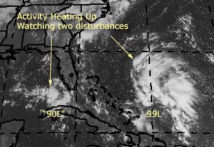
Development Potential scale for System East of Bahamas (aka 99L)
Code:
forget it) 0 1 2 3 4 5 6 7 8 9 10 (sure thing)

          [----------------*-----]
West of Florida Keys (aka 90L)
Code:
forget it) 0 1 2 3 4 5 6 7 8 9 10 (sure thing)

          [---------*------------]
Yes the tropics are now heating up. Both of these systems need to be watched. Since they have not developed into depressions or named storms yet, we'll have to rely on persistence to keep track. They are both are in very interesting positions and both do have the potential to impact land in some way down the road, but this is much too early to call as to what form or strength now. Right now, I don't expect too much from either.
Site Note: Popups now fixed for Safari, Mozilla Firefox, etc browser users. As well and National Weather Service Area Forecast Discussions that may reference either storm of interest now are listed at the top.
General Links
Current Aircraft Recon Info
NRL Monterey Marine Meteorology Division Forecast Track of Active Systems (Good Forecast Track Graphic and Satellite Photos)
Check the Storm Forum from time to time for comments on any new developing system.
Follow worldwide SST evolution here:
Global SST Animation
NASA GHCC Interactive Satellite images at:
North Atlantic Visible (Daytime Only), Infrared, Water Vapor
Some forecast models:
NGM, AVN, MRF, ETA ECMWF
AVN, CMC, GFDL, JMA, NOGAPS, UKMET
DoD Weather Models (NOGAPS, AVN, MRF)
Multi-model plots from WREL
Other commentary at Mike Anderson's East Coast Tropical Weather Center, Independentwx.com, Robert Lightbown/Crown Weather Tropical Update Accuweather's Joe Bastardi (now subcriber only unfortunately), Hurricane Alley North Atlantic Page, Cyclomax (Rich B.), Hurricane City , mpittweather , Gary Gray's Millennium Weather, Barometer Bob's Hurricane Hollow, Snonut,
Even more on the links page.
| James88 |
| (Weather Master) |
| Thu Jul 29 2004 05:07 PM |

|
|
|
99L is probably the best looking system we've had yet this season! It would be extremely surprising (not to mention disappointing) if we didn't get at least a TD out of it.
| Allison |
| (Weather Guru) |
| Thu Jul 29 2004 05:18 PM |

|
|
|
Yikes! And I'm headed to Florida for the weekend!
Allison
(umbrella in tow)
| javlin |
| (Weather Master) |
| Thu Jul 29 2004 05:42 PM |
|
|
The 99L is the more impressive of the two systems.The dry air on the W side seems to be getting choked off some now.The GOM system will take a little longer to develop because some of the shear that 99L is appling to it.The distance between the two is not much maybe 600>800 miles.The 90L needs to move some for development to occur.The GC area is forecast for showers later today because of a regressing front.This front goes up the E coast this should impact the systems to W more so later this evening and tomorrow.All in all the 99L looks good togo for development.It should be an interesting weekend.
| rmbjoe1954 |
| (Weather Master) |
| Thu Jul 29 2004 05:57 PM |

|
|
|
The sat shows 99L heading NW; perhaps it's back on track to the Carolinas.
| Old Sailor |
| (Storm Tracker) |
| Thu Jul 29 2004 06:25 PM |

|
|
|
I think if 90L keep the thunder storms ovenight then going to see a TS in mid of GOM ,if not then just a low or at best TD. 99L not sure about that one just maybe a rain making unless it there is a surface low, wait and see game.....
Dave 3 days shy of 75 yrs...
| LI Phil |
| (User) |
| Thu Jul 29 2004 06:32 PM |

|
|
|
Anybody know why we haven't gotten any Dvorak readings for either 99L or 90L?
| Unregistered User |
| (Unregistered) |
| Thu Jul 29 2004 06:48 PM |
|
|
Just a few observations from Miami. The rain stopped. There are blue skies overhead and a strong breeze out of the East. This is a sudden change, btw.. and not the heavy torrential rains that were promised for today.
On Invest site...IR shows no reds in either system though. Would like to see a little more intensity before deciding this is a sure thing.
Does have that look though.. it is singing to me.
| HanKFranK |
| (User) |
| Thu Jul 29 2004 07:12 PM |

|
|
|
circumstances got me off work today early. more to look at than i'd expected. going to be working the treestands and property at my grandpa's tomorrow so probably won't be around WHEN THE TIME COMES, but i'll try to predict upcoming events now.
the eastpac has spit out system number four (blas, celia, darby, 6E) in the last two weeks, and now the atlantic has finally responded in kind with the upstream development. over in the westpac the pattern drove a typhoon on an unusual northwest track near japan, which teleconnects to a hit on the s.e. coast. the precursors were there, the gate is down.. and today we have two invests.
99L (invest 10) is impressive and probably well suited to develop quickly once a surface low develops. convection is persisting and refiring in the diffluent zone east of the upper trough near the bahamas, and has the potential to support a healthy tropical cyclone. even though 90L (invest 11) has a better surface setup, 99L is rapidly catching up. already the low cloud movements are beginning to hairpin near the convection, and i'm sure that there have been some pressure falls. i believe a tropical depression will form there tomorrow morning and be alex by evening. haven't had a great view of the models, but feel it's overall movement will be slowly nw to the s.e. coast between melbourne and georgetown. it should will probably reach the s.e. coast sunday or monday (should slow down as it nears 80w). a lot can happen between now and then, or nothing can happen, but there is potential for an interesting time.
for 90L, development should be slower. if 99L cranks quickly it will likely be inhibited. initial movement for 90L should be erraticly westward and slow.. if it develops it will likely come north between the big bend and the ms/al line middle of next week.
it is very likely we'll have a named storm by the weekend. it is also likely that a tropical system will landfall in the southeastern u.s. by the middle of next week. if both develop they'll be close enough to affect one another, fujiwhara or otherwise.
we've had a few false alarms early this season.. looks like the real thing this time. get psyched.
HF 1912z29july
| Old Sailor |
| (Storm Tracker) |
| Thu Jul 29 2004 07:24 PM |
|
|
|
|
Dvorak readings for either 99L or 90L From what I can see both too weak for a reading, everybody seems to be jumping on 99L, my gut tells me 90L maybe the one to watch. again it's a wait and see thing.
Dave
| SirCane |
| (Storm Tracker) |
| Thu Jul 29 2004 07:35 PM |

|
|
|
It was only a matter of time before something popped up! I wouldn't be surprised to see a southeast double wammy come next week!
| LI Phil |
| (User) |
| Thu Jul 29 2004 07:44 PM |
|
|
|
|
Looking at the latest IR loop I gotta agree with Bobbi & Old Sailor that neither wave is looking all that great at the minute. As far as 99L, though, the faster it develops, the more chance it gets shredded. We need to be patient (as does the wave) with that one. If it becomes Alex, it probably won't be until (Ed's guess) Saturday. 90L may actually be the better candidate for development at present. Either way, though, somebody's gonna see a boatload of tropical moisture from it.
Lets see what the 5:30 TWO says. So far, they've still got the two planes going in tomorrow.
| Cycloneye |
| (Storm Tracker) |
| Thu Jul 29 2004 07:48 PM |
|
|
TROPICAL DEPRESSION INVEST (AL902004) ON 20040729 1800 UTC
...00 HRS... ...12 HRS... ...24 HRS... ...36 HRS...
040729 1800 040730 0600 040730 1800 040731 0600
LAT LON LAT LON LAT LON LAT LON
BAMD 25.5N 83.4W 24.7N 84.8W 24.2N 86.4W 24.1N 88.0W
BAMM 25.5N 83.4W 25.3N 84.5W 25.1N 85.9W 25.3N 87.3W
A98E 25.5N 83.4W 25.5N 84.3W 25.1N 85.4W 24.2N 86.6W
LBAR 25.5N 83.4W 25.2N 84.4W 25.3N 85.8W 25.9N 87.4W
SHIP 25KTS 30KTS 37KTS 44KTS
DSHP 25KTS 30KTS 37KTS 44KTS
...48 HRS... ...72 HRS... ...96 HRS... ..120 HRS...
040731 1800 040801 1800 040802 1800 040803 1800
LAT LON LAT LON LAT LON LAT LON
BAMD 24.3N 89.8W 24.7N 92.9W 24.4N 95.1W 23.6N 97.8W
BAMM 25.5N 88.7W 26.3N 91.1W 26.5N 92.5W 26.5N 93.8W
A98E 23.7N 87.7W 22.4N 89.1W 21.3N 90.3W 21.0N 91.5W
LBAR 26.7N 88.9W 28.6N 90.7W 30.1N 91.2W 31.4N 91.8W
SHIP 53KTS 65KTS 69KTS 71KTS
DSHP 53KTS 65KTS 69KTS 71KTS
...INITIAL CONDITIONS...
LATCUR = 25.5N LONCUR = 83.4W DIRCUR = 270DEG SPDCUR = 5KT
LATM12 = 25.5N LONM12 = 82.3W DIRM12 = 270DEG SPDM12 = 6KT
LATM24 = 25.5N LONM24 = 80.7W
WNDCUR = 25KT RMAXWD = 20NM WNDM12 = 20KT
CENPRS = 1011MB OUTPRS = 1014MB OUTRAD = 150NM SDEPTH = D
RD34NE = 0NM RD34SE = 0NM RD34SW = 0NM RD34NW = 0NM
Dont take this for granted because until the GOM system develops better those plots wont be good.
| James88 |
| (Weather Master) |
| Thu Jul 29 2004 08:00 PM |
|
|
|
|
Well, Bobbi - it looks as though there are a few specs of red beginning to appear on infrared imagery. Maybe this is the increase in intensity that you spoke about. Now that the Storm Floater is over 99L we can get a much better look at it. 90L is also an interesting system though. Either system could go.
| James88 |
| (Weather Master) |
| Thu Jul 29 2004 08:12 PM |
|
|
|
|
Does anyone have a link to weather buoys in the vicinity of 99L and 90L?
| Unregistered User |
| (Unregistered) |
| Thu Jul 29 2004 08:18 PM |
|
|
Here ya go James.
http://www.ndbc.noaa.gov/Maps/Florida.shtml
And while you're at it take a look at this buouy. A pretty good drop.
http://www.ndbc.noaa.gov/station_page.phtml?station=DRYF1
Whoa and another.
http://www.ndbc.noaa.gov/station_page.phtml?station=42003
| Old Sailor |
| (Storm Tracker) |
| Thu Jul 29 2004 08:23 PM |
|
|
|
|
Here you go James, this should help you.
http://www.srh.noaa.gov/sju/caribm.html,
Dave
| James88 |
| (Weather Master) |
| Thu Jul 29 2004 08:23 PM |
|
|
|
|
Thanks a lot, Caneman!

And thanks Old Sailor!
Have a great birthday this week!
| Unregistered User |
| (Unregistered) |
| Thu Jul 29 2004 08:26 PM |
|
|
They are falling throughout the straits and area to the west of Key West.. note tho that the winds are low as well.
Think some ingredient has not shown its face yet, if you ask me.
| Unregistered User |
| (Unregistered) |
| Thu Jul 29 2004 08:29 PM |
|
|
one. small. is it at the surface tho?
notice most of the convention is not over the "center"
only red i saw in the other invest was over Havana..
| Unregistered User |
| (Unregistered) |
| Thu Jul 29 2004 08:47 PM |
|
|
Does anyone think the system forming east of the Bahamas will move due west???
Will the high/ridge establish itself in time for it to move west, any ideas, here in Florida, concerned!!!
| LI Phil |
| (User) |
| Thu Jul 29 2004 08:55 PM |
|
|
|
|
Will try to be brief and paraphrase. JB's very concerned with 90L. Although there is "no objective guidance" for this scenario, he is worried that we are looking at something that if it gets to 45 mph, it could get to 115 in the same amount of time it took it to go from what it is now to a 45-mph storm. He's not calling for this to happen, just throwing it out there. This is due to the fact that the water there is 2 degrees celsius above normal which could speed development. He stresses there is no need for panic.
He's less gung ho on 99L. His take on this on is that it looks more like an elliptical hybrid that will run out of time to pull in strong winds, but can still be a pain in the neck, and if the Gulf potential wasn't there, would obviously be a bigger story.
Very interesting indeed...
| Unregistered User |
| (Unregistered) |
| Thu Jul 29 2004 08:58 PM |
|
|
Here's a chart of the pressure for the past five days at 42003.
http://www.ndbc.noaa.gov/plot_param.phtml?$station=42003$pres$E
| DroopGB31 |
| (Weather Guru) |
| Thu Jul 29 2004 09:03 PM |
|
|
Thanks for sharing Phil, Im always intrested about what JB has to say. I agree with him too, water temps are around 87 degrees in the eastern gulf last time I checked. I got a question for ya'll though, look at the East Gulf bouy data, Station 42023 has winds due East right now, albeit light winds, but about 150/200 miles south DRYF1 has winds light out of the West. Could this be the start of a LLC? Im gonna check some satellites from this area. Any comments welcomed.
| Jamiewx |
| (Storm Tracker) |
| Thu Jul 29 2004 09:14 PM |

|
|
|
TWO still counting both systems for development, now saying both have the potential to become tropical depressions.
Here it is a little early too
For the North Atlantic...Caribbean Sea and the Gulf of Mexico...
Showers and thunderstorms persist in association with a broad area
of low pressure centered in the southeastern Gulf of Mexico near
the Dry Tortugas. Conditions appear to be favorable for gradual
development...and a tropical depression could form during the next
day or two as the system moves slowly west-northwestward. An Air
Force Reserve unit reconnaissance aircraft is scheduled to
investigate this system tomorrow afternoon...if necessary.
The area of disturbed weather centered a few hundred miles east of
the northwestern Bahamas continues to slowly become better
organized. Upper-level winds are becoming more favorable for
development...and this system also has the potential to become a
tropical depression as it moves generally northwestward during the
next day or two. Another reconnaissance aircraft is scheduled to
investigate this system tomorrow afternoon...if necessary.
Elsewhere...tropical storm formation is not expected through Friday.
| Unregistered User |
| (Unregistered) |
| Thu Jul 29 2004 09:18 PM |
|
|
Im not sure about 90I, but I think 99I could be interesting. It looks like it may turn out to be a subtropical storm, though a tropical storm is possible too.
90I im not sure, but if conditions are favorable, things could happen, because the gulf is at a boil.
Sadly im not going to be in Florida next week

| James88 |
| (Weather Master) |
| Thu Jul 29 2004 09:21 PM |
|
|
|
|
Sounds like tomorrow has the potential to be a busy day in the tropics. Hopefully I won't get up tomorrow to find that the systems have disappeared form the satellite.

| ErinAndOpal95 |
| (Verified CFHC User) |
| Thu Jul 29 2004 09:35 PM |
|
|
99I is starting to take on the classic PinWheel shape.
| teal61 |
| (Weather Hobbyist) |
| Thu Jul 29 2004 09:36 PM |
|
|
Something Phil didn't mention. Bastardi also seems to think that 90L will ultimately be a Texas threat. Of course he's probably wrong nearly as much as he is right this type of situation, but he has hit the nail on the head before and is still one of the first sources I visit each day for info on the tropics.
| LI Phil |
| (User) |
| Thu Jul 29 2004 09:46 PM |
|
|
|
|
Teal61, sorry, that is kind of important...if it gets to tropical storm strength by Saturday night, he is thinking hurricane threat on the Tejas coast Monday & Tuesday, and a strong one at that.
Erin & Opal, welcome aboard.
And it's 99"L" (as in atLantic) not I. (unless that was a small a lower case l not an uppercase I. They look the same
 so we try to capitalize them).
That 5:30 TWO certainly leaves the door open for development of both systems. My bet is on the GOM to definitely get a name, whether it's Bonnie or Alex is the question of the hour.
| James88 |
| (Weather Master) |
| Thu Jul 29 2004 09:49 PM |
|
|
|
|
99L is looking just a little bit ragged at the moment, but that could be temporary. Let's see how it looks tomorrow morning and see what tomorrow's recon will find. I think that as long as 99L and 90L remain in the close proximity that they are in now, the influence of 99L will disrupt development. However, once they separate further, 90L will have a good shot at becoming Alex or Bonnie (depending on what 99L does).
| Unregistered User |
| (Unregistered) |
| Thu Jul 29 2004 09:50 PM |
|
|
What if Bastardi was right and the Gulf has more potential?
Atlantic lollygags around like a spinning wheel and sort of kind of develops.. wouldn't the Atlantic Storm if it did get going want to go more west and follow the stronger Gulf Storm?
I know most of you think it will be the other way around.. Atlantic first.. moves off and Gulf deepens slowly but..
what if?

| javlin |
| (Weather Master) |
| Thu Jul 29 2004 09:57 PM |
|
|
I may be way off here guys but the WV imagine it almost looks like 99L is relocating at 24N 68W.The thing I notice on 90L is there is some circulation in the BOC maybe mid-level?I am not good enough to tell if it helps in the evacuation or hurts.How about some thoughts.
http://www.goes.noaa.gov/browsh3.html
| DroopGB31 |
| (Weather Guru) |
| Thu Jul 29 2004 09:58 PM |
|
|
These invest need to develop so we can get some better model data, I dont believe any of the model solutions right now. If we can get a better defined system maybe the models will begin to agree on a track and not go spaghetti O's on us.
| Unregistered User |
| (Unregistered) |
| Thu Jul 29 2004 10:01 PM |
|
|
If "if" was a spliff, we'd be high
 . Anyway, I don't know about 90L. I think 99L ends up being the quicker developer, but probably ends up not being all that strong. It pumps a bunch of water into the periphery of the building back in Bermuda Ridge. My guess would be from the GA/SC border up to Wilmington, NC. Outside chance of a trap and stall off the coast. Landfall guess is sometime Sunday (but I really have to research before making a real call).
For 90L, I'm just going to wait and see. As mentioned, JB likes a Texas solution and I think that's very plausible. The flow out of the Gulf will be slowly from the East, but it's not going anywhere fast. I'd bet if it's a Texas hit it wouldn't be until next Tuesday at the earliest. If it's at a point further east, subject some time. And if it's a Texas hit, where's it gonna go? That's a big coastline and one where an actual hurricane (if one were to develop) could wreck (sp?) any level of havoc depending on place of landfall.
Interesting days coming up.
Steve
| DroopGB31 |
| (Weather Guru) |
| Thu Jul 29 2004 10:08 PM |
|
|
As of right now, my opinion is 99L doesnt look to great. Looks like there may be a LLC in the far SE portion of that mass of clouds. But the water vapor loop shows dry air is still being entrained into the Westside of the low. Thus all convection is east of the main spin. The dry air seems to be dissipating so maybe by tomorrow it will have a better enviroment to strengthen. I dont have much of an opinion on 90L yet.
| javlin |
| (Weather Master) |
| Thu Jul 29 2004 10:14 PM |
|
|
Your right Droop we need to wait it looks like the dry air is about finished and being choked off though.These systems have a tendency to flair up at night.We will have a better handle on it tomorrrow.
| ErinAndOpal95 |
| (Verified CFHC User) |
| Thu Jul 29 2004 10:15 PM |
|
|
The storm convection around 90L is really starting to heat up.
| h2ocean |
| (Weather Hobbyist) |
| Thu Jul 29 2004 10:33 PM |

|
|
|
Interesting...but we all know how the model runs change!
http://files.hurricanealley.net/storms/AL9904MDL01.html
| Unregistered User |
| (Unregistered) |
| Thu Jul 29 2004 10:37 PM |
|
|
>>> If "if" was a spliff, we'd be high .
I'm not sure I follow you...what is a spliff?
While I'm far from an expert, I do have to agree with that which has been said earlier, in that 99L needs to slow down, wind up, get it's bad self together. Then...take aim at the Carolinas. The faster it spins up, the more shear it's going to encounter. And the closer it stays to 90L, the less it's got going for it.
Now, 90L, that's one has Hurricane written all over it. I don't know whether it has CAT III like JB feels "could" happen. But, I think a CAT I is not at all out of the question.
BUT...before I even hypothize on anything happening, I want to first see a TD. Then, (doing best Mike Myers in SNL, imitating his mother in law-you know 'coffee-tawk' with Linda Richmund [I think that was the characters' name]), we'll tawk. Argh, I'm ver-klempft.
Show me the (TD) money, then the TS Alex.
99L. 90L. Can I get a witness?
| HanKFranK |
| (User) |
| Thu Jul 29 2004 10:39 PM |
|
|
|
|
99L's surface trough is east of the main convective blow up. the vortmax in the northern part is moving away west.. with some convection. i don't think it's the primary. a weaker one to the south is drifting almost underneath the upper trough , with the trades barely pushing it (as the main convective blow up is immediately ese of it). as the convective max propagates westward, i'm expecting a closed center to form early tomorrow in the vicinity of 24/72.
away west 90L is being driven slowly southwestward by the upper level winds ahead of the slowly retrograding upper trough. i'm thinking now that the weak surface low will begin deepening closer to cozumel than key west, and stay further to the south. it should also pump the mid level ridge to the north and keep the first shortwave for this weekend out of the picture.. though later one may be in place to get it in the western gulf. earlier i was thinking the shortwave would wind up getting both systems, but this one seems more affected by weather to its east than weather to its northwest.
so yeah, first impulse with 90L probably wrong. but i'm sticking with the thoughts on 99L.
HF 2239z29july
| LI Phil |
| (User) |
| Thu Jul 29 2004 10:39 PM |
|
|
|
|
Arrgh...that was me. I NEVER forget to login.
| Unregistered User |
| (Unregistered) |
| Thu Jul 29 2004 10:58 PM |
|
|
99L looks like it is taking a jog to the north. Is the environment conducive for such a course? I thought it would run NW at the very least with that trough coming south.
| Kevin |
| (Weather Master) |
| Thu Jul 29 2004 11:01 PM |

|
|
|
I really like the look of the Gomex system this evening. You can really see where there is a circulation...just west of the Dry Tortugas. NHC seems to be on the money with this one. If the convection persists overnight, I'd say we'll see TD 1/TD 2 tomorrow. The weather pattern in the Gulf seems to have less commotion than the pattern that is surrounding 99L. Oh-this one has potential too. The shear in the Gulf will probably remain light for the next couple of days, at least. Combine this with a slow motion, and I think you have the recipe for at least a moderate tropical storm. It has to pass the persistence test first though...
| Unregistered User |
| (Unregistered) |
| Thu Jul 29 2004 11:17 PM |
|
|
Look closely at the latest floater 1 loop. On the far western edge about 25.2 N 73 W is that the center of the low spinning due west??? Just wondering, let me see everyones comments.
| LI Phil |
| (User) |
| Thu Jul 29 2004 11:18 PM |
|
|
|
|
This is the first time all season my local NWS has looked towards the south for possible weather (including 98L earlier this week). Here's my local discussion:
BASICALLY BERMUDA HIGH PRESSURE FOR THE WEEKEND...ALTHOUGH WE WILL PAY CLOSE ATTENTION TO THE POTENTIAL DEVELOPMENT OF A TROPICAL CYCLONE EAST OF THE BAHAMAS...WHICH WOULD BE STEERED NW AROUND THE PERIPHERY OF THE BERMUDA HIGH. IF THIS MATERIALIZES...WE COULD BE IMPACTED LOCALLY AS EARLY AS SATURDAY BY RIP CURRENTS AND BY SUNDAY WITH RAIN...AS ITS' MOISTURE WOULD INTERACT AND STREAM NORTH AROUND THE PERIPHERY OF THE HIGH. STAY TUNED.
Sounds like they're getting serious. Usually, the "potential track" for a possible storm and my local forecast don't even come close to jiving. Things are definitely starting to brew...
"STAY TUNED"
| Rich B |
| (British Meteorologist) |
| Thu Jul 29 2004 11:21 PM |
|
|
Hey guys,
well go out for a few hours and come back to find 2 invests up on two developing systems! both look good to me, with something hinting that 90L could be quite a trouble maker, just a gut instinct. Wouldnt be surprised to see both system classified possibly as early as Friday, but i am guessing it wont happen until the Recon flights have been out. There appears to be some evidence of an LLC associated with 99L, but it is located on the southwestern edge of the deep convection. I think somebody has already mentioned that dry air has been entraining into the western half of the circulation, but it looks like this may get cut off shortly, and allow convection to build in the western semicircle too. 90L has an improving appearance too.
Will be interesting to see how both system lok in the morning, but hopefully tomorrow we will have something to watch, and who knows, perhaps we will enter August with Alex AND Bonnie too
Regards
| rmbjoe1954 |
| (Weather Master) |
| Thu Jul 29 2004 11:24 PM |
|
|
|
|
I can't make out if that is the real circulation that is pushing due west.
But anything is possible.
| ticka1 |
| (Weather Hobbyist) |
| Thu Jul 29 2004 11:32 PM |
|
|
Quote:
Something Phil didn't mention. Bastardi also seems to think that 90L will ultimately be a Texas threat. Of course he's probably wrong nearly as much as he is right this type of situation, but he has hit the nail on the head before and is still one of the first sources I visit each day for info on the tropics.
Teal and Phil - what part of Texas is JB refering too? Just curious.....thanks.
| LoisCane |
| (Veteran Storm Chaser) |
| Thu Jul 29 2004 11:36 PM |

|
|
|
good thoughts..good posts..
if the systems had clearly defineable centers that were as good as these thoughts we would be in business
not believing anything til i see it up close and personal
read you all later, thanks
bobbi
| LI Phil |
| (User) |
| Thu Jul 29 2004 11:36 PM |
|
|
|
|
>>> Teal and Phil - what part of Texas is JB refering too? Just curious.....thanks
The Texas coast, of course
Seriously, this far out, he didn't specify. At this point it might not even develop, much less threaten Texas. However, since he did throw it out there, if he gives any hints, I'll be sure to post.
Cheers,
LI Phil
| Old Sailor |
| (Storm Tracker) |
| Thu Jul 29 2004 11:40 PM |
|
|
|
|
I feel that 90L if the thunder storms holds together tonight will end up in Steve's neck of the woods maybe just west of New Orlean's,j ust following the cloud trail here not models right now, Models don't help till you have TD.
Dave
| Unregistered User |
| (Unregistered) |
| Thu Jul 29 2004 11:54 PM |
|
|
Dave,
I think the thing that will keep it west is the lifting upper system which should supress our atmosphere with an upper high. That's just preliminary because I haven't even begun studying the upper charts. But I'd love a free day fo drinking off next week, so whatever powers you get for turning 75, focus some of 'em my way.
What's interesting with 90L is the deep convection of the diurnal kind that seems to be blowing up. I think the high cloudtops HF was talking about are peripheral only.
Steve
| teal61 |
| (Weather Hobbyist) |
| Thu Jul 29 2004 11:58 PM |
|
|
Check this out...
http://www.srh.noaa.gov/mlb/ldis_index.html
Click Real-time Mesoscale Analyses, this is very informative with 90L. Also shows pressure down to 1008mb.
| LI Phil |
| (User) |
| Fri Jul 30 2004 12:27 AM |
|
|
|
|
Does it bother anyone else that Satellite Services Division (SSD) hasn't even issued a Dvorak rating on either invest? Even if it is "too weak," they still offer that explanation. Seems to me they should have some interest in potential development. Just my $.02
| Cycloneye |
| (Storm Tracker) |
| Fri Jul 30 2004 01:01 AM |
|
|
29/2345 UTC 25.7N 71.9W TOO WEAK 99 -- Atlantic Ocean
Here it is Phil.But 90L still is not there.
| Unregistered User |
| (Unregistered) |
| Fri Jul 30 2004 01:20 AM |
|
|
The system east of the Bahamas is reforming further south and east of the previous 'focus' of convection.
Looks like the Gulf system is beginning to show some banding..
I made a prediction yesterday that we would have a system east of Fl within 72 hours (td or ts) and within 120 hours west of Fl...standing on that.
Hey...take a look at this on the CHC site (not related to current activity but very neat).
http://www.atl.ec.gc.ca/weather/hurricane/climatology/images/frequencymap1.png
sc

| Unregistered User |
| (Unregistered) |
| Fri Jul 30 2004 01:28 AM |
|
|
just passing by and thought this looked interesting:
gfdl run from late afternoon.... still think mid gulf coast in prime target.... looks like the storms are trying to form tonight.... 99L looks to be the first of the season..... i say 99L would be a TS by afternoon tmrow...... 90L needs a little help..... GA,nFL and SC.... need any rain?
http://bricker.met.psu.edu/trop-cgi/gfdl...;hour=Animation
| Rob_M |
| (Weather Hobbyist) |
| Fri Jul 30 2004 01:39 AM |

|
|
|
FWIW, Kevin and I just finished the discussion below. Looks like a busy weekend ahead for us.
Note: Our forecast products are unofficial. Please read our disclaimer.
IWIC Atlantic Tropical Weather Discussion - 29 July 2004 - 9:20 PM EDT
The Atlantic Basin has become a bit more active today. There remains two prominent areas of interest, one being a surface trough just northeast of the Bahamas, and the other a broad surface low pressure just east of the Florida Straits.
The surface trough northeast of the Bahamas has been gradually organizing over the past 12 to 24 hours. Visible satellite imagery hints at a possible weak low level circulation developing near 26ºN, 72ºW, though a few more hours of microwave shortwave satellite imagery will be needed to confirm this. Regardless, given these recent satellite imagery trends, we are confident that a definate low level circulation will develop around the coordinates given above within the next 12 hours. Weak to moderate low level convergence is noted around the possible low, particularly from the south. Convection as a whole associated with the system is on a diurnal wane, though an upper level low to the south is helping to enhance convection southeast of the potential center by creating strong lift. At the same time, it is currently restricting convective development in the southwest quadrant. Meanwhile, an upper level ridge is noted over the northern half of the system, enabling a decent anticyclonic outflow pattern to establish in the northern and eastern quadrants. This overall situation is more baroclinic than barotropic, though changes appear to be in store. Model guidance indicates that the upper level low will continue to slowly slide southwestward. In response, this will allow for the upper level ridge to expand further south so that it encompasses nearly the entire system. This will permit ventilation aloft in all quadrants, a necessity for a true tropical cyclone. The progged southwestward or southward position of the upper level low will aid convection in the center of the disturbance as well. With a large upper level ridge progged to be located directly over the surface center, wind shear should not be a problem. Global models are not too agressive on intensity despite this, however. Most only show development into a tropical depression or tropical storm at the most. Some, such as the GFS, do not show anything more than an inverted trough. The dynamical SHIPS model is more bullish than the global model suite, and strengthens it to a moderate tropical storm in the next 48 hours. Considering the recent organization trend and the already building favorable upper tropospheric pattern, there is good potential for tropical depression or tropical storm development within the next 24 hours. However, taking model guidance into account and the lack of a lot of time spent over water, nothing more is anticipated.
The future track of the system depends solely on the position of the subtropical ridge and the timing arrival of a trough currently located over the central United States plains. Motion over the past 12 to 24 hours has been very slowly towards the west-northwest, which is expected to continue in the near future along the prehiphery of the subtropical ridge. Thereafter, some uncertainty arises. Once the trough approaches the United States east coast, the westward flank of the subtropical ridge will be pushed further east, thus curving the system north or northeastward. When this will happen, and whether it will happen before landfall, is the main question. The majority of the global models take the trough far enough east to influence the system in 60 to 72 hours. Given the current slow motion, this supports a right curve while still over water, thus taking it into eastern North Carolina rather than Georgia or South Carolina. The most recent run of the tropical models suggests otherwise, though little trust should be put into these models as most of them are primarily designed to handle purely tropcial situations south of 20ºN. Based on all of this, landfall in northern South Carolina or North Carolina is expected from the south-southwest late Sunday or early Monday. There remains some uncertainty in the exact time and location of landfall, as well as the intensity of the system. Thus, residents living along the coast from northern Florida to Virginia should monitor the progress of this disturbance. An Air Force Reserve Reconnaissance plane will investigate the area tomorrow if needed.
The second area of interest lies in the Gulf of Mexico. A broad area of low pressure is located just to the west of Dry Tortugas in the Florida Straits. Convection is increasing around its fringes this evening, mostly due to diurnal enhancement. Nonetheless, the organization as a whole is better now than it was 12 to 24 hours ago, with moderate low level convergence and anticyclonic flow aloft. The synoptic environment is gradually becoming more conducive for development. Model guidance still depicts a large upper level ridge building over the Gulf of Mexico in the near future. This will allow for greatly reduced shear values and strong evacuation aloft. Additionally, water temperatures and hurricane heat potential are more than sufficient to support a tropical cyclone in the Gulf of Mexico. If convection persists overnight and the circulation becomes better defined, this system will become a candidate for classification tomorrow. As mentioned above, conditions will allow for at least gradual strengthening over the next few days. It is also important to note that this system could be a slow mover even in the longer term, allowing more time over water. All factors subsisting, the prospect of strengthening looks good with this system. The Dynamical SHIPS model brings the low to a minimal hurricane in 120 hours. Global models are much less aggressive, but nearly all of them still show development. Based on the progged upper level pattern, recent organization trends, and model guidance, intensification to a tropical depression or tropical storm is a decent possibility over the next 36 hours. It is uncertain as to how strong this will become, but any low that stays over the warm Gulf of Mexico waters for several days under a large ridge aloft is always subject to concern.
The system is moving slowly towards the southwest at this time due to a temporary fluctuation in the low-level steering currents in the eastern Gulf of Mexico. Earlier today, east-southeasterly steering currents were observed. The recent fluctuation in steering can be attributed to the flattening of ridging to the north and east of the system. As the trough along the United States east coast moves further west, the western flank of the ridge in the subtropical Atlantic should weaken, allowing steering currents in the Gulf to switch to an easterly or east-southeasterly direction. Model guidance is extremely diverged on the future track. The BAMM and BAMD tropical models take it westward towards the Mexican or Texan coastline, as does the UKMET. On the other hand, a lot of the other global models, such as the ETA, GFS, and CMC curve it northward towards the northern Gulf coast. It is too soon to say with certainty which track the system will take. However, given the expected passage of a trough across the eastern half of the United States in the forecast period, a more southerly turn in the steering flow in the Gulf of Mexico would seem reasonable. Provided the system is more than just a tropical wave or a low with minimum central pressure lower than 1010 millibars, a turn more towards the north is the more likely scenario at this time. Furthermore, the tropical models are not very reliable in this type of situation. As with the western Atlantic disturbance, the environment is not completely barotropic, which is the pattern the tropical models perform best. The most likely target for landfall is from central Louisiana to extreme western Florida Panhandle. A more westward motion cannot be discounted yet, so interests in both the northern and western Gulf coasts should pay attention to this system over the upcoming weekend. An Air Force Reserve Reconnaissance plane will investigate this area tomorrow as well, if necessary.
On another note, the GFS continues to show tropical cyclone development from a tropical wave in the eastern Atlantic within the next 72 hours. However, no other model is in agreement with this solution, and the air ahead still looks a bit seasonably dry. We will continue to monitor this region of the Atlantic basin, but significant development is not expected at this time.
http://independentwx.com/atlanticdiscussion.html
| WXMAN RICHIE |
| (Weather Master) |
| Fri Jul 30 2004 01:53 AM |

|
|
|
THERE REMAINS CONSIDERABLE UNCERTAINTY REGARDING THE POSSIBLE TROPICAL SYSTEM TO AFFECT THE CAROLINA COAST OVER THE WEEKEND. THIS
SYSTEM...CURRENTLY EAST OF THE BAHAMAS...HAS APPEARED BETTER ORGANIZED ON SATELLITE THROUGH THE COURSE OF THE DAY. THE NATIONAL
HURRICANE CENTER INDICATED THAT CONDITIONS ARE FAVORABLE FOR A TROPICAL DEPRESSION TO FORM DURING THE NEXT DAY OR TWO. WE WILL NEED
TO CLOSELY MONITOR THIS SYSTEM...AS THE MODELS HAVE BEEN FAIRLY CONSISTENT IN TRACKING IT TO THE CAROLINA COAST. WHERE THE MODELS HAVE BEEN LEAST CONSISTENT IS WITH THE TIMING AND STRENGTH OF THIS SYSTEM.
| LoisCane |
| (Veteran Storm Chaser) |
| Fri Jul 30 2004 02:17 AM |
|
|
|
|
great wave, beautiful wave nicest one ive seen in ages
something to think on, more inspiring than the other two systems
| Old Sailor |
| (Storm Tracker) |
| Fri Jul 30 2004 03:41 AM |
|
|
|
|
90L not looking to good tonight, it maybe the land mass of Cuba, like I said this afternoon looked good but needs to keep the thunder storms over night to keep it growning, see what happens tomorrow.
Dave
| Kevin |
| (Weather Master) |
| Fri Jul 30 2004 03:44 AM |
|
|
|
|
Look at this satellite image:
GOES Floater IR
Is that a circulation breaking loose towards the west? Or are my eyes playing trick on me?
| HanKFranK |
| (User) |
| Fri Jul 30 2004 04:03 AM |
|
|
|
|
gotta wake up early tomorrow, but hard to resist a late check.
99L: was thinking that the vortmax scraping along under the upper trough was going to be superceded by a secondary further east.. not so. there is some convection just north of the pick of the litter, and as the diurnal/enhanced convection southeast of this embryonic center goes away i expect the trades will get enough surface convergence in the area for it to jump off tomorrow morning. somewhat west of where i was thinking.. thinking i'll keep my forecast track south of what most are saying, more of a ga/fl thing than a sc/nc one. also, as usual, take issue with the folks calling it more baroclinic than barotropic. it's a wave interacting with a trough split.. not a cut off hybrid low. probably a third of all tropical cyclones form this way, aided by convection-enhancing pockets within the nearby upper pattern.
90L: broad and taking it slowly. i'm guessing it will originate close to the western tip of cuba, and meander for a couple days while the upper pattern modifies nearby. a mid-upper vortmax just jetted over it this evening and has helped keep it disorganized.. eventually it will buck that trend.
as for the ultimate track of either system.. 99L is the easier to determine since the atlantic ridge (and a shortwave of dubious strength) will define its path once it gets organized. 90L is less influenced by either and probably going to do some meandering as the steering influences in the gulf are unclear at this point. really, dependent on when and how much either system strengthens, there is a whole realm of possibilites for future track. when the systems are organized enough to be classified, we'll start getting a real feel for specifics.. at this point suffice to say 99L will likely moving towards the upper east florida to south carolina coast, and 90L will probably jig-bob around while the flow around it modifies.. eventually go west to northwest, and hit somewhere along the gulf coast to be determined by how amplified the shortwaves traveling by to the north become.
that was really a lot of rhetoric, like you may have just heard on a political convention. we've got weak systems and they're really hard to nail down.
waves in the east atlantic coming across. they're wait/see for now.
HF 0403z30july
| DroopGB31 |
| (Weather Guru) |
| Fri Jul 30 2004 05:39 AM |
|
|
Well, It seems to get real quiet in here during the evenings, even with 2 invest up. I was just looking at the satellite shot of 90L and it looks to have a definite cyclonic turning thing goin on, and even some banding features. I say give it 18 more hours and a bit of convection and we have our first TD. I would say 12 hours but recon wont be going in till the afternoon I think? As for the track, I'd expect right now, the SW drift to halt after the ridge comes into place over the gulf. From there basically a slow wobbling until something comes along to kick it out, From there Im gonna say N.O to Pensacola. No scientific research behind my "landfall guess", just the fact almost anything in the gulf hits around that area and the fact I go back to school Monday. Maybe something to possibly extend my summer? One can only hope!
 J/K no wishcasting in my front.
| James88 |
| (Weather Master) |
| Fri Jul 30 2004 06:48 AM |
|
|
|
|
An impressive flare up is taking place with 99L this morning, and it definately looks like it is getting better organised. 90L meanwhile continues to be fairly broad with little associated deep convection, but that doesn't mean to say we should write it off yet. I still think it can develop. Let's see what the recon missions find today.
Here's the 5:30 TWO -
FOR THE NORTH ATLANTIC...CARIBBEAN SEA AND THE GULF OF MEXICO...
AN AREA OF DISTURBED WEATHER IS CENTERED A COUPLE OF HUNDRED MILES
EAST OF THE NORTHWESTERN BAHAMAS THIS MORNING AND IT APPEARS TO
SLOWLY BECOMING BETTER ORGANIZED. THIS SYIR FORCE RESERVE UNIT RECONNAISSANCE
AIRCRAFT IS SCHEDULED TO INVESTIGATE THIS SYSTEM LATER TODAY.
A BROAD AREA OF LOW PRESSURCE RESERVE UNIT RECONNAISSANCE
AIRCRAFT IS SCHEDULED TO INVESTIGATE THIS SYSTEM LATER TODAY.
A BROAD AREA OF LOW PRESSURE IS LOCATED IN THE EXTREME SOUTHEASTERN
GULF OF MEXICO THIS MORNING AND THUNDERSTORM ACTIVITY REMAINS
LIMITED AND DISORGANIZED. HOWEVER...CONDITIONS MAY BE FAVORABLE
FOR GRADUAL DEVELOPMENT ...AND A TROPICAL DEPRESSION COULD FORM
DURING THE NEXT DAY OR TWO AS THE SYSTEM MOVES SLOWLY
NORTHWESTWARD. IF NECESSARY...A RECONNAISSANCE AIRCRAFT IS
SCHEDULED TO INVESTIGATE LATER TODAY.
ELSEWHERE...TROPICAL STORM FORMATION IS NOT EXPECTED THROUGH
SATURDAY.
Looks like a couple of typing errors.
99L now has a T number of 1.0 - so it should be packing winds of about 25 kts.
| Unregistered User |
| (Unregistered) |
| Fri Jul 30 2004 11:35 AM |
|
|
Seems like 99L is getting better organized this morning, with what seems to be a llc developing east of the central Bahamas. The wave is moving slowly westward at the moment. If a depression forms, folks from south Florida to the Carolinas need to watch this closely. The circulation from what was the ULL is pulling deep tropical moisture up from the south, and its beginning to show that "S" pattern. WHere this may go IF it forms is still a big question,
| h2ocean |
| (Weather Hobbyist) |
| Fri Jul 30 2004 12:12 PM |
|
|
|
|
99L is looking pretty good this morning on the first Visible shots, 90L - not so sure this morning. It looks like it is being impacted by some shear from the NE which is pushing convection to the SW, but there is rotation. Also, wouldn't be surprised to see a new invest on the wave off of Africa - it look very good this morning and GFS is no longer the only model developing a storm out of this wave.
| LI Phil |
| (User) |
| Fri Jul 30 2004 12:24 PM |
|
|
|
|
Have to be brief. This morning JB is still sticking with yesterday afternoon's thoughts, with some embellishment. Feels 99L will get to TS status and landfall somewhere near the SC/NC border Sunday. He is also bullish on 90L with one caveat. He likens the two disturbances to two bullies on a playground and you can only have one bully on a playground. Therefore, he feels 99L will continue to develop at the expense of 90L for the time being. Once 99L landfalls and loses energy, 90L will start to crank. The caveat is that until such time, 90L is in the dogfight of its life to survive. For this, he uses the analogy of pushing a boulder up a hill. Very difficult to do, but if it does happen, then it will rapidly descend the hill once the apex is reached. In other words, if 90L can make it up the hill, watch out once it gets to the top. He still worries about Texas as the final destination. Several models back up both scenarios but I won't get into that now.
Well, that wasn't very brief, was it? Talk to y'all later.
Morning,
LI Phil
| rmbjoe1954 |
| (Weather Master) |
| Fri Jul 30 2004 12:33 PM |
|
|
|
|
Are there any models that can tell where 99L is headed based on the steering winds and trough location?
| LI Phil |
| (User) |
| Fri Jul 30 2004 12:39 PM |
|
|
|
|
Joe,
I'm not sure what criteria the models use to determine their possible future direction, but I'm sure the two you mention are certainly factored in. Here's some model graphics:
99L-1
and the
recon
99L-High Seas Forecast
| James88 |
| (Weather Master) |
| Fri Jul 30 2004 12:48 PM |
|
|
|
|
The T number is up to 1.5 - our friend is getting organised. Does anyone think that recon will find a TD when they go in today, or is it too soon to guess?
| LoisCane |
| (Veteran Storm Chaser) |
| Fri Jul 30 2004 12:54 PM |
|
|
|
|
brief.. so hang on..
think joe is wrong and hes in good company
think that its not following his or anyone's time plan and the longer that it sits out there.. the more you have to wonder on a more westerly, wnw scenario as eventually the high will build in and shove it west ..not up the coast.
if it had formed on time yesterday..we'd be talking carolinas
it didnt
it might not today
wouldn't count it out
if it has a chance its for a later time plan and that route is further south with every passing day
gulf.. hey wheres the convection?
always wanted to see havana myself..
its there somewhere i think, playing possum
but two bullies are hanging out in their own little pack talking tough but not really DOING anything
wave out by africa is kick ass.. can i say that here or will that get edited, bummer.. if so.. then edit it that bobbi likes the african wave
early but .. has more twist and shout than either of the invests
and... think its a another day of watching and waiting, not sure nhc isnt wishcasting here but... well.. both could affect populated areas so they have to be cautous cautious? oh heck
and.. you are right hank.. this wasnt a brief post.
you want brief?
NOT TODAY.
good melbourne discussion..MON-THU...LATEST GFS SHOWS THE ATLANTIC RIDGE AXIS SHIFTING SOUTH AS A SURFACE TROUGH PUSHES TO THE MID ATLANTIC COAST. THE GULF SYSTEM IS SHOWN MOVING VERY SLOWLY EARLY THEN SHIFTING NORTHEAST TO OFF THE CAROLINAS LATE IN THE PERIOD. NEEDLESS TO SAY...THERE IS MUCH UNCERTAINTY AS TO WHETHER THERE WILL BE A TROPICAL SYSTEM AT ALL...LET ALONE WHERE IT WILL BE AT ANY GIVEN MOMENT IN THE FUTURE. WITH A LARGE SCALE SOUTH FLOW PROGGED...HAVE TO FIGURE ON PLENTY OF MOISTURE ACROSS THE AREA REGARDLESS OF WHAT GOES ON IN A TROPICAL SENSE. THEREFORE WILL PLAN ON SCATTERED POPS THROUGH THE PERIOD.
| rmbjoe1954 |
| (Weather Master) |
| Fri Jul 30 2004 01:19 PM |
|
|
|
|
Excellent discussion. 99L still stationary, isn't it? Does anyone recognize a LLC feature and where may it be?
This system is too messy-awkward, almost like a teen going thru hormonal changes.
| Unregistered User |
| (Unregistered) |
| Fri Jul 30 2004 01:38 PM |
|
|
Can I post a cool picture of Hur. Isabelle on here?
And if so, how?
|
MikeC
|
| (Admin) |
| Fri Jul 30 2004 01:43 PM |
|
|
Quote:
Can I post a cool picture of Hur. Isabelle on here?
And if so, how?
You can, but we you have to be registered user to upload (To keep people from abusing it). You make a post and can attach a file when you preview it.
| Unregistered User |
| (Unregistered) |
| Fri Jul 30 2004 01:47 PM |
|
|
area of deepest convection is furthest from the "center" and would ask why we wouldn't expect this to die out eventually and as the storms to the se move further into the warm (but dusty) tropics.. develop there?
long shot there....but think the whole thing is a long shot
posted this article in "other weather" or some forum like that on this board.. see? following rules.. wondering tho why we don't have a forum for global warming and one for El Nino to keep this true to tropical weather?
http://news.independent.co.uk/uk/environment/story.jsp?story=546138
| Steve |
| (Senior Storm Chaser) |
| Fri Jul 30 2004 02:12 PM |

|
|
|
Should be an interesting weekend. Too bad too because if I've gotten more than 5 hours sleep any night in the last 2 weeks, it might have been once. And now it's time to wake up out of a deep sleep at 3:30 am to run to the CPU spin some loops so as not to miss anything. (I'm sure I don't have to tell any of you).
99L maintains that hybrid look. I'm guessing it's essentially still an upper feature (Cocin) with a broad, elongated surface low. I still like my GA-SC border to Wilmington (just south of the Outer Banks) idea. I don't know if it's even going to go inland, stall, or turn up north through Coastal North Carolina. But I think the track is fair. Some of the models are doing more with it farther down the road. That remains to be seen.
90L is a slow mover. It can't pick up much convection because it's all a couple hundred miles east and northeast. Looked at a scat last night before bed and the circulation was very evident. Dave Schartz was all over that later on one of the late night tropical updates on TWC as well.
Today's another watch day. Will 99L get organized before moving toward the coast? One would think the opportunity is there. 90L shouldn't do much today. Maybe tomorrow or Sunday, when there is a little distance between the two, something can get rolling.
Steve
| Beach |
| (Weather Guru) |
| Fri Jul 30 2004 02:29 PM |
| Attachment |

|
|
|
I'm sure many of you have this one, but for those of you that don't, it's a must!
Tiltle: "When Mother Nature goes Wild"
| James88 |
| (Weather Master) |
| Fri Jul 30 2004 02:43 PM |
|
|
|
|
Cool image.
 If you don't mind me saying so it isn't Hurricane Isabel. It curculated on the interent as Hurricane Isabel but appears to have been intentionally mislabelled. According to Urbanlegends.com it is actually a supercell thunderstorm rotating around the decaying part of Cyclone Graham, which was off the northwest coast of Australia in February 2003. It wasn't until some time afterwards that the photo was identified correctly. Still, thanks for the awesome picture!
Does anyone know when the recon mission is due to be in 99L? Perhaps there will be a STDS today. Who knows?
| Beach |
| (Weather Guru) |
| Fri Jul 30 2004 02:58 PM |
|
|
|
|
It's is Really... What a bummer!
It is and awesome weather picture reguardless.
Thanks for setting me straight.

| Unregistered User |
| (Unregistered) |
| Fri Jul 30 2004 03:09 PM |
|
|
what is going on there?
http://www.ssd.noaa.gov/PS/TROP/DATA/RT/float-vis-loop.html
where is the 11?
| LI Phil |
| (User) |
| Fri Jul 30 2004 03:12 PM |
|
|
|
|
Coupla-three things...been into that urban legends stuff since 9/11 when a boatload of rumors were spreading. James88 is right that it actually took some time before the picture was actually id'ed. It is a cool pic.
Gotta agree with Steve-o on the 99L call. I'm sticking with my earlier call for a TS and landfalling somewhere between the two Carolinas. It's slow to organize, but that will help it to gain strength. And, while I don't get up in the middle of the night to check out loops, first thing in the am is TWC and CFHC on the 'puter.
When I posted earlier this am, JB hadn't put his tropical vid online, so I gotta go check that out. I also haven't checked on recon, but last I heard, they were scheduled to fly out to 99L around 10 am, so if that's still the case, we should have some data soon.
OK, gotta go do some tropical trawling. Check back wit-cho guys later.
LI Phil
| James88 |
| (Weather Master) |
| Fri Jul 30 2004 03:20 PM |
|
|
|
|
MORNING VISIBLE SATELLITE IMAGERY INDICATES THAT A LOW-LEVEL
CIRCULATION IS FORMING IN THE AREA OF DISTURBED WEATHER CENTERED
ABOUT 270 MILES EAST-NORTHEAST OF FREEPORT IN THE BAHAMAS. AN AIR
FORCE RESERVE HURRICANE HUNTER AIRCRAFT WILL INVESTIGATE THE SYSTEM
THIS AFTERNOON TO DETERMINE IF A TROPICAL OR SUBTROPICAL DEPRESSION
HAS FORMED. ADDITIONAL DEVELOPMENT IS POSSIBLE AS THE SYSTEM MOVES
NORTHWESTWARD ABOUT 10 MPH...AND INTERESTS IN THE SOUTHEASTERN AND
MID-ATLANTIC STATES SHOULD MONITOR ITS PROGRESS.
This sounds promising! It appears we may have our first system later today!
BTW, since it says that the recon will determine if a tropical or subtropical depression has formed, does this mean that it is very likely that the system will be classified?
| Unregistered User |
| (Unregistered) |
| Fri Jul 30 2004 03:25 PM |
|
|
The low pressure east/northeast of Freeport in Bahamas looks like its heading due west !http://wwwghcc.msfc.nasa.gov/cgi-bin/post-goes
| Unregistered User |
| (Unregistered) |
| Fri Jul 30 2004 03:32 PM |
|
|
MORNING VISIBLE SATELLITE IMAGERY INDICATES THAT A LOW-LEVEL
CIRCULATION IS FORMING IN THE AREA OF DISTURBED WEATHER CENTERED
ABOUT 270 MILES EAST-NORTHEAST OF FREEPORT IN THE BAHAMAS. AN AIR
FORCE RESERVE HURRICANE HUNTER AIRCRAFT WILL INVESTIGATE THE SYSTEM
THIS AFTERNOON TO DETERMINE IF A TROPICAL OR SUBTROPICAL DEPRESSION
HAS FORMED. ADDITIONAL DEVELOPMENT IS POSSIBLE AS THE SYSTEM MOVES
NORTHWESTWARD ABOUT 10 MPH...AND INTERESTS IN THE SOUTHEASTERN AND
MID-ATLANTIC STATES SHOULD MONITOR ITS PROGRESS.
What I thought.
sc
| joepub1 |
| (Storm Tracker) |
| Fri Jul 30 2004 03:34 PM |
|
|
Having stared at the loop for about 15 minutes, and then reading the 11 TWO, a LLC has formed at about 27N 75W or in that general area. I look for this to become the first TD by tonight. It seems to me to have a WNW/NW move to it, and I still might see a cloud or two, maybe more, here in Jax before it moves almost due north. It won't make it to hurricane strength at any point IMO. I do think it will a weather event worth noting for somebody, rainmaker if it starts to take off this afternoon. And I do think it will start to take off soon.
90L is broad, to say the least. It's going to have to tighten up it's act a bunch to start moving toward TD statis. Day or two more for this one. The CV wave doesn't do much for me yet, but I'm not looking very hard at the moment, with a baby at my backdoor........
| Unregistered User |
| (Unregistered) |
| Fri Jul 30 2004 03:35 PM |
|
|
Yes, but convection has died off somewhat in the areas they identified, and a rival circulation to the SE is apparent...might not quite be there yet.
BTW: 85 degree water at PCB this am and EIGHTY SEVEN DEGREES at St. Marks....gulf system def drifting wnw, twt.
sc
| Unregistered User |
| (Unregistered) |
| Fri Jul 30 2004 03:36 PM |
|
|
http://wwwghcc.msfc.nasa.gov/GOES/goeseastconus.html
| LI Phil |
| (User) |
| Fri Jul 30 2004 03:36 PM |
|
|
|
|
With Dvorak at 1.5/1.5 on 99L (25 knots) and recon headed in, I'll say we have a TD by this afternoon. They cancelled the recon on 90L (no surprise there).
That wave off the coast of Africa is looking mighty impressive ATTM as well, although that's going to get short shrift until we see what happens with the two invests.
Anyone know when the recon data will filter back in?
| Rabbit |
| (Weather Master) |
| Fri Jul 30 2004 03:45 PM |

|
|
|
may have to wait until 5pm.
I'd rather do that and it be classified then get the data early and not have anything.
two questions:
what is meant by "analog" year? I've seen it in the earlier topics alot
second, what is the site where you are all getting the Dvorak numbers from?
| James88 |
| (Weather Master) |
| Fri Jul 30 2004 03:48 PM |
|
|
|
|
Anolog years are years that in the historical record have global oceanic and atmospheric trends which are substantially similar to the season ahead. These years also provide useful clues as to likely trends in activity that the forthcoming hurricane season may bring.
Here is a link to the T numbers:-
T numbers
| LI Phil |
| (User) |
| Fri Jul 30 2004 03:51 PM |
|
|
|
|
Bugsy,
analog (n) similar or comparable in certain respects. An analog year is one where certain or several aspects of the season fit the current one. (ie, was there a strong el nino, when did the first storm form, what were the ssts, etc.). There are no true analogs, as each season will behave differently than others before it, but they may produce similar results.
Here's the link for the Dvorak readings:
http://www.ssd.noaa.gov/PS/TROP/positions.html
Did that answer your questions?
| Unregistered User |
| (Unregistered) |
| Fri Jul 30 2004 03:51 PM |
|
|
if they find it closed off.. west wind
they do use that parameter of bahama systems right?
i mean even a subtropical needs a west wind?
yes or no?
maybe they can see something in their flying machines i don't see on the visible
| Unregistered User |
| (Unregistered) |
| Fri Jul 30 2004 03:53 PM |
|
|
question answered
| Unregistered User |
| (Unregistered) |
| Fri Jul 30 2004 04:00 PM |
|
|
My family is headed to palm beach fl from 8-1 til 8-7, does this storm look like it's heading in that direction.
| Rabbit |
| (Weather Master) |
| Fri Jul 30 2004 04:01 PM |
|
|
|
|
it appears to be moving northwest, so it will likely never reach southern Florida
| joepub1 |
| (Storm Tracker) |
| Fri Jul 30 2004 04:02 PM |
|
|
Thanks guys for the link to the T-numbers. One I didn't have bookmarked yet.
The local NWS here in Jax is very calm, as they should be, Our chance for rain goes up after soon to be TD1 passes east and north of us, light N winds for the next day or so. Water is very warm right now. Might expect a little bit of a last second flare-up as "Alex" passes over the gulf stream just before landfall somewhere in the Carolina's, IMO.
| rmbjoe1954 |
| (Weather Master) |
| Fri Jul 30 2004 04:02 PM |
|
|
|
|
From what I can deduce. it would seem you'd be OK in WPB. If a Florida hit were to occur it would be in the northern part of the state..close to Georgia. Worst case, rain and heavy surf.
| Rabbit |
| (Weather Master) |
| Fri Jul 30 2004 04:08 PM |
|
|
|
|
Namtheun nearing landfall in Japan with 75mph winds; in EP, Darby down to 65 and TD6E dissipated
also looks like 90L is not developing because its energy is being pulled into 99L
| rmbjoe1954 |
| (Weather Master) |
| Fri Jul 30 2004 04:10 PM |
|
|
|
|
I see rotation at 73W28N(or therabouts), is that accurate and would that be the LLC?
| doug |
| (Weather Analyst) |
| Fri Jul 30 2004 04:16 PM |
|
|
Yes that is close, about 28/75 i think.
I trhink the NHC has lost the remants of 90L. Radar suggests the circulation has been surpressed down below Cuba; it seemed to be just north of Cuba this AM. More moisture to work with and more favorable conditions, but this one is slow to develop.
Can any body find 90L?
| joepub1 |
| (Storm Tracker) |
| Fri Jul 30 2004 04:26 PM |
|
|
Doug is real close on the LLC. 90L is not being helped by 99L's drift to WNW (instead of the NW). It needs some distance between the two and it's not getting any at the moment. The more northward 99L gets going the better for 90L. The more westward 99L drifts, then I think somebody on the east coast from N FL up ends up with a small, not much to talk about TS, and 90L has to fight for it's life for the near future.
| doug |
| (Weather Analyst) |
| Fri Jul 30 2004 04:28 PM |
|
|
I studied the loops too. this is a complex system and I see why the NHC is alluding to sub tropical...the surface feature is where we have suggested, BUT ther is stlii an active and well developed upper low behind and to the SE (now) of the surface low. I think the upper low has shown remarkable resiliance and it still is very much influencing this system.
Until this surface low sheds the upper low It may never be purely tropical. As it seems now this system must still be dependent on cool dry air drawn in by the upper low for some of its energy.
Any way that's how it looks to me.
| Unregistered User |
| (Unregistered) |
| Fri Jul 30 2004 04:30 PM |
|
|
can be injurious to your mental health.. i know
and eyes.. my gosh ..fifteen minutes.. beating me here
think there is a second center where i gave cords before that is on some level (low/middle) and shows up on visible.. to the southeast
but could be under chaotic pattern overall further west too
as for wierd theories..
remember how we had that wave that wasn't a td and everyone was all nuts and in love with it? and the energy like warped out of there as if scottie had beamed it north into the atlantic..
well.. not sure that what nature taketh it didn't giveth back.. not sure the "energy" from the old Gulf System didn't transverse Cuba and got spit out south of Cuba
talk about oozy systems
| Unregistered User |
| (Unregistered) |
| Fri Jul 30 2004 04:32 PM |
|
|
90L is still there, it's 150-200 miles wnw of Key West moving off to the WNW slowly. The circulation is quite large and very easy to spot on the visual. It takes up most of the Gulf east of 90W. All it needs is convection and it will be off to the races as the low level circulation is well established.
This is Teal61 by the way, I'm at work and can't log in.
| GaryC |
| (Weather Guru) |
| Fri Jul 30 2004 04:49 PM |
|
|
Can someone tell me how to get the wind speed for what a T # is?
| doug |
| (Weather Analyst) |
| Fri Jul 30 2004 04:50 PM |
|
|
Good call on 90L. Unfortunately the moisture over it is paltry. It has pused far enough out to be away from that NE dry upper flow which was enhanced by the upper low in the Bahama on Wed and Thurs and it may be trying to pull up the moisture SE of it.
Still curious about the gathering of convection and moisture south and over Western Cuba, which seems to have a life of its own?
| LI Phil |
| (User) |
| Fri Jul 30 2004 04:53 PM |
|
|
|
|
Dvorak Chart
| Rabbit |
| (Weather Master) |
| Fri Jul 30 2004 04:54 PM |
|
|
|
|
99L may finally be the first (classified) depression of 2004
the center is there, there is light shear compared to several days ago, and there are numerous thunderstorms around the system
if it is classified, it will likely be in about 24 hours
| Cycloneye |
| (Storm Tracker) |
| Fri Jul 30 2004 05:00 PM |
|
|
URNT11 KNHC 301647
97779 16474 60275 83200 56200 05010 55668 /4588
RMK AF963 01CCA INVEST OB 04
;
But what all those numbers mean is the question as I dont know to read that.Someone who can explain the observations will be very apreciated to explain what they are seeing and recollecting in terms of data.
| joepub1 |
| (Storm Tracker) |
| Fri Jul 30 2004 05:17 PM |
|
|
For lack of a better answer, I'd say that was a test message, going by the location of the plane, 27.5W 83.2 N. It's not there yet.
| Rabbit |
| (Weather Master) |
| Fri Jul 30 2004 05:24 PM |
|
|
|
|
http://bricker.met.psu.edu/trop-cgi/gfdl...&hour=126hr
this is the gfdl model at 126 hours
look to the east of the Antilles
a depression forecast to form?
| James88 |
| (Weather Master) |
| Fri Jul 30 2004 05:29 PM |
|
|
|
|
Seems like there is an increasingly loud call for a CV system in the near future. The season is really starting to warm up!
| joepub1 |
| (Storm Tracker) |
| Fri Jul 30 2004 05:34 PM |
|
|
The AVN tries to put twins out there within a week.....
| Unregistered User |
| (Unregistered) |
| Fri Jul 30 2004 06:03 PM |
|
|
come on... don't tease
tell me more about the twins..
talking boy and girl twins?
| James88 |
| (Weather Master) |
| Fri Jul 30 2004 06:14 PM |
|
|
|
|
Bonnie and Charley?
99L doesn't have that much time left - 12z ETA has the system moving inland in less than two days. However, I've heard that this model is not the most reliable with tropical systems. Is that correct?
| Unregistered User |
| (Unregistered) |
| Fri Jul 30 2004 06:17 PM |
|
|
is there a reason why the NHC hasn't updated the discussion?
| Unregistered User |
| (Unregistered) |
| Fri Jul 30 2004 06:19 PM |
|
|
this HAS to be the most pitiful looking thing we have dealt with all year.. season..
yes.. i see it spinning.. there
and there....
which is it
come on..
what are those planes doing
inquiring minds want to know
and does anyone care?
and someone better send it the game plan because it is a day late and a whole lot of geography off..
http://www.ssd.noaa.gov/PS/TROP/DATA/RT/float-vis-loop.html
telling u .. this is sick.. it will be named a subtropical and we can all call it a day, cause it will be five o clock somewhere
| Unregistered User |
| (Unregistered) |
| Fri Jul 30 2004 06:22 PM |
|
|
they wont classify it today, not enough convection around the center
this may turn out to be unclassified ts#5 when all is said and done
| Unregistered User |
| (Unregistered) |
| Fri Jul 30 2004 06:41 PM |
|
|
its NOT TD5
this season calls for kava kava
| Unregistered User |
| (Unregistered) |
| Fri Jul 30 2004 06:44 PM |
|
|
center at 27.5/71 headed just north of west if not west
and secondary center SE of there.. has more of nw movement but is caught up in the flow of the center to the west
thats my call
clouds wrapping a bit more on visible
| Rabbit |
| (Weather Master) |
| Fri Jul 30 2004 06:54 PM |
|
|
|
|
this will not be a tropical storm anytime soon. If it were really that tropical, there would be major convection blowing off of the center with the easterly shear. I think IF it is upgraded at all (NHC has lost some credibility with me) it will likely be a subtropical system
| James88 |
| (Weather Master) |
| Fri Jul 30 2004 06:59 PM |
|
|
|
|
A subtropical system would seem likely based on the current appearance, but we'll really know the score in a few hours. If this is the case, is there a chance that it could make the transition to a tropical system before it leaves us?
| Unregistered User |
| (Unregistered) |
| Fri Jul 30 2004 07:03 PM |
|
|
NHC has a breakdown of how the recon reports are read, at their site. Take a look.
sc
| rmbjoe1954 |
| (Weather Master) |
| Fri Jul 30 2004 07:04 PM |
|
|
|
|
I see one of the centers (76w/28n) pulling 99L to the West; it may seem Florida may not be out of the woods for rainy weather from 99L.
| Rabbit |
| (Weather Master) |
| Fri Jul 30 2004 07:05 PM |
|
|
|
|
could transition, but any first advisory will likely be subtropical
| Unregistered User |
| (Unregistered) |
| Fri Jul 30 2004 07:10 PM |
|
|
good... glad im not getting dizzy from the loop
| rmbjoe1954 |
| (Weather Master) |
| Fri Jul 30 2004 07:30 PM |
|
|
|
|
It does seem like it is pulling west, but I believe it is going WNW; watch out Jxville; you may be in for a soaker.
I'm beginning to see banding around that circulation- but it doesn't seem to have the spirit to mature into something.
| James88 |
| (Weather Master) |
| Fri Jul 30 2004 07:34 PM |
|
|
|
|
Looks like 90L may be trying to pull itself together. There is a little more convection blossoming over the system now.
| Unregistered User |
| (Unregistered) |
| Fri Jul 30 2004 07:34 PM |
|
|
http://www.weather.com/maps/maptype/satelliteworld/caribbeansatellite_large_animated.html
seriously..seen it slowly developing down there.. also see more color in the gulf near the yucatan but talking tucked away neatly south of cuba.. does seem to twist and no im NOT watching the WV loop.
| Unregistered User |
| (Unregistered) |
| Fri Jul 30 2004 07:40 PM |
|
|
http://www.met.inf.cu/radar.asp
taking a break, go on name something w/o me.. have fun
bobbi
| James88 |
| (Weather Master) |
| Fri Jul 30 2004 07:59 PM |
|
|
|
|
Recon have reported a west wind - does this mean we finally have a system on our hands?!
| rmbjoe1954 |
| (Weather Master) |
| Fri Jul 30 2004 08:01 PM |
|
|
|
|
90L OR 99L?
| James88 |
| (Weather Master) |
| Fri Jul 30 2004 08:03 PM |
|
|
|
|
99L - (they cancelled the recon to 90L this morning).
| rmbjoe1954 |
| (Weather Master) |
| Fri Jul 30 2004 08:07 PM |
|
|
|
|
It sure looks nice on satellite-it is moving due west for now.
| h2ocean |
| (Weather Hobbyist) |
| Fri Jul 30 2004 08:20 PM |
|
|
|
|
Yeah, I have been watching that westward movement...I wonder if the models from last evening's run saying it go into FL was onto something? Interestingly the after NWS discussions don't mention any direct impact at all...MLB even said about lower precip. chances some tomorrow. It will be interesting to see where it goes...TV weather folks still saying NC...not so sure about that now, or maybe after a recurve. Interesting if it does hit FL to GA area, that would backup Bastardi's Teleconnection ideas, though he was also saying a Carolina hit.
| Rob_M |
| (Weather Hobbyist) |
| Fri Jul 30 2004 08:21 PM |
|
|
|
|
Seems to be becoming more linear on satellite imagery...not as impressive as it was earlier today. Also, recon has not found sustained winds stronger than 24KT so far. As of now, not looking too good for a classification next advisory. It may try to pull together before reaching the coast...but I don't see anything more than a TD or STD from this one.
Still think 90L has some potential as it moves slowly further W. A pre-existing low level circulation moving slowly under a large upper level ridge in bath Gulf waters always bears watching.
| h2ocean |
| (Weather Hobbyist) |
| Fri Jul 30 2004 08:53 PM |
|
|
|
|
Bastardi's afternoon update still says NC - he says between Cape Lookout and Cape Fear as a 60 mph storm on He is still concerned about the Gulf system.
| GaryC |
| (Weather Guru) |
| Fri Jul 30 2004 08:59 PM |
|
|
any new news about this system?
| Unregistered User |
| (Unregistered) |
| Fri Jul 30 2004 09:00 PM |
|
|
Station 41010 - CANAVERAL EAST 120NM East of Cape Canaveral:
Wind Direction (WDIR): NE ( 40 deg true )
Wind Speed (WSPD): 17.5 kts
Wind Gust (GST): 19.4 kts
Wave Height (WVHT): 5.6 ft
Dominant Wave Period (DPD): 8 sec
Atmospheric Pressure (PRES): 29.91 in
Air Temperature (ATMP): 82.4 °F
Water Temperature (WTMP): 83.8 °F
Dew Point (DEWP): 73.6 °F
Heat Index (HEAT): 88.3 °F
http://www.ndbc.noaa.gov/station_page.phtml?station=41010
Station 41009 - CANAVERAL 20 NM East of Cape Canaveral, FL,:
http://www.ndbc.noaa.gov/station_page.phtml?station=41009
Wind Direction (WDIR): NE ( 50 deg true )
Wind Speed (WSPD): 9.7 kts
Wind Gust (GST): 11.7 kts
Wave Height (WVHT): 3.6 ft
Dominant Wave Period (DPD): 7 sec
Atmospheric Pressure (PRES): 29.91 in
Air Temperature (ATMP): 83.8 °F
Water Temperature (WTMP): 82.8 °F
Dew Point (DEWP): 72.7 °F
Heat Index (HEAT): 90.0 °F
Certainly is warm enough
| LI Phil |
| (User) |
| Fri Jul 30 2004 09:16 PM |
|
|
|
|
Well, the 5:30 TWO says a mouthful. Now, the question is: will we have TD 1 at 11:30? Probably not, but more likely tomorrow. They're sending in a plane to 90L tomorrow. As these two systems begin to separate from each other, I like the chances of each developing more and more.
| James88 |
| (Weather Master) |
| Fri Jul 30 2004 09:22 PM |
|
|
|
|
Yeah, I agree with you Phil. 90L looks quite a bit better than it did earlier today, so although 99L is developing faster, its counterpart may well be the more significant system. Notice that in the latest TWO they have raised the possibilty of a tropical storm forming tonight, rather than just a tropical depression.
| LoisCane |
| (Veteran Storm Chaser) |
| Fri Jul 30 2004 09:38 PM |
|
|
|
|
I think the reasoning here is that if and when something connects it could happen fast and as the water is that hot..it can intensify fast. It's close to the shore and therefore.. they need to be more cautious and watch it carefully.
Better safe than sorry.
Have a great weekend, ill check in Saturday nite. Maybe will have something exciting then..will see.
Take care of yourselves, don't get blurry eyes from all those loops.
| Steve |
| (Senior Storm Chaser) |
| Fri Jul 30 2004 09:47 PM |
|
|
|
|
A brief check around some of the southern Gulf buoys yields the following:
Station 42003 - 260nm South of Panama City Beach: Winds are due east @ 15.5knts gusting to 23.3. Wave Heights are 2.3'. Water Temperature is 88.5 degrees. Pressure is 29.79 (which represents a 4 basis point drop from yesterday's 29.83 @ 4pm).
Gulf Buoy 42001 which is the Mid Gulf Buoy about 180nm South of SW Pass, LA shows a similar .04 drop in pressure from yesterday. The winds here are due north @ 11.7knts gusting to 15.5knts. Water temps are 86.4.
Gulf Buoy 42041 which is 110nm S of Grand Isle shows a .03 pressure drop and also winds out of the NNE @ 3.9kts.
BURL1 which is located in SW Pass, LA has a .03 drop from yesterday and has ENE (True) winds at 8knts.
----------------------------------------------
Most of the buoys off of the FL coast show rising pressure compared to yesterday and show E, SE or ESE winds. The buoys to the north and west of the circulation are N and NE. Buoys farther toward Texas show no evidence (obviously) at this time of any deepenings in the Gulf.
Developing situation? I report, you decide.
Steve
| Rich B |
| (British Meteorologist) |
| Fri Jul 30 2004 09:48 PM |
|
|
Hey guys,
i noticed the apparent westward motion of the system to in recent satellite imagery. Could this be a possible attempt and the centre trying to relocate or consolidate? Think we should see this become a TD / STD in the next 12 hours, but wouldnt be surprised if NHC held off til tomorrows first light visibles to check for sure.
90L certainly appears to be holding steady and still poses a threat of development, possibly not as immediate as 99L, but certainly soon.
Regards
| LI Phil |
| (User) |
| Fri Jul 30 2004 09:56 PM |
|
|
|
|
Not that it matters, but the board had a record 50 users online at one time today at 4:32 pm. And there have been more than 100 new registered users (though only a few have actually posted) in the recent months. 50 users online is not a lot, but it IS a lot when you consider we haven't even gotten a named storm yet. Imagine how hopping this place will be once we get a CAT III CV hurricane barreling across the Atlantic with eyes on the east coast!
Sticking with my earlier call that we don't get a TD tonight.
| teal61 |
| (Weather Hobbyist) |
| Fri Jul 30 2004 11:15 PM |
|
|
and is about ready to spool up. It will be interesting to see what happens tonight. Looking at the NASA site zoomed in, it looks like the LLC has shifted slightly south nearer the developing convection. Pressures are also lower across the mid GOM as compared to yesterday.
Also, does it look like 99L is moving more west than north to anyone else?

| Unregistered User |
| (Unregistered) |
| Fri Jul 30 2004 11:22 PM |
|
|
I noticed the same movement of 99L. TWC says the Bermuda high is what will cause it to steer northwest.
| h2ocean |
| (Weather Hobbyist) |
| Fri Jul 30 2004 11:25 PM |
|
|
|
|
I just don't see the NW movement...more like just slightly north of due west. Maybe it will shift more north tonight...but if it doesn't, it looks like it would move onshore between the Cape and Jacksonville.
Melbourne Radar
http://www.srh.noaa.gov/radar/loop/DS.p20-r/si.kmlb.shtml
Visible Sat.
http://www.ssd.noaa.gov/PS/TROP/DATA/RT/float-vis-loop.html
| LoisCane |
| (Veteran Storm Chaser) |
| Fri Jul 30 2004 11:26 PM |
|
|
|
|
i dont know WHY suddenly at that lat the bermuda high makes systems go NW..
sorry but at that lat they go west or wnw.. they dont go NW til 30ish and its not at 30..
we have a strong onshore flow out of the east.. not se.. so like..
explain this to me another time
take care, chow
| Cycloneye |
| (Storm Tracker) |
| Fri Jul 30 2004 11:42 PM |
|
|
Depends on the position of the bermuda high if it is more east then the flow will be to the NW like now around the perifery of it and if the high is closer to the US then like Andrew did westward to westnorthwest will be the track.
| Rabbit |
| (Weather Master) |
| Fri Jul 30 2004 11:50 PM |
|
|
|
|
Dvorak numbers are 1.5 on 99L, but looks like the circulation is falling apart in the last couple of hours
90L looks like it is getting better organized, and appears to be developing like Gabrielle in 2001 (looks like pre-Gabrielle low did about 48 hours before becoming a TD)
| Old Sailor |
| (Storm Tracker) |
| Fri Jul 30 2004 11:51 PM |
|
|
|
|
Phil:
I don't think even the NHC is sure where 90L is right now, even their Key West people are not sure if it's due west or southwest of Key West. To many thunderstorms clouds in the area, may be able to local it ,if the storms die down again tonight.
Dave
| LI Phil |
| (User) |
| Sat Jul 31 2004 12:05 AM |
|
|
|
|
>>> second, what is the site where you are all getting the Dvorak numbers from?
Earlier today you didn't even have the site for the Dvorak #'s and didn't know what an "analog" year meant. That's cool, you asked and both James88 & I obliged. Well, you're welcome. Generally when you ask for information and other posters provide it, it's customary to provide an acknowledgement. Now you're an expert on Dvorak?
Smugs, you're welcome to post here anytime, so long as you don't engage in personal attacks, just lighten up on the attitude. You may know the weather pretty well (and you do), but there are others here with 50+ years of experience as actual mets and I've been PMed by them (and others) regarding your tone.
And put some pants on
| Rabbit |
| (Weather Master) |
| Sat Jul 31 2004 12:13 AM |
|
|
|
|
i posted the dvorak numbers with the expectation someone would comment on it and say whether they are up or down, and explain if i am right that the system is becomming disorganized
it is difficult to post very much at the moment--i am on a very old computer with the very flawed windows ME
i was at the college library earlier
if i post too many messages as long as this one, the computer will freeze up
| Rabbit |
| (Weather Master) |
| Sat Jul 31 2004 12:29 AM |
|
|
|
|
i notice that 90L was taken off of the "special features" section
| Cycloneye |
| (Storm Tracker) |
| Sat Jul 31 2004 12:31 AM |
|
|
30/2345 UTC 28.0N 76.1W T1.5/1.5 99 -- Atlantic Ocean
Phil those are the latest T numbers for tonight with respect of 99L so no changes there.
| Rabbit |
| (Weather Master) |
| Sat Jul 31 2004 12:45 AM |
|
|
|
|
so I see it has moved northwest. or at least WNW
the visible image appears to be getting less organized, but the IR appears to show a low level center under a building ridge
are either of these correct or am i just getting tired and beginning to see things that aren't there?
| Tropics Guy |
| (Storm Tracker) |
| Sat Jul 31 2004 12:54 AM |

|
|
|
Really a complex system, just seems to me that the LLC of 99L is westbound towards the Fla Cape, or possibly slightly north of west. Another spin probably a ULL or Mid level circulation seems to be spinning around just east of the bahamas and doesn't appear to be going anywhere fast. 90L may actually develop sooner as some good convection is firing up, and may create a problem for the upper Mexico or Texas coast in a few days.
TG
| Old Sailor |
| (Storm Tracker) |
| Sat Jul 31 2004 01:59 AM |
|
|
|
|
The more I look at both 90L and 99L, get the feeling they both may go the way of the other invest. end up doing nothing, but tomorrow going to be interesting to see..
Dave
| h2ocean |
| (Weather Hobbyist) |
| Sat Jul 31 2004 02:06 AM |
|
|
|
|
Earlier during the last Vis. loop, it looked like the LLC was heading just north of due west towards FL, and it still may be. But on the WV loop, you see there was a bit of a dry slot near a mid to upper level low, which seems to be filling in a little and even a hint of convection building near it. If you look at this part of the system, it is not moving much - maybe a little NW, but if you look at the Dvorak loop, it looks like the main part is moving due west towards Cape Canaveral. Of course this is typical of weak systems where it is not vertically stacked at the low and mid-upper levels. We really won't know until the next Vis. images are available in the morning.
WV Loop
http://www.goes.noaa.gov/HURRLOOPS/huwvloop.html
Dvorak Loop
http://www.ssd.noaa.gov/PS/TROP/DATA/RT/float-bd-loop.html
Also of interest, check out the latest latest GFDL run on 99L, look east of the islands at the end of the loop...it is the wave off of Africa. Nearly all of the models are now developing the wave. The high in the middle of the atlantic should allow for the system to move close to the US.
http://bricker.met.psu.edu/trop-cgi/gfdl...;hour=Animation
| Unregistered User |
| (Unregistered) |
| Sat Jul 31 2004 03:38 AM |
|
|
Hi , reading all your comments with interested for years now ....here is a link to the Cancun radar ...guess you might like it ...specially for the next days ...cheers http://www.passco.com/cancun.htm
Andreas
| Tropics Guy |
| (Storm Tracker) |
| Sat Jul 31 2004 04:00 AM |
|
|
|
|
Thanks for the link to the cancun radar., if 90L can get it's act together, it may come in handy. Currently convection is on the wane, we'll see if any new T-storms blow up around the center tonite. 99L has lost a lot of its convection in the past few hours and is looking kinda ragged., we'll see what the morning brings.
TG
| HanKFranK |
| (User) |
| Sat Jul 31 2004 04:55 AM |
|
|
|
|
this is just like last night... with just minor changes. not what i expected to say the least.
99L is at d1.5, has been there all day. since it's been hanging on the flank of an upper low and in a diffluent/shear environment, there's all this talk about calling it subtropical. nhc is in on the act. i think that's stupid, but too many voices to just blow off.
anyhow, my ideas from yesterday are blown, except for the track. it's about where i was saying, though not classified. only structural difference from last night is that the 'robber convection' (that is, convection that blocks potential inflow and low level convergence from taking place with an embryonic low) is now just east of the center, where it can do some good. less certain, but still think it will be alex tomorrow.
track should turn northward very close to the coast.. none of that n.c. stuff, this is upper florida to lower south carolina all the way. i've been watching the cumulus clouds float by my grandpa's all day from the southeast.. that is the low level driving flow for now.
90L is depressed to the yucatan channel now. probably just about done being jammed sw. ideas on it haven't changed, since it's doing what i want it to. it's interaction with the other system has been that it get's sloppy seconds on inflow and convective support. 99L isn't a permanent fixture however, and this should change over the weekend. probably a classifiable system somewhere north of cancun on sunday. that's if all the stuff that is now firing along cuba doesn't start something first (it is stealing the fire).
possible invest on that new wave. of course it will probably drop everything, but there may be enough left for it to start something. gfs has been harping on it for days, so it's a watcher at least.
that's the story. botched timetables so far, but not totally out to pasture. nite all.
HF 0454z31july
| Steve |
| (Senior Storm Chaser) |
| Sat Jul 31 2004 05:11 AM |
|
|
|
|
Decent quickscat on 90L @ NRL site It's definitely @ 24N, but I can't make out the longitude line from their site. It's a fairly tight and eliptical low with not /that much/ wind. But the cirulcation is there nonetheless. Nothing much to report tonight. SOI is slightly negative (= neutral), SST's are up in the mid gulf (kindlin), and there's a spot between where 90L's at now and the TX/MX coast that allegedly could support < 900mb action. I don't know what's up with 99L. I agree with all that say some type of center is moving toward the FL coast. Some convection is even on the Peninsula. A wave that disengaged itself will be hooking up with 90L sometime tomorrow. Could that be the ignition switch? Or will it just enhance whatever storms fire off tomorrow? We'll see. Nothing is certain, but I like both of my earlier predictions. I'll give it another look tomorrow.
Steve
| James88 |
| (Weather Master) |
| Sat Jul 31 2004 09:39 AM |
|
|
|
|
Well, neither system is any better organised at the moment, but the latest TWO says that there is still potential for development.
Maybe we should cast our eyes east - the wave in the central Atlantic is looking really good this morning. It is moving into warmer waters and is situated in reasonably moist air. I'm not sure what the shear is like out there, but maybe this wave will become a player in a couple of days. As HF said, it could fall apart, but it might not. The UKMET joined the GFS in calling for a system yesterday, so it makes you wonder. What do you guys think?
| Unregistered User |
| (Unregistered) |
| Sat Jul 31 2004 09:55 AM |
|
|
Quote:
Well, neither system is any better organised at the moment, but the latest TWO says that there is still potential for development.
Maybe we should cast our eyes east - the wave in the central Atlantic is looking really good this morning. It is moving into warmer waters and is situated in reasonably moist air. I'm not sure what the shear is like out there, but maybe this wave will become a player in a couple of days. As HF said, it could fall apart, but it might not. The UKMET joined the GFS in calling for a system yesterday, so it makes you wonder. What do you guys think?
Bahamas system runs out of real estate before it can really get going.
Gulf system needs to get W befire it can do anything.
East Atlantic wave now on floater #2. Certainly our first CV system to follow but still seems a little early for anything to develop.
Not what you guys want to hear but as usual August starts prime time.
| Hurricane |
| (Registered User) |
| Sat Jul 31 2004 10:18 AM |
|
|
Floater 2 Image seems to me that it is Darby in the EastPac
cu...
Hurricane
| LadyStorm |
| (Weather Guru) |
| Sat Jul 31 2004 10:55 AM |

|
|
|
Does anyone here know what the flight schedule for 99L is today? :?:
| LadyStorm |
| (Weather Guru) |
| Sat Jul 31 2004 11:25 AM |
|
|
|
|
Did some searching on the net in answer to my question of today's flight plan:
000
NOUS42 KNHC 301600
WEATHER RECONNAISSANCE FLIGHTS
CARCAH, TPC/NATIONAL HURRICANE CENTER, MIAMI,FL.
1200 PM EDT FRI 30 JULY 2004
SUBJECT: TROPICAL CYCLONE PLAN OF THE DAY (TCPOD)
VALID 31/1100Z JUL TO 01/1100Z AUG 2004
TCPOD NUMBER.....04-062
I. ATLANTIC REQUIREMENTS
1. SUSPECT AREA (BAHAMAS)
FLIGHT ONE FLIGHT TWO
A. 31/1200,1800Z A. 01/0000,0600Z
B. AFXXX 02CCA CYCLONE B. AFXXX 03CCA CYCLONE
C. 31/1000Z C. 31/2130Z
D. 29.5.0N 78.0W D. 31.0N 79.0W
E. 31/1100Z TO 31/1830Z E. 31/2300Z TO 01/0630Z
F. SFC TO 10,000 FT F. SFC TO 10,000 FT
2. OUTLOOK FOR SUCCEEDING DAY: CONTINUE 6-HRLY FIXES
IF SYSTEM REMAINS A THREAT.
3. SUSPECT AREA (GULF OF MEXICO)
A. 31/1800Z
B. AFXXX 01DDA INVEST
C. 31/1630Z
D. 26.0N 87.5W
E. 31/1700Z TO 31/2130Z
F. SFC TO 10,000 FT
4. SUCCEEDING DAY OUTLOOK: BEGIN 6-HRLY FIXES AT 01/1200Z
IF SYSTEM DEVELOPS AND IS A THREAT.
5. REMARKS: INVEST SCHEDULED FOR 30/1700Z ON THIS SYSTEM
CANCELLED BY NHC AT 30/1230Z.
II. PACIFIC REQUIREMENTS
1. NEGATIVE RECONNAISSANCE REQUIREMENTS.
2. SUCCEEDING DAY OUTLOOK.....NEGATIVE.
JWP
| Hurric |
| (Weather Guru) |
| Sat Jul 31 2004 11:46 AM |

|
|
|
Quote:
I agree with all that say some type of center is moving toward the FL coast. Some convection is even on the Peninsula. I haven't used the quote button before and Hope that I am quoting Steve correctly. This Link to Melbourne NWS radar clearly shows the circulation around whatever kind ot center has been slowly moving towards the florida coast the past 24 hours. Melbourne Radar
| javlin |
| (Weather Master) |
| Sat Jul 31 2004 11:49 AM |
|
|
If these two systems look later today like they do now there will be no recon.90L getting more shear ans 99L looking ragged.
| Unregistered User |
| (Unregistered) |
| Sat Jul 31 2004 12:00 PM |
|
|
I personally think that 99 looks like it is beginning to finally wrap up.
| LadyStorm |
| (Weather Guru) |
| Sat Jul 31 2004 12:24 PM |
|
|
|
|
I wasn't impressed either, the last time, I checked the radar. I guess we just wait and see.
| Unregistered User |
| (Unregistered) |
| Sat Jul 31 2004 12:31 PM |
|
|
I might be wrong, but it looks to me like it's heading due w or just slightly north of w right for Daytona Beach. The first few visuals are in, after we get a few more we will have a better idea.
| Unregistered User |
| (Unregistered) |
| Sat Jul 31 2004 12:32 PM |
|
|
To the contrary. It finally looks like it is independent of the ULL and is starting to wrap. I believe we'll see a TD today.
| Hurric |
| (Weather Guru) |
| Sat Jul 31 2004 12:56 PM |
|
|
|
|
Just not a lot happening fast with 99L. It looks like a big disorganized blob to me except for the swirl off the central Florida coast. This area int that far from land and unless something changes today the drift towards the WNW will bring it near the coast.
It looks like the possibility of a center forming or reforming further to the East or SE does exist and I am thinking this would be the best bet for further strengthening.
The skies are dark this morning and just a few drops of moisture being squeezed out here in Port St. Lucie. Humm, I guess if this system can attain at least TD status then a claim of rains from a tropical system will be claimed on east central Florida coast. Something inspirational about potential development in this part of the world that encourages me to want to post. The season is near. I can finally feel it. Keep the great posts coming.
Melbourne NWS discussion is interesting and as always a great read. Mel Discus
| Tropics Guy |
| (Storm Tracker) |
| Sat Jul 31 2004 12:59 PM |
|
|
|
|
Not to drop the ball on 99L which looks better this morning, but the east atlantic wave sw of the CV islands is still holding together., I believe that this is the wave that some of the models develop. SST's, shear & environment around it look rather favorable., may see an invest on it later today or tomorow "IF" it holds together.
http://www.ssd.noaa.gov/PS/TROP/DATA/RT/eatl-ir4-loop.html
TG
| Rabbit |
| (Weather Master) |
| Sat Jul 31 2004 01:32 PM |
|
|
|
|
vis loop
wv loop
99L appears not to be falling apart but is actually getting better organized
note the strong low cloud rotation around the system, the large amount of convection over the center, and note the small upper level ridging right over the thunderstorms
plus, its drifting over the gulf stream now
that looks pretty favorable to me
| Unregistered User |
| (Unregistered) |
| Sat Jul 31 2004 03:39 PM |
|
|
I've got two rotation centers plotted:
1) 32N/62W
2) Not exactly sure where the center of circulation for 99L is. It appears it could be north of the blowup of convection around 31/75. But if it's under the convection, it's only around 29 North.