MikeC
|
| (Admin) |
| Sat Jul 31 2004 11:54 PM |
|
|
2:30 PM Aug 1 Update: TD 1 Becomes Tropical Storm Alex
We now have our first named system of this season. At 2PM, NHC upgraded TD1 to TS Alex - located about 80 miles SSE of Charleston, South Carolina. Alex is a minimal TS with sustained winds of 35 knots, and it is currently stationary. The NHC still expects Alex to eventually move to the north and northeast so Tropical Storm Warnings remain in effect for the coastal areas of the Carolinas.
Personally, I would have placed the center a lot further to the south based on the main feeder band, but since the storm has about a half dozen areas of low-level circulation, I guess that for the moment, any one of them will do. Coastal residents of Georgia should also keep a close eye on Alex.
ED
10:45 AM Aug 1 Update:
Tropical Storm Warnings are now up from Cape Fear to Cape Hatteral in North Carolina.
10:30 AM Aug 1 Update:
Tropical Depression 1 is looking better this morning, with Dvorak T#s at 2.0. There is a good chance it'll become Tropical Storm Alex today, but due to its proximity to land the likelyhood of it strengthening much more is slip.
However, I do suspect it will be in strengthening mode when it does make landfall. It's center seems to be reforming now, or adjustin itself.
More to come later.
Original Update
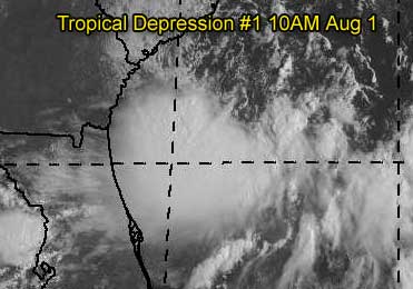
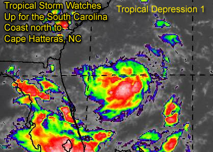
Tropical Depression One has formed east of the Florida Peninsula, and is still rather disorganized. It's track takes it northward towards the Carolinas, and because of this, Tropical Storm Watches are out for South Carolina all the way up to Cape Hatteras in North Carolina.
Folks in the area should be aware of it.
The system in the Gulf (90L) is looking very ragged now, and may not form into a depression. But another storm west of the Cape Verde Islands in the far eastern Atlantic may form over the next few days and become our first "cape verde" tracker of the season. We'll keep an eye out on everything.
More updates to come on TD#1...
Event Related Links
Charleston, SC Long Range Radar
Jacksonville, FL Long Range Radar
General Links
Current Aircraft Recon Info
NRL Monterey Marine Meteorology Division Forecast Track of Active Systems (Good Forecast Track Graphic and Satellite Photos)
Check the Storm Forum from time to time for comments on any new developing system.
Follow worldwide SST evolution here:
Global SST Animation
NASA GHCC Interactive Satellite images at:
North Atlantic Visible (Daytime Only), Infrared, Water Vapor
Some forecast models:
NGM, AVN, MRF, ETA ECMWF
AVN, CMC, GFDL, JMA, NOGAPS, UKMET
DoD Weather Models (NOGAPS, AVN, MRF)
Multi-model plots from WREL
Other commentary at Mike Anderson's East Coast Tropical Weather Center, Independentwx.com, Robert Lightbown/Crown Weather Tropical Update Accuweather's Joe Bastardi (now subcriber only unfortunately), Hurricane Alley North Atlantic Page, Cyclomax (Rich B.), Hurricane City , mpittweather , Gary Gray's Millennium Weather, Barometer Bob's Hurricane Hollow, Snonut,
Even more on the links page.
| LI Phil |
| (User) |
| Sat Jul 31 2004 11:58 PM |

|
|
|
Thanks for the new thread Mike. Looks like TD1 won't be Alex until August, although I do believe this will become Alex sometime tomorrow. Ed's 7/31 guess was pretty good. Old Sailor may get our first named storm on his 75th birthday.
| hurricane_run |
| (Storm Tracker) |
| Sat Jul 31 2004 11:58 PM |

|
|
|
000
WTNT31 KNHC 312340
TCPAT1
BULLETIN
TROPICAL DEPRESSION ONE INTERMEDIATE ADVISORY NUMBER 1A
NWS TPC/NATIONAL HURRICANE CENTER MIAMI FL
8 PM EDT SAT JUL 31 2004
...TROPICAL DEPRESSION REMAINS POORLY ORGANIZED...
A TROPICAL STORM WATCH REMAINS IN EFFECT FROM EDISTO BEACH SOUTH
CAROLINA TO CAPE HATTERAS NORTH CAROLINA...INCLUDING THE PAMLICO
SOUND. A TROPICAL STORM WATCH MEANS THAT TROPICAL STORM CONDITIONS
ARE POSSIBLE IN THE WATCH AREA DURING THE NEXT 36 HOURS.
AT 8 PM EDT...0000Z...THE POORLY DEFINED CENTER OF TROPICAL
DEPRESSION ONE WAS ESTIMATED NEAR LATITUDE 30.9 NORTH...LONGITUDE
78.6 WEST OR ABOUT 145 MILES SOUTH-SOUTHEAST OF CHARLESTON SOUTH
CAROLINA.
THE DEPRESSION HAS BEEN MEANDERING DURING THE PAST COUPLE OF HOURS
BUT IT SHOULD BEGIN TO MOVE TOWARD THE NORTHWEST NEAR 9 MPH LATER
TONIGHT. A GRADUAL TURN TOWARD THE NORTH IS EXPECTED DURING THE
NEXT 24 HOURS. THIS MOTION COULD BRING THE CENTER OF THE TROPICAL
CYCLONE NEAR THE COAST OF THE SOUTHEASTERN UNITED STATES ON SUNDAY.
PRELIMINARY REPORTS FROM THE RECONNAISSANCE AIRCRAFT INDICATE THAT
THE DEPRESSION IS POORLY ORGANIZED. MAXIMUM SUSTAINED WINDS REMAIN
NEAR 30 MPH...WITH HIGHER GUSTS...MAINLY IN SQUALLS TO THE SOUTH
AND EAST OF THE CENTER. SOME SLOW STRENGTHENING IS FORECAST DURING
THE NEXT 24 HOURS...AND THE DEPRESSION COULD BECOME A TROPICAL
STORM ON SUNDAY.
ESTIMATED MINIMUM CENTRAL PRESSURE IS 1010 MB...29.83 INCHES.
REPEATING THE 8 PM EDT POSITION...30.9 N...78.6 W. MOVEMENT
NEARLY STATIONARY. MAXIMUM SUSTAINED WINDS... 30 MPH. MINIMUM
CENTRAL PRESSURE...1010 MB.
FOR STORM INFORMATION SPECIFIC TO YOUR AREA...PLEASE MONITOR
PRODUCTS ISSUED BY YOUR LOCAL WEATHER OFFICE.
THE NEXT ADVISORY WILL BE ISSUED BY THE NATIONAL HURRICANE CENTER AT
11 PM EDT.
FORECASTER AVILA
| hurricane_run |
| (Storm Tracker) |
| Sun Aug 01 2004 12:00 AM |
|
|
|
|
strengths the same but it hasnt moved much. it will have more time to strengthen
| Unregistered User |
| (Unregistered) |
| Sun Aug 01 2004 12:27 AM |
|
|
Well, I have done better this time...back on Wed I predicted (and posted it here on Thurs) that within 72 hours we would have a depression east of fl....now for the hard part....also predicted one in the Gulf in 120 hrs....@48 hours to go....
sc

| LI Phil |
| (User) |
| Sun Aug 01 2004 12:30 AM |
|
|
|
|
I can't seem to find any data from the second recon flight this afternoon. Anyone know what they found?
| Rich B |
| (British Meteorologist) |
| Sun Aug 01 2004 12:43 AM |
|
|
Hey guys,
apologies for the late post but been at work all day and then out this evening celebrating my birthday (25 today!). And looks like i got a decent present too, the first classified system of the 2004 season. Like most of you i dont expect we'll see our first named system til August, but at least we finally have some 'proper' activity. Plenty to watch too as in the previous news item. The wave west of the CV islands actually has been asessed by SSD but no assigned TNumbers as its 'TOO WEAK'. Certainly something else to watch though.
As for TD One. Well i dont expect it to be anything spectacular really. Possibly intensifying to a weak Tropical Storm on Sunday. Landfall, if it happens and the system doesnt recurve out to sea, will probably be as a minimal Tropical Storm with sustained winds of around 45 mph. However, the fact it hasnt moved alot recently suggests it is in the formative stages, and may actually strengthen a little more if it remains over water a little longer.
Anyway, will post more thoughts in the morning.
Kind regards
| LI Phil |
| (User) |
| Sun Aug 01 2004 12:49 AM |
|
|
|
|
Happy 25th guy. You really should post your birthday on your home page, then it'd get on the calendar!
You today, Old Sailor tomorrow. Looks like you both get some b-day presents. Thanks for the hEDs up on the CV wave. Will have to keep atop that one.
Well, I'll let you enjoy your special day. Hopefully your dinner wasn't bangers and mash, enjoy a nice warm bitters for me.
Cheer-e-o,
LI Phil
| Storm Cooper |
| (User) |
| Sun Aug 01 2004 12:55 AM |
|
|
Happy Bday to all! Glad to see some sort of season begin! I still have hope for the little GOM low if it can hang around a day or so. This Buds for you LIPhil!
|
danielw
|
| (Moderator) |
| Sun Aug 01 2004 12:58 AM |

|
|
|
This is the highest wind speed they've tranmitted so far. This was at 8:19EDT. They are still looking. I seem to recall seeing that they were taked until 10 or 11pm EDT tonite.URNT11 KNHC 010019
97779 00194 10300 77600 02900 22026 2322/ /0012
RMK AF963 0301A CYCLONE OB 10
That's 220 degrees at 26 knots. It looks like thats a low level observation.
| Jamiewx |
| (Storm Tracker) |
| Sun Aug 01 2004 01:00 AM |

|
|
|
Well done Ed on coming the closest with the predictions, it may not be the first tropical storm yet, but it is the first tropical cyclone and thats close enough for me. Guess after you have been doing this stuff as long as Ed has you get closer and closer everytime.

| LI Phil |
| (User) |
| Sun Aug 01 2004 01:11 AM |
|
|
|
|
DanW,
Thanks. So they're still zig-zagging through the blob?
| Cycloneye |
| (Storm Tracker) |
| Sun Aug 01 2004 01:42 AM |
|
|
31/2345 UTC 11.1N 33.8W T1.0/1.0 90 -- Atlantic Ocean
Interesting the classification and It looks better than TD #1.
|
danielw
|
| (Moderator) |
| Sun Aug 01 2004 01:43 AM |
|
|
|
|
LI Phil,
Yes, at least they shouldn't have to worry about any turbulence.
Old 90 still managing to fire up some high tops even this late in the day. Appears to be a " ring of fire" centered near 23.0N and 90.0W. IR tops oscillating from the NE quad to the NW quad, last hour. Buoys still don't look that impressive. If it maintains a W-ward drift the Bay of Campeche should bump it up a notch, if at all. You"d think the cool front will pick it up and run it through FL. We'll just have to keep an eye-no pun on it.
| Rabbit |
| (Weather Master) |
| Sun Aug 01 2004 02:22 AM |

|
|
|
east atlantic wave
It is entirely possible that the wave at about 32W could be a TD within 24 to 48 hours, and maybe even a storm after that
Every time I saw the satellite image for it today, it has become better organized each time
This may very well be the system all the models have been hinting at for the last week.
This is starting to remind me of 1999 in mid August. NOTHING from early July to August, then sever storms in a row pop up:
Bret Aug 18, Cindy Aug 18, Dennis Aug 23, Emily Aug 24
wave off of Africa doesnt look all that organized, but could also develop as it moves off
As for TD1, I agree with everyone else that it will not become a TS until tomorrow, if at all, and will not strengthen beyond the NHC forecast.
| Rabbit |
| (Weather Master) |
| Sun Aug 01 2004 02:26 AM |
|
|
|
|
of the TD and the wave
http://www.goes.noaa.gov/HURRLOOPS/huirloop.html
|
danielw
|
| (Moderator) |
| Sun Aug 01 2004 02:35 AM |
|
|
|
|
I think they might better bump up the Dvorak on the wave. It's moving at a fairly good speed. At that speed it might shear itself to pieces.
| hurricane_run |
| (Storm Tracker) |
| Sun Aug 01 2004 02:39 AM |
|
|
|
|
000
WTNT31 KNHC 010228
TCPAT1
BULLETIN
TROPICAL DEPRESSION ONE ADVISORY NUMBER 2
NWS TPC/NATIONAL HURRICANE CENTER MIAMI FL
11 PM EDT SAT JUL 31 2004
...TROPICAL DEPRESSION REMAINS DISORGANIZED...
A TROPICAL STORM WATCH REMAINS IN EFFECT FROM EDISTO BEACH SOUTH
CAROLINA TO CAPE HATTERAS NORTH CAROLINA...INCLUDING THE PAMLICO
SOUND. A TROPICAL STORM WATCH MEANS THAT TROPICAL STORM CONDITIONS
ARE POSSIBLE IN THE WATCH AREA DURING THE NEXT 36 HOURS.
AT 11 PM EDT...0300Z...THE CENTER OF TROPICAL DEPRESSION ONE WAS
LOCATED NEAR LATITUDE 31.4 NORTH...LONGITUDE 78.9 WEST OR ABOUT
115 MILES... 185 KM...SOUTHEAST OF CHARLESTON SOUTH CAROLINA.
THE DEPRESSION IS MOVING TOWARD THE NORTH-NORTHWEST NEAR 8 MPH
...13 KM/HR...AND THIS MOTION IS EXPECTED TO CONTINUE DURING THE
NEXT 24 HOURS. THIS MOTION COULD BRING THE CENTER OF THE TROPICAL
CYCLONE NEAR THE COAST OF THE SOUTHEASTERN UNITED STATES ON SUNDAY.
DATA FROM THE RECONNAISSANCE PLANE INDICATE THAT THE DEPRESSION
REMAINS DISORGANIZED. MAXIMUM SUSTAINED WINDS ARE NEAR 30 MPH...45
KM/HR...WITH HIGHER GUSTS IN A FEW SQUALLS TO THE EAST AND SOUTH OF
THE CENTER. LITTLE CHANGE IN STRENGTH IS FORECAST DURING THE NEXT
24 HOURS.
ESTIMATED MINIMUM CENTRAL PRESSURE IS 1009 MB...29.80 INCHES.
REPEATING THE 11 PM EDT POSITION...31.4 N... 78.9 W. MOVEMENT
TOWARD...NORTH-NORTHWEST NEAR 8 MPH. MAXIMUM SUSTAINED
WINDS... 30 MPH. MINIMUM CENTRAL PRESSURE...1009 MB.
FOR STORM INFORMATION SPECIFIC TO YOUR AREA...PLEASE MONITOR
PRODUCTS ISSUED BY YOUR LOCAL WEATHER OFFICE.
AN INTERMEDIATE ADVISORY WILL BE ISSUED BY THE NATIONAL HURRICANE
CENTER AT 2 AM EDT FOLLOWED BY THE NEXT COMPLETE ADVISORY AT 5 AM
EDT.
FORECASTER AVILA
| hurricane_run |
| (Storm Tracker) |
| Sun Aug 01 2004 02:42 AM |
|
|
|
|
it started to move again. and the pressure has dropped only
1 mb "LITTLE CHANGE IN STRENGTH IS FORECAST DURING THE NEXT 24 HOURS. "
| Old Sailor |
| (Storm Tracker) |
| Sun Aug 01 2004 02:45 AM |

|
|
|
TD 1 , may just stay as a TD a rain maker to the southeast coast, 90L also doesn't appear to be getting it's act together, keeps drifting to the west, more like a wagon train, but you never know with any low in the GOM , not betting on this one to do anything.
Dave
| LI Phil |
| (User) |
| Sun Aug 01 2004 02:51 AM |
|
|
|
|
Hey birthday boy,
Two things: you're really negative on most development, but your're mostly right. Something's wrong there.
Give one of these systems a shot, would ya, so that we have something to track...
Laughing out loud (LOL), but everytime you put the "ky-bosh" on a system, it goes into the tank. STOP THAT!
We want a TD, anywhere, any time.
Enjoy #75 (remember, my pappy is 76).
Cheers,
LI Phil
| Rabbit |
| (Weather Master) |
| Sun Aug 01 2004 02:52 AM |
|
|
|
|
10:30 TWO
A TROPICAL WAVE CENTERED ABOUT 650 MILES WEST-SOUTHWEST OF THE CAPE
VERDE ISLANDS IS MOVING WESTWARD AT 20 TO 25 MPH. SHOWER ACTIVITY
CONTINUES TO SHOW SIGNS OF ORGANIZATION AND ADDITIONAL SLOW
DEVELOPMENT IS POSSIBLE OVER THE NEXT DAY OR SO.
could this be Alex before the TD?
a little note: since the TD has not become Alex at 11 and this is the last advisory of any kind for the month, my forecast will stay the same (I was kind of hoping I would have to update it)
Looks to be a year like 2000.
One of these systems (TD1 or the Atlantic wave) may become Alex. 2000 had Alberto in the first week of August, and I am forecasting a similar year in numbers.
| Old Sailor |
| (Storm Tracker) |
| Sun Aug 01 2004 02:56 AM |
|
|
|
|
Thanks again Phil,
Promise to tell you guys first ,when I get in my car to leave my beach front home a run like H---, been wrong just as many times as right, but my gut feel says no to this one.
Dave
| hurricane_run |
| (Storm Tracker) |
| Sun Aug 01 2004 02:58 AM |
|
|
|
|
at 11pm TD#1 is remaining a tropical depression. but the season looks like its about to crank up. it could still be busy like rabbit said. and in 2000 it was 14/8/2 and alberto came aug. 4. No named storms in july lets see what aug. can bring
| Unregistered User |
| (Unregistered) |
| Sun Aug 01 2004 03:00 AM |
|
|
90L HAS A LOT MORE STORMS OVER THE CENTER .THE PAST 6 HOURS IT IS LOOKING BETTER AND BETTER.IT MAY BE ON ITS WAY.
|
danielw
|
| (Moderator) |
| Sun Aug 01 2004 03:02 AM |
|
|
|
|
Re: the July contest. Did it end at 0000z tonight, or at Midnight EDT?
| LI Phil |
| (User) |
| Sun Aug 01 2004 03:06 AM |
|
|
|
|
At this point, I believe it's rather moot.
|
danielw
|
| (Moderator) |
| Sun Aug 01 2004 03:10 AM |
|
|
|
|
Sorry, I just had to ask.
| LI Phil |
| (User) |
| Sun Aug 01 2004 03:14 AM |
|
|
|
|
Didn't mean to offend...au contraire. Thanks for the answers on the flying tigers (recon). I think the "first storm" still hasn't really been answered...until we get a name, it's still up for grabs. We're (of course I'm speaking for the whole board here) so Jonesing for even a TD, that we'll take anything at this moment (ATTM).
We are about to TAKE OFF, though. This month will make up for June & July.
|
danielw
|
| (Moderator) |
| Sun Aug 01 2004 03:27 AM |
|
|
|
|
Here's the Mid Gulf buoy
01/03z 42001 25.8 -89.7 t29.4 dp25.3 w110@ 16 G 17 pk gst100 19kt 1012.0 pres tend/3h +3.2mb sea temp30.3 wvht1.0mtrs 6sec wv pd 42001
The East Canaveral buoy:
01/03z 41010 28.9 -78.5 t26.2 dp24.1 w210@ 27 G 37 1014.9 pres tend/3h +1.4 sea temp28.8 wv ht2.0mtrs 8sec wv pd 41010
| teal61 |
| (Weather Hobbyist) |
| Sun Aug 01 2004 03:29 AM |
|
|
but the latest quickscat of TD 1
http://manati.wwb.noaa.gov/dataimages21/cur/zooms/WMBas19.png
seems to indicate that the better defined center is well south of the latest NHC position.
Looking at the Dvorak IR loop
http://www.ssd.noaa.gov/PS/TROP/DATA/RT/float-bd-loop.html
You can pick out a weak center up around 32n, but there also appears to be one under the stronger convection down around 27 or 28n and this would agree with what quickscat shows.
Also 90L seems to be hanging in there tonight around 24/90, will be interesting to see if this trend continues through the night and tommorow. Quickscat missed 90L but an earlier one still showed a pretty well defined circulation north of the Yucatan.
|
danielw
|
| (Moderator) |
| Sun Aug 01 2004 03:49 AM |
|
|
|
|
Nice picture. I guess it depends on where you live.
http://hadar.cira.colostate.edu/ramsdis/online/data/tropical/18.jpg
|
MikeC
|
| (Admin) |
| Sun Aug 01 2004 04:17 AM |
|
|
Testing out a new site feature here:
http://flhurricane.com/cyclone/stormhistory.php?storm=1
This link is for the plaintext "csv" version (useful for loading into Excel, databases, etc)
http://flhurricane.com/cyclone/stormhistory.php?storm=1&p=1
A better (More complete) storm position history. Hopefully it'll last the evening without breaking. It's all automated and a bit more complex than what I had made before.
| LoisCane |
| (Veteran Storm Chaser) |
| Sun Aug 01 2004 04:39 AM |

|
|
|
HI.. was away most the day until late this evening and reading through so many posts on the TD.
quickly.. good reading.. nice to read the posts.
think nhc did a good job with it.. it is a TD, sorry it not more exciting for some of you, its just a TD still.. look far to the east for real excitement. I heard the wxr radio around 5 announce the storm.. smiled and smiled even more excited when it mentioned the African wave.. to me that was bigger almost.. having them mention a wave so far away.
Just a note that TD's and weak Tropical Storms can cause a great amount of trouble and flooding ... especially in areas that are already busting with water.
Aren't parts of SC already way over the limit with water?
Thanks for the water loops.
As for the contest .. I've always disagreed with the way its done. To me the first advisory is the start of the season. Not an official name but I'm not in the majority I think here. So, in my mind ed wins though he would probably say "no he meant a storm"
I remember years back SNONUT made some prediction on I think first hurricane.. was more a joking bet online between him and someone else and there was a Tropical Storm .. not a hurricane, strong one on the date and I was so annoyed he qualified it with Hurricane.. so him.. sort of all or nothing person that he is .. but in my mind he really did win but well.. winning is in the eye of the beholder. Won't go political here but that is a subject for debate that will go on past 2004 hurricane season contests on FLhurricane.. for me..think Ed came real close.
So.. we are still looking for that elusive named storm.
I guess to some of you the TD is like an anonymous post.
Happy Birthday Old Sailor.. very happy and who ever is 25.. I'm lost, eyes are blurry from reading.
congratulations to all and to all a good night!
Bobbi
ps..okay i let out a holler when later in the night the NHC said the wave was developing...or whatever they said exactly

|
danielw
|
| (Moderator) |
| Sun Aug 01 2004 05:02 AM |
|
|
|
|
http://weather.msfc.nasa.gov/GOES/goeseastconuswv.html
This WV loop shows a circulation, free of clouds. I can't tell if it's on the surface (probable) or elevated. The thunderstorm complex SW of the circulation has expanded over the last 3-4 hours. Now nearing 95W. Don't see an awful lot of lightning in the complex though.
New pic on E Africa wave should be posted within the hour. 06Z is the next fram on Met-8.
| HanKFranK |
| (User) |
| Sun Aug 01 2004 05:06 AM |

|
|
|
august 1st is roughly the date that we hit the climatological ramp to the second week of september. 2004 is heralding the onset of the active part of the atlantic season by giving us a taste of things to come.
tropical depression 1: bobbing near the edge of the ridge now. the surface system is still broad and only the beginnings of a cdo exist. ed had some interesting thoughts on how the depression will behave, posted over on the forum. i'm still holding out on the storm getting over closer to fl/ga and grazing the coast there before moving northward, though nothing in the way of modeling agrees. there is still a negatively tilted slice of ridging to the north and west, staving the effects of the shortwave for now. this may provide an opportunity for the system to camp and meander, while possibly intensifying. if it's already on a terminal run on the carolina coast, baroclinically induced intensification would likely take place. either way this will probably be alex tomorrow. ed still gets the cookie in my book, it formed 31july.
90L: continues to underachieve. now has drifted to a position north of the yucatan, with the same basic structure as two days ago. feeling more hesitant about calling this one a texas threat, much less feeling confident it will develop, though it still surely has the potential. friday night i bet it would finally organize sunday around it's current location... so it had better get started or i'm toast on that call.
elsewhere: nrl may not have picked up on it, but ssd has a 1.0 rating on the wave/potential low racing along near 11/36. it is showing a semicircular arc of convection leading a vortex that is at least at the mid layers.. expect only a wind-shift line at the surface due to it's quick movement. some subsidence to contend with, but fairly smooth sailing ahead.. it should begin to decelerate monday as it nears 50w. considering that it's keeping a low latitude and maintaining/improving in appearance, this is possibly a better candidate for t.d. 2 than 90L is. ssd is calling it 90 for now, which won't fly over at nrl.. so i'll just go ahead and christen it 91L (thats season invest #12). globals are tracking it, just not going crazy about it. gut feeling is that it will be a player next week. i'm sure cycloneye will be giving the most intense analysis of this one in coming days.
eastpac seems to be cooling down some, so our atlantic burst of development/suspicious characters will likely end for a couple weeks. of course systems can always defy mjo's mandate and form/not form when they please, but indications are that we should go into a dry spell until late in the month.
HF 0506z01august
| James88 |
| (Weather Master) |
| Sun Aug 01 2004 06:37 AM |

|
|
|
Good call HF. The east Atlantic wave in now 91L. It's still looking very good on satellite. TD #1 looks like it is developing some deep convection a little nearer the center, so it should be getting slowly better organised. In fact, T-numbers are up to 1.5/2.0, so it may have a good chance of reaching TS status today.
|
danielw
|
| (Moderator) |
| Sun Aug 01 2004 06:54 AM |
|
|
|
|
KJAX NEXRAD profiler is now showing a towering echo with tops between 55-60,000 ft. Located due E of Jacksonville.
Tower line runs W to E. It's embedded in another area of 40-45,000ft echoes on the west side. Seems the tower is collapsing somewhat.
http://weather.cod.edu/cgi-bin/wwwradargif.pl/JAX.TOPS.gif?station=JAX&product=TOPS
| Unregistered User |
| (Unregistered) |
| Sun Aug 01 2004 07:18 AM |
|
|
The LLCC looks to be undefined out far to the north of the convection. Around 32.5 north??? It appears landfall with a dry center/With a few showers in about 6 hours? Take a look at the Satellite http://www.ssd.noaa.gov/PS/TROP/DATA/RT/float-ir2-loop.html

|
danielw
|
| (Moderator) |
| Sun Aug 01 2004 07:31 AM |
|
|
|
|
I'll agree the center appears to be displaced N of the convection. I don't see anyforward motion, attm. The inflow and convective bands appear to be better organized than earlier. Just sit back and wait on the sun to come up. You'll be able to get VIS sat then, observe the low level clouds, and see if TD1 explodes in the sun.
| James88 |
| (Weather Master) |
| Sun Aug 01 2004 07:39 AM |
|
|
|
|
Well, there are some reds appearing on the infrared images, so at least it is keeping up the thunderstorm activity. I agree Daniel, it does look better organised now than earlier.
|
danielw
|
| (Moderator) |
| Sun Aug 01 2004 07:59 AM |
|
|
|
|
It looks like the tower on the west side is here to stay. Click the link for a current view. Tops to 56,000ft at 08Z. Looks like it might get rough today.
http://weather.cod.edu/cgi-bin/wwwradargif.pl/JAX.TOPS.gif?station=JAX&product=TOPS
| James88 |
| (Weather Master) |
| Sun Aug 01 2004 08:04 AM |
|
|
|
|
Yeah, this system looks like it's setting itself up properly now. Let's see if it gets up to 30kts at the next advisory.
|
danielw
|
| (Moderator) |
| Sun Aug 01 2004 08:35 AM |
|
|
|
|
Still just a we bit heavy on the NW-SW-SE sides. Looks like a little drier air on the N side is interrupting the process. It's also losing some of the inflow bands it had earlier. Sunrise in about an hour. We shall see.
| James88 |
| (Weather Master) |
| Sun Aug 01 2004 08:42 AM |
|
|
|
|
The latest adviosry puts the depression at 25kts again. Strong uper-level northeasterly flwo and subsidence over the northern sector of the circulation is likely to prevent significant intensification. Even so, it is still forecast to reach minimal tropical storm strength, so the watches are being left in place. Maybe the daytime heat will allow more convection to flare up and help the system become better organised.
|
danielw
|
| (Moderator) |
| Sun Aug 01 2004 08:59 AM |
|
|
|
|
From the 5am advisory/ discussion
WATER VAPOR ANIMATION INDICATES STRONG
UPPER-LEVEL NORTHEASTERLY FLOW AND SUBSIDENCE OVER THE NORTHERN
PART OF THE DEPRESSION'S CIRCULATION...WHICH SHOULD HINDER
SIGNIFICANT STRENGTHENING OF THE TROPICAL CYCLONE
| Rich B |
| (British Meteorologist) |
| Sun Aug 01 2004 09:23 AM |
|
|
Well agree with NHC on the poor organisation of TD One. IR imagery loops show a centre located north of the area of deepest convection. NHC also say the centre is elongated. Perhaps it is elongated because it is trying to relocate closer to the area of deep convection? Just a thought. Not really expecting a lot from this, but noticed NHC shows intensification while it is overland. Also, it may just be a minimal Tropical Storm at landfall, which will probably be tonight.
Also think we could see the Wave in the Atlantic become something if it continues to organise too.
Regards
|
danielw
|
| (Moderator) |
| Sun Aug 01 2004 09:37 AM |
|
|
|
|
Here's a site I just located. The pix are done every 6 hours it appears. Lots of tools for enhancement of images. Click on the "Meteosat Images" button and then select the section of the sat shot.
http://www.eumetsat.de/
| LadyStorm |
| (Weather Guru) |
| Sun Aug 01 2004 12:09 PM |

|
|
|
Don't look too good so far.......
TROPICAL WEATHER DISCUSSION.
NWS TPC/NATIONAL HURRICANE CENTER MIAMI FL
805 AM EDT SUN 01 AUG 2004
TROPICAL WEATHER DISCUSSION FOR NORTH AMERICA...CENTRAL
AMERICA...GULF OF MEXICO...CARIBBEAN SEA...NORTHERN SECTIONS
OF SOUTH AMERICA...AND ATLANTIC OCEAN TO THE AFRICAN COAST
FROM THE EQUATOR TO 32N. THE FOLLOWING INFORMATION IS BASED
ON SATELLITE IMAGERY...WEATHER OBSERVATIONS...RADAR...AND
METEOROLOGICAL ANALYSIS.
BASED ON 0600 UTC SURFACE ANALYSIS AND SATELLITE IMAGERY THROUGH
1015 UTC.
...SPECIAL FEATURE...
...TROPICAL DEPRESSION ONE CENTERED NEAR 32.1N 79.1W AT 01/0900
UTC...0R ABOUT 60 NM SE OF CHARLESTON SOUTH CAROLINA...MOVING
NNW AT 6 KT. ESTIMATED MINIMUM CENTRAL PRESSURE IS 1009 MB.
MAXIMUM SUSTAINED WIND SPEED IS 25 KT WITH GUSTS TO 35 KT. SEE
LATEST NHC INTERMEDIATE PUBLIC ADVISORY UNDER AWIPS/WMO HEADERS
MIATCPAT1/WTNT31 KNHC AND THE FULL FORECAST/ADVISORY UNDER
AWIPS/WMO HEADERS MIATCMAT1/WTNT21 KNHC FOR MORE DETAILS. LATEST
SATELLITE IMAGERY SHOWS AN EXPOSED LOW LEVEL CENTER N OF THE
CONVECTION. SCATTERED MODERATE/STRONG CONVECTION IS OFF THE
COAST OF FLORIDA/GEORGIA WITHIN A 60/75 NM RADIUS OF 30N79.5W.
THE NORTH HALF OF THE SYSTEM IS DOMINATED BY WIDELY SCATTERED
CUMULUS WITH ISOLATED SHOWERS MOVING INLAND OVER SOUTH CAROLINA.
RADAR IMAGERY FROM COASTAL SITES ALONG THE SOUTHEAST U.S. COAST
SHOWS ISOLATED SHOWERS/THUNDERSTORMS FROM NE SOUTH CAROLINA TO
OVER THE OUTER BANKS OF NORTH CAROLINA.
| Rich B |
| (British Meteorologist) |
| Sun Aug 01 2004 01:38 PM |
|
|
Well SSD have upped the TNumbers for TD One from 1.5/2.0 at 0545 UTC to 2.0/2.0 at 1145 UTC. However, the visible satellite loops show that the centre remains exposed from the deep convection to the south. Not sure quite what the motion may be doing, as the visible loops arent that clear. Also, it looks like maybe the centre really is trying to pull in the convection to its south, but just cant fight the upper-level flow. Be interesting to see what the Recon flight finds.
| James88 |
| (Weather Master) |
| Sun Aug 01 2004 02:06 PM |
|
|
|
|
I just checked TWC and they have said that the centre is reforming nearer to the deep convection. Perhaps our friend has a shot at becoming Alex a little sooner than is being forecast.
| troy2 |
| (Storm Tracker) |
| Sun Aug 01 2004 02:18 PM |
|
|
silly question..what is SSD?
| Unregistered User |
| (Unregistered) |
| Sun Aug 01 2004 02:23 PM |
|
|
does anyone see a small low, possible low level near 35N and 70W?
could this impact TD1? looks to be moving north, and looks low level..... morning vis shows the spinning....east of outer banks of nc
| Unregistered User |
| (Unregistered) |
| Sun Aug 01 2004 02:27 PM |
|
|
looks like the center is of TD1 is reforming to the south near the complex of storms....... could Alex be on the way? The blow up this morning looks to be the best convection for this system since it has been in the atlantic..... Does anyone know where to get the recon message without using THC?
| Unregistered User |
| (Unregistered) |
| Sun Aug 01 2004 02:31 PM |
|
|
check out ths latest winds......
http://www.ndbc.noaa.gov/quikscat.phtml?station=tybg1
is that 35kts/ 40 kts winds i see??????
| Rich B |
| (British Meteorologist) |
| Sun Aug 01 2004 02:33 PM |
|
|
James,
further to what you said about TWC saying the centre is reforming nearer the deep convection; the Vortex Data Message from the Recon flight has given a fix more than 1' further south than the 32.5'N given in the intermediate advisory at 12z. This does indeed place the centre right on the northern edge of the deepest convection. As the circulation was earlier elongated, it could well be that there was more than one centre, or that the centre was trying to reform. However, the Vortex Message also shows winds at the surface no more than 30 mph, and a minimum extrapolated pressure of 1011 mb, 2 mb higher than NHC stated in the 12z advisory.
It will be interesting to see if NHC relocate the centre in the 15z package, and also what impact this may have on the intensity forecast.
Oh, and SSD is the Satellite Services Division of NOAA. Their TNumbers and positions can be found HERE
Regards
| James88 |
| (Weather Master) |
| Sun Aug 01 2004 02:39 PM |
|
|
|
|
Well, winds are up to 30kts, and tropical storm warnings have been issued from Cape Fear to Cape Hatteras. Here's the advisory:-
000
WTNT31 KNHC 011428
TCPAT1
BULLETIN
TROPICAL DEPRESSION ONE ADVISORY NUMBER 4
NWS TPC/NATIONAL HURRICANE CENTER MIAMI FL
11 AM EDT SUN AUG 01 2004
...DEPRESSION A LITTLE STRONGER...TROPICAL STORM WARNING ISSUED...
AT 11 AM EDT...1500Z...A TROPICAL STORM WARNING HAS BEEN ISSUED FROM
CAPE FEAR TO CAPE HATTERAS NORTH CAROLINA...INCLUDING THE PAMLICO
SOUND. A TROPICAL STORM WARNING MEANS THAT TROPICAL STORM
CONDITIONS ARE EXPECTED WITHIN THE WARNING AREA WITHIN THE NEXT 24
HOURS.
A TROPICAL STORM WATCH REMAINS IN EFFECT FROM EDISTO BEACH SOUTH
CAROLINA TO CAPE FEAR NORTH CAROLINA.
AT 11 AM EDT...1500Z...THE POORLY-DEFINED CENTER OF TROPICAL
DEPRESSION ONE WAS RE-LOCATED NEAR LATITUDE 31.9 NORTH...LONGITUDE
79.2 WEST OR ABOUT 80 MILES...125 KM...SOUTHEAST OF CHARLESTON
SOUTH CAROLINA.
THE CENTER OF THE DEPRESSION HAS BEEN MEANDERING OVER THE PAST
SEVERAL HOURS. A SLOW NORTHWARD MOTION IS EXPECTED LATER TODAY
WITH A TURN TO THE NORTH-NORTHEAST TOMORROW. ON THIS TRACK...THE
CENTER OF THE DEPRESSION IS EXPECTED TO BE VERY NEAR THE SOUTH
CAROLINA COASTLINE LATER TODAY.
MAXIMUM SUSTAINED WINDS ARE NEAR 35 MPH... 55 KM/HR...WITH HIGHER
GUSTS...IN SQUALLS TO THE SOUTH AND EAST OF THE CENTER. THE
DEPRESSION HAS THE POTENTIAL TO BECOME A TROPICAL STORM DURING THE
NEXT 24 HOURS.
THE MINIMUM CENTRAL PRESSURE REPORTED BY RECONNAISSANCE AIRCRAFT IS
1011 MB...29.85 INCHES.
RAINFALL ACCUMULATIONS OF 1-2 INCHES...WITH ISOLATED HIGHER
AMOUNTS...CAN BE EXPECTED IN ASSOCIATION WITH THE DEPRESSION.
REPEATING THE 11 AM EDT POSITION...31.9 N... 79.2 W. MOVEMENT
...STATIONARY. MAXIMUM SUSTAINED
WINDS... 35 MPH. MINIMUM CENTRAL PRESSURE...1011 MB.
FOR STORM INFORMATION SPECIFIC TO YOUR AREA...PLEASE MONITOR
PRODUCTS ISSUED BY YOUR LOCAL WEATHER OFFICE.
AN INTERMEDIATE ADVISORY WILL BE ISSUED BY THE NATIONAL
HURRICANE CENTER AT 2 PM EDT FOLLOWED BY THE NEXT
COMPLETE ADVISORY AT 5 PM EDT.
FORECASTER FRANKLIN
| Unregistered User |
| (Unregistered) |
| Sun Aug 01 2004 02:39 PM |
|
|
(duplicate post)
| Unregistered User |
| (Unregistered) |
| Sun Aug 01 2004 02:45 PM |
|
|
I think the 11:00am update will be important for a couple of reasons: If they change the watches to warnings and/or if they move them south or north we will know that TD1 has a destination in mind.
Right now, it doesn't look promising to be our first named storm, but what the heck do I know anyway? I do know this: that the storms to our west are definitely building up and looking to the east you can see of the feathery looking clouds from TD#1. At least I think that's what they are.
Colleen
| Unregistered User |
| (Unregistered) |
| Sun Aug 01 2004 02:57 PM |
|
|
looking at the latest goes-e vis....the center looks very exposed..... on close-up....center looks to have picked up a little forward due-north jog in the last few hours..... storms look to south look to be far from center.....
http://wwwghcc.msfc.nasa.gov/GOES/goeseastconus.html
animation: 15
zoom factor high....
| HanKFranK |
| (User) |
| Sun Aug 01 2004 03:03 PM |
|
|
|
|
i'm not quite with the nhc yet. slightly different take. with t.d. 1, the low is tightening up, and the system should deepen today. as it does the deeper flow, which is out of the northeast as long as it hangs south of the weak mid-layer ridge, should keep it trapped east of georgia. perhaps a sea-breeze front/onshore banding will drag it even closer. probably not going to move much between now and midnight. overnight think it will nudge up to the s.c. coast, probably near st. helena island. as far as intensity goes, mid-level air isn't particularly moist feeding in.. unless the center continues to drift into the deep convection it will intensify very slowly.
elsewhere 90L looking sloppy as usual, now getting close to northern mexico. development now quite doubtful.
91L not as good looking today. convection weakening in the ocean of dry air in east of the islands. it will struggle until it slows down. has some, but needs to get down below 20mph.
next potential invest is the upper energy with weak surface trough dropping sw-ward under the atlantic ridge near 24/52. upper ridging with fairly moist air content a day or two ahead.. with the existing atmospheric torque it will have to be watched for surface development.
1503z01august
| Unregistered User |
| (Unregistered) |
| Sun Aug 01 2004 03:05 PM |
|
|
WTNT41 KNHC 011455
TCDAT1
TROPICAL DEPRESSION ONE DISCUSSION NUMBER 4
NWS TPC/NATIONAL HURRICANE CENTER MIAMI FL
11 AM EDT SUN AUG 01 2004
THE DEPRESSION CONTINUES TO HAVE AN ILL-DEFINED AND ELONGATED CENTER
WITH MULTIPLE SWIRLS. THE AIR FORCE RESERVE UNIT RECONNAISSANCE
AIRCRAFT DID FIX A CENTER SOUTH OF THE PREVIOUS ADVISORY AND CLOSER
TO THE DEEP CONVECTION. THIS COULD INDICATE THAT THE DEPRESSION
MAY BE STARTING TO ORGANIZE A BIT...OR THEY COULD HAVE FIXED A
TRANSIENT FEATURE. THE OFFICIAL CENTER POSITION IS RELOCATED A
LITTLE SOUTH OF THE PREVIOUS TRACK BUT BASED ON THE OVERALL
SATELLITE APPEARANCE I AM NOT GOING ALL THE WAY DOWN TO THE FIX
LOCATION. THE AIRCRAFT DID REPORT FLIGHT-LEVEL WINDS OF 33 AND 36
KT...WITH A VISUAL SURFACE ESTIMATE OF 30 KT...AND THESE
OBSERVATIONS ARE THE BASIS OF RAISING THE INITIAL INTENSITY TO 30
KT. THERE IS CURRENTLY VERY LITTLE WIND TO THE NORTH OR WEST OF
THE CENTER.
WATER VAPOR IMAGERY INDICATES STRONG UPPER-LEVEL NORTHEASTERLY FLOW
AND SUBSIDENCE OVER THE NORTHERN PART OF THE DEPRESSION'S
CIRCULATION...WHICH SHOULD HINDER SIGNIFICANT STRENGTHENING OF THE
TROPICAL CYCLONE. HOWEVER...UPPER-LEVEL SOUTHWESTERLIES ARE HEADED
TOWARD THE CYCLONE...AND AS THE FLOW TRANSITIONS THE DEPRESSION MAY
FIND A BRIEFLY MORE FAVORABLE UPPER PATTERN IN 24 HOURS OR SO. THE
SHIPS GUIDANCE BRINGS THE DEPRESSION TO NEAR 50 KT IN 36
HOURS...WHILE THE GFDL SHOWS LITTLE CHANGE. THE OFFICIAL FORECAST
ROUGHLY SPLITS THE DIFFERENCE AND HAS THE SYSTEM AS A TROPICAL
STORM VERY CLOSE TO THE COAST IN 24 HOURS. AS A RESULT...A TROPICAL
STORM WARNING IS REQUIRED AT THIS TIME. LATER IN THE FORECAST
PERIOD...GLOBAL MODEL GUIDANCE SHOWS THE CYCLONE MERGING WITH A
LARGER EXTRATROPICAL LOW PRESSURE SYSTEM.
GIVEN THE RAGGED NATURE OF THE CIRCULATION...THE INITIAL MOTION IS
HARD TO DETERMINE...BUT APPEARS TO BE ESSENTIALLY STATIONARY. THE
DEPRESSION IS APPROACHING A BREAK IN THE SUBTROPICAL RIDGE...SO
STEERING CURRENTS ARE WEAK AND THE CYCLONE IS FORECAST TO MOVE
RATHER SLOWLY AND REMAIN NEAR THE SOUTH AND NORTH CAROLINA COASTS
THROUGH 36-48 HOURS. THEREAFTER...A GRADUALLY AMPLIFYING MID-LEVEL
TROUGH IS LIKELY TO CARRY THE TROPICAL CYCLONE NORTHEASTWARD WITH
AN INCREASE IN FORWARD SPEED. THE OFFICIAL TRACK FORECAST IS FAIRLY
SIMILAR TO THE PREVIOUS ADVISORY. IF THE DEPRESSION IS IN FACT
REORGANIZING FARTHER SOUTH...THEN THE CURRENT FORECAST IS LIKELY TO
BE TOO FAST.
FORECASTER FRANKLIN
FORECAST POSITIONS AND MAX WINDS
INITIAL 01/1500Z 31.9N 79.2W 30 KT
12HR VT 02/0000Z 33.0N 78.8W 30 KT
24HR VT 02/1200Z 34.1N 77.8W 35 KT
36HR VT 03/0000Z 35.1N 76.2W 40 KT
48HR VT 03/1200Z 36.5N 74.0W 40 KT
72HR VT 04/1200Z 41.0N 66.0W 40 KT
96HR VT 05/1200Z 46.0N 56.0W 40 KT...EXTRATROPICAL
120HR VT 06/1200Z...ABSORBED BY EXTRATROPICAL LOW
| LI Phil |
| (User) |
| Sun Aug 01 2004 03:05 PM |
|
|
|
|
Alex will be christened later today, probably by 2:00. Fret not. The bigger questions are 90L's fate and the possible TD which came from the CV two days ago. I'm less bullish on 90L than 2 days ago, but not ready to stick a fork in it.
Alex (to be) at 35mph and stationary, so unless something bizarre happens to rip it (him) to shreds, it will make minimal TS strength, and thus become the first named storm, soon enough.
Since no one else has mentioned it, I will:
Congrats to our new moderator, HanKFranK. Ed will still do the heavy duty lifting, but we'll be keeping the ISARONI's and MATTHEWs outta here when things really get crazy. So, big ups for HF, who has probably forgotten more about meterology than I'll ever know
 .
.
Looking for Alex at 2:00
LI Phil
|
MikeC
|
| (Admin) |
| Sun Aug 01 2004 03:12 PM |
|
|
Just another site note, the front page advisories that appear use our "old" warning system and still have the problems associated with it, IE Hurricane Local Statements being chopped off, however if you click the "History" link next to the Popup for the Local Statement, you will see the entire text, including earlier from today. This uses our new system. They currently don't mix well, but eventually the older system will be phased out.
| Unregistered User |
| (Unregistered) |
| Sun Aug 01 2004 03:24 PM |
|
|
Looks like the 2004 season from the hrd (noaa) will be a new milestone for nhc, seems they are working on a doppler project
To analyze airborne Doppler radar observations for the following purposes:
1.To send a hurricane wind field to TPC in real time from the P-3s
2.To send intelligent local averages (a.k.a. superobs) of Doppler radial velocities to NCEP/EMC in real time from either the P-3 or the Gulfstream-IV aircraft
so far the schedule looks to be on time.....
8: Jul. 2004 - Install workstation aboard aircraft
9: Aug.-Oct. 2004 - Produce real-time Doppler analyses automatically aboard aircraft during 2004 Hurricane Season
http://www.aoml.noaa.gov/hrd/project2003/doppler.html
| LoisCane |
| (Veteran Storm Chaser) |
| Sun Aug 01 2004 04:44 PM |
|
|
|
|
Thanks for the link.. very interesting work.
Watching the TD along with all of you. Not a lot to say or add, what is there to say ???
Watching the wave out there.. very dry days out there but I believe its holding together.
TWC this morning said they thought the wave had a lower pressure than the TD.. not sure on that, am sure they would be sure to make an on air statement though.
As for the system out there.. yeah I also wondered if that was an upper low moving its way down or just rain but right now watching to see if we get a named storm at 2 or 5..
Want to see if Bonnie lies over the sea..
Thanks Hank for your contributions.
Bobbi
| Hurricane |
| (Registered User) |
| Sun Aug 01 2004 05:58 PM |
|
|
New advisory 4a - Alex has formed

----------------------------
000
WTNT31 KNHC 011743
TCPAT1
BULLETIN
TROPICAL STORM ALEX INTERMEDIATE ADVISORY NUMBER 4A
NWS TPC/NATIONAL HURRICANE CENTER MIAMI FL
2 PM EDT SUN AUG 01 2004
...THE FIRST TROPICAL STORM OF THE SEASON FORMS...
A TROPICAL STORM WARNING REMAINS IN EFFECT FROM CAPE FEAR TO CAPE
HATTERAS NORTH CAROLINA...INCLUDING THE PAMLICO SOUND. A TROPICAL
STORM WARNING MEANS THAT TROPICAL STORM CONDITIONS ARE EXPECTED
WITHIN THE WARNING AREA WITHIN THE NEXT 24 HOURS.
A TROPICAL STORM WATCH REMAINS IN EFFECT FROM EDISTO BEACH SOUTH
CAROLINA TO CAPE FEAR NORTH CAROLINA.
REPORTS FROM AN AIR FORCE RESERVE UNIT RECONNAISSANCE AIRCRAFT
INDICATE THAT TROPICAL DEPRESSION ONE HAS STRENGTHENED INTO
TROPICAL STORM ALEX...THE FIRST NAMED STORM OF THE 2004 NORTH
ATLANTIC HURRICANE SEASON.
AT 2 PM EDT...1800Z...THE POORLY-DEFINED CENTER OF TROPICAL
STORM ALEX WAS LOCATED NEAR LATITUDE 31.7 NORTH...LONGITUDE
79.1 WEST OR ABOUT 80 MILES...SOUTH-SOUTHEAST OF CHARLESTON
SOUTH CAROLINA.
THE CENTER OF ALEX HAS BEEN ESSENTIALLY STATIONARY OVER THE PAST
SEVERAL HOURS...HOWEVER...A SLOW NORTHWARD MOTION IS EXPECTED TO
BEGIN LATER TODAY WITH A TURN TO THE NORTH-NORTHEAST TOMORROW. ON
THIS TRACK...THE CENTER OF ALEX IS EXPECTED TO BE VERY NEAR THE
SOUTH CAROLINA COASTLINE TONIGHT.
MAXIMUM SUSTAINED WINDS ARE NEAR 40 MPH... 65 KM/HR...WITH HIGHER
GUSTS...MAINLY IN SQUALLS TO THE SOUTH AND EAST OF THE CENTER. SOME
STRENGTHENING IS POSSIBLE OVER THE NEXT 24 HOURS.
THE MINIMUM CENTRAL PRESSURE REPORTED BY RECONNAISSANCE AIRCRAFT IS
1010 MB...29.82 INCHES.
RAINFALL ACCUMULATIONS OF 1-2 INCHES...WITH ISOLATED HIGHER
AMOUNTS...CAN BE EXPECTED IN ASSOCIATION WITH ALEX.
REPEATING THE 2 PM EDT POSITION...31.7 N... 79.1 W. MOVEMENT
...STATIONARY. MAXIMUM SUSTAINED
WINDS... 40 MPH. MINIMUM CENTRAL PRESSURE...1010 MB.
FOR STORM INFORMATION SPECIFIC TO YOUR AREA...PLEASE MONITOR
PRODUCTS ISSUED BY YOUR LOCAL WEATHER OFFICE.
THE NEXT ADVISORY WILL BE ISSUED BY THE NATIONAL
HURRICANE CENTER AT 5 PM EDT.
FORECASTER FRANKLIN
| Rich B |
| (British Meteorologist) |
| Sun Aug 01 2004 06:07 PM |
|
|
With recon reporting a max flight level wind of 41 kts and surface winds of 35 knots we have Alex, our first named system of the year... FINALLY
Interesting to note that the system has remained stationary most of the day, and is slowly intensifying. Earlier the NHC said the upper level winds would become a little more favourable as they switch from northeast to southwest in around 18 - 24 hours. If Alex has been born in the current conditions perhaps he might be a moderate storm after all. Will be interesting to see what the 2100z intensity forecast package is!
See ya all soon
| Old Sailor |
| (Storm Tracker) |
| Sun Aug 01 2004 06:17 PM |
|
|
|
|
We do have a storm, Allex not much of one, 40mph winds, as wife was just telling me , we both look good but don't have any wind left in life. Guess the storm matches me on my B'day ..LOL.
Look to the east we may see first big trouble maker out in mid altantic.
Dave
| James88 |
| (Weather Master) |
| Sun Aug 01 2004 06:24 PM |
|
|
|
|
It's taken two months but it was worth the wait.
Agree with Old Sailor, the mid - Atlantic looks like it's gearing up for Bonnie.
| Unregistered User |
| (Unregistered) |
| Sun Aug 01 2004 06:26 PM |
|
|
I agree Dave. Looks like a Bonnie in the Making! I can make out the area of low pressure in the visibles. This should continue to get better organized as it moves westward. Cheers!!
| Unregistered User |
| (Unregistered) |
| Sun Aug 01 2004 06:28 PM |
|
|
http://www.intellicast.com/Local/USLocal...mp;prodnav=none
You can really watch Alex sucking in the moisture.
|
Ed Dunham
|
| (Former Meteorologist & CFHC Forum Moderator (Ed Passed Away on May 14, 2017)) |
| Sun Aug 01 2004 06:53 PM |
|
|
Just a note to let you know that the lead-in article for this thread has been updated.
ED
| LI Phil |
| (User) |
| Sun Aug 01 2004 06:56 PM |
|
|
|
|
The SHIPS model takes Alex to 73 mph in 48 hours and 74 (!) in 72. Ed or HF, do you think this is realistic and could this actually become Hurricane Alex?
| LoisCane |
| (Veteran Storm Chaser) |
| Sun Aug 01 2004 06:58 PM |
|
|
|
|
Very cool. Very, very cool. Like seeing change.. energy changing...getting THAT name out of here lol.
And... as for you old sailor.. tell your wife I said that "when you got it, you got it forever" Now she probably just has a chance to keep up with you a little more. Would bet you were a handful back at 55. Once a class act.. always a class act.
And.. once a tropical storm.. always a tropical storm.
In the record books, its a keeper.
Now.... smiling... what's happening out in the Atlantic.
| Unregistered User |
| (Unregistered) |
| Sun Aug 01 2004 07:15 PM |
|
|
Inclined to agree with your update post Ed regarding the southern position on the center. Alex is bringing tropical moisture from the GOM across the Florida peninsula. Had a heavy rain band come across Palm Bay about an hour ago. The wind had that familiar low drone to it. Is it possible for this (Alex) to get suppressed to the SSW?? I saw it happen back in the '60's once......can't remember the name of that storm.
Anyhow, things are now heating up. We watch
| Unregistered User |
| (Unregistered) |
| Sun Aug 01 2004 07:29 PM |
|
|
Betsy is the storm you are thinking of from back in the 60's...wound up passing right over my house in south Louisiana.
| LoisCane |
| (Veteran Storm Chaser) |
| Sun Aug 01 2004 07:30 PM |
|
|
|
|
Very cute Steve..think you mean Betsy and don't think this is a Betsy set up, but cute.
Though it is stationary.
Go cook something with your wife and enjoy the Sunday, just keep checking in here and on TWC.
Would like to know more about what's happening out in the Atlantic to the east of Alex and down below in the dry zone where the CV wave is struggling to hang on til moisture times.
And..always think of Betsy when there is some storm up there sort of stationary.
Think Alex will provide the SE with various forms of tropical moisture before its all over.
We going to have a new thead called ALEX ..just wondering.
| Unregistered User |
| (Unregistered) |
| Sun Aug 01 2004 07:37 PM |
|
|
Betsy...thank you. Not really meaning to be cute bobbi, but damn, I am cute ain't I
Just that the center is really south of 31N, just a tick north of due east of JAX. Man I love this.
| James88 |
| (Weather Master) |
| Sun Aug 01 2004 07:45 PM |
|
|
|
|
This system may actually grow into a fairly strong tropical storm. Remember, the last discussion had it strengthening into a tropical storm, but it reached that status about 24 hours earlier than forecast. Also, Alex is over the Gulf Stream - a place where disorganised systems such as Bertha (96) have swiftly organised. As well as this, Alex doesn't seem to be in that much of a hurry to move inland, and if the period of favourable upper level conditions verifies... well, let's just watch and see what happens.
| LI Phil |
| (User) |
| Sun Aug 01 2004 07:55 PM |
|
|
|
|
I posted it on the last page, but not sure anyone saw it. SHIPS model has Alex at 73 mph in 48 hours and 74 mph in 72 hours. Of course, by that time, Alex will be heading across the pond towards James & Rich.
SHIPS also takes Alex to 60 mph in 24 hours, so folks from Hattaras south to Jax should probably keep a watchful eye on this one. Like some others on this board, I'm not totally convinced of the track across the NC barrier islands, although all the models I've seen take it either that way or even further east.
91L also bears watching down the road. Right now it's chugging along on it's merry way, occasionally flaring up and then dying down.
90L has been taken down by NRL, but anything in the gulf bathtub needs to be monitored.
Cheers,
LI Phil
| Unregistered User |
| (Unregistered) |
| Wed Sep 01 2004 09:29 PM |
|
|
Quote:
of the TD and the wave
http://www.goes.noaa.gov/HURRLOOPS/huirloop.html