| HanKFranK |
| (User) |
| Sun Aug 01 2004 07:56 PM |

|
|
|
Alex is slowly getting more organized. The center is still fairly broad and mesoscale vortexes (short-lived mini-centers) can be seen whipping around the periphery of the sheared CDO feature east of the Georgia coastline. Alex is currently hanging out on a limb of the atlantic ridge, a narrow height axis is oriented Sw-Ne to the west and north of the system. Some outflow aloft is apparent with Alex as well, and it is making a bulge on the ridge keeping the storm stuck off Georgia today.
When the storm begins to move it will cross under and possibly travel along this narrow ridge and find favorable conditions for strengthening. The SHIPS intensity model is calling for more strengthening than the official forecast.
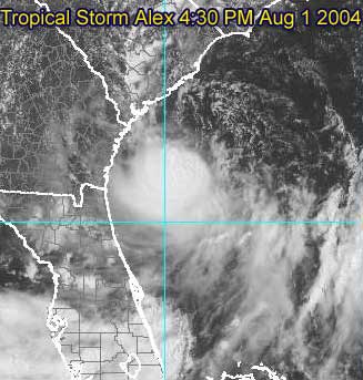
Afternoon visible of Alex with broad center partially exposed
The National Hurricane Center track carries Alex north and northeastward just off the coast of South Carolina, over Cape Fear and Carteret County, North Carolina, and then very close to Cape Hatteras.
Any minor deviation from this path could either result in the storm never making landfall, or a track over the coastal counties of the Carolinas. Specifically, deviation to the left would result in tropical storm conditions outside of the current warning area, so people in the watch area and perhaps as far down the coast as Savannah should keep this in mind.
Alex information:
Event Related Links
Charleston, SC Long Range Radar
Jacksonville, FL Long Range Radar
Various forecast tracks from earlier model runs, Wunderground.com
General Links
Current Aircraft Recon Info
NRL Monterey Marine Meteorology Division Forecast Track of Active Systems (Good Forecast Track Graphic and Satellite Photos)
Check the Storm Forum from time to time for comments on any new developing system.
Follow worldwide SST evolution here:
Global SST Animation
NASA GHCC Interactive Satellite images at:
North Atlantic Visible (Daytime Only), Infrared, Water Vapor
Some forecast models:
NGM, AVN, MRF, ETA ECMWF
AVN, CMC, GFDL, JMA, NOGAPS, UKMET
DoD Weather Models (NOGAPS, AVN, MRF)
Multi-model plots from WREL
Other commentary at Mike Anderson's East Coast Tropical Weather Center, Independentwx.com, Robert Lightbown/Crown Weather Tropical Update Accuweather's Joe Bastardi (now subcriber only unfortunately), Hurricane Alley North Atlantic Page, Cyclomax (Rich B.), Hurricane City , mpittweather , Gary Gray's Millennium Weather, Barometer Bob's Hurricane Hollow, Snonut,
Even more on the links page.
HF 1956z01august
| LI Phil |
| (User) |
| Sun Aug 01 2004 08:01 PM |

|
|
|
Congrats on producing the new forum, HF

Great commentary.
I posted it on the last thread, but not sure anyone saw it. SHIPS model has Alex at 73 mph in 48 hours and 74 mph in 72 hours. Of course, by that time, Alex will be heading across the pond towards James & Rich.
SHIPS also takes Alex to 60 mph in 24 hours, so folks from Hattaras south to Jax should probably keep a watchful eye on this one. Like some others on this board, I'm not totally convinced of the track across the NC barrier islands, although all the models I've seen take it either that way or even further east.
91L also bears watching down the road. Right now it's chugging along on it's merry way, occasionally flaring up and then dying down.
90L has been taken down by NRL, but anything in the gulf bathtub needs to be monitored.
Cheers,
LI Phil
| HanKFranK |
| (User) |
| Sun Aug 01 2004 08:10 PM |
|
|
|
|
well, it's a start. at least the visible still came up pretty. sorry about the URL failure folks, ed warned me it was tricky. i'll update the thread in a while and get them working then. they're A-ok on the older threads.
HF 2010z01august
| Unregistered User |
| (Unregistered) |
| Sun Aug 01 2004 08:26 PM |
|
|
anyone else notice the spin that seems to be developing in the central GOM around 26/89?
| James88 |
| (Weather Master) |
| Sun Aug 01 2004 08:42 PM |

|
|
|
The latest advisory puts Alex up to 45kts in 24 hours and maintains that throughout the forecast period. While it is no longer predicted to make landfall, it is expected to come very close to the coastline, so tropical storm warnings are still in force. The tropical storm warning is extended southwards and now extends from South Santee River SC to Cape Hatteras NC - including the Pamlico Sound.
| Robert |
| (Weather Analyst) |
| Sun Aug 01 2004 08:48 PM |

|
|
|
Alex wont strengthen much unless one of its three to possibly 4 centers take over. And that will not happen untill its center gets under the deep convection displaced to the Southwest.
| Robert |
| (Weather Analyst) |
| Sun Aug 01 2004 08:59 PM |
|
|
|
|
For those who have forgotten this is what a healthy Tropical Storm looks like
Tropical Strom Dennis
Added by ED:
Use the URL capability to put a link to an image in your posts - do not put large images in your post - it uses too much bandwidth. Small images (or a downsized image) are okay. Remember, if a site Administrator or Moderator modifies your post it is for a good reason - so please keep this in mind before you re-edit what they have corrected.
Thanks.
Ed Dunham
CFHC Administrator
| Rich B |
| (British Meteorologist) |
| Sun Aug 01 2004 09:31 PM |
|
|
Well it seems like Alex hasnt really wanted to play ball today. Looking weak and unorganised at first he strengthened to a 40 mph Tropical Storm. He has been going to move to the north or north-northeast; but doesnt seem to have quite got the message yet as he isnt going anywhere fast. And now it looks like he might strengthen some more.
The satellite appearance is improving, and there is no some evidence of a little outflow extending northeast from the area of convection. As the NHC say this indicates upper-level conditions are becoming more favourable, but interestingly the intensity forecast call for him to strengthen to 45 knots, and no higher. I think it may be that Alex could strengthen a little more than forecast, as long as he keeps off the coast.
| James88 |
| (Weather Master) |
| Sun Aug 01 2004 09:34 PM |
|
|
|
|
I agree Rich. As long as Alex stays far enough away from the coast, I think he could reach 50kts or so (possibly a little more). Being over the Gulf Stream with some favourable conditions forecasted within the next 24 hours could work in Alex's favour.
| LI Phil |
| (User) |
| Sun Aug 01 2004 09:43 PM |
|
|
|
|
Actually, ever since Alex got named, he hasn't behaved as the NHC has thought. My gut (and that's all it is) feeling is that he hangs out (stationary) for the time being, before beginning a slow north, then northeast jog. I think the center stays off the coast (just barely), and convection really begins to wrap around the east and northeast quadrants. Folks along the SC and NC beaches will be in for quite a bit of nasty weather.
Cantore is in Wrightsville Beach, NC, so you have to figure the storm will eventually get fairly close to him in the next 24-36 hours. Visibles from there today showed pretty heavy surf and beautiful sunshine, but that's going to change in short order.
As far as intensity, I think this is somewhere in between SHIPS (60 mph @ 24 Hours) and NHC (40 mph); I'll say Alex gets up to 50+ mph in the next 24 hours or so.
Remember, he got named before NHC thought he would (although it should have been fairly apparent he'd get named sooner--hey, if I can see that coming, then they sure should have
 ).
).A'ight [tm by HF], that's my take. Probably be wrong as usual but Alex aint misbehavin'.
| James88 |
| (Weather Master) |
| Sun Aug 01 2004 10:03 PM |
|
|
|
|
Looks like there is some deeper convection building up nearer to the centre of Alex. Maybe he'll be up to 40kts at the next advisory.
| HanKFranK |
| (User) |
| Sun Aug 01 2004 10:04 PM |
|
|
|
|
robert is a very astute fellow. what he can't seem to spell out he uses pictures to convey, so now we all know what a mature tropical storm looks like. i'm sure nobody could tell the difference between alex and a tropical storm in optimal strengthening conditions. mike took the oversize image down, but robert is really intent on letting us see it anyway. so, thank you, robert. t.s. dennis lurks above, yet again.
maybe mike will nix it once more, but i'm personally going to leave it up as an example of what not to do.
addon: it was gone again before i finished my post. but you can always click the link. it's a really nice false-color shot.
HF 2206z01august
| LI Phil |
| (User) |
| Sun Aug 01 2004 10:11 PM |
|
|
|
|
I'm going to second HF's message, and thank you Ed, for removing the oversized image which screwed up the boards.
Robert,
if you're out there. I'M THE ONE who PMed Mike and asked him to scale down (he actually turned it into a URL) your image...because I would have had to delete it.
Well Mike did that and you still saw fit to put it back up. I've also alerted HF and Ed to your behavior and they took action as well.
Pull another stunt like this and it will be your last post, I can assure you of that. That was completely uncalled for behavior and it will not be tolerated on these boards. This was not the first instance or an isolated event. You have been given fair warning.
LI Phil
| HanKFranK |
| (User) |
| Sun Aug 01 2004 10:15 PM |
|
|
|
|
were alex a bit stronger i'd try and take tomorrow off and head down to georgetown or myrtle beach in the morning. the structure is so iffy there's no guarantee there'd be anything other than occasional showers and a stiff breeze. a seabreeze front/feeder band is onshore in the low country right now and obs down there aren't showing more than typical afternoon summer weather. the outer banks have a better shot at seeing some squalls.
HF 2215z01august
| James88 |
| (Weather Master) |
| Sun Aug 01 2004 10:15 PM |
|
|
|
|
Look at the impressive circular appearance Alex has now taken on. Perhaps signs of weakening shear - but could this also be a sign of the centre reforming? Whatever the case, Alex looks like he is on the brink of some good intensification, and the longer he is over water, the more serious the situation could get.
| LoisCane |
| (Veteran Storm Chaser) |
| Sun Aug 01 2004 10:30 PM |

|
|
|
If Alex had the color..storms that we had in Miami just now sitting over his little heart.. he'd be looking like that real nice well developed tropical storm.
One of the strongest electrical storms I've seen down here in a long, long while. All of Florida was lit up in darker shades of red than anything in Alex.
Suppose if some of the warm moisture can wrap into him he could intensify nicely.
Storm is coming back down here.
Seems like everyone on the East Coast got rain today except those nice beach shots on CNN and TWC where they are explaining that even tho its not raining they do have rip currents.
Yup.. Alex is a brat all right.
| Frank P |
| (Veteran Storm Chaser) |
| Sun Aug 01 2004 11:00 PM |
|
|
Been watching the GOM for the past two days. Watching the vis sat loop during the past hours sure appears to hint of a developing mid to upper level circulation at ~26.2n and ~89.0w, with convection on the rise off the east side of the center... several others have mentioned this possiblility on this board and on storm2k, but I've only been able to discern this rotating feature during the past hour or so... area buoy data, nor vis sat pixs do not support any low level circulation in this area however
| teal61 |
| (Weather Hobbyist) |
| Sun Aug 01 2004 11:24 PM |
|
|
Frank P, it's good to hear from ya. I had to go to the NASA GHCC site to find it, but I think I see what you are talking about. Due east of Brownsville and due south of the mouth of the Mississippi you can pick out some of the lower cloud elements moving from west to east. I think there might be a trough extending from Alex across Florida through the central GOM and I wouldn't be surprised at all to see something close off down there. Too much activity in the Gulf to ignore. What's left of 90L is in the western GOM southeast of Brownsville and I don't think it will be a factor at this point.
| Unregistered User |
| (Unregistered) |
| Sun Aug 01 2004 11:32 PM |
|
|
been watchin vis....and looks like storms are still blowing up this evening. Doesn't seem like Alex wants to head to the carloina shores anytime soon.....the last few hours of sat shots looking real good..... could the reforming center be moving little due-east of north?
pressure at Station 41008 - GRAYS REEF - 40 NM Southeast of Savannah, GA....keeps falling all day and this evening.....
i wish the they could get the SABSOON Tower Data back online..... we get some good readings of the storm.......REAL-TIME data too......(not to mention close to "center"of alex)
http://www.skio.peachnet.edu/research/sabsoon/tower.php
| Tropics Guy |
| (Storm Tracker) |
| Sun Aug 01 2004 11:37 PM |

|
|
|
Well, been away from the computer for awhile, and nice to see that our season has finally started with Alex, tonight it looks , at least fron the sat pics that he may be strengthening.
A trailing trough indirectly associated with alex brought severe storms here in the south fla area today, and more expected tomorrow.
91L in the atlantic is still holding on, and seems like convection may be on the increase, haven't checked the long-range models yet to see if it'll make it to the windwards and go into the Carib or further north towards the leeward islands and brush by the northern islands., in any case that is still a few days away, if in fact it holds together.
Oh yea, wanted to say congrats to HankFrank for becoming a moderator on this site, well deserved indeed!, and happy birthday old sailor.

TG
danielw
|
| (Moderator) |
| Sun Aug 01 2004 11:51 PM |

|
|
|
Good eye Frank. That may be the E half of 90L. About midnite last night it did a split. W half moved toward Tampico at 10-15kts. E half was drifting slighly N most of the nite. The dry area N of the circ. is consistant with what we saw last nite. I don't see any reflection in the GMX buoys, but then I don't really see anyhting off JAX to indicate Alex is there. Strange pressure gradients.
| Frank P |
| (Veteran Storm Chaser) |
| Sun Aug 01 2004 11:52 PM |
|
|
Hey teal61, thanks, and I agree with you about 90L which never did get its act together since developing the broad LLC off the coast of SW FL and whats left of it, if you can find it, is in the western GOM. Sorry about not putting up the vis sat loop link, my bad, but you used the same one I did, the NASA GHCC site. I'm certainly not saying anything is imminent in the GOM, but you get some disturbed weather lingering around long enough, and its August, anything is possible.
| Frank P |
| (Veteran Storm Chaser) |
| Mon Aug 02 2004 12:01 AM |
|
|
Yeah Danielw, my good Mississippi neighbor to the north, being a USM alumni I'm quite familar with Hattiesburg.
I noticed the same thing last night as well, the split, and the eastern half drifting north to nnw. I've been trying to find a circulation all day and late this evening is the closest I got to finding anything hinting of a circulation. You get that much disturbed weather in the GOM, you just have to monitor it for some kind of circulation.... something for us to watch over the day or so... People on the east coast have the main action this evening.... Alex might just surprise a few people before its all said and done.
| Unregistered User |
| (Unregistered) |
| Mon Aug 02 2004 12:01 AM |
|
|
been on web last hrs or so and looking at Upper-Level Wind Shear..... notice -3hrs and -3hrs before..... the anticyclonic flow (near SE GA, not to far from Alex) looks like it will make it to the storm overnight and set-up for an interesting night and early morning......
not to mention alex is right over the Gulf Stream and shallow water (100m-800m)......
could alex become a strong TS by morning/maybe cat 1 hurr?
landfall doesn't look like it will happen on the storm......
http://cimss.ssec.wisc.edu/tropic/real-time/atlantic/winds/wg8shr.html
(-3hrs a few times) and forward
| Unregistered User |
| (Unregistered) |
| Mon Aug 02 2004 12:09 AM |
|
|
WTNT31 KNHC 012344
TCPAT1
BULLETIN
TROPICAL STORM ALEX INTERMEDIATE ADVISORY NUMBER 5A
NWS TPC/NATIONAL HURRICANE CENTER MIAMI FL
8 PM EDT SUN AUG 01 2004
...ALEX STATIONARY...WATCHES AND WARNINGS EXTENDED...
A TROPICAL STORM WARNING REMAINS IN EFFECT FROM SOUTH SANTEE RIVER
SOUTH CAROLINA TO CAPE HATTERAS NORTH CAROLINA...INCLUDING THE
PAMLICO SOUND. A TROPICAL STORM WARNING MEANS THAT TROPICAL STORM
CONDITIONS ARE EXPECTED WITHIN THE WARNING AREA WITHIN THE NEXT 24
HOURS.
A TROPICAL STORM WATCH REMAINS IN EFFECT FOR NORTH OF CAPE HATTERAS
TO OREGON INLET NORTH CAROLINA. A TROPICAL STORM WATCH ALSO
REMAINS IN EFFECT FROM EDISTO BEACH TO SOUTH SANTEE RIVER SOUTH
CAROLINA.
AT 8 PM EDT...0000Z...AIR FORCE RESERVE RECONNAISSANCE REPORTS
INDICATE THE CENTER OF TROPICAL STORM ALEX WAS LOCATED NEAR
LATITUDE 31.5 NORTH... LONGITUDE 79.2 WEST OR ABOUT 90 MILES
SOUTH-SOUTHEAST OF CHARLESTON SOUTH CAROLINA.
ALEX REMAINS STATIONARY. HOWEVER...A SLOW DRIFT TOWARD THE NORTH OR
NORTH-NORTHEAST IS EXPECTED LATER TONIGHT OR ON MONDAY. ON THE
FORECAST TRACK...THE CENTER OF ALEX WILL BE SLOWLY APPROACHING THE
SOUTH AND NORTH CAROLINA COASTS OVER THE NEXT 24 HOURS.
MAXIMUM SUSTAINED WINDS ARE NEAR 40 MPH...WITH HIGHER GUSTS.
CONDITIONS FAVOR SOME SLOW STRENGTHENING OVER THE NEXT 24 HOURS.
TROPICAL STORM FORCE WINDS EXTEND OUTWARD UP TO 60 MILES...MAINLY
IN SQUALLS TO THE SOUTH AND EAST OF THE CENTER.
THE ESTIMATED MINIMUM CENTRAL PRESSURE IS 1009 MB...29.80 INCHES.
RAINFALL ACCUMULATIONS OF 1 TO 2 INCHES...WITH ISOLATED HIGHER
AMOUNTS...CAN BE EXPECTED IN ASSOCIATION WITH ALEX.
REPEATING THE 8 PM EDT POSITION...31.5 N... 79.2 W. MOVEMENT
...STATIONARY. MAXIMUM SUSTAINED
WINDS... 40 MPH. MINIMUM CENTRAL PRESSURE...1009 MB.
FOR STORM INFORMATION SPECIFIC TO YOUR AREA...PLEASE MONITOR
PRODUCTS ISSUED BY YOUR LOCAL WEATHER OFFICE.
THE NEXT ADVISORY WILL BE ISSUED BY THE NATIONAL HURRICANE CENTER
AT 11 PM EDT.
FORECASTER STEWART
|
danielw
|
| (Moderator) |
| Mon Aug 02 2004 12:12 AM |
|
|
|
|
Waiting on update. Buoy 42001 is indicating baro. "falling rapidly". Shows a 3.4mb drop over 3hrs. 1015.6 to 1012.2 from 20z to 23z. Wind dropped from 15.7 kts to 5.2 kts in 45 mins.
Buoy located at 25.84N and 89.66W. Should be at or near the circ. FrankP was describing.
01/23 42001 25.8 -89.7 aT27.9 dpt24.6 w230at 6 G 6 pkG180at17kt bar1012.2 -3.4mb/3hr seaT30.7 wv ht1.0 wv pd5
| Unregistered User |
| (Unregistered) |
| Mon Aug 02 2004 12:15 AM |
|
|
1006 mb and observed 50kts winds?.......
http://www.nhc.noaa.gov/text/MIAREPNT2.shtml?
| LI Phil |
| (User) |
| Mon Aug 02 2004 12:34 AM |
|
|
|
|
Latest Dvorak's still at 2.0/2.0. I wouldn't expect much further strengthening overnight with Alex.
As far as the GOM, don't write off 90L just yet. Anything in that warm a water always has a chance...
91L "too weak", so it's got a long way to go.
Tomorrow will be make or break for those two systems, and I expect Alex to get above 50 mph.
|
danielw
|
| (Moderator) |
| Mon Aug 02 2004 12:43 AM |
|
|
|
|
Noticing a rather strong buildup in the NE quad-finally. I think East Coast residents ought to be glad that Alex is in near shore enviroment. Inflow seems to be messing up the storm machine. Consistant Recon reports of Max Wind in SE quad.
I think I may have jumped the gun on the buoy pressure drop in the GMX. It's still showing a more than diurnal pressure drop, but not much else.
| Storm Cooper |
| (User) |
| Mon Aug 02 2004 01:14 AM |
|
|
I see Alex at about it's max... not much more? The GOM... always possible but not real keen on it now... looking east young man!
| Unregistered User |
| (Unregistered) |
| Mon Aug 02 2004 01:41 AM |
|
|
Uhh, no one seems to have noticed...the recon prssure has fallen RAPIDLY, 996mb!!! Wasn't the last advisory 999?? And 50kt flight level winds, they are saying 45kts at the surface...so, Alex wil probably be 50 mph at 11pm.
Looking at the IR, seems it is still stationary, and may be reforming to the s.....
sc

Agree with other posters re: Gulf...too much energy there and too much going on....88degree water temp at St. Makrks, and a report was relayed to me Friday of 91 (NINETY ONE!) degree water temps in SW Fl...! Have to watch the Gulf closely.
|
danielw
|
| (Moderator) |
| Mon Aug 02 2004 02:03 AM |
|
|
|
|
I don't see any reports, anywhere of 999mb. Last vortex report was 1008mb with a Max Wind of 45kt in SE quad, at 0119Z or 9:19pm EDT.
What source are you using for your reports?
| hurricane_run |
| (Storm Tracker) |
| Mon Aug 02 2004 02:38 AM |

|
|
|
000
WTNT31 KNHC 020226
TCPAT1
BULLETIN
TROPICAL STORM ALEX ADVISORY NUMBER 6
NWS TPC/NATIONAL HURRICANE CENTER MIAMI FL
11 PM EDT SUN AUG 01 2004
...ALEX REMAINS STATIONARY OFF THE SOUTH CAROLINA COAST...
A TROPICAL STORM WARNING REMAINS IN EFFECT FROM SOUTH SANTEE RIVER
SOUTH CAROLINA TO CAPE HATTERAS NORTH CAROLINA...INCLUDING THE
PAMLICO SOUND. A TROPICAL STORM WARNING MEANS THAT TROPICAL STORM
CONDITIONS ARE EXPECTED WITHIN THE WARNING AREA WITHIN THE NEXT 24
HOURS.
A TROPICAL STORM WATCH REMAINS IN EFFECT FOR NORTH OF CAPE HATTERAS
TO OREGON INLET NORTH CAROLINA. A TROPICAL STORM WATCH ALSO
REMAINS IN EFFECT FROM EDISTO BEACH TO SOUTH SANTEE RIVER SOUTH
CAROLINA.
AT 11 PM EDT...0300Z...THE CENTER OF TROPICAL STORM ALEX WAS
LOCATED NEAR LATITUDE 31.5 NORTH...LONGITUDE 79.2 WEST OR ABOUT
90 MILES SOUTH-SOUTHEAST OF CHARLESTON SOUTH CAROLINA.
ALEX REMAINS NEARLY STATIONARY. HOWEVER...A SLOW DRIFT TOWARD THE
NORTH OR NORTH-NORTHEAST IS EXPECTED BY MONDAY AFTERNOON. ON THE
FORECAST TRACK...THE CENTER OF ALEX WILL BE SLOWLY APPROACHING THE
SOUTH AND NORTH CAROLINA COASTS DURING THE NEXT 24 HOURS.
MAXIMUM SUSTAINED WINDS ARE NEAR 40 MPH...WITH HIGHER GUSTS. SOME
STRENGTHENING IS FORECAST DURING THE NEXT 24 HOURS.
TROPICAL STORM FORCE WINDS EXTEND OUTWARD UP TO 60 MILES SOUTHEAST
THROUGH SOUTHWEST OF THE CENTER.
THE ESTIMATED MINIMUM CENTRAL PRESSURE IS 1007 MB...29.74 INCHES.
RAINFALL ACCUMULATIONS OF 1 TO 2 INCHES...WITH ISOLATED HIGHER
AMOUNTS...CAN BE EXPECTED IN ASSOCIATION WITH ALEX.
HIGH SURF AND RIP CURRENTS WILL AFFECT MUCH OF THE SOUTHEASTERN AND
MID-ATLANTIC U.S. COASTAL AREAS FOR THE NEXT COUPLE OF DAYS.
REPEATING THE 11 PM EDT POSITION...31.5 N... 79.2 W. MOVEMENT
...STATIONARY. MAXIMUM SUSTAINED
WINDS... 40 MPH. MINIMUM CENTRAL PRESSURE...1007 MB.
FOR STORM INFORMATION SPECIFIC TO YOUR AREA...PLEASE MONITOR
PRODUCTS ISSUED BY YOUR LOCAL WEATHER OFFICE.
AN INTERMEDIATE ADVISORY WILL BE ISSUED BY THE NATIONAL
HURRICANE CENTER AT 2 AM EDT FOLLOWED BY THE NEXT
COMPLETE ADVISORY AT 5 AM EDT.
FORECASTER STEWART
| hurricane_run |
| (Storm Tracker) |
| Mon Aug 02 2004 02:39 AM |
|
|
|
|
the pressure is droping
| LoisCane |
| (Veteran Storm Chaser) |
| Mon Aug 02 2004 02:43 AM |
|
|
|
|
Debating what to say and think I'm not going to say whats on my mind.
Only will say that Tropical storms are wierd..and weather is not always where the "center" is and sometimes its hard to really see the "center"
Maybe those were straight line winds ??? ok.. being silly.
The thing that amazes me is this.. when you have these storms like IRENE where the core is hard to find and the "weather mass" is a perfectly round blob with perfect symmetry with strongest weather in the middle.. well there has to be a way of handling them that the public understands them.
Weather in South Florida linked all the way back to Alex in some band like/tail (josephine?) and you can't say its not related. yes we have a trough .. an weakness in the atmosphere ...etc.. but curled right in. Maybe all that energy from down south helped strengthen him a drop? If it did..
Personally I think that the wave out there gets an A for tenacity and for maintaining itself in less than perfect conditions. Compells you to pay attention.
Enjoyed Jim/hurricanecity's broadcast tonight. Interesting to hear more about entities that we all use and know of online. A great night to sit in the room, listen to the rain fall and think on where we are going this year and where we have been. Think this is the first of several storms to affect the coastal united states.
Think we all should get ready.. think on what we would do, what our priorities are and make a plan.. because some of us are going to be under the gun.
Thats it.
Nite and keep staring..hoping he won't linger much longer and move on out before he messes things up for a lot of people along the coast who have already had way too much rain lately.
| Old Sailor |
| (Storm Tracker) |
| Mon Aug 02 2004 02:48 AM |

|
|
|
Like I was saying early today , we should be looking to the east for maybe our first Hurricane of the season 4 to 5 days looks to be maybe a cat 1
Dave
| hurricane_run |
| (Storm Tracker) |
| Mon Aug 02 2004 02:54 AM |
|
|
|
|
think it'll be a depressionin 24-48 hrs or later than that?
there also a nice looking wave coming off off africa.
| hurricane_run |
| (Storm Tracker) |
| Mon Aug 02 2004 02:56 AM |
|
|
|
|
look at the wave coming off the coast
http://www.ssd.noaa.gov/PS/TROP/DATA/RT/EATL/IR4/20.jpg
| Jamiewx |
| (Storm Tracker) |
| Mon Aug 02 2004 03:00 AM |

|
|
|
91L seems to be pulling itself together tonight, some colder cloud tops showing up on the IR loop. Wonder what tomorrows T-numbers will be for this one. Even the TWO is looking at the prospect of a Depression from 91L. Looked at the wave coming off Africa too, does anyone see a slight turning in the wave? I thought i did, but i like to be sure.
A note for the Admin Team, not sure if you guys have noticed this, but the Advisory on Alex at the top of the page seems to sort of out-run itself resulting in the advisories not being scrolled across correctly.
| hurricane_run |
| (Storm Tracker) |
| Mon Aug 02 2004 03:01 AM |
|
|
|
|
the 11pm discussion calls for "SOME SIGNIFICANT STRENGTHENING COULD OCCUR MONDAY AND MONDAY NIGHT" nite HR
| hurricane_run |
| (Storm Tracker) |
| Mon Aug 02 2004 03:02 AM |
|
|
|
|
I see some slight turning also. thought it was only me though
| Tropics Guy |
| (Storm Tracker) |
| Mon Aug 02 2004 03:04 AM |
|
|
|
|
From the 10:30 TWO:A VIGOROUS TROPICAL WAVE LOCATED ABOUT 1200 MILES EAST OF THE
WINDWARD ISLANDS IS MOVING WESTWARD AT NEAR 20 MPH. THIS SYSTEM
CONTINUES TO BECOME BETTER ORGANIZED AND CONDITIONS APPEAR
FAVORABLE FOR A TROPICAL DEPRESSION TO DEVELOP DURING THE NEXT
COUPLE OF DAYS.
That was the mid-atlantic wave, and down the road the wave coming off of Africa looks pretty strong, could be another one to watch.
and yes, bobbi, I think that the severe storms that rolled through S. Fla today were indirectly induced by Alex.
TG
|
danielw
|
| (Moderator) |
| Mon Aug 02 2004 03:04 AM |
|
|
|
|
It was large and symmetrical until it hit the water. Yes, there is a circ. in there. Latest outlook indicates shear over the western most wave is decreasing and the convection is moving back over the center.
| Old Sailor |
| (Storm Tracker) |
| Mon Aug 02 2004 03:14 AM |
|
|
|
|
I think if it's going to fire up it be fast like 1 to 2 days TD, next day TS and then Bonnie, also if doesn't make TD by 3 days would most likely stay a wave.
Dave
| joepub1 |
| (Storm Tracker) |
| Mon Aug 02 2004 03:16 AM |
|
|
I agree that the CV season is about to present us with at least one, if not two more features to track. But first I'll say for a TS that appears to be getting stronger, and the pressure is down to 1007 mb, you can't tell by being here in Jax. Hardly any rain today, very warm, slight but steady N/NW wind. You just couldn't con me into believing that there was a TS out there if I didn't know it. More weather yesterday when it was east of here instead of NE for sure. But he does look more like a classic baby TS now then he did. Not bad for the first one of the season.
The models already are killing me in the deep atlantic. The AVN had twins forming before the islands four, five runs ago, I swear. Now it has backed off of that, yet it seems that is what might happen. 91L is giving another burst tonight, and the TPC says a depression could form in the next day or two. But I think it's the wave that came off Africa today that most models are giving some kind of chance to form. Most miss the first one, but it looks OK to me. Chances are we may get two though. If 91lL develops, then the future 92L (or 93L, what's going on in the SE GOM???) should develop also IMO. The bigger picture shows the BH weaking as Alex moves up the coast, allowing some northwest movement of 91L, but then the door seems to shut again before it can get away. 91L is down around 11-12 N anyway; it has alot of room to work with. Todays wave seemed a tad bit higher, but the door should shut long before it gets developed ( if it does). We should keep one one peeking out that way for the next couple of days.
| HanKFranK |
| (User) |
| Mon Aug 02 2004 03:49 AM |
|
|
|
|
not a bad post title. think i'll borrow it.
everything of interest in the atlantic is getting better organized this evening. aside from alex only 91L is on the verge of development at this point. rather than recap i'll add my spin to the mix.
alex is getting better organized, plain and simple. taking into account that shear is decreasing and the storm is over the gulf stream, this makes plenty of sense. so now it has an intact cdo, which means alex will probably not remain dinky and laughable for too much longer. the nhc is sticking to their near/just offshore track while backpedaling on the timetable, as the storm continues to wobble around in place (actually drifted south some today). with the increased organization and the fact that conditions will continue to improve, i expect alex to be knocking on hurricane strength by tomorrow afternoon. it may do some emergency ridge-pumping as that shortwave moves in, and have to jerk left around it.. maybe come ashore monday night or tuesday just a little. just a thought, since some of the others have worked.
91L, as mentioned continues to draw looks. ssd had it as 1.0 earlier, now it's back to TW.. but the scant convection earlier is more robust tonight. there's even a reverse arc to the thunderstorm exhaust that suggests outflow. while it's speed suggests that only a mid-level vorticity max and surface hairpin in the trades exist, it is slowly decelerating. the arc of convection north/west of the vortmax and along the itcz suggest it means business. at around 11N it has the sort of trajectory that would spell trouble for the islands, and the globals are slowing it down (still not calling for much development though). model support or no, if this system were moving at 15mph it would probably be a depression, and it should have slowed to near there by tuesday.. it has good chances of being t.d. 2.
behind 91L is another, system, and invest not yet dubbed. gfs has been making a fish spinner out of this for almost a week.. and it's come off looking good. all those phantom systems we were mentioning last week coming out into the MDR are insisting they are real.
old 90L remnants have a weak hook of convection but nothing going for it. away east is diffluence-generated convection that is sort of trained into alex. doubt the degree of separation exists for that to do anything.
heed the mid-level system near 23/57 following the periphery of the ridge. it's one of those shortwave fragments that loop around the ridges and sometimes start stuff. globals have seen it for days and made it look interesting. a watcher at least.
odd sidenote.. td six is coming back to life in the eastpac.
the developing pattern in the eastern u.s. is one that will close the east coast to the tropics late week through next weekend, but then leave it wide open into the following week. that's if consecutive gfs runs are telling the truth about the behavior of the longwaves extending from the arctic.
if we get MDR development it will be interesting times ahead.
HF 0349z02august
| Cycloneye |
| (Storm Tracker) |
| Mon Aug 02 2004 04:04 AM |
|
|
Great post as always HF.About 91L agree that it looks to be TD#2 tommorow or the next day.Still it has to contend with sal out there but that has faded compared with past weeks so I give 91L a 60% to develop and of course from here in Puerto Rico I am watching it very closely.
|
danielw
|
| (Moderator) |
| Mon Aug 02 2004 04:17 AM |
|
|
|
|
The KJAX Nexrad Profiler is starting to show an area of 20-25kt northerly winds creeping into the area for the last hour. Between 25-30K ft.
Is this more indicative of the storm diameter increasing westward, or just some slight change in the dynamics?
Winds from 11-24,000 ft are No Data, and the winds from 2K-10k and mostly NW at 25-30kts.
Looks like Jax may be windy tomorrow!
http://weather.cod.edu/analysis/paulradar.pl?JAX
|
Ed Dunham
|
| (Former Meteorologist & CFHC Forum Moderator (Ed Passed Away on May 14, 2017)) |
| Mon Aug 02 2004 04:48 AM |
|
|
To see what danielw is talking about, under 'Other Products', click on VAD. The Velocity Azimuth Display is a product derived from the radar data (not really a true Profiler). The missing data areas are simply areas where there were no reflectors such as cloud, precip, dust, etc., to create a radar return signal. A real neat link - thanks Daniel.
Cheers,
ED
|
danielw
|
| (Moderator) |
| Mon Aug 02 2004 05:03 AM |
|
|
|
|
Thanks Ed,
I should have given an explanation on how to access the data. Actually the only product that this site is missing is the long range radar. I use it mostly for convective systems in the states. Thought you all might like to try it out. Good luck.
Danny
|
danielw
|
| (Moderator) |
| Mon Aug 02 2004 05:42 AM |
|
|
|
|
Here's a Sat link that you can watch Alex and 91L on. Links at the top switch from IR to WV, etc.
http://weather.msfc.nasa.gov/GOES/goeseasthurrir.html
| Joe |
| (Storm Tracker) |
| Mon Aug 02 2004 05:49 AM |
|
|
Alex getting much better organized. Looking at the radar and satellite loops storm structure is improving quite a bit and could be on it's way to a strong TS today. Still sitting nearly stationary over the warm gulf stream and I expect this to continue through first half of Mon before a NNE-NE movement is made as trough approaches from west.
|
danielw
|
| (Moderator) |
| Mon Aug 02 2004 05:56 AM |
|
|
|
|
URNT12 KNHC 020510
VORTEX DATA MESSAGE
A. 02/0510Z
B. 31 DEG 22 MIN N
79 DEG 27 MIN W
C. 850 MB 1470 M
D. NA
E. NA
F. 139 DEG 40 KT
G. 029 DEG 44 NM
H. 1005 MB 1005 MB
I. 19 C/ 1562 M
J. 20 C/ 1567 M
K. 15 C/ NA
L. NA
M. NA
N. 1 345/8
O. 0.1/ 15 NM
P. AF861 0501A ALEX OB 19
MAX FL WIND 40 KT NE QUAD 0457Z. MAX FLT TEMP 20C 022/33NM FROM
FL CNTR
| James88 |
| (Weather Master) |
| Mon Aug 02 2004 06:57 AM |
|
|
|
|
Well, Alex now has a T-number of 3.0 - so perhaps it will be bumped up to 45 kts at the next advisory. Also, 91L now has a T-number of 1.5.
|
danielw
|
| (Moderator) |
| Mon Aug 02 2004 07:22 AM |
|
|
|
|
Alex's outflow to the N and NE seems to be getting better organized. WV loop indicates it may be pushing against the dry air slot on the N side.
Wave 91L-Thunderstorms have a cobblestone appearance on the periphery of the circ. Almost fully wrapped by these thunderstorms. There appears to be a LLCC, with thunderstorms rotating around it. The northern half of the circ. is complete with convection. West through S through E hasn't completed the circle, if you will. Rough approximation of movement is 1 degree W in 3 hours or about 20 mph.
Interesting note-GFS model is showing another tropical system nearing the SC and NC coast in about 12-14 days. Looks like a bad year for the East Coast.
AGXX40 KNHC 020642
TROPICAL WAVE CURRENTLY ALONG 42W/43W WITH
ASSOCIATED 1012 MB SFC LOW NEAR 11N43W MOVING W 20 KT.
GFS/NOGAPS/UKMET NOT VERY ENTHUSIASTIC ABOUT THE PROSPECTS FOR
THIS WAVE. HOWEVER...THIS WAVE BEING MONITORED FOR POSSIBLE
DEVELOPMENT GIVEN THE FAIRLY WELL ORGANIZED STRUCTURE TO THIS
SYSTEM. WAVE FORECAST TO MOVE INTO TROPICAL N ATLC OVERNIGHT
TUE/WED AND ALONG 58W EARLY WED.
| James88 |
| (Weather Master) |
| Mon Aug 02 2004 08:42 AM |
|
|
|
|
Once again, Alex is a minimal tropical storm. It is still forecast to reach 50 kts though. Here's the discussion -
Tropical Storm Alex Discussion Number 7
Statement as of 5:00 am EDT on August 02, 2004
on the last recon fix at 0510 UTC...the pressure was down to 1005 mb
but the highest flight-level...850 mb...winds were 46 kt over the
southwest quadrant. Taking the Standard reduction from this level
to the surface still gives 35 kt for the current intensity.
Subsequent surface observations from data buoys suggest that the
central pressure may have dropped a little more. WSR-88D Doppler
radar data suggest that the storm has become a little better
organized but the center is still just to the north of the area of
most intense convection. We are waiting for the next aircraft
mission to see if the winds have increased. Numerical guidance such
as the GFS suggest that the northeasterly shear over the system
should be ending...and that there is about a 24 hour window before
increasing westerly shear affects the tropical cyclone. Therefore
the official forecast shows strengthening up to 24 hours...and the
forecast wind speeds are just slightly higher than the latest SHIPS
guidance.
Recon...satellite...and surface data suggest little motion. Alex is
still embedded within a weakness in the subtropical ridge so the
steering flow is weak to non-existent. However....an approaching
trough in the westerlies is soon expected to provide an increasing
southwesterly steering current...which should accelerate Alex
northeastward. Even though the official track forecast...like the
previous one...keeps the storm offshore the proximity to the coast
dictates that the tropical storm warnings and watches be maintained.
Forecaster Pasch
forecast positions and Max winds
initial 02/0900z 31.4n 79.5w 35 kt
12hr VT 02/1800z 32.2n 79.0w 40 kt
24hr VT 03/0600z 33.4n 77.3w 50 kt
36hr VT 03/1800z 35.3n 74.3w 50 kt
48hr VT 04/0600z 37.5n 70.5w 50 kt
72hr VT 05/0600z 43.0n 59.0w 45 kt...becoming extratropical
96hr VT 06/0600z 49.0n 44.0w 45 kt...extratropical
120hr VT 07/0600z...absorbed
$$
Alex does look better organised, and seems to be spreading out a little over Florida. I was expecting at least an extra 5 knots with this advisory. Oh well. We'll just have to wait for the next recon to see what the situation is.
| Rich B |
| (British Meteorologist) |
| Mon Aug 02 2004 08:58 AM |
|
|
Agree James, the circulation does seem to have expanded towards the west, and is now affecting both parts of Florida and Georgia. With the pressure now down to 1004 mb, it normally follows that the winds will increase, so expect to see a stronger storm possibly at the 12z advisory if not at the 15z advisory. Based on the improving organisation, Alex seems to be taking benefit of the improving upper-level conditions too. I think recon will find a stronger storm when they go in this morning.
|
danielw
|
| (Moderator) |
| Mon Aug 02 2004 09:05 AM |
|
|
|
|
We've got about 2 hrs before the plane departs, looks like it's scheduled to be in Alex at 12Z. I'll be surprised if they find much change on the first leg. The sunrise should boost it up a bit again.
ATLANTIC REQUIREMENTS
1. TROPICAL DEPRESSION ONE
FLIGHT ONE
A. 02/1200,1800Z
B. AFXXX 0601A CYCLONE
C. 02/0845Z
D. 34.7.0N 77.8W
E. 02/1100Z TO 02/1830Z
F. SFC TO 10,000 FT
|
danielw
|
| (Moderator) |
| Mon Aug 02 2004 09:30 AM |
|
|
|
|
ABNT20 KNHC 020853
530 AM EDT MON AUG 2 2004
A VIGOROUS TROPICAL WAVE LOCATED ABOUT 1000 MILES EAST OF THE
WINDWARD ISLANDS IS MOVING WESTWARD NEAR 20 MPH. THIS SYSTEM
CONTINUES TO SHOW SIGNS OF ORGANIZATION...AND IT HAS THE POTENTIAL
FOR TROPICAL CYCLONE FORMATION OVER THE NEXT COUPLE OF DAYS.
|
danielw
|
| (Moderator) |
| Mon Aug 02 2004 09:36 AM |
|
|
|
|
What a differance a 6 hours makes!
DATE/TIME LAT LON CLASSIFICATION STORM
02/0545 UTC 11.0N 43.5W T1.5/1.5 91
02/0545 UTC 32.0N 79.6W T3.0/3.0 ALEX
01/2345 UTC 32.0N 79.0W T2.0/2.0 ALEX
01/2345 UTC 10.3N 40.6W TOO WEAK 91
01/1745 UTC 10.1N 39.2W TOO WEAK 91
| James88 |
| (Weather Master) |
| Mon Aug 02 2004 09:36 AM |
|
|
|
|
The models take 91L into the Caribbean. Here's a link:-
Model runs on 91L
|
danielw
|
| (Moderator) |
| Mon Aug 02 2004 09:41 AM |
|
|
|
|
Latest Sat on 91L. Think we might have a problem here-Miami!
http://www.ssd.noaa.gov/PS/TROP/DATA/RT/WATL/IR4/20.jpg
|
danielw
|
| (Moderator) |
| Mon Aug 02 2004 09:52 AM |
|
|
|
|
Looks like the Caribbean is Not the place to be this week!
|
danielw
|
| (Moderator) |
| Mon Aug 02 2004 10:11 AM |
|
|
|
|
Here's the first VIS pic of 91L from GOES-E. The outflow to the North can be seen. Better shot than the IR and WV.
http://weather.msfc.nasa.gov/GOES/GOES09452004215cqqClO.jpg
| James88 |
| (Weather Master) |
| Mon Aug 02 2004 10:33 AM |
|
|
|
|
Wow, 91L is really looking quite good this morning - perhaps a TD later today. Meanwhile, Alex is looking very impressive.
There is a persistent area of very deep convection, and a high pressure ridge is giving him great outlflow.
|
danielw
|
| (Moderator) |
| Mon Aug 02 2004 10:40 AM |
|
|
|
|
Plane is airborne and found 35kt winds at flight level.
97779 10264 20301 78100 30100 24035 0904/ /3148
RMK AF866 0601A ALEX OB 03
| James88 |
| (Weather Master) |
| Mon Aug 02 2004 12:12 PM |
|
|
|
|
Wow...
Tropical Storm Alex Special Advisory Number 8
Statement as of 8:00 am EDT on August 02, 2004
...Alex strengthens...
Radar imagery and reports from an Air Force reserve unit
reconnaissance aircraft indicate that Alex has begun to strengthen.
A Tropical Storm Warning remains in effect from South Santee River
South Carolina to Cape Hatteras North Carolina...including the
Pamlico Sound. A Tropical Storm Warning means that tropical storm
conditions are expected within the warning area within the next 24
hours.
A tropical storm watch remains in effect for north of Cape Hatteras
to Oregon Inlet North Carolina. A tropical storm watch also
remains in effect from Edisto Beach to South Santee River South
Carolina.
At 8 am EDT...1200z...the center of Tropical Storm Alex was located
near latitude 31.3 north...longitude 79.0 west or about 120
miles...south-southeast of Charleston South Carolina.
Alex has been drifting eastward over the past few hours.
However...a slow motion toward the north or northeast is expected
over the next 24 hours. On the forecast track...the center of Alex
will be slowly approaching the coasts of south and North Carolina
later today.
Maximum sustained winds are near 60 mph...with higher
gusts. Some additional strengthening is expected during the next 24
hours.
Tropical storm force winds extend outward up to 105 miles
...165 km from the center.
An Air Force reserve unit reconnaissance aircraft recently reported
a minimum central pressure of 992 mb...29.29 inches.
Storm total rainfall accumulations of 1-2 inches...with isolated
higher amounts...can be expected in association with Alex.
High surf and rip currents will affect much of the southeastern and
mid-Atlantic U.S. Coastal areas for the next couple of days.
Repeating the 8 am EDT position...31.3 N... 79.0 W. Movement
...Drifting east. Maximum sustained
winds... 60 mph. Minimum central pressure... 992 mb.
For storm information specific to your area...please monitor
products issued by your local weather office.
The next advisory will be issued by the National
Hurricane Center at 11 am EDT.
Forecaster Franklin
Perhaps his chances of becoming a hurricane are on the up.
| javlin |
| (Weather Master) |
| Mon Aug 02 2004 12:14 PM |
|
|
Alex should really start to feel that pressure today to move E and N.The frontal boundry to the W is making a good push.The storm needs more room on the W side to make hurricane strength if it does.The wave out E of the Islands looks really good this morning and the one behind looks like it might form also.The island's look like they are going to be busy for the next couple of weeks.Then their is another wave poised to exit in a few days that looks healthy over land.We will have to see if promises anything for the future.The Cape season seems to be in full swing.I tlooks by James post that it has already begun.
| James88 |
| (Weather Master) |
| Mon Aug 02 2004 12:22 PM |
|
|
|
|
Hurricane Alex?
** WTNT41 KNHC 021212 ***
TCDAT1
TROPICAL STORM ALEX SPECIAL DISCUSSION NUMBER 8
NWS TPC/NATIONAL HURRICANE CENTER MIAMI FL
8 AM EDT MON AUG 02 2004
THIS IS A SPECIAL ADVISORY TO UPDATE THE CURRENT AND FORECAST
INTENSITY OF ALEX. RADAR IMAGERY INDICATES THAT THE CORE OF ALEX
IS BECOMING BETTER ORGANIZED. RECONNAISSANCE AIRCRAFT INDICATE
THAT THE CENTRAL PRESSURE HAS FALLEN TO 992 MB AND THE PEAK 850 MB
WINDS HAVE INCREASED TO 62 KT. THIS IS EQUIVALENT TO ROUGHLY 50 KT
AT THE SURFACE.
THE INTENSITY FORECAST AND THE WIND RADII HAVE BEEN ADJUSTED
UPWARD...AND THE OFFICIAL FORECAST NOW BRINGS ALEX TO JUST BELOW
HURRICANE STRENGTH IN 24 HOURS. THE POTENTIAL IS CERTAINLY
THERE...HOWEVER...FOR ALEX TO STRENGTHEN A BIT MORE THAN SHOWN
BELOW AND BECOME A HURRICANE.
ONLY THE 12-HOUR POSITION FORECAST HAS BEEN MODIFIED FROM THE
PREVIOUS ADVISORY.
FORECASTER FRANKLIN
FORECAST POSITIONS AND MAX WINDS
INITIAL 02/1200Z 31.3N 79.0W 50 KT
12HR VT 02/1800Z 32.2N 78.5W 55 KT
24HR VT 03/0600Z 33.4N 77.3W 60 KT
36HR VT 03/1800Z 35.3N 74.3W 60 KT
48HR VT 04/0600Z 37.5N 70.5W 60 KT
72HR VT 05/0600Z 43.0N 59.0W 55 KT...EXTRATROPICAL
96HR VT 06/0600Z 49.0N 44.0W 45 KT...EXTRATROPICAL
120HR VT 07/0600Z...ABSORBED BY EXTRATROPICAL LOW
If you looked on the radar loops earlier, there was a hint of an eye. This storm is full of surprises!
| cyclone_head |
| (Weather Hobbyist) |
| Mon Aug 02 2004 01:25 PM |

|
|
|
Menacing is a good term to use for Alex. Although for a "home grown" storm he/she looks pretty good. Here is the bouy data for 40 NM Southeast of Savanah.
http://seaboard.ndbc.noaa.gov/station_page.phtml?station=41008
| Unregistered User |
| (Unregistered) |
| Mon Aug 02 2004 01:57 PM |
|
|
There was a report up, but, I think it was an old one that was posted from last year...I reacall it being "01 August", but, it had been on there a year, and I think it came up ont he site (NHC) by mistake. Anyway, Look at Alex this morning (Mon)!
sc
| BillD |
| (User) |
| Mon Aug 02 2004 02:11 PM |
|
|
They were fooling around with the website last night. During the course of an hour the flight vortex info changed back and forth from one with a date/time of "COM TEST COM TEST", to the real one. And the TEST one had lower pressure and higher winds and lat/long somewhere out in the Pacific (although it was listed under Atlantic recon).
Just checked and they are doing it again:
000
URPN12 KNHC 221708
VORTEX DATA MESSAGE
A. COM TEST COM TEST
B. 18 DEG 03 MIN N
149 DEG 27 MIN W
C. 700 MB 3017 M
D. 65 KT
E. 057 DEG 020 NM
F. 144 DEG 68 KT
G. 058 DEG 018 NM
H. 990 MB
I. 10 C/ 3061 M
J. 19 C/ 3041 M
K. 8 C/ NA
L. OPEN SW
M. E09/20/15
N. 12345/7
O. 0.5/2.0 NM
P. AF968 0110E JIMENA OB 15
MAX FL WIND 68 KT NE QUAD 1703Z. COM TEST
Bill
| Unregistered User |
| (Unregistered) |
| Mon Aug 02 2004 04:34 PM |
|
|
if you think those two out over water look good.. take a look at the one still over mid-Africa..
three of the healthiest looking waves ive seen in ages
one has to develop..
as for alex, think if anything they are being overly conservative, waiting to see if he continues his intensification trend.. cant say i blame them..