MikeC
|
| (Admin) |
| Tue Aug 03 2004 02:49 PM |
|
|
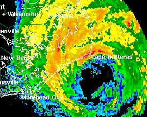
2PM EDT Update - Hurricane Alex:
Radar shows the eyewall over the Outer Banks of North Carolina as Hurricane Alex continues toward the northeast and out to sea at 17mph. Central pressure has been reported as low as 970mb by the Hurricane Hunters. A few locations in the Outer Banks have reported wind gusts in excess of 80mph.
ED
Original Post:
Hurricane Alex still is encroaching dangerously close to the outer banks and Cape Hatteras. At 11AM it has a maximum sustained windspeed of 100MPH and now is a category 2 storm.
and...
Tropical Depression #2 has formed east of the lesser Antilles. Moving generally westward. It is forecast to become a hurricane in a few days, and watches may be up for the LesserAntilles as early as this afternoon. It's a fairly fast mover right now.
More to come...
Event Related Links
*BEST BET*Wilmington, NC Long Range Radar Loop
Morehead City, NC Long Range Radar Loop
Norfolk/Wakefield, VA Long Range Radar Loop
Charleston, SC Radar Loop
Charleston, SC Long Range Radar
Jacksonville, FL Long Range Radar
North Carolina Weather Reports
General Links
Current Aircraft Recon Info
NRL Monterey Marine Meteorology Division Forecast Track of Active Systems (Good Forecast Track Graphic and Satellite Photos)
Check the Storm Forum from time to time for comments on any new developing system.
Follow worldwide SST evolution here:
Global SST Animation
NASA GHCC Interactive Satellite images at:
North Atlantic Visible (Daytime Only), Infrared, Water Vapor
LSU Sat images
Some forecast models:
NGM, AVN, MRF, ETA ECMWF
AVN, CMC, GFDL, JMA, NOGAPS, UKMET
DoD Weather Models (NOGAPS, AVN, MRF)
Multi-model plots from WREL
Other commentary at Independentwx.com, Robert Lightbown/Crown Weather Tropical Update Accuweather's Joe Bastardi (now subcriber only unfortunately), Hurricane Alley North Atlantic Page, Cyclomax (Rich B.), Hurricane City , mpittweather , Gary Gray's Millennium Weather, storm2k, Barometer Bob's Hurricane Hollow, Snonut,
Even more on the links page.
| LI Phil |
| (User) |
| Tue Aug 03 2004 02:53 PM |

|
|
|
Well, I stand corrected. NRL still lists TD2 as 91L, but I guess that's about to change...
Just as Alex is about to clear NC, we may have Bonnie. Woo-hoo. Although for the folks in the Islands, they might not be too excited about that.
wunderground
Alex
|
danielw
|
| (Moderator) |
| Tue Aug 03 2004 03:07 PM |

|
|
|
Does this mean it's 2 for Tuesday? Cat 2 and TD2.
| SirCane |
| (Storm Tracker) |
| Tue Aug 03 2004 03:17 PM |

|
|
|
We better look out for this next one! The season is heating up! Can't believe Alex has hit 100mph!!
| James88 |
| (Weather Master) |
| Tue Aug 03 2004 03:17 PM |

|
|
|
They take TD #2 up to 70kts in 96hrs. Not to be pessimistic Phil, but the track forecast takes it towards your neck of the woods.
| Unregistered User |
| (Unregistered) |
| Tue Aug 03 2004 03:19 PM |
|
|
Quote:
We better look out for this next one! The season is heating up! Can't believe Alex has hit 100mph!!
I am declaring TD2 a fish except for the northern antilles. Stick a hook in it...its off to the hurricane graveyard.
(On the other hand, i declare that Anonymous declarations without explanations are probably about as reliable as some of the models
 )
)
ED
| Cycloneye |
| (Storm Tracker) |
| Tue Aug 03 2004 03:23 PM |
|
|
Where I am here in Puerto Rico already the officials from management and emergency agencies are preparing as the NHC guidance puts the line over Puerto Rico and of course I am preparing too.
| LI Phil |
| (User) |
| Tue Aug 03 2004 03:25 PM |
|
|
|
|
>>> Not to be pessimistic Phil, but the track forecast takes it towards your neck of the woods.
I don't worry about anything before mid to late August, and in September/October I really take notice.
Depending upon TD2's forward speed and motion (way to early to speculate even out to 72 hours), we'll see how strong the trof is and if it picks it up and away, or if it gets entrained in the Bahamas. Could very easily spin the fishes, could threaten Bermuda, heck, it could even stay south of the trof and make trouble for Fla.
I'll go with the models, though, and trust them for now. Alex was unique (well, not unique), but he was (is) a "homegrown" storm, so the models didn't necessarily get a good grip on him, especially as far as intensity. TD2 is a CV storm, so they probably have a better handle on it as to direction, strength, and forward speed.
Gonna be fun to track, hopefully the folks in the Islands, Luis in PR, and Hispaniola don't get whalloped.
| hurricane_run |
| (Storm Tracker) |
| Tue Aug 03 2004 03:30 PM |

|
|
|
look at the NE quad on alex http://www.srh.noaa.gov/radar/loop/DS.p19r0/si.kmhx.shtml
| James88 |
| (Weather Master) |
| Tue Aug 03 2004 03:35 PM |
|
|
|
|
I see the track forecast puts TD #2 as a 50kt storm in your area in 2 days. Of course the intensity forecasts can be prolematic (as Alex has shown us), but it will probably be at about that strength. Good luck with Bonnie, Cycloneye!
| joepub1 |
| (Storm Tracker) |
| Tue Aug 03 2004 03:47 PM |
|
|
For those of you who have a cell phone with internet access here's the URL for the NHC on the small internet:
http://www.nhc.noaa.gov/index.wml
You get everything from updates and maps to recon data as it happens, in very tiny letters and graphs. Not for those with weak eyes, but great for those of us on our dinner break and no access to our home computer.
| Rabbit |
| (Weather Master) |
| Tue Aug 03 2004 04:14 PM |

|
|
|
Alex is forecast to get up to 105 mph, but it may strengthen further. Originally, forecast to 45, reached 60. Then forecast to hit 75; but reached 90.
now its at 100.
could it reach 115??
| Rabbit |
| (Weather Master) |
| Tue Aug 03 2004 04:22 PM |
|
|
|
|
the GFDL brings 92L to a tropical storm in 36 hours
eastern atlantic
| javlin |
| (Weather Master) |
| Tue Aug 03 2004 04:26 PM |
|
|
I just can bite on all the models forecast of 91L thru the N part of the islands yet.TD2 is moving along at good clip due W. I would think that TD2 would have to slow down to make that turn to the N.At 21 mph to the W a definite steering is being applied to the system.If it slows down some today then it will turn probably.I think as of now TD2 is going a little N of the middle of the Islands.
| Unregistered User |
| (Unregistered) |
| Tue Aug 03 2004 04:35 PM |
|
|
!!!!
On radar...
sc

| Unregistered User |
| (Unregistered) |
| Tue Aug 03 2004 04:36 PM |
|
|
I agree javlin, TD #2 is going to stay south of the island. And I don't see it turning that sharply northward. I mean at 21/71, then 30/72! Certainly its possible, but I see it staying further south.

| Unregistered User |
| (Unregistered) |
| Tue Aug 03 2004 04:36 PM |
|
|
"On the other hand, i declare that Anonymous declarations without explanations are probably about as reliable as some of the models
ED"
agreed..
either way.. can't imagine she won't be upgraded by 5 if not sooner.. really wrapped up tight today
as for alex..great show he's putting on
| James88 |
| (Weather Master) |
| Tue Aug 03 2004 04:38 PM |
|
|
|
|
Since the eye of Alex is extremely close to Hatteras, would this count as a direct hit/landfall? It does look as though the westernmost part of the eye may clip land.
| Unregistered User |
| (Unregistered) |
| Tue Aug 03 2004 04:45 PM |
|
|
not sure about the NHC's opinion, but as far as I am concerned, if any part of the eye moves over land, it is a landfall, and if the western eye is over land, Alex will be going in my "landfalls" folder at the end of the year.
the definition of "direct hit" is :
coming within one Radius of Maximum Wind (RMW) to the left of the cyclone center or two RMW to the right of center
foot note in ERIN 1995 nhc prelim report below the track
| Rabbit |
| (Weather Master) |
| Tue Aug 03 2004 04:46 PM |
|
|
|
|
forgot to log in for that post
get kicked off any time i leave the site
Alex is developing an eye on satellite
| cyclone_head |
| (Weather Hobbyist) |
| Tue Aug 03 2004 04:58 PM |

|
|
|
I agree Javlin...If you look at the history of storms over the last 15 years only a couple of paths take that hard turn North. That is....storms that were born in the lower latitudes like TD2. I think this one will move westerly for some time and maybe even get as far west as 90 Longitude. An example of one storm in August that didn't turn north and came from the same neighborhood about this time of year was Andrew in '92. The next 36 to 48 hours will obviously make or break the models. Many conditions factor in as always.
| James88 |
| (Weather Master) |
| Tue Aug 03 2004 05:09 PM |
|
|
|
|
The eye is beginning to become quite distinctive on visible satellite. The NHC have Alex peaking at 105mph, but you can never be sure with this storm. Thanks for the definition Rabbit.
| hurricane_run |
| (Storm Tracker) |
| Tue Aug 03 2004 05:10 PM |
|
|
|
|
in a 1 pm advisory the pressure is down to 970mb
| doug |
| (Weather Analyst) |
| Tue Aug 03 2004 05:11 PM |
|
|
Taking big chance; took one yesterday with regard to this new TD when I said the trough would not dig deeply on its southern end to allow this system to feel it, and I'm sticking to it. Why, and i'm not basing this on anything except trying to discern the progression of the trough toward the east coast: I see the makings of an ULL in the central GOM. If that happens then I don't see the southern part of the trough reaching far enough east to pull the system north.
There is however the remants of last week's trough ahead of it which seems to have a sw-ne axis directly over Hispanola, and that could be why the models pull it abruptly to the north in a couple of days. But as for now it is not as far north as originally thought, due to its speed I think, and the projectd path is already left of where the current runs place it.
Maybe somebody can explain the science in the development of the "wide trough" over the East coast that the NHC is discussing as the influence on the system in 3-4 days. Don't see it so far.
| hurricane_run |
| (Storm Tracker) |
| Tue Aug 03 2004 05:13 PM |
|
|
|
|
from the 1 pm advisory "AN UNOFFICIAL REPORT OF SUSTAINED WINDS OF 50 MPH...WITH A GUST TO
83 MPH...WAS RECENTLY REPORTED FROM OKRACOKE ISLAND. ANOTHER UNOFFICIAL REPORT WAS RECEIVED FROM HATTERAS VILLAGE OF 65 MPH SUSTAINED WINDS WITH A GUST TO 86 MPH."
| Rabbit |
| (Weather Master) |
| Tue Aug 03 2004 05:17 PM |
|
|
|
|
the position advisories seem to be comming in every hour
| hurricane_run |
| (Storm Tracker) |
| Tue Aug 03 2004 05:20 PM |
|
|
|
|
it was an actual advisory. the next one come at 3pm instead of 2. there was a 12 pm position estimate if thats what you mean.
| James88 |
| (Weather Master) |
| Tue Aug 03 2004 05:21 PM |
|
|
|
|
Check out the radar - Hatteras now looks like it is just sticking out into the eye:-
Alex's eye
| doug |
| (Weather Analyst) |
| Tue Aug 03 2004 05:24 PM |
|
|
Is there some debate on whether or not this qualifies as a land falling storm?
| LI Phil |
| (User) |
| Tue Aug 03 2004 05:31 PM |
|
|
|
|
Is the eye just clipping Hattaras? I'll report, you decide:
Alex at Landfall?
And, as for Bonnie, anyone agree with this track:
Bonnie
| James88 |
| (Weather Master) |
| Tue Aug 03 2004 05:41 PM |
|
|
|
|
URNT12 KNHC 031708
VORTEX DATA MESSAGE
A. 03/1708Z
B. 35 DEG 08 MIN N
75 DEG 27 MIN W
C. 700 MB 2834 M
D. N/A
E. N/A
F. 123 DEG 79 KT
G. 030 DEG 016 NM
H. 972 MB
I. 10 C/ 3134 M
J. 19 C/ 3143 M
K. 13 C/ NA
L. CLOSED
M. C25
N. 12345/7
O. 0.1/ 2 NM
P. AF966 0801A ALEX OB 32
MAX FL WIND 98 KT SE QUAD 1614Z.
Notice that Alex's pressure has gone up by two Mb, so any significant intensification looks a little less likely.
|
Ed Dunham
|
| (Former Meteorologist & CFHC Forum Moderator (Ed Passed Away on May 14, 2017)) |
| Tue Aug 03 2004 05:41 PM |
|
|
Here is an example of what I think that Rabbit was referencing:
HURRICANE ALEX POSITION ESTIMATE
NWS TPC/NATIONAL HURRICANE CENTER MIAMI FL
12 PM EDT TUE AUG 03 2004
AT 12 PM EDT THE CENTER OF HURRICANE ALEX WAS ESTIMATED NEAR
LATITUDE 34.9 NORTH...LONGITUDE 75.6 WEST OR ABOUT 25 MILES SOUTH
OF CAPE HATTERAS NORTH CAROLINA.
FORECASTER FRANKLIN
They are issued during the hours when an Advisory is not being issued and the storm is close to land. Data source is normally radar.
ED
| Rabbit |
| (Weather Master) |
| Tue Aug 03 2004 05:42 PM |
|
|
|
|
remember yesterday that the pressure around midday rose a few millibars
| James88 |
| (Weather Master) |
| Tue Aug 03 2004 05:47 PM |
|
|
|
|
I suppose so. Whatever the case, Alex sure looks impressive at the moment on visible satelite. If ever there was a storm that caught us off guard, it was Alex. Perhaps it will intensify slightly, and it's only 15mph away from major hurricane status.
| BillD |
| (User) |
| Tue Aug 03 2004 05:47 PM |
|
|
From the radar images I am looking at, which was from Moorehead City between around 17:10 and 17:40 UTC, the eye seemed to have expanded to include just the tip of Cape Hatteras, almost like Alex was stretching out just to touch land. And right now it looks like Alex is wobbling and the center might go back over land.
Bill
| Old Sailor |
| (Storm Tracker) |
| Tue Aug 03 2004 05:50 PM |

|
|
|
Doug:
Use to be my understanding it was concerned a land fall when the center of the eye hit land. Guess we need to see what NHC calls it.
Dave
| LI Phil |
| (User) |
| Tue Aug 03 2004 05:55 PM |
|
|
|
|
Anyone interested in seeing some Alex video should check it out here...
http://www.hurricanetrack.com/
As we speak, they have some footage in the can and are moving to a new location, so check back often...
| hurricane_run |
| (Storm Tracker) |
| Tue Aug 03 2004 05:57 PM |
|
|
|
|
i thought it was 11mph away. but that eye is devloping.
| hurricane_run |
| (Storm Tracker) |
| Tue Aug 03 2004 05:59 PM |
|
|
|
|
i've been there all morning but cant get the hirt update. says widows media cant connect.
| James88 |
| (Weather Master) |
| Tue Aug 03 2004 06:03 PM |
|
|
|
|
Thanks for the great link Phil!

|
Ed Dunham
|
| (Former Meteorologist & CFHC Forum Moderator (Ed Passed Away on May 14, 2017)) |
| Tue Aug 03 2004 06:12 PM |
|
|
Here is the latest Position Estimate from NHC - probably not a landfall with this one, but certainly very close.
ED
HURRICANE ALEX POSITION ESTIMATE
NWS TPC/NATIONAL HURRICANE CENTER MIAMI FL
2 PM EDT TUE AUG 03 2004
AT 2 PM EDT THE CENTER OF HURRICANE ALEX WAS ESTIMATED NEAR
LATITUDE 35.3 NORTH...LONGITUDE 75.2 WEST OR ABOUT 25 MILES
EAST-NORTHEAST OF CAPE HATTERAS NORTH CAROLINA.
FORECASTER FRANKLIN
| James88 |
| (Weather Master) |
| Tue Aug 03 2004 06:18 PM |
|
|
|
|
Am I the only one in thinking that the future Bonnie is looking a little ragged at the moment. It's probably a temporary thing, but I was just wondering if anyone else felt the same.
| LI Phil |
| (User) |
| Tue Aug 03 2004 06:19 PM |
|
|
|
|
03/1745 UTC 13.4N 55.1W T2.0/2.0 02
03/1745 UTC 35.3N 75.2W T4.5/4.5 ALEX
| Unregistered User |
| (Unregistered) |
| Tue Aug 03 2004 06:20 PM |
|
|
its a hit
I don't know what the official parameters are as I am a little sketchy on that.. not sure I've ever heard exactly.
However there are no strong winds in the eye.. light winds or no winds..but the immediate eye wall is what has the winds and that eye wall has passed over land a few times.
But, I'm sure we will hear from someone here what the rules are..
| James88 |
| (Weather Master) |
| Tue Aug 03 2004 06:22 PM |
|
|
|
|
I must be wrong. Looks like it could be up to 30kts at the next advisory.
| Old Sailor |
| (Storm Tracker) |
| Tue Aug 03 2004 06:28 PM |
|
|
|
|
Ed:
I posted what I use to know as a land fall..(Use to be my understanding it was concerned a land fall when the center of the eye hit land. Guess we need to see what NHC calls it) Is that still the way the NHC calls a land fall?
Dave
| LI Phil |
| (User) |
| Tue Aug 03 2004 06:28 PM |
|
|
|
|
This will be Bonnie at 5:00 pm
| Unregistered User |
| (Unregistered) |
| Tue Aug 03 2004 06:30 PM |
|
|
now if you can find me my favorite unisys water vapor loop, the ramsdis loop and the winning numbers to tomorrow nights lottery .. i'd be even more excited

| LI Phil |
| (User) |
| Tue Aug 03 2004 06:32 PM |
|
|
|
|
Bobbi, on the wv you will see some dry air ahead of it. But it doesn't seem to be impeding it's progress in any way
| James88 |
| (Weather Master) |
| Tue Aug 03 2004 06:35 PM |
|
|
|
|
I think you might be right there, Phil. There's a new burst of convection occuring not far from the centre, so it isn't fizzling out. Will await the 5:00 advisory with great interest.
| BillD |
| (User) |
| Tue Aug 03 2004 06:38 PM |
|
|
NRL has it as 02L NONAME, and I have to agree with you. TD2 is looking good right now.
Bill
| Rabbit |
| (Weather Master) |
| Tue Aug 03 2004 06:40 PM |
|
|
|
|
TD2
the western edge is beginning to show the effects of shear, and if it is not upgraded to a TS by 5 pm (which it will likely not), it will not become a storm.
92L is no longer active as all of the data is more than 12 hours old
Alex continues to look stronger with each passing hour
Alex
| Unregistered User |
| (Unregistered) |
| Tue Aug 03 2004 06:40 PM |
|
|
Hate to say it but our 'depression' doesn't look well organized at the moment..Avila hinted in his discussion that it doesn't fit all the parameters, but, since it is rapidly approaching the islands and is presumably going to organize, discrretion is the better part of valor.
TWT====not sure this one will make it,,remember Debby?(or was it Debbie?)
Agree with Bobbi, if it does make it, track like other Bonnie, or Bertha.....
sc
| Unregistered User |
| (Unregistered) |
| Tue Aug 03 2004 06:47 PM |
|
|
I took a harder look and see that the actual 'circulation'may be very small, although with a arge envelope of clouds (remember Emily a few years ago?...of course, it was tiny, period).
However, shear is having an impact, if it doesn't get much worse, the td will make it to ts, shortly.
sc
| Unregistered User |
| (Unregistered) |
| Tue Aug 03 2004 06:56 PM |
|
|
Latest QuikScat over TD2 doesn't show a surface circulation, just a sharp wave. The one early today (that they used to classify it with) caught a circulation about 48 W, but the newer one about 52 W didn't capture a circulation at all. We won't see Bonnie at 5p.
| Unregistered User |
| (Unregistered) |
| Tue Aug 03 2004 07:01 PM |
|
|
As I said earlier... its going to battle some shear. The envelope is bigger than the compact center that is rolling along steadily westward. It has looked pretty much like that for the last day or two. IF it were to intensify that pocket would fill out real fast. It has nice bands which bring in moisture and it is evacuating pretty nicely for a TD.
I think Avila was covering his you know what as he hates to upgrade w/o benefit of recon info. But, its closing in on the islands fast and they can't send a plane in til tomorrow.
With Alex catching them a bit off guard (in intensity) now is not the time to play it shy with Bonnie.
She will develop. She is not Debby, Debbie or Debra.. she isn't a fish and she isn't a duck. She's westward bound into prime time territory. Stop living in the past. Each storm is different. To say her path might be similar to Debby.. that is very possible.
And.. may I add that the longer she takes to intensify the further to the left of the forecast she will end up.
Enjoy the Cane that was sent you.. dance with it, enjoy, love the one you are with and stop remembering the one that annoyed the heck out of you
Bobbi
|
MikeC
|
| (Admin) |
| Tue Aug 03 2004 07:02 PM |
|
|
I don't think we'll see Bonnie today, tomorrow perhaps. Mainly because TD2 is just moving too quickly and the circulation isn't all there.
| Unregistered User |
| (Unregistered) |
| Tue Aug 03 2004 07:04 PM |
|
|
Main problem she is having more than shear though have seen where forward speed helps them sometimes get through the shear faster and intact. Seen it a few times.
Will see.
Do think we will see tropical storm watch or warnings go up for someone. Would be prudent thing to do.
| LI Phil |
| (User) |
| Tue Aug 03 2004 07:40 PM |
|
|
|
|
>>> the western edge is beginning to show the effects of shear, and if it is not upgraded to a TS by 5 pm (which it will likely not), it will not become a storm.
Bugsy, you may be right about it not being upgraded at 5:00, but it will be a TS tomorrow.
Official Track
I'd love for you to explain how if it doesn't get named at 5:00 it won't become a storm.
| Old Sailor |
| (Storm Tracker) |
| Tue Aug 03 2004 07:43 PM |
|
|
|
|
Mike:
It looks more like a fast moving open wave this afternoon, with thunder storms maybe as it passes the islands can get true pressure readings, Think by the time it's near PR will have a much better read on the system.
Dave
| Larry |
| (Weather Watcher) |
| Tue Aug 03 2004 07:50 PM |
|
|
ALEX update by WRAL
HIghway 12 overwash (nothing new here, doesn't take much)
Unofficial sustained winds of 72 mph and a peak gust of 102 mph were reported near Cape Hatteras by two private firms.
Looks like NC was lucky this time

| Unregistered User |
| (Unregistered) |
| Tue Aug 03 2004 08:01 PM |
|
|
Yeah Phil, Rabbit seems to think if it isn't named by 5 it won't be :?: Give me a break. Bobbi hit on a few good points. Namely that every system is unique; it isn't always a graveyard in the Caribbean; that its envelope is large,their are banding features, and low pressure. This is by no means a goner, and could be a trouble maker down the line.....maybe in the not-to-distant future. Cheers!
| Rabbit |
| (Weather Master) |
| Tue Aug 03 2004 08:17 PM |
|
|
|
|
look at the time on the TD2 Scatterometer
There is no closed low, but this is also from 11 hours ago
the TD2 section does not seem to be updated very well
quick note now:
since 1978 (as far back as my memory will accurately serve me), the second TD of the season failed to become a storm in 1982, 1983, 1984, 1991, 1992, 1994, 1999, 2000, 2001, 2003, and possibly this year
Excluding this year, that is 10 times out of 26 years, and since 1991 it is 7 out of 13 years, and since 1999 it is 4 out of five years
| LI Phil |
| (User) |
| Tue Aug 03 2004 08:25 PM |
|
|
|
|
Rabbit, perhaps you have an outdated link to NRL.
>>> 92L is no longer active as all of the data is more than 12 hours old
It's still there still active, in fact:
WTNT21 KNGU 022300
SUBJ/TROPICAL CYCLONE FORMATION ALERT 022300Z AUG 04//
RMKS/
1. FORMATION OF A SIGNIFICANT TROPICAL CYCLONE IS POSSIBLE WITHIN
200 NM EITHER SIDE OF A LINE FROM 12.1N4 48.0W2 TO 15.0N6 55.0W0
WITHIN THE NEXT 12 TO 24 HOURS. AVAILABLE DATA DOES NOT JUSTIFY
ISSUANCE OF NUMBERED TROPICAL CYCLONE WARNINGS AT THIS TIME.
WINDS IN THE AREA ARE ESTIMATED TO BE 25 TO 30 KNOTS. METSAT IM
AGERY AT 021800Z1 INDICATES THAT A CIRCULATION CENTER IS LOCATED
NEAR 12.0N3 48.0W2. THE SYSTEM IS MOVING WEST-NORTHWESTWARD AT
17 KNOTS.
2. REMARKS: UPPER LEVEL ANTICYCLONIC FLOW IS LOCATED ABOVE THIS
TROPICAL WAVE
3. THIS ALERT WILL BE REISSUED, UPGRADED TO WARNING OR CANCELLED
BY 032300Z8.//
But wait, there's more...
tropical cyclone formation alert.
You still didn't answer my question as to how if 02 NONAME doesn't get named by 5:00 it won't become a storm. Saying the second TD of the season doesn't develop x number of years out of y doesn't cut it.
Since your link to the NRL may not be working properly, here's the one you should use:
http://www.nrlmry.navy.mil/tc_pages/tc_home.html
If you look at the latest official advisory for 02LNONAME, you'll see it becomes a TS at 04/00Z, which, if I'm doing the math correctly, translates to 8:00 EDT, which is tonight at 8:00.
Anyone else think we won't have Bonnie by tomorrow?
| James88 |
| (Weather Master) |
| Tue Aug 03 2004 08:29 PM |
|
|
|
|
Rbbit, I'm not trying to start an argument or anything, but there are some things about some of those second tropcial depressions:
1999 - TD #2 formed just before going inland, so it did not have time to become a storm.
2000 - That TD formed in the far eastern Atlantic in June, when the waters where too cold to support a storm.
2001 - the system formed in July, so I'll give you that one.
2003 - TD #2 formed in June, when conditions do not favour storm development in the open Atlantic.
This is August, when things become a lot more favourable, and this depression is moving into a favourable environment.
Don't get me wrong, I respect your opinion and I'm sure you have the data to back it up. I only used these systems because Unisys does not show depressions before 1995. I just thought I'd throw in my view.
Cheers
| Rabbit |
| (Weather Master) |
| Tue Aug 03 2004 08:33 PM |
|
|
|
|
TD#2
AVN model weakens it to a wave within 24 hours, and never closes it back off
CMC, JMA, NOGAPS weaken it to a wave within 12 hours
GFDL weakens it to a wave in 48 hours
UKMET weakens it over Hispaniola as a depression in 72 hours
92L
AVN brings it to tropical storm in about 72 hours
CMC opens it to a wave in 72 hours
GFDL brings it to tropical storm in 48 hours
JMA, NOGAPS open it to a wave in 48 hours
UKMET brings it to tropical storm in 96 hours
NEXT WAVE
AVN, GFDL brings it to tropical depression in 126 hours (5 days)
UKMET brings it to tropical depression at 108 hours and to storm at 144 hours in an area to the east of where the TD currently is
CMC, JMA, NOGAPS are not picking up on it
| Rabbit |
| (Weather Master) |
| Tue Aug 03 2004 08:36 PM |
|
|
|
|
in response to Phil, the reason I think it will not be a storm if it is not upgraded soon is that 1) it is moving into a large area of dry air, and 2) the shear is beginning to increase; the system does not have a well defined surface low. Unlike Alex, which was also disorganized for a while, the TD is in a much harsher environment and moving a lot faster than Alex, which at the time was not moving at all
| summercyclone |
| (Weather Hobbyist) |
| Tue Aug 03 2004 08:36 PM |

|
|
|
That update says 04 August????
Also....what is the purpose of showing an 11 hour old quiksat?
Anyway,
looks pretty robust to me, better organized than earlier today.
NHC will likely not upgrade at 5 or 11 (maybe 11, but doubt it)
Watches/warnings will go out at 5.
Bonnie tomorrow......
sc
it'll be kept a td at 5 on basis of continuity and strong winds even if not a classical td.....
| Rabbit |
| (Weather Master) |
| Tue Aug 03 2004 08:36 PM |
|
|
|
|
according to the 4pm position, Alex is at 745.8 longitude
| summercyclone |
| (Weather Hobbyist) |
| Tue Aug 03 2004 08:38 PM |
|
|
|
|
Old data is not bold data...just old.
The system by the capeverdes is already a goner....
sc
| summercyclone |
| (Weather Hobbyist) |
| Tue Aug 03 2004 08:39 PM |
|
|
|
|
745.8???
| Rabbit |
| (Weather Master) |
| Tue Aug 03 2004 08:42 PM |
|
|
|
|
AT 4 PM EDT THE CENTER OF HURRICANE ALEX WAS ESTIMATED NEAR
LATITUDE 35.6 NORTH...LONGITUDE 745.8 WEST
| Unregistered User |
| (Unregistered) |
| Tue Aug 03 2004 08:43 PM |
|
|
LI Phil, 92L is the wave off of Africa - TD 2 is the old 91L. Just wanted to clarify any confusion there.
As for Rabbit using the global models to forecast the fate of TD 2 - global models are notoriously inaccurate when it comes to tropical cyclone intensity. This can affect their position estimates as well. It takes a model like the GFDL or other intensity-based model to accurate gauge future intensity; the GFS, UKMET, etc. are all geared towards baroclinic dynamics and as such aren't going to accurately capture the near-barotropic nature of a tropical cyclone.
The best example of this is a 1000mb estimate of Isabel's central pressure last year by the GFS/AVN when it was a Cat 5 hurricane.
| hurricane_run |
| (Storm Tracker) |
| Tue Aug 03 2004 08:45 PM |
|
|
|
|
everything is the same except weatherflow reported a 5 min avg 75mph wind. A FIVE-MINUTE SUSTAINED WIND OF HURRICANE FORCE...75 MPH...WASMEASURED AT 135 PM EDT AT AVON PIER BY A PRIVATE FIRM...WEATHERFLOW
INC.
5 PM EDT POSITION...35.8 N... 74.6 W. MOVEMENT
TOWARD...NORTHEAST NEAR 17 MPH. MAXIMUM SUSTAINED
WINDS...100 MPH. MINIMUM CENTRAL PRESSURE... 972 MB.
| summercyclone |
| (Weather Hobbyist) |
| Tue Aug 03 2004 08:47 PM |
|
|
|
|
Tail end of the trough there is making some weather...88 degree water temp in St. Marks this am....
looks like Alex might have made a small cycloid (loop) in last few hours...
sc
| cyclone_head |
| (Weather Hobbyist) |
| Tue Aug 03 2004 08:52 PM |
|
|
|
|
Don't believe everything you read Rabbit...there is no such thing as 745.8 Longitude....74.58° maybe??
| Unregistered User |
| (Unregistered) |
| Tue Aug 03 2004 08:53 PM |
|
|
Looks ragged, spoiler convection developing to s of center..what think ye HF??
sc
| Unregistered User |
| (Unregistered) |
| Tue Aug 03 2004 08:54 PM |
|
|
Report of wind gusts to 120 mph from areas of Cape Hatteras....unverified.
sc
| javlin |
| (Weather Master) |
| Tue Aug 03 2004 08:56 PM |
|
|
I agree that this will become Bonnie eventually but what about the track.The models are holding on to the perception of a NW turn evenyually.The best I could figure and it is probably off some 13N(give or take)and 56W.The system still defies the models.I saw the models Rabbit and some did not even initialize it right will a Depression.To me that would throw the gragh out.TD2 seems to be intensifing some with some higher cloud tops.
http://cimss.ssec.wisc.edu/tropic/real-time/atlantic/winds/wg8sht.html
| summercyclone |
| (Weather Hobbyist) |
| Tue Aug 03 2004 08:58 PM |
|
|
|
|
the cloud pattern continues to be very well organized with Plenty of
convection and rainbands. It is still difficult to ascertain if
the system...an especially fast moving one...has a closed
circulation without data from a reconnaissance plane. Sometimes
fast moving systems have a good satellite presentation but lack
surface circulation as indicated by recon data in the past.
Environmental conditions appear to be favorable for gradual
strengthening and the system could become a tropical storm in 24
hour or so. This intensity forecast is highly uncertain since none
of the global models develop the depression...and the GFDL which
made it a hurricane in the 06z run now dissipates it in the 12z
run.
The depression is moving westward or 280 degrees at 20 knots...
steered by the winds south of the subtropical ridge. However...
large scale models forecast a large trough over the western
Atlantic. This trough will erode the subtropical ridge
forcing the cyclone to slow down south of Puerto Rico and turn more
to the northwest and north during the last portion of the forecast.
Forecaster Avila
forecast positions and Max winds
initial 03/2100z 13.6n 56.6w 25 kt
12hr VT 04/0600z 14.0n 59.7w 30 kt
24hr VT 04/1800z 15.5n 63.5w 40 kt
36hr VT 05/0600z 16.5n 66.5w 45 kt
48hr VT 05/1800z 18.0n 68.5w 50 kt
72hr VT 06/1800z 21.5n 71.0w 60 kt
96hr VT 07/1800z 26.5n 71.0w 70 kt
120hr VT 08/1800z 31.0n 70.0w 70 kt
sc
| LI Phil |
| (User) |
| Tue Aug 03 2004 09:03 PM |
|
|
|
|
Well, I was wrong on TD2 being Bonnie at 5:00. We'll see what the 11:00 brings us. I'm beginning to think they won't rely solely on visuals and Dvorak, but rather wait until they can get recon in there. I hope that gives the Islands enough time to prepare. Granted, if it's not a TS then calling it such would be wrong, but I'm sure the folks in Hispaniola might like a heads up, and I don't think they had a heads up in May.
At least they have warnings up now:
A TROPICAL STORM WARNING IS NOW IN EFFECT FOR ST LUCIA.
A TROPICAL STORM WATCH IS NOW IN EFFECT FOR GUADELOUPE...MARTINIQUE...DOMINICA...ST. MAARTEN...SABA AND ST. EUSTATIUS.
AT 5 PM AST...2100Z...A TROPICAL STORM WATCH IS IN EFFECT FOR THE U.S. VIRGIN ISLANDS AND PUERTO RICO.
TROPICAL STORM CONDITIONS ARE LIKELY TO SPREAD OVER PORTIONS OF THE LESSER ANTILLES DURING THE NEXT 24 HOURS NORTH OF ST. LUCIA.
I'll hold off any further speculation until we get an updated quikscat and the 23:45 T's.
| Rabbit |
| (Weather Master) |
| Tue Aug 03 2004 09:04 PM |
|
|
|
|
This will likely be downgraded to a wave when the recon plane gets there tomorrow and finds a sharp wave. I'll give it another 18 hours at best
| Unregistered User |
| (Unregistered) |
| Tue Aug 03 2004 09:04 PM |
|
|
Probably was a typo...
sc
| James88 |
| (Weather Master) |
| Tue Aug 03 2004 09:05 PM |
|
|
|
|
I'm just the tiniest bit sceptical about the forecasted turn to the north. Unless I'm mistaken (please correct me if I am) the northward motion would be brought about by a trough. Well, this system is at a fairly low latitude, so there is some chance that it will avoid being pulled northward so suddenly (or at all - even though the chances of that are quite small). Since the models are a little iffy with our friend here, I can't help but think that the forecast will be a little problematic.
This may all be completely wrong, but it's just something I was wondering about.
| Unregistered User |
| (Unregistered) |
| Tue Aug 03 2004 09:06 PM |
|
|
NOW it probably is a sharp wave, wouldn't be surprised if there was a downgrade, but, it would be temporary unless the system falls apart entirely...
sc
| Unregistered User |
| (Unregistered) |
| Tue Aug 03 2004 09:32 PM |
|
|
The reason the soon to be Bonnie will turn NW then N is the trough will erode the Subtopical High that will move farther east leaving a weakness that it will follow. It is a big trough for this time of year but we've seen these every year it seems. If Bonnie is downgraded or doesn't get completly picked up then maybe a turn back. But it's all speculation.....
| BillD |
| (User) |
| Tue Aug 03 2004 09:49 PM |
|
|
I still think TD2 has a chance of making TS soon, they are just being cautious. I can understand not wanting to move it to a TS without recon. Also on the quikscat, earlier today the circulation showed up on the decsending pass, but never the ascending passes. Right now where TD2 is, the descending pass misses it, and the ascending pass from 21:12 looks just like it has for most of the day, so it doesn't help any. Although they might upgrade it to Bonnie at 11, my guess is they will wait for recon, for circulation on quikscat (tomorrow morning) or until shift change
Bill
| Rich B |
| (British Meteorologist) |
| Tue Aug 03 2004 09:50 PM |
|
|
Well looks like the Outer Banks took a bit of a bashing for a while, with the centre of Alex moving to within 10 miles of Cape Hatteras. This would mean the eyewall passed over that area, and would explain the reports of gusts in excess of 100 mph. Luckily the right side of the system remained over water, and that was the stronger side.
Not too sure on TD2 right now. Think it could go both ways, with recon finding a circulation, or with them finding an open wave. Think it needs to slow a little and organise a bit better first.
Regards
| James88 |
| (Weather Master) |
| Tue Aug 03 2004 09:54 PM |
|
|
|
|
Agreed, TD #2 is currently in a delicate balance. This is a will it or won't it situation. Meanwhile, check out the blow up of convection to the north of Alex's eye.
Alex flares up
| Unregistered User |
| (Unregistered) |
| Tue Aug 03 2004 10:22 PM |
|
|
The longer TD2 takes to become Bonnie..and I think it will be with time. The further west it will go as it will be less affected by upper level winds and stay stuck in the flow westward.
NHC did the right thing here.. there are warnings up. Just like they put up warnings for Alex even tho no one was sure what it was going to do ..if it became a hurricane at all.
| Unregistered User |
| (Unregistered) |
| Tue Aug 03 2004 11:40 PM |
|
|
TD2 may just be a Strong Wave traveling at a fast rate of speed, need Recon to frim it up tomorrow.
| HanKFranK |
| (User) |
| Wed Aug 04 2004 12:26 AM |

|
|
|
i'll truncate things tonight.
did ok with alex myself. hit the right edge of my track envelope and peaked a tad earlier than i thought (unless alex deepens again by tomorrow, got close on intensity). five days ago i was dead set on further down the coast, but it turned out only to hang nearby before moving NE.
t.d. 2 is the new and upcoming story. varmint is already calling for it's quick demise (says it's already dead even), but i think it has other plans. i was expecting a bonnie today, but of course they need to see an eye or get a recon measurement before naming a system, so guess i'll have to wait. as is with the fast forward motion (faster than i thought) it is probably loosely organized and has gale winds on the north side, but nhc is playing it close as usual and i can't totally blame them. we don't have to wait for recon, by the way, for a real way to gauge whether it is closed or not.. it will be going by barbados probably before or around daybreak.
i've been poring over the globals trying to develop scenarios with the system, and they are currently as follows:
1) it listens to varmint (he's right, TD 2s do have a knack for crib death) or at least catches his psychic urge, and keeps sliding westward oblivious to the decaying ridge to the north. deep layer flow is still cranking westward.. though it should at least drop out of fifth over the weekend as the shortwave to the north does it's thing. perhaps it will be an open wave, perhaps it will be a weak system that makes the journey westward. i give this broad scenario 25%.
2) it follows roughly the nhc forecast and deepens properly, responds to the receding ridge, and meets the gfs' classic overdone trough, which is real this time.. and sucker punches bermuda in about a week. 25% on this somewhat unimaginative scenario.
3) there is a bonnie that follows scenario #1 until it slows near 70w and ends up closer to the windward passage than the mona passage around friday. in this scenario the storm is checked by hispaniola while the shortwave to the north evolves.. i say evolves in that i think the gfs will change it's mind and split the trough, and that the main shot of the shortwave will outrun future bonnie and the piece it leaves will keep things jammed for a moment. if it doesn't split immediately then still i'd expect bonnie to be stuck under a the stretching base and not carried off. the scenario ends with a bonnie system left near the bahamas as the ridge redevelops. and i'm tagging it 50% for now.
scenario #3 shouldn't be taken seriously until t.d. 2 evolves and the model depictions of the upcoming trough are more solid (that bludgeoning trough has overdone written all over it in my reckoning). so anyway, that's t.d. 2 or bonnie or former t.d. 2 if varmint is about to score another coup.
then there's 92L. it's taking labored breaths as it trudges through the marginal waters and dry environment of east atlantic/16N latitude. take what globals have it doing and left-shift the track, and preclude development until near week's end. now you've got something there. if in fact the models are right and a piece slides west, piece slides NW.. either could do something, but more doubtfully. the northern piece would find plenty warm water, but a stagnant east atlantic environment.
nothing else of much interest. gulf not looking like it has anything up it's sleeve, weak disturbance near 25/65 overshadowed by overachieving alex. future waves are for the future. so it's really just alex going bye-bye, t.d. 2 with it's uncertain future, and 92L with a chinaman's chance (there's a good granpa-ism).
much to read. i didn't mean to lie, just happened.
gotta get gone.
HF 0026z04august
| Unregistered User |
| (Unregistered) |
| Wed Aug 04 2004 12:29 AM |
|
|
8pm td 2 center is forming farther south. prob, be ts on wed.
| Old Sailor |
| (Storm Tracker) |
| Wed Aug 04 2004 12:38 AM |
|
|
|
|
Hank:
You did lay the cards on the table, now we wait to see which hand TD2 picks up, By the way that was a very interesting view you gave both sides, nice job.
Dave
| Tropics Guy |
| (Storm Tracker) |
| Wed Aug 04 2004 12:45 AM |

|
|
|
Good observations HF ,as always. I'm leaning towards your scenario # 3, thinking that it may travel more westbound before the trough starts acting on it, pulling it more northward. Right now though the westerly speed of 23 mph is impeding the development., otherwise conditions are pretty good, some SW shear , but nothing major. if it slows down in forward speed , then we might have a Bonnie, maybe tomorrow.

TG
| Old Sailor |
| (Storm Tracker) |
| Wed Aug 04 2004 12:51 AM |
|
|
|
|
PS:
Just noticed this in the 8PM NHC Discussion,
WINDS HAVE GONE CALM AT BARBADOS WITH PASSING
SHOWERS BUT THE 24 HOUR PRESSURE TENDENCY IS ONLY SLIGHTLY LOWER
(LESS THAN 1 MB). REGARDLESS OF FUTURE DEVELOPMENT...HEAVY
RAINS/SQUALLS CAN BE EXPECTED FOR THE WINDWARD/LEEWARD ISLANDS
ESPECIALLY S OF ANTIGUA AS THE DEPRESSION MOVES THROUGH
OVERNIGHT INTO EARLY WED...MOVING INTO PUERTO RICO OVERNIGHT ..
Dave
| LoisCane |
| (Veteran Storm Chaser) |
| Wed Aug 04 2004 01:14 AM |

|
|
|
ok.. your#3 scenario is more plausible in line with current ongoing weather scene..
would like to agree she looks not that all great tonight and yet she looks pretty good for fighting shear and making it across a pretty dry Atlantic.. so have to consider her a contender and not just another pretty wave
maybe relocating.. maybe not, maybe going too darn fast
shear is i think stronger than any one talked about however.. most people assumed she would be higher up getting ready to turn by now in the north part of the islands.. and we are not there so the models didnt handle it well. That being said .. why would we expect her to fall apart and disapate? I mean that was part of it.. a big part. If part is way off.. you sort of have to throw out the rest of it. By my reckoning..
Will see tomorrow.. the planes will ...daylight will tell and as said here.. we should know from ground obs what is really going on. Hate to see her taken down to an open wave, would settle to hang onto TD for now.. Really STRONG shear there.. sort of double layer shear.
Alex looks good.
Bobbi
| Unregistered User |
| (Unregistered) |
| Wed Aug 04 2004 01:27 AM |
|
|
Great analysis Hank. I have nothing I can add to that. But I think it won't go the way of the varmint.
| Old Sailor |
| (Storm Tracker) |
| Wed Aug 04 2004 01:30 AM |
|
|
|
|
Also models don't handle Waves or Strong waves very well. Even if they feed a low into the model program, doesn't always make it so, lot of models say there is no low there.
Only way we are going to find out is with Recon plane going in there.
Always tomorrow guys and girls.
Dave
| Steve |
| (Senior Storm Chaser) |
| Wed Aug 04 2004 01:58 AM |

|
|
|
Today was a pretty enjoyable day watching radars, sats, etc. around the web. Cool thing was that the internet wasn't as jammed and slow as it usually is when a storm is threatening. I was digging the Morehead City radar all day. All indications was that the storm was pretty strong by all eye witness accounts.
Banner day for the Accupro people. Bastardi was all over the storm today. You know he was raging like 3 pots of coffee. He gave maybe 5 updates from 2:20am through tonight. The last post, or requiem I guess, on the storm referenced some letters on Hatteras Realty's site. You can find it HERE. If you read the 3:15pm report, you'll see they say it's worse in Cape Hatteras than it was for Isabel. That's a bit of a surprise. The 1944 storm is the reference for that area. Wow. He also mentioned that he spoke with Mark Suddeth of the Hurricane Intercept Research team (videos usually available at hurricanetrack.com) and Mark reported 90 minutes of winds at 70mph or higher (including several 80+ and 2 > 100mph gusts). Finally, he cautions that Alex (like Claudette in Texas last year vs. Lili in '02) demonstrated the difference between an eye tightening at landfall and how the intensity really cranks.
So even though it was an Island hit, the "A" storm chalks up a Cat 2 shot on the USA. We've got many, many more to go. It will be interesting to see what the final rainfall totals were for the storm once NOAA has them published. There have got to be several areas of 6-9"+ over the 2-day period.
As for the next players on the playing field, who knows? 92L is pretty far out there. I predicted yesterday that it and 91L were candidates for the ocean. 91L is farther south than I thought it would be, but I don't see how it can continue west for that much longer. We've had our 3rd cold front since July make its way through, and there's supposed to be a really deep cold high for the NE and Mid-Atlantic later this week (potential severe weather event from what I can tell). I have no idea what either will do, but I will say this. I looked at a visible of Africa today and there were 3 systems on the continent and one approaching the east that all appear to be players. It's a burst of some of the strongest waves I've seen in a few years (with the exception of that occasional system that appears to already be a TS only haflway across Africa. Good shot that my peeps in P.R. might see some effects from 91L toward the end of the week. For now, all I can do is hope it's nothing serious and just sets the table for a good tropical wave drink, surf and smoke fest. Party on Island dudes!
Steve
P.S. - Sorry about any grammar or misspellings. It's Wild Turkey 101 night (over ice with a splash of tap water). Yeah baby. A toast to Alex and hopefully no loss of life.
| LI Phil |
| (User) |
| Wed Aug 04 2004 02:03 AM |
|
|
|
|
Cheers, Steve,
Great post.
Check out the comedy forum (if you {well not you]) can find it. Some funny stuff from days past and then from today...
Cheers, that 11:00 update is comming (HF) soon...
| LoisCane |
| (Veteran Storm Chaser) |
| Wed Aug 04 2004 02:15 AM |
|
|
|
|
lol laughing.. thinking on steve's post and others..
Haven't a real clue what TD 2 is doing. Have thoughts.. might be reforming more to the SW..
Looked at loops.. can't figure out if its a bad sign or a good sign, sort of looks like it might be wrapping again.. hmmmnn
Will see.. Agree with Steve. Call it a night and going to go off into fantasy land.
sweet dreams and yes.. Alex was one heck of a storm.
|
Ed Dunham
|
| (Former Meteorologist & CFHC Forum Moderator (Ed Passed Away on May 14, 2017)) |
| Wed Aug 04 2004 03:39 AM |
|
|
Not a popular position, but I don't think that it ever has been a Tropical Depression. Too many factors are missing. No west wind that I could detect - the Islands may soon confirm that. No established center - bouncing all over the place - still is. Convection still disorganized and has not improved much in the past two days - the rapid forward speed has kept development in check.
Probably will remain a TD or an open wave for the next two days. Strong westerly shear will see to that. Dry air ahead of the system really isn't all that dry, so that's a plus. Low shear zone around the wave itself is travelling with the system - also a plus.
I still think that this system, if it can survive the next couple of days, will make it to TS status - probably late Thursday or early Friday. With the rapid movement and a weak center further south than currently officially indicated, I just can't accept the 'cruise to Bermuda' scenario, i.e., I like Door #3.
Its a 'wait and see' for the next couple of days. There is a small chance that it might make TS status before then, but if it does, it will not intensify significantly until Friday or Saturday.
Cheers,
ED
| Old Sailor |
| (Storm Tracker) |
| Wed Aug 04 2004 03:44 AM |
|
|
|
|
Gee Ed:
Was saying that a few times this afternoon and early tonight and you are right they don't want to hear that, to me looked like a strong wave, guess we need to wait and see what Air Recon has.
Dave
| Steve |
| (Senior Storm Chaser) |
| Wed Aug 04 2004 03:57 AM |
|
|
|
|
Couple of late night notes. 1) this drink is very strong. 2) I'll check the comedy stuff soon. 3) Check out these obnoxious SST's in the northern Gulf. This is one of those times I'd like to use Bastardi's ideas against him. But there's nothing on the playing field. My landfall forecast has some central gulf hits, though nothing severe until east of me. But if this keeps up, forget about it.
High Res SST Link
4) the waves in Africa looked better on the visible than they do on the IR tonight. I'll give 'em another look tomorrow.
Steve
|
danielw
|
| (Moderator) |
| Wed Aug 04 2004 03:58 AM |
|
|
|
|
I checked the 00Z soundings from Trinidad and Guateloupe and they agree with ED. TTPP-Trinidad showing 75% or greater Rel Hum. up to 546mb and winds from the ENE-E.
Guadeloupe sounding not quite as moist. Shows >70% rel. hum sfc to 800mb-with 95% at 800mb! Winds are constant 075 deg up to 456mb level.
Guadeloupe and Trinidad indicating S-SW winds above the 200mb level.
If I read this right it doesn't seem that there is very much shear present.
| ticka1 |
| (Weather Hobbyist) |
| Wed Aug 04 2004 04:24 AM |
|
|
I know this is not talking about Alex or TD2 - but I would like to THANK everyone on this site for their posts. From when I was able to check in - this message board has the best updated information and most accurate forecasts.
I commend Ed, LI Phil, HankFrank, Mike C. and John C for running such an outstanding board.
And to all the other posters - I learned things today that I never knew about while tracking Alex. Thanks.
Bring on the rest of the 2004 season !!!!
| HanKFranK |
| (User) |
| Wed Aug 04 2004 04:44 AM |
|
|
|
|
some of us had fun with those challenges ed posted last year over in the forum.. so i added one this evening on t.d. 2. unless you've got a completely solid idea on what the system will be doing, go ahead and post away tonight, but entries prior to 10 p.m. tomorrow night will be kosher.
so anyhow, go check out the new forum challenge and take a really good look at what's going on with the t.d.
HF 0444z04august
| HanKFranK |
| (User) |
| Wed Aug 04 2004 04:54 AM |
|
|
|
|
hey by the way, james88 and byett.. you guys see the post-tropical forecast track for alex? some of the globals are keeping it fairly intense.. if it keeps that path there might be a decent breeze over in the old country sunday into monday.
HF 0454z04august
|
danielw
|
| (Moderator) |
| Wed Aug 04 2004 05:06 AM |
|
|
|
|
This is Barbados latest observation. It's an hour old.
Conditions at Aug 04, 2004 - 12:00 AM EDT
2004.08.04 0400 UTC
Wind from the SE (140 degrees) at 16 MPH (14 KT)
Visibility 2 mile(s)
Sky conditions overcast
Weather Heavy rain showers
Cumulonimbus clouds observed
Temperature 77 F (25 C)
Dew Point 77 F (25 C)
Relative Humidity 100%
Pressure (altimeter) 29.94 in. Hg (1014 hPa)
ob TBPB 0404300Z 14014KT 4000 +SHRA FEW010CB SCT014 OVC035 25/25 Q1014 CB E-SE AND N
| javlin |
| (Weather Master) |
| Wed Aug 04 2004 05:51 AM |
|
|
Will Ed you may be right was it a TD early yesterday I thnk she was not now though.I will continue to say she is moving to fast to turn YET.She has defied all models thus far and is well south of the expected position.TD2 is about to enter the boneyard of the canes.If she should live for next couple of days she might get named.TD2 is to far S I think to get caught by the trough by the path it has been taking.Now at 1am cdt she seems to be relocating even further S than what was projected.Bobbi brought it up earlier that little development may ensure a further track W.Leave it at that time to sleep off the passion.
| Joe |
| (Storm Tracker) |
| Wed Aug 04 2004 06:05 AM |
|
|
Well as others have already suggested this doesn't appear to be a TD, but more of a wave then anything. Quickscat doesn't suggest a closed circulation. IR goes along with that theme of it being more of a wave with no LLC as showers and thunderstorms are spread into a more north to south line. But still give this a 60-70% of developing as foward speed decreases once it passes the islands. All in all expect this to likely be downgraded some time today (before or after recon flight).
| James88 |
| (Weather Master) |
| Wed Aug 04 2004 06:43 AM |
|
|
|
|
Well, the T-numbers for TD#2 are up to 2.5/2.5 - tropical storm strength. There has been a large blow up of convection over the past few hours, so maybe there is a centre reforming further south.
|
danielw
|
| (Moderator) |
| Wed Aug 04 2004 07:22 AM |
|
|
|
|
Now an hour old!
TAPA 040600Z 08014KT 9999 SCT022 27/24 Q1013
TFFF 040630Z 04007G17KT 9999 TS SCT005 BKN016CB BKN050 25/24 Q1011 TE MPO TSRA
TNCM 040600Z 09007KT 060V130 9999 SCT019TCU 27/23 Q1015 TCU SE
TBPB 040600Z 18017KT 6000 -TSRA SCT009CB SCT032 BKN080 25/25 Q1012 CB ALL QUADS
TLPL 040600Z VRB02KT 8000 -SHRA FEW012CB BKN018 26/23 Q1011 RET S
| Unregistered User |
| (Unregistered) |
| Wed Aug 04 2004 07:45 AM |
|
|
Tropical depression two is becoming much better organized!
| joepub1 |
| (Storm Tracker) |
| Wed Aug 04 2004 07:51 AM |
|
|
Don't know what this morning will bring TD2, but she does have some punch, and there is something of a low pressure in the mix. The islands are getting some weather, and you can tell where she is, as well as where she's not. The T-numbers are 2.5, but I haven't seen a west wind yet . St. Lucia has NNE wind, which would make sense, and pressure's down at 1011MB. Barbados had S winds at 20 MPH, 1012 MB, but didn't even report for the 1AM hour, when TD2 was close. Darn!!! I'm trying to get a feel for what she's doing, but this is just about how they did it a hundred years ago........

| James88 |
| (Weather Master) |
| Wed Aug 04 2004 08:52 AM |
|
|
|
|
The latest advisory puts the TD at 30kts again. There is still a lot of uncertainty about whether a circulation exists, and there is still the very real possibility that recon will find an open wave. We shall see...
|
danielw
|
| (Moderator) |
| Wed Aug 04 2004 11:02 AM |
|
|
|
|
I don't have the final picture from recon yet. It appears they have found a "turning" profile in the winds. I'll post the data here and let you be the judge. They are still on the first leg, so it's incomplete data.
****_time___lat___long__flt lvl__wd/sp----------
97779 07004 40247 77800 56100 24018 53661 /4587
97779 07264 40238 75700 56100 23020 54/// /4591
97779 08004 40225 73100 56100 25020 54/// /4591
97779 08304 40213 70900 56200 99005 54/// /4590
97779 09014 40199 68700 56100 26010 53/// /4590
97779 09304 40187 66700 56200 99005 54//1 /4589
97779 10004 40173 64600 56200 08013 53//1 /4590
97779 10304 40160 62800 56300 06024 53//1 /4589
97779 10484 40152 63300 03000 03015 27249 /0012 40515
as of 1103Z
the headings were added by edit.
|
danielw
|
| (Moderator) |
| Wed Aug 04 2004 11:19 AM |
|
|
|
|
The last line of data in the above recon decodes as follows.
1048z 15.2N 63.3W Fltlvl 300mtrs(1000ft) wind 030dg at 15kts T 27C dpt 24C wx observed is a thunderstorm. sea level pres is 1012mb and sea surface winds are 050dg at 15kts
|
danielw
|
| (Moderator) |
| Wed Aug 04 2004 12:27 PM |
|
|
|
|
For those of you that might like to make your own tracking maps.
Here's the link. I prefer the 2mm with 10mm bold, a4 format. It's easier to plot out the tracks.
http://incompetech.com/beta/plainGraphPaper/
| jth |
| (Storm Tracker) |
| Wed Aug 04 2004 12:34 PM |
|
|
TD2 looks fairly impressive this morning. I think the models are out to lunch with this one. She has not strengthened like they forecast and therefore is staying well south. Should she strengthen soon, then maybe she will turn north. That said, she is entering the graveyard. I would not expect strengthening for a day or two. By that point, any influence from the trough will be minimal. She may slam straight into Central America. Best guess though is that she crosses Cuba instead of between DR and PR. from there, who knows.
| Beach |
| (Weather Guru) |
| Wed Aug 04 2004 12:55 PM |

|
|
|
Not much happening in Trinidad:
Wind from the ESE (120 degrees) at 14 MPH (12 KT)
Visibility greater than 7 mile(s)
Sky conditions mostly cloudy
Temperature 84 F (29 C)
Dew Point 77 F (25 C)
Relative Humidity 79%
Pressure (altimeter) 29.94 in. Hg (1014 hPa)
ob TTCP 041200Z 12012KT 9999 FEW015 BKN300 29/25 Q1014
Grenada doesn't look like much either:
Wind from the S (170 degrees) at 9 MPH (8 KT)
Visibility greater than 7 mile(s)
Sky conditions mostly cloudy
Temperature 80 F (27 C)
Dew Point 77 F (25 C)
Relative Humidity 88%
Pressure (altimeter) 29.91 in. Hg (1013 hPa)
ob TGPY 041200Z 17008KT 9999 FEW018 BKN038 BKN280 27/25 Q1013
http://www.ssd.noaa.gov/PS/TROP/DATA/RT/watl-vis-loop.html
| James88 |
| (Weather Master) |
| Wed Aug 04 2004 01:12 PM |
|
|
|
|
It's looking less and less likely that TD #2 will remain a classified system at 11:00. Maybe a very small and weak circulation will be found, but I'm not sure at the moment. A question though - if the system is found to be a tropical wave, what are its chances of regenerating? It is well organised and may slow down today, giving it a slightly better chance. Any thoughts?
| Unregistered User |
| (Unregistered) |
| Wed Aug 04 2004 01:17 PM |
|
|
Hello James: I'd think if the wave proceeds to turn NW as influenced by the trough it may regenerate in the vicinity just NE of Cuba/Bahamas and threaten the SE coast again before turning N then NE; or, it may simply follow the route taken by Mitch (Hopefully not) and become a wicked storm slamming into Central America!
| James88 |
| (Weather Master) |
| Wed Aug 04 2004 01:29 PM |
|
|
|
|
I think you could be right about development if it turns NW. Alternatively, if it tracks further west into the E. Caribbean (which seems to have some reasonably strong shear values) it might get torn apart. Whatever happens, this system is sure making some good topics for discussion!
Meanwhile, Alex is still looking impressive as he wanders out into the North Atlantic. Let's see if he makes it all the way to Europe as an extratropical system (thanks for the heads up HF).
Cheers
|
danielw
|
| (Moderator) |
| Wed Aug 04 2004 01:34 PM |
|
|
|
|
An observation and a question.
The plane made a NW to SE pass earlier. Flew back NW, then W and is now flying NE, across what looks to be the path of the center. Last report it was just before crossing where the center should be. I haven't tried this before and it's not easy.
Question: If they find a closed wind field with less than 34kt winds, does it reamin a depression, or revert to a wave?
| cyclone_head |
| (Weather Hobbyist) |
| Wed Aug 04 2004 01:36 PM |
|
|
|
|
Looks more and more like Rabbit has the call on TD#2. He gets due credit if his prediction comes through but then again he also has those college text books and fancy programs...
Nice to have a textbook opinion on this forum. We will see.
| doug |
| (Weather Analyst) |
| Wed Aug 04 2004 01:38 PM |
|
|
Can't comment on Ed's argument, as I have no way to refute the lack of a west wind, except by visually interpreting sat. pics, which seem to suggest a closed lowythis morning...but who knows. Flight data will tells us all soon.
I still believe the argument on the trough is off in this case. Water vapor shows the trough rapidly advancing but it also confirms the tropical moisture plume expanding northward across the entire Florida and south Alabama area ahead of it. This northward advance seems enhanced by a (according to me) developing ULL over the northern GOM and a resulting flattening of the base of the trough. Thus I argue that the trough while strong will no infiltrate the Gulf Coast areas significantly enough to influence this system which has persisted in a 20kt westward motion, and that seems to be continuing.
This resistance to a more northward pull could be because it has no definite circulation at this time, as discussed by the NHC. But in any event the two NHC models 90 and 98 are calling for a more westward solution, and those assume a definite circulation.
I still foresee development and a deep penetration into the Carribean before recurvature.
|
danielw
|
| (Moderator) |
| Wed Aug 04 2004 01:53 PM |
|
|
|
|
TLPC 041200Z 16013G26KT 3000NEKM -SHRA FEW015CB BKN017 OVC080 24/23 Q1014 RMK CB SOUTH
TLPL 041200Z 13015G25KT SHRA SCT010CB BKN015 OVC080 24/23 Q1015
TBPB 041300Z 13014KT 9999 -RA FEW010CB BKN140 27/26 Q1015/A29/9 9 CB--DIST ESE/S
TVSV 041300Z 00000KT 6000 RA SCT010CB BKN012 OVC080 25/24 Q1014 CB SE-W
Here's a nice point and click map of the Caribbean from San Juan NWS.
http://www.srh.weather.gov/sju/caribm.html
| LI Phil |
| (User) |
| Wed Aug 04 2004 02:15 PM |
|
|
|
|
Thanks for posting your thoughts, Ed. When it comes from a met, I take a forecast with more than a grain of salt.
I don't want to see my hopes for Bonnie dashed, but thus far, it's lack of development is a good thing for the Islands.
Others have said it, but if TD2 doesn't slow down, it will definitely miss the trof and head toward the graveyard...but I'm not convinced it will meet that fate. Once this gets into the w carib, watch out. By morning light, I'm less and less convinced the trof will pick it up, slow it down, and strengthening will begin.
We'll see, Bugsy could be right on this one too.
|
danielw
|
| (Moderator) |
| Wed Aug 04 2004 02:41 PM |
|
|
|
|
11 AM AST WED AUG 04 2004
..WATCHES AND WARNINGS DISCONTINUED AS POORLY-ORGANIZED DEPRESSION
CONTINUES RAPIDLY WESTWARD...
AT 11 AM AST...1500Z...ALL TROPICAL STORM WATCHES AND WARNINGS HAVE
BEEN DISCONTINUED.
A TROPICAL STORM WATCH MAY BE REQUIRED FOR THE DOMINICAN REPUBLIC
AND HAITI LATER TODAY.
AT 11 AM AST...1500Z...THE POORLY DEFINED CENTER OF TROPICAL
DEPRESSION TWO WAS LOCATED NEAR LATITUDE 13.8 NORTH...LONGITUDE
62.7 WEST OR ABOUT 390 MILES...625 KM...SOUTHEAST OF SAN JUAN
PUERTO RICO.
THE DEPRESSION IS MOVING TOWARD THE WEST NEAR 25 MPH...41 KM/HR. A
GRADUAL REDUCTION IN FORWARD SPEED WITH A TURN TO THE WEST-
NORTHWEST IS EXPECTED OVER THE NEXT 24 HOURS.
MAXIMUM SUSTAINED WINDS ARE NEAR 35 MPH... 55 KM/HR...WITH HIGHER
GUSTS. MARTINIQUE REPORTED SUSTAINED WINDS OF 35 MPH AS THE
DEPRESSION PASSED BY THIS MORNING. THE DEPRESSION HAS THE
POTENTIAL TO BECOME A TROPICAL STORM DURING THE NEXT 24 HOURS IF IT
CAN MAINTAIN A CLOSED WIND CIRCULATION. HOWEVER...IF THE
DEPRESSION CONTINUES WESTWARD AT ITS PRESENT MOTION...IT COULD
DISSIPATE LATER TODAY.
ESTIMATED MINIMUM CENTRAL PRESSURE IS 1011 MB...29.85 INCHES.
SQUALLS IN THE WINDWARD AND SOUTHERN LEEWARD ISLANDS WILL BE
DIMINISHING TODAY.
REPEATING THE 11 AM AST POSITION...13.8 N... 62.7 W. MOVEMENT
TOWARD...WEST NEAR 25 MPH. MAXIMUM SUSTAINED
WINDS... 35 MPH. MINIMUM CENTRAL PRESSURE...1011 MB.
FOR STORM INFORMATION SPECIFIC TO YOUR AREA...PLEASE MONITOR
PRODUCTS ISSUED BY YOUR LOCAL WEATHER OFFICE.
THE NEXT ADVISORY WILL BE ISSUED BY THE NATIONAL
HURRICANE CENTER AT 5 PM AST.
FORECASTER FRANKLIN
| James88 |
| (Weather Master) |
| Wed Aug 04 2004 02:41 PM |
|
|
|
|
TD #2 is still with us! This could become Bonnie within 24 hours if it can maintain a closed circulation - BUT IT NEEDS TO SLOW DOWN! if it continues its present motion, it may well dissipate. Talk about a persistent storm.
| Old Sailor |
| (Storm Tracker) |
| Wed Aug 04 2004 03:07 PM |
|
|
|
|
The recon plane has found no evidence of a closed surface circulation in the depression..
| James88 |
| (Weather Master) |
| Wed Aug 04 2004 03:08 PM |
|
|
|
|
So technically they're issuing advisories on a tropical wave?
| Old Sailor |
| (Storm Tracker) |
| Wed Aug 04 2004 03:12 PM |
|
|
|
|
James:
Read the 11:00AM Discussion it explains why they are keeping it for now as a TD>.
| rmbjoe1954 |
| (Weather Master) |
| Wed Aug 04 2004 03:12 PM |

|
|
|
I guess they are betting on a slowing down scenario together with a W-NW turn that would suggest development of tropical storm winds by the time it reaches Hispaniola/Cuba.
|
danielw
|
| (Moderator) |
| Wed Aug 04 2004 03:14 PM |
|
|
|
|
Here's a link for the discussion.
http://www.nhc.noaa.gov/text/refresh/MIATCDAT2+shtml/040842.shtml?
| James88 |
| (Weather Master) |
| Wed Aug 04 2004 03:16 PM |
|
|
|
|
Oh, I see. Thanks Old Sailor.
BTW, Alex is looking pretty impressive as he zooms off into the great blue yonder.
| doug |
| (Weather Analyst) |
| Wed Aug 04 2004 03:22 PM |
|
|
The discusion did not mention the considerable SW shear that seems to be effecting the convection.
| LI Phil |
| (User) |
| Wed Aug 04 2004 03:41 PM |
|
|
|
|
Kind ladies and gentlemen of the CFHC boards...
You should all check out the Storm Forum, where HanKFranK has set up a challenge on TD2. Rules are all there...prizes TBD but may involve a ride on HF's pickup and a six pack of beer.
So take the TD2 challenge today...entries will only be accepted until 10pm tonight.
Cheers & Good Luck
| Unregistered User |
| (Unregistered) |
| Wed Aug 04 2004 03:44 PM |
|
|
Find it rather amazing a wave can stay this together vs such strong shear.
And..have not hear anything from official sources for the last few days regarding the shear. Infact...they keep saying it should intensify and has a favorable environment. It doesnt because its far south of where it might have had a better environment.
Smart to keep a watch on it.. think it has a closed circulation somewhere or it would have fallen apart.
Circulation causes waves to be somewhat "rooted" to a path vs a tumble weed that gets blown away.
my thoughts..
| James88 |
| (Weather Master) |
| Wed Aug 04 2004 03:48 PM |
|
|
|
|
Check out Alex on satellite imagery - he's got a really distinct eye. He almost looks better than he did yesterday.
| LI Phil |
| (User) |
| Wed Aug 04 2004 04:10 PM |
|
|
|
|
Indeed, Alex does have that classic look. And he's headed straight for you & Rich B.
| James88 |
| (Weather Master) |
| Wed Aug 04 2004 04:13 PM |
|
|
|
|
So he is.
 If the current track is to be believed, he may track into Spain or France, but any jump to the morth in the track would take him straight to the British Isles. Things could get interesting in a few days.
| LI Phil |
| (User) |
| Wed Aug 04 2004 04:28 PM |
|
|
|
|
Check the NHC 5 Day
| Unregistered User |
| (Unregistered) |
| Wed Aug 04 2004 04:30 PM |
|
|
love it.. just staring at how beautiful these storms can look sometimes at such a high latitude
very nice... remember Alex next time y'all want to count out a storm real early on
| James88 |
| (Weather Master) |
| Wed Aug 04 2004 04:34 PM |
|
|
|
|
I hadn't seen that map. If it turns to the right slightly it will take it right up the Bristol Channel and River Severn estuary to the county where Rich B and I live. This could be really interesting if it pans out.
| Tropics Guy |
| (Storm Tracker) |
| Wed Aug 04 2004 04:40 PM |
|
|
|
|
Well, think i'll take HF's challenge on TD#2/wave. Think that there still may be some kind of weak circulation there, maybe at the mid-levels, regardless don't think it will get going until somewhere in the ctrl or west carib, then it may be affected by the trough and picked up north, assuming of course it doesn't fall apart first.
| rickonboat |
| (Weather Hobbyist) |
| Wed Aug 04 2004 04:42 PM |
|
|
"Will go with the speed demon theory...misses the trof...survives the graveyard...gets into the GOM. Then heads straight for Rickonboat as a CAT V."
Love it...I should be so lucky.
The tropical depression #2, IMHO, will develop if it slows down...no news there.
three possibilities left..
1) dissipates
2) stays west and misses us...because sheer keeps it from developing
3)...hangs in there...reaches the western Caribbean...finds a nice environment...quickly strengthens...and becomes the mother of all storms....quickly bee-lining for the beautiful city of Mobile...of course, as a cat 5
| LI Phil |
| (User) |
| Wed Aug 04 2004 04:43 PM |
|
|
|
|
TG & CAT V,
Put em in the forum, guys, or they won't count.
| Rich B |
| (British Meteorologist) |
| Wed Aug 04 2004 04:49 PM |
|
|
Hey guys,
i had noticed the track for Alex brings his extratropical remnants to my doorstep, and James88's too, in a few days
could be interesting weather here if it pans out, but its not forecast to be a strong storm system by then. He certainly does lok good on the latest visibles though, classic TD 2 looks more like a strong wave than a depression to me at present. However with Martinique reporting sustained winds of 35 mph there must be something trying to hold the system together. Like so many have said, it needs to slow down before it can really get going.
Regards as always
| Tropics Guy |
| (Storm Tracker) |
| Wed Aug 04 2004 04:52 PM |
|
|
|
|
It's in there Phil
TG
| joepub1 |
| (Storm Tracker) |
| Wed Aug 04 2004 05:07 PM |
|
|
Tossed mine in there too.
I'm thinking the trough, instead of clearing the storm away from the US, does a half-hearted job and leaves us with a developing TS south , and maybe just east, of FL. It won't do any harm to development by slowing it down, and will prop. give it a chance to exhale some as well. Try to think of the trof as a positive thing, if you want to see this become Bonnie. I don't think shear plays any part in this yet, unless she starts going 30 mph and shears herself to pieces, but hopefully the trof kicks in before that. She is already getting a SW to NE look to her, leaving me to believe that a slight move to the north is not that far away.
| cyclone_head |
| (Weather Hobbyist) |
| Wed Aug 04 2004 05:12 PM |
|
|
|
|
rickonboat says....
>"Will go with the speed demon theory...misses the >trof...survives the graveyard...gets into the GOM. Then >heads straight for Rickonboat as a CAT V."
>Love it...I should be so lucky.
If you are on a boat....whatever mooring you have won't withstand a CAT V. Why on earth would you "love it"??
| Unregistered User |
| (Unregistered) |
| Wed Aug 04 2004 05:24 PM |
|
|
Check out the radar loop from NC yesterday as Alex goes by.
http://intellicast.com/Local/USLocalWide...mp;prodnav=none
| joepub1 |
| (Storm Tracker) |
| Wed Aug 04 2004 05:37 PM |
|
|
<<If you are on a boat....whatever mooring you have won't withstand a CAT V. Why on earth would you "love it"?? >>
Always keep a grain or two of salt around for 'Cat5 Rick'. Every storm is a Cat5 headed for Mobile. It takes some time, but you could end up liking his sense of humor. It took me a couple of years.....
Besides that, his forecast may not be wrong......
First rain band, he's five states away from Mobile anyway.
| James88 |
| (Weather Master) |
| Wed Aug 04 2004 05:53 PM |
|
|
|
|
If I may say so, TD #2 looks a lot like a wave at the moment than ever before - it's pretty stretched out. Even so, it could slowly organise over the next day or two. I really do think it could go either way at the moment.
| rickonboat |
| (Weather Hobbyist) |
| Wed Aug 04 2004 06:04 PM |
|
|
I read an article about Hurricane Andrew, and have a good friend who went down there for volunteer work. It looked like a nuclear warhead.
If a cat 3 hit....my 34' trawler is toast. At least with a cat 5, I won't waste time trying to shore up the lines. ha! I will just get further inland a bit, and come back later. Andrew almost broke the insurance industry. It's amazing, the beach front buildings that have sprung up, even in the last few years. A heavy storm, and there is no way they could get everyone off of the coast. They say that they would open up both lanes...but still. The growth is way too much to withstand a major hurricane, let alone a category 4 or 5
We all know the disaster is looming. Just a question of when. I was in Mobile...my first year in the south, in 1979 when a strong Cat 3...Frederic..hit us. I will never forget it, and have been hooked ever since. The eye came over Mobile...we got the calm...then the opposite winds..the whole thing...
If an Andrew hit...body bags..
I love following the things...but who in their right mind would want a 5 to hit their home?....not me....
| LI Phil |
| (User) |
| Wed Aug 04 2004 06:11 PM |
|
|
|
|
<<If you are on a boat....whatever mooring you have won't withstand a CAT V. Why on earth would you "love it"?? >>
Always keep a grain or two of salt around for 'Cat5 Rick'. Every storm is a Cat5 headed for Mobile. It takes some time, but you could end up liking his sense of humor. It took me a couple of years.....
Besides that, his forecast may not be wrong.
Hey Joepub: That was MY forecast
LOL
| LI Phil |
| (User) |
| Wed Aug 04 2004 06:55 PM |
|
|
|
|
Bobbi's favorite loop seems to show the dry air ahead of TD2 to be lessening and moving westward...will be interesting to see if this enhances possible development...also check out all that dry air BEHIND the wave.
TD2 WV Loop
| James88 |
| (Weather Master) |
| Wed Aug 04 2004 07:17 PM |
|
|
|
|
The latest T-numbers put Alex at 90kts - the strongest he's ever been. Well, he does look great on satellite.
| jth |
| (Storm Tracker) |
| Wed Aug 04 2004 07:30 PM |
|
|
If there is a circulation, I beleive it may be even further south than they say now. Looking at the latest visibles, it appears there may be a slightly exposed LLC around 12.3 63.9. I may be seeing things, but this location would make since given that the system is being sheered from the south.
| LI Phil |
| (User) |
| Wed Aug 04 2004 07:37 PM |
|
|
|
|
90kts=104mph...that's only seven mph shy of MAJOR status...wonder if Alex could actually get that strong (or would NHC even bump him up). That could skew everyone's numbers for the season...
| hurricane_run |
| (Storm Tracker) |
| Wed Aug 04 2004 08:01 PM |
|
|
|
|
look at Alex's eye
| summercyclone |
| (Weather Hobbyist) |
| Wed Aug 04 2004 08:02 PM |
|
|
|
|
Will likely be an open wave at 5, but, it has a good chance to regenerate. We have seen a number of storms in the last few years go through this process, in the carib.
sc
| javlin |
| (Weather Master) |
| Wed Aug 04 2004 08:06 PM |
|
|
I saw that too JTH hard to put a finger on it though.Bobbi's little girl is looking rough right now but you know she gets frisky at night.If the wave makes it to 70W without much movement to the N then maybe the troph won't catch it.The wave continues to defy the models isn't that because of how weak the system is and it's speed.Look at her tonite back to tread mill.
| cyclone_head |
| (Weather Hobbyist) |
| Wed Aug 04 2004 08:09 PM |
|
|
|
|
LI Phil, joepub and CAT V Rick,
I was laughing when I posted that response. I have been with CFHC for 3 years and always look forward to reading his posts. All in fun....
| LI Phil |
| (User) |
| Wed Aug 04 2004 08:14 PM |
|
|
|
|
>>> Bobbi's little girl is looking rough right now but you know she gets frisky at night.
LOL. That's going in the comedy forum tonight. The double entendre is just priceless...
| Unregistered User |
| (Unregistered) |
| Wed Aug 04 2004 08:18 PM |
|
|
Thanks Phil for the Mid-Day WV Loop break...
Even I would probably pretty much go with it being an open wave at this point. But, my reasoning is not just the shear. I think she's lower than we realize and that a good part of what would be her circulation (if she had bothered to intensify) is over land.. namely South America. They have had showers all along the coast more than usual. And, the last wave to take this path cruised right into the top of South America. Jim talked about this on HurricaneCity but no one wanted to deal with the fact that the part left wasn't the main part and most people tracked it until it reached a neighborhood bar in Oklahoma and ordered Poneys for dinner. But, I think Jim was right in part on that last southern cruiser.. SA did inhibit it's development. And, I think with TD 2 there is some interaction also. The bottom half seems to have disapeered. The top half is mostly so large because its being sheared SW/NE.. making it look bigger than it is. The wave is outrunning itself. GOD I HATE WHEN THEY DO THAT!
So... thanks for a good look. Appreciate it.
And, you are right...there is dry air everywhere. And, if she doesn't lift .. a second battle with shear that would knock the innards out of whatever is left with it.
Think we should call it a day a half an hour early and pretend its 5 o' clock somewhere.
Lastly... since Alex did intensify SO much and is taking a somewhat low path across the Atlantic.. am afraid it may interfere for a bit with development of CV waves.. something to think on.
cheers
Bobbi
| James88 |
| (Weather Master) |
| Wed Aug 04 2004 08:20 PM |
|
|
|
|
Oh great, you are doing another one of those today.
They're great! Alex looks better than ever now, and he's displaying a good example of a stadium-effect eye. I wonder if he could make major hurricane status - a final surprise from an unpredictable storm.
| LI Phil |
| (User) |
| Wed Aug 04 2004 08:39 PM |
|
|
|
|
Alex
Anyone think this is a CAT III?
| James88 |
| (Weather Master) |
| Wed Aug 04 2004 08:43 PM |
|
|
|
|
I think it could be - looks more organised than a CAT 2. BTW, TD #2 is no more. It has degenerated into a tropical wave:-
...Depression degenerates to a tropical wave in the eastern
Caribbean Sea...
Reports from an Air Force reconnaissance aircraft this morning...and
satellite imagery this afternoon...indicate that Tropical
Depression Two has lost its surface circulation and has degenerated
into a tropical wave.
Perhaps it will regenrate. I wouldn't be surprised if it did.
| summercyclone |
| (Weather Hobbyist) |
| Wed Aug 04 2004 08:43 PM |
|
|
|
|
Tropical Depression Two Advisory Number 6
Statement as of 5:00 PM AST on August 04, 2004
...Depression degenerates to a tropical wave in the eastern
Caribbean Sea...
Reports from an Air Force reconnaissance aircraft this morning...and
satellite imagery this afternoon...indicate that Tropical
Depression Two has lost its surface circulation and has degenerated
into a tropical wave.
At 5 PM AST...2100z...the remnants of Tropical Depression Two were
located near latitude 13.5 north...longitude 63.5 west or about 380
miles...610 km...south-southeast of San Juan Puerto Rico.
The remnants of the depression are moving toward the west near 23
mph ...37 km/hr. A west-northwest motion is expected over the next
24 hours.
Maximum sustained winds associated with the wave are near 35 mph...
55 km/hr...with higher gusts. This system still has the potential
to bring gusty winds and heavy rains to Hispaniola over the next
couple of days. An Air Force reserve unit reconnaissance aircraft
is scheduled to investigate the system tomorrow morning for signs
of regeneration.
Estimated minimum central pressure is 1011 mb...29.85 inches.
Repeating the 5 PM AST position...13.5 N... 63.5 W. Movement
toward...west near 23 mph. Maximum sustained
winds... 35 mph. Minimum central pressure...1011 mb.
This is the last public advisory issued by the National Hurricane
Center on this system unless regeneration occurs.
Forecaster Franklin
sc
| hurricane_run |
| (Storm Tracker) |
| Wed Aug 04 2004 08:53 PM |
|
|
|
|
Alex strenghtened. to 90kts. 970mb pres.
| LI Phil |
| (User) |
| Wed Aug 04 2004 09:00 PM |
|
|
|
|
I'm not ready to stick a fork in him, I mean it, yet.
| James88 |
| (Weather Master) |
| Wed Aug 04 2004 09:07 PM |
|
|
|
|
I really wouldn't write this one off yet - the convection has been persistent and it has maintained some organisation for the past couple of days. I think it's too well organised to be able to stick a fork in it with a reasonable degree of certainty. In the last 3 years we have had 3 systems that have degenerated, only to emerge again a short while later:-
Chantal, 2001
Isidore, 2002
Lili, 2002
This system could develop a LLC, as they come and go with ease in young and developing systems. Also, imagine if this wave were to make it to the Gulf - strong potential for development there. I would not take my eyes off this system for the next day or two.
Just my humble opinion.
| Unregistered User |
| (Unregistered) |
| Wed Aug 04 2004 09:08 PM |
|
|
Come on ....when I say to pull the plug.. it's pretty much over for today.
Could leave behind the part that's lagging behind, join a gym in Aruba, do some butt lifts and work on her overall muscle tone and show us something before hitting Jamaica. But at the pace she's going she's not going to even notice those mountains in Central America.
Shows you.. one should never drink and drive.. never mix meds and stay off those herbal cocktails. She was like on speed or something.
Not saying she won't find a way to get it back.. wouldn't count her out so fast. But for today.. at 5.. she is an open wave.
Sorry Phil but looks like Rabbit got this one right. So far.
| LI Phil |
| (User) |
| Wed Aug 04 2004 09:13 PM |
|
|
|
|
I'm sticking with this one until the ship goes down, and I'm the captain.
Oh Bobbi, the comedy forum will be sixpence the richer tonight.
| Unregistered User |
| (Unregistered) |
| Wed Aug 04 2004 09:37 PM |
|
|
okay..here's a post that even Ed will love..
no humor and no silliness..
Two years to look at that have had similar storms that two waves this year followed without repeating their success.
One is 1971... notice that year the first two storms formed where Alex did (give or take) and who knows how many waves skimmed the southern route w/o making it to the memory books.
http://weather.unisys.com/hurricane/atlantic/1971/
Also.. similar year pattern wise I think and similar storm ..though strong down there to look at.. 1963
http://weather.unisys.com/hurricane/atlantic/1963/
| Unregistered User |
| (Unregistered) |
| Wed Aug 04 2004 10:26 PM |
|
|
Looking at the last 6 or so visible images, there is a clear circulation still visible. in fact it has gotten better the last few hours. Also appears some of the convection is slowing down around this area. Just take a look. Use the visible sat located on the opening page.
| BillD |
| (User) |
| Wed Aug 04 2004 10:48 PM |
|
|
I'm with you Phil, I'm not giving up yet.
I guess we're the Devils?
Bill
| LI Phil |
| (User) |
| Wed Aug 04 2004 11:28 PM |
|
|
|
|
OK, just posted in the Comedy Shop...check it out.
Ed, you may now commence with the EDiting
| BillD |
| (User) |
| Wed Aug 04 2004 11:43 PM |
|
|
I don't think you'd make it as a stand-up, but some of those were pretty good. My favorite was the one about the missing bottom half.
Bill
| LI Phil |
| (User) |
| Wed Aug 04 2004 11:48 PM |
|
|
|
|
Thanks, I'll be here all week.
Oh, they could have been a lot better, but I have to keep them PC or Ed will (rightfully) nuke 'em.
| HanKFranK |
| (User) |
| Thu Aug 05 2004 12:20 AM |
|
|
|
|
either bonnie is shy or a tropical wave impostor has had us all running around screaming. but of course take a look at the satelite shots and note that the general appearance of the system has remained steadily good, and is somewhat better this evening even.. and that the wave is sharp to a hairpin and only open due to forward motion.. and that south america is inducing drag on the low level component of the wave.. yeah, it's still on.
rabbit will either get a carrot... or the holy hand grenade of antioch. as for me, i've got the options from last night narrowed down a tad. the system is keeping south and far less likely to pull that extreme recurvature if it gets it's act going.. the possibilities as i see them now are as follows:
1) system plows westward and never develops. dull, emphatic, familiar. 20%
2) system develops or fades in and out, continues generally westward, ditches in central america early next week. 20%
3) system decelerates, develops and hangs at the base of the trough over the weekend, is drawn to higher latitude, then continues west as the ridge comes back. 40%
4) system rapidly intensifies, recurves from incredibly low latitude for august.. essentially bonnie is a streetwalker and the gfs is a digital pimp. 10%
i'm still of the mind that the system is going to be a tropical storm, and am thinking of it as a potential player down the road for some place in the SE united states. my ideas are contingent on the centroid feature of the disturbance near 13/64 becoming the future core. the south american coast is inducing drag on the surface system, probably causing an e-w orientation to develop on the formerly n-s wave axis.. i'm fairly sure it will cause a low to close off. the axis appears to be forward tilted now.. that is my evidence. even though upwelling on the southern fringe of the caribbean is traditionally a choking mechanism for storms, in this case the ill effect is likely mitigated by the drag effect of land. the big problem with this idea is the 700-850mb level flow, which will keep stacking from happening easily.. good, strong convection near the centroid will be needed to give it a start. lots of contengencies, but i still think bonnie is around the corner.
nuff of that. alex has a 5.0 rating, and that was earlier. 00z-ish dvorak should be even higher.. i think alex is major as we speak. very good presentation, system has gone well beyond what i thought reasonable. globals now feeding the energy into a frontal system, though i think higher than average north atlantic ssts and current intensity will keep the system tropical through early saturday, and discrete from mid-latitude weather right up to the fringes of europe.
anyhow 92L behaving pretty much as expected. some convection persists, structure not decaying much.. and the system is getting closer to the solid support ssts. some shear ahead, but it isn't racing in the deep easterly flow, so it should manage. potential player, currently near 16/38. some of the energy is getting to the north, but shear up there is too robust to allow organization.
not much else in the way of present potential. some clutter behind alex under residual ridging and with decent convergence.. will be in the sweet spot of baroclinic deepening in a couple days, but going north/northeast if anything. minor concern regardless.
the t.d. 2/91L forecast challenge is still up til 10PM, even though the system is 'open'. it isn't as open as it would need to be for all bets to be off. there was an issue with the forecast times i'll go clarify over on the forum now..
HF 0020z05august