MikeC
|
| (Admin) |
| Wed Aug 04 2004 10:26 PM |
|
|
10:30PM Update
Alex is the first Major Hurricane of the season, safely away from lland, but at an impressive 120MPH it's not a Category 3 storm.
Former Tropical Depresison... Persistance is the key. Will it slow down and reorganize or fall apart? This weakening could alow is to slip under. But I still don't see much for it.
Original Update
Alex still has a great deal of life in after brushing Cape Hatteras, it's moving away from us, but it's restrenghtened to its strongest yet, with 105MPH maximum sustained winds. As a hurricane, Alex won't be bothering any more folks on land however. It got a little intense on the Outer Banks for sure.
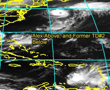
And our super speed depression down in the Caribbean has fallen apart, and is now in the eastern Caribbean "Hurricane Graveyard". The forward speed of the depression was too great, and its so enlongated and disorganized, i don't see any chance of a recovery for it as it stands now. Persistance is the key, and it has stayed persistantly disorganized. The remains will be something to look at for a while though. My bet, nothing comes of it.
General Links
Current Aircraft Recon Info
NRL Monterey Marine Meteorology Division Forecast Track of Active Systems (Good Forecast Track Graphic and Satellite Photos)
Check the Storm Forum from time to time for comments on any new developing system.
Follow worldwide SST evolution here:
Global SST Animation
NASA GHCC Interactive Satellite images at:
North Atlantic Visible (Daytime Only), Infrared, Water Vapor
LSU Sat images
Some forecast models:
NGM, AVN, MRF, ETA ECMWF
AVN, CMC, GFDL, JMA, NOGAPS, UKMET
DoD Weather Models (NOGAPS, AVN, MRF)
Multi-model plots from WREL
Other commentary at Independentwx.com, Robert Lightbown/Crown Weather Tropical Update Accuweather's Joe Bastardi (now subcriber only unfortunately), Hurricane Alley North Atlantic Page, Cyclomax (Rich B.), Hurricane City , mpittweather , Gary Gray's Millennium Weather, storm2k, Barometer Bob's Hurricane Hollow, Snonut,
Even more on the links page.
| Cycloneye |
| (Storm Tracker) |
| Thu Aug 05 2004 12:13 AM |
|
|
Well Alex is in it's final life as a hurricane then TD#2 fell apart but now a new system will be the most talked in comming days as ALL global models agree on developing it.
TROPICAL WAVE INTRODUCED OVER THE E ATLC W OF DAKAR NEAR 20W S
OF 16N MOVING W 10 KT. YESTERDAY EVENING'S SOUNDING FROM DAKAR
HAD A 55 KT JET CORE AT 600 MB ASSOCIATED WITH THE WAVE... QUITE
A POWERFUL SYSTEM. COMPUTER MODELS ARE HINTING THAT THIS IS A
SYSTEM TO MONITOR WITH A GFS/UKMET/NOGAPS/CMC CONSENSUS
SUGGESTING SOME SORT OF SURFACE LOW WILL DEVELOP IN THE NEXT 36
HOURS ALONG THIS WAVE AXIS. ONLY ITCZ CONVECTION AT PRESENT.
| LI Phil |
| (User) |
| Thu Aug 05 2004 12:47 AM |

|
|
|
Don't forget to check the comedy forum
| cyclone_head |
| (Weather Hobbyist) |
| Thu Aug 05 2004 01:26 AM |

|
|
|
I know...I need to get a life but does it seem there is a flare-up that is actually easterly of what was formerly TD#2? Earlier there seemed to be more dry air surrounding TD2 from all sides but I see a westerly trough closing in and storm activity that developed along the coast of South America.. There is still nothing but dry air to the east but could the center of former TD2 be reforming east of the earlier center as we knew it?
Here is the WVL...
http://www.goes.noaa.gov/HURRLOOPS/huwvloop.html
|
danielw
|
| (Moderator) |
| Thu Aug 05 2004 01:53 AM |

|
|
|
I'm not convinced TD2 is falling apart. The SAT loops all show a CDO like structure on the Southern side of the storm. In the last hour all the lightning has shifted to this area, which is located just N of Bonaire. I'm not a Met., but if the convection on the western side is set up just right won't it block some of the shear? Think NHC may have to rethink the recon for tomorrow. Like sunrise maybe! Waiting and watching.
note:As of 0200Z there appears to be a NW wind component shaping up on the SW side. Could the circ. be closing??
| recmod |
| (Weather Guru) |
| Thu Aug 05 2004 01:54 AM |

|
|
|
NRL now lists Alex at 105 knots with a central pressure of 957 mb
--Lou
| LI Phil |
| (User) |
| Thu Aug 05 2004 01:58 AM |
|
|
|
|
WOW!
Just updated the 2004 "so far" numbers
| jth |
| (Storm Tracker) |
| Thu Aug 05 2004 02:02 AM |
|
|
That flare up is exactly where I thought I saw a LLC earlier. Notice that the forward motion of that area has really slowed. Could be wrong, but I think TD2 is going to make a comeback.
| Unregistered User |
| (Unregistered) |
| Thu Aug 05 2004 02:04 AM |
|
|
If the Wave Formerly Known as TD2 doesn't develop in the Atlantic, I still hold out hope for it to become the first major hurricane of the season in the NEP.
Really, aside from the Carib. wave, I don't see anything on the horizon for a week at least, barring some unusual development for the ragged remnants of the Cape Verde wave.
| BillD |
| (User) |
| Thu Aug 05 2004 02:06 AM |
|
|
I'm not sure that we ever knew where the center was, or even if there really was one. I think TD2 is still with us, there is at least still some mid-level circulation. The fact that it is so close to land to the south is not helping it any.
Bill
| cyclone_head |
| (Weather Hobbyist) |
| Thu Aug 05 2004 02:09 AM |
|
|
|
|
>"Anyone think this is a CAT III?" posted at 4:39 pm by Phil
Was this an accurate forcast Phil? Think so... as it turned out...
|
danielw
|
| (Moderator) |
| Thu Aug 05 2004 02:14 AM |
|
|
|
|
Take a look.
http://www.srh.noaa.gov/radar/latest/DS.p19r0/si.tjua.shtml
| Old Sailor |
| (Storm Tracker) |
| Thu Aug 05 2004 02:16 AM |

|
|
|
TD#2 could reform , but the wind shear is very strong in western Cari. wait and see, with a strong cold(cool) front coming all the way down to Florida, This time of year any cold front that makes it to GOM tends to cause a problem early to mid week 9 to 12th.
Dave
|
danielw
|
| (Moderator) |
| Thu Aug 05 2004 02:49 AM |
|
|
|
|
Nice shot. Look a the size and shape of XTD2 on this WV shot from LSU at 0145Z.
http://antares.csi.lsu.edu/webpics/goes/Storm/Tropics/latest_wv.jpg
| Tropics Guy |
| (Storm Tracker) |
| Thu Aug 05 2004 02:58 AM |

|
|
|
Think that EX-TD#2 is not dead yet, seems to have slowed down, and a nice ball of convection has developed near the center. Shear needs to lessen & it needs to gain a little bit more latitude before we see any significant development, we'll see what it looks like in the AM.
nite, yall

TG
| LI Phil |
| (User) |
| Thu Aug 05 2004 02:59 AM |
|
|
|
|
Quote:
>"Anyone think this is a CAT III?" posted at 4:39 pm by Phil
Was this an accurate forcast Phil? Think so... as it turned out...
Yes, and for once, this was NOT just a crazy, hurricane mongering wishcast. I mean, it was close enough to CAT III status as it was.
Now, if I could just get it right with TD2...
| BillD |
| (User) |
| Thu Aug 05 2004 03:09 AM |
|
|
I'll admit anything could happen at this point. But look at the current WV loop, right now what-was-TD2 is only getting some shear on the leading edge. In fact, it is taking up the entire eastern Caribbean Sea from SA to PR (you can see its effects on PR radar). That is not some wimpy wave that is going to fizzle.
If it does not develop and isn't pulled northward by the trough, then the shear in the western Caribbean will probably tear it up, but I don't think it will ever get that far west.
Bill
| javlin |
| (Weather Master) |
| Thu Aug 05 2004 03:22 AM |
|
|
I saw the WC channel tonite Lyons said Gulfstream was to fly around the system not thru it.They are rethinking the track I believe.He mentioned they wanted to no more about the surronding eviroment.I am not saying this going to happen by no means but Camille made S of Cuba as wave .I mention a few forums ago that it was thought that the unusal cool front had some kind of impact on her development.Just drawing parallels every year and every system is different but the date 8/17 uncanny.Let it go at that just food for thought.
|
danielw
|
| (Moderator) |
| Thu Aug 05 2004 03:41 AM |
|
|
|
|
Javelin, you are certainly correct with reference to Camille.
"Camille was detected by satellite on August 14, 1969, as a tropical disturbance moving west in the Caribbean Sea. Early on the 15th, Camille became a strengthening hurricane while located off the western tip of Cuba.'"
Storm CAMILLE is number 3 of the year 1969
August 14 18 UTC 19.4N 82.0W -- deg -- mph -- kph 60 mph 95 kph 991 mb Tropical Storm
I haven't been able to find the data the Gulfstream found. I have noticed over the last 4 hrs that the western edge of TD2 is round, not jagged and ragged as before. The WV shot I listed above shows an almost complete circle. The exception being S America.
Who was is that said CAT V earlier today?
| HanKFranK |
| (User) |
| Thu Aug 05 2004 03:53 AM |

|
|
|
dude, did you just relate the remnants of a tropical depression to hurricane camille? you might want to rethink the parallels.. cause they're about like relating a little league baseball player to a hall of famer. sure, it's infinitesmally possible, just not credible by any standard.
mjo be damned, we seem to be in an active span. either t.d. 2's remains have made one of the most dramatic slowdowns i've ever seen or this is a trick of IR imagery. i've eyeballed it on IR ch2 and the stuff i was guessing earlier.. that the proximity to land is aiding in causing drag on the south of the system, and that the wave axis is leaning forward as opposed to tailing back to the north like they usually do.. that stuff checks out. but really until the visibles tomorrow come out there won't be any strong clues as to what is going on with the blow up that is now less than 100mi north of isla de margarita (which inspires thoughts of jimmy buffett). they'll probably recon it unless the convection decays overnight (in which case the system would more than likely be beyond recovery). great uncertainty.. tomorrow should decide whether this thing goes away or becomes a bother.
alex is present proof that stuff can happen at high latitudes, and that when a sheared hurricane travels with the flow, it can still crank way up. i don't expect it to get a great deal stronger.. whatever is left of it will probably give the british isles a good shellacking monday-tuesdayish.
92L has a good low level turning and persistent local convection.. and it is not long before it will be over good support waters. i've got an inkling it might be the next depression by saturday, if things continue improving. also, note.. it is not going interminably NW like the models progged it to. is actually on a slightly south of due west trajectory... for the moment. should be near/north of the islands around sunday.
new wave coming off has all kinds of global support, and earlier folks were quoting the discussion mention of an impressive signature as it passed dakar. it's on the short waiting list, models have it developing a surface low near the itcz/35w or so by saturday.
heed what ol' sailor says about what gets left behind in the gulf, or off the eastern seaboard. there will probably be an earlier split of the trough than progged by gfs.. trend is going that way so far.. so look for an area of disturbed weather early/middle next week near the southeastern u.s.
i should get some sleep now. night folks.
HF 0353z05august
| javlin |
| (Weather Master) |
| Thu Aug 05 2004 04:24 AM |
|
|
Love the response there HF someone got to stir the pot(me).I am not making that much of a reference or am I ?Well just wanted to point out stranger things have happened.Not that it will by no means just keep one eye open.Till the wave goes away or it slams into the dirt keep one eye open . See you guys tomorrow time to get back to that Scotch.:-)
|
danielw
|
| (Moderator) |
| Thu Aug 05 2004 04:32 AM |
|
|
|
|
Here's a link for you to determine the quick intensification of Hurricane Camille.
ftp://ftp.nhc.noaa.gov/pub/storm_archives/atlantic/prelimat/atl1969/camille/prelim05.gif
These ESSA 9 satellite pic shows Camille's development over a 5 day period. They are rather low resolution and only the date is shown. I've read some archives somewhere that there was indeed a cold/ cool front moving into MS/ LA from the NW, and it gave the forecasters a bit of a problem.
Some of the forecasters that followed Camille:
Tropical Storm Camille advisory #1 was signed by "Simpson", of the Saffer-Simpson scale.
Advisory #4- signed by Neil Frank- now a Houston Met.
And Advisory#6- signed by the late, great John Hope-WxChan
|
danielw
|
| (Moderator) |
| Thu Aug 05 2004 05:40 AM |
|
|
|
|
WHXX01 KWBC 050212
CHGHUR
DISCLAIMER...NUMERICAL MODELS ARE SUBJECT TO LARGE ERRORS.
PLEASE REFER TO TPC/NHC OFFICIAL FORECASTS FOR TROPICAL CYCLONES.
NATIONAL HURRICANE CENTER NORTH ATLANTIC OBJECTIVE AIDS FOR
TROPICAL DEPRESSION TWO (AL022004) ON 20040805 0000 UTC
...00 HRS... ...12 HRS... ...24 HRS... ...36 HRS...
040805 0000 040805 1200 040806 0000 040806 1200
LAT LON LAT LON LAT LON LAT LON
BAMD 13.6N 65.0W 14.5N 67.5W 15.4N 69.6W 16.3N 71.5W
BAMM 13.6N 65.0W 14.5N 68.3W 15.5N 71.1W 16.4N 73.6W
A98E 13.6N 65.0W 14.1N 67.8W 14.9N 70.4W 15.8N 72.5W
...48 HRS... ...72 HRS... ...96 HRS... ..120 HRS...
040807 0000 040808 0000 040809 0000 040810 0000
LAT LON LAT LON LAT LON LAT LON
BAMD 16.9N 73.3W 18.2N 78.1W 19.5N 83.8W 20.2N 89.7W
BAMM 17.5N 75.6W 19.9N 79.1W 22.4N 82.7W 24.2N 85.4W
A98E 16.6N 74.4W 18.8N 78.1W 21.3N 81.8W 24.2N 85.4W
...INITIAL CONDITIONS...
LATCUR = 13.6N LONCUR = 65.0W DIRCUR = 275DEG SPDCUR = 15KT
LATM12 = 13.6N LONM12 = 61.6W DIRM12 = 269DEG SPDM12 = 19KT
LATM24 = 13.5N LONM24 = 57.4W
WNDCUR = 30KT RMAXWD = 40NM WNDM12 = 30KT
CENPRS = 1011MB OUTPRS = 1013MB OUTRAD = 75NM SDEPTH = M
RD34NE = 0NM RD34SE = 0NM RD34SW = 0NM RD34NW = 0NM
http://www.srh.noaa.gov/data/WBC/CHGHUR.0408050216
| javlin |
| (Weather Master) |
| Thu Aug 05 2004 05:42 AM |
|
|
I looked at it to HF this system put the skids on.I would normally think change in movement is about to occur.Dam never seen one stop that quick.
|
danielw
|
| (Moderator) |
| Thu Aug 05 2004 07:33 AM |
|
|
|
|
If you look a few posts back I listed the 00Z model plots for XTD2.
I used A98E points for the track, endpoint was A98E and BAMM, as the fcst had them at the same endpoint, at 8/10 00Z.
From present position, to over Kingston, Jamaica-08/08 00Z; then over the Isle of Youth, Cuba-08/09 06Z; then to a point due west of Key West/ mid Yucatan Channel.
This point is exactly 1.1deg east of where Camille was plotted on 8/16/1969 at 18Z.
Let's just hope the rest of the similarities Do Not present themselves.
http://environmentalphilosophy.org/homepages/roger_pielke/camille/figures/fig1b.gif
The 8/10/04 1000Z endpoint is 400 miles SE of the Mouth of the MS River
| James88 |
| (Weather Master) |
| Thu Aug 05 2004 09:01 AM |

|
|
|
Alex remains a 120mph hurricane for the second advisory in a row. It still boasts a very well defined eye that is embedded in cold cloud tops. In fact, the clouds have cooled somewhat over the past few hours. A very interesting (and record breaking) hurricane to kick off the season.
|
danielw
|
| (Moderator) |
| Thu Aug 05 2004 09:35 AM |
|
|
|
|
A small low level circulation and some sporadic convection is all that appears to be left of XTD2. There are some low clouds visible on IR and WV imagery, but the intrusion of the trough? into the apex of the leading edge, quickly killed the earlier round, full shape of TD2. The ridge to the north appears to have broken down also.
0934Z
| h2ocean |
| (Weather Hobbyist) |
| Thu Aug 05 2004 11:22 AM |

|
|
|
Bastardi is still concerned it may redevelop and several of the models redevelop it...but who knows with this one!
Interesting excerpt from the Melbourne NWS this morning...
OTHER CONCERN FOR THE WKND IS THE REMAIN OF TD 2 WHICH 00Z GFS
DEVELOPS AND MOVES NORTH ACROSS CUBA AND CLOSE TO THE AREA LATE SUN
NGT AND MONDAY PASSING BY JUST TO OUR EAST. SINCE THIS IS THE FIRST
GFS RUN THAT HAS FORECAST THIS SOLUTION HAVE TRENDED FORECAST POPS
AND CLOUDINESS A BIT MORE PESSIMISTIC FOR EARLY IN THE WEEK AND KEPT
RAIN CHANCES GENERALLY IN THE SCATTERED RANGE.
| Unregistered User |
| (Unregistered) |
| Thu Aug 05 2004 11:44 AM |
|
|
hhhmmmm. Need the shear to abate some....and it should after 24 hours. Waiting in Palm Bay! Umm, yes a couple of the globals show this in various forms. Most notably the GFS, but also the NOGAPS and the UK. Cheers!! PS: So we may not be done with TD #2 (former) to come back to life. In that scenario, it would have to come north with the return flow of the washed out front over Okeechobee!
| Unregistered User |
| (Unregistered) |
| Thu Aug 05 2004 01:34 PM |
|
|
XTD2 is in the same kind of wind flow that killed off 97L for the final time that evening. I do not think regeneration is likely.
Alex became a Cat III last night, and still is. This, I am sure, caught everyone off guard. When this formed, I'm sure everyone would have laughed if anyone posted that Alex would eventually become a hurricane, especially a major hurricane
92L is getting better organized and is in much more favorable winds than former TD was, and 92L may become TD3 within 24 hours.
| andy1tom |
| (Storm Tracker) |
| Thu Aug 05 2004 01:36 PM |

|
|
|
looks like they are covering all the bases just in case
AN AIR FORCE RESERVE
HURRICANE HUNTER AIRCRAFT IS SCHEDULED TO INVESTIGATE THE SYSTEM
THIS AFTERNOON...IF NECESSARY.
| Rabbit |
| (Weather Master) |
| Thu Aug 05 2004 01:45 PM |

|
|
|
they are still not going to find an LLC
| rickonboat |
| (Weather Hobbyist) |
| Thu Aug 05 2004 01:55 PM |
|
|
Climatalogically speaking, if a wave were to survive the graveyard in the Carribean, and somehow manage to get in the GOM, then we all know the HOT month of August is priime time for rapid intensification. It may be an anomaly if TD#2 survives, nevertheless, a real possibility, which in and of itself renders a rare strong hurricane to develop. My inward thoughts, anyway...
| andy1tom |
| (Storm Tracker) |
| Thu Aug 05 2004 01:59 PM |
|
|
|
|
they probably won't this afternoon but if it stays going and doesn't fall apart?. i think that the unpredicatable alex may have pushed the buttons on the nhc..and they are not falling for it the second time.
| ErinAndOpal95 |
| (Verified CFHC User) |
| Thu Aug 05 2004 02:44 PM |
|
|
TD#2 looks pretty impressive to me. Check out the IR south of Hait/Dominican Republic.
| Rabbit |
| (Weather Master) |
| Thu Aug 05 2004 02:49 PM |
|
|
|
|
Alex still at 120mph
as for the former depression, if you look at the visible image, you will likely not be able to find any rotation (I'm still hoping I was wrong on this one though)
Alex
| Steve |
| (Senior Storm Chaser) |
| Thu Aug 05 2004 03:00 PM |

|
|
|
I had some thoughts on XTD2 when I first looked at it this morning. It reminded me a bit of 90L which I think was the wave that slowed down, split, helped spawn the rogue storm off the east coast and then continued on across the southern Gulf into Mexico. The difference was that the trof split was already in front of this particular system instead of meeting it halfway. Hostile conditions await, but if it can bust that trof split, the southern axis of the wave may well get a chance to crank near where >I< have it progged in Hank Frank's contest. What we're seeing today appears to be divergence based on the wave interacting with the eastern boundary of the trof. We're also seeing the wave split with some of the energy heading off NW while the southern energy progresses westward (albeit at its slowest rate so far). I think the Eastern Gulf may have to watch this one, and I'm sure all you guys down there will keep your eyes on it for the next several days.
Went and read Bastardi to get his comments while composing this post. He offered a couple of interesting ideas concerning implications for Alex and Europe (based on warm water - heh, where have we heard that before???). He also thinks that if anything is in the NW Caribbean by Sunday, it's going to have to be watched. Doesn't like GFS's SE FL scenario, notes ECMWF is farther west and UKMET allows for even a more westerly drift. Basically with all the amplitude in the westerlies, the map should be ripe to conjur up some action. We'll see.
Steve
| James88 |
| (Weather Master) |
| Thu Aug 05 2004 03:14 PM |
|
|
|
|
Needless to say, any wave that makes it into the Gulf intact needs to be very closely monitored.
BTW, anyone noticed that a couple of models - BAMM and BAMD - take Alex and recurve him south back into warmer waters. An unlikely situation perhaps, but wouldn't it be the icing on the cake if Alex once again surprised everyone and did something completely unexpected (again).

| Rabbit |
| (Weather Master) |
| Thu Aug 05 2004 03:22 PM |
|
|
|
|
interesting to think that the 120 mph hurricane we have now was forecast only to 45 mph, and at the beginning, looked like it may not even reach storm strenght
| Rabbit |
| (Weather Master) |
| Thu Aug 05 2004 03:25 PM |
|
|
|
|
note: I've added two sections to the forecast:
a "so far" as someone else has (I think Phil)
I've also added a "depression" forecast, so #/#/#/#=TD/TS/H/MH
| ErinAndOpal95 |
| (Verified CFHC User) |
| Thu Aug 05 2004 03:26 PM |
|
|
Check out this visible of TD#2. Nice and round with deep cloud convection. It will likely be ripped apart by the front, i guess. or not?
http://www.nrlmry.navy.mil/tc_pages/04_ATL_91L.INVEST_ssmi_vis1km_full.html
| Rabbit |
| (Weather Master) |
| Thu Aug 05 2004 03:31 PM |
|
|
|
|
16N South of Dominican Republic
could that be the beginnings of an LLC??
also, 92L on TWO:
A SMALL LOW PRESSURE SYSTEM IS LOCATED ABOUT 1300 MILES EAST OF THE
NORTHERN LEEWARD ISLANDS. ALTHOUGH THE SYSTEM SHOWS SIGNS OF
ORGANIZATION...SHOWER ACTIVITY REMAINS LIMITED AT THIS TIME. THIS
SYSTEM HAS THE POTENTIAL TO BECOME A TROPICAL DEPRESSION DURING THE
NEXT DAY OR TWO AS IT MOVES WESTWARD AT ABOUT 15 MPH.
| ErinAndOpal95 |
| (Verified CFHC User) |
| Thu Aug 05 2004 03:42 PM |
|
|
"16N South of Dominican Republic
could that be the beginnings of an LLC?? "
There does appear to be some spin just off the NW edge of the mass of clouds for TD#2 at 16N.
| LI Phil |
| (User) |
| Thu Aug 05 2004 03:43 PM |
| Attachment |
|
|
|
|
XTD2 (91L) still up on the NRL site, so they must feel there is something worth watching. Somewhat tongue in cheek, I took HF's challenge (see storm forum) for TD2, and offered a couple of options, the last of which I took, which was that TD2 would miss the trof and slide into the Gulf as a CAT V heading for rickonboat. Well, I really don't think that's going to happen (and I sure pray it doesn't), but that scenario could actually play out (getting into the GOM). Obviously it's still way to early to speculate on future Gulf activity, but, like Steve, I'm concerned about something getting going east of NO, anywhere from LA/MS border to the big bend.
92L seems to also have come back from the "dead". This is probably going to be TD3, maybe sometime within the next 24 hours. Haven't really done any research on it yet, so I'm just throwing the possibility out there (as others already have).
Today is a real watch and wait day. Stay tuned.
As for Alex, yes James, I did see the BAMs taking him back into the east Atl. Somehow, I do not believe that is climatologically possible, given that it would be an extratropical low and being carried with the steering currents, but that'd be something, huh? (click on the attachment at top of this post for the models)
| summercyclone |
| (Weather Hobbyist) |
| Thu Aug 05 2004 04:00 PM |

|
|
|
No circulation on 91L unless it is under the deep convection (where it should be); does seem to be going more wnw to NW, it may clip Haiti on current course. Strong possibility of regeneration, depending to some degree on future course.
92L---it looks like a depression already, although small and lacking convection. If the environment will leave it alone, it will be upgraded to depression status at the earliest by 5pm, and latest tomorrow morning.
Alex being a major should amplify the ridge, 92L will likely go more west than previously predicted; 91L also.
Alex turn southward?...it has happened before!! Especially if the ridge amplifies (it is on top of the ridge, remember!)
sc

Watch the Gulf this weekend too..
ps---El Nino is on the way back...see these links:
http://www.nhc.noaa.gov/gifs/pac_anom.gif
http://www.cpc.ncep.noaa.gov/products/analysis_monitoring/enso_advisory/index.html
What will this do to this season?...hmm...possible truncate it...but, El Nino years where it develops late or partially, sometimes produce strong bursts of activity in Aug and September, but after that it trails off quickly. So---we have 1.5 good months for sure it seems.....
Could be quiet in October and Nov due to this.....may also account for the 'struggling nature' of storms we have seen so far---however, they can overcome the struggle ala Alex--especially at higher latitudes. New England and Maritimes--watch out!
| Unregistered User |
| (Unregistered) |
| Thu Aug 05 2004 04:34 PM |
|
|
http://www.ssd.noaa.gov/PS/TROP/DATA/RT/watl-vis-loop.html
Possible Circulation???
How bout that ALEX !!!! WOW what a sleeper. We weren't sure if it was going to be a Hurricane, now look at it.
Steeming off at 35mph still touting winds sustained at just about 120mph.
"MAXIMUM SUSTAINED WINDS ARE NEAR 120 MPH...195 KM/HR...WITH HIGHER
GUSTS."
Just incredible...

| Unregistered User |
| (Unregistered) |
| Thu Aug 05 2004 04:53 PM |
|
|
Too hard to tell under that cloud of divergence. If you look at the Dvorak loop, appears shear is shooting a firehose at the wave from the west. Allso NE'erly shear at 45 degrees to the west shear across Cuba. If this disturbance wants to re-generate, it needs to gain some latitude (Jamaica). Shear is SUPPOSED to decrease during the next day or so. 12Z GFDL sparks it up again and moves it further west, but still hooks it out to sea (bad solution). We wait and watch. Cheers.
| Unregistered User |
| (Unregistered) |
| Thu Aug 05 2004 05:16 PM |
|
|
HI.
Well, well..how many of us were caught off guard by recent developments? Did anyone here ever imagine seeing Alex explode and strengthen into such a beautiful intense mesmerizing storm? Blew me away. Blows me away?
Shows you how you can never be sure of anything, especially in the tropics.
Saw him yesterday when that stadium effect was starting and thought to myself quietly.. very quietly (in awe) he's going to hit Cat 3. A major. First storm of the year... heads over land and becomes a major moving towards a low hit on Europe. Stunning.
As for TD2..Bonnie girl wanna be... giving her enough rope to play a bit and see where she will go. How things play out. For once not predicting or wishing or figuring or anything, just let the girl play.. see what she can or can't do. That is the song right? Girls just want to have funnnn...Well, seems the wave that was formerly known as the B storm that might become the B storm is playing around, doing her thing and all we can do is watch and wait to see if she has a date with a real name.
Great posts.. took a break a bit and catching up and smiling.
Who knew? Major Cane indeed.
ps... what did Rabbi predict from Alex? Don't want to go back into all those posts but curious.
Bobbi
ps...agree quietly on el nino tho think he will wait to hit his peak around Christmas Time, decorate the whole Ocean in his favorite color as El Nino should officially do. Maybe no big November storms but what an August surprise.. better than July.
| Rabbit |
| (Weather Master) |
| Thu Aug 05 2004 05:31 PM |
|
|
|
|
"Rabbit" not "Rabbi"
I forcasted Alex would reach hurricane, but not much farther. There was speculation from several people (including myself) as to whether or not it would reach major hurricane.
as for the former depression, I still dont think it will regenerate before reaching the western Caribbean
| javlin |
| (Weather Master) |
| Thu Aug 05 2004 06:23 PM |
|
|
I do not no the site for the T# but was over at S2K it was brought up that both 91L and 92L are at 1.5/1.5.Can anyone year verifiy that.
| James88 |
| (Weather Master) |
| Thu Aug 05 2004 06:24 PM |
|
|
|
|
The T-numbers for 92L and XTD #2 are up to 1.5/1.5. Perhaps this shows a little potential for development.
| javlin |
| (Weather Master) |
| Thu Aug 05 2004 06:28 PM |
|
|
James what is the site?
| andy1tom |
| (Storm Tracker) |
| Thu Aug 05 2004 06:37 PM |
|
|
|
|
they are listed here. don't know how up to date though, always have a hard converting times
also noticed that we have 47 users.. things are heatin up
#'s
| Rabbit |
| (Weather Master) |
| Thu Aug 05 2004 06:42 PM |
|
|
|
|
91L is showing outflow boundaries
in respect to tropical systems, this means the air is flowing outward, not inward, indicating that there will be no development. I expect the convection to die down again tonight, and flare back up tomorrow with the afternoon heating and upper air divergence.
91L
as for 92L, which has a well-defined rotation and LLC, it may be upgraded at 5pm.
92L
Alex
| javlin |
| (Weather Master) |
| Thu Aug 05 2004 06:46 PM |
|
|
Thanks Andy appreciate it.
| andy1tom |
| (Storm Tracker) |
| Thu Aug 05 2004 06:53 PM |
|
|
|
|
Javlin here is another good site to see what is going on in the carb.. it loads slow but is worth the wait. current weather
| Unregistered User |
| (Unregistered) |
| Thu Aug 05 2004 06:54 PM |
|
|
i seem to have a really BIG problem lately with the T thing
first was outter and now its dropping them
where is my mind, giggling
sorry
great comment on outflow and inflow boundaries, never heard that put so well btw.. will always remember it
rabbit
rabbit
really i knew that
fingers were tired.. at work..
| Unregistered User |
| (Unregistered) |
| Thu Aug 05 2004 06:57 PM |
|
|
Can someone explain the difference between when wxr ppl say "good inflow" and or "good outflow" and outflow boundaries that aren't good, please
thanks
| Rabbit |
| (Weather Master) |
| Thu Aug 05 2004 06:59 PM |
|
|
|
|
good inflow=low level convergence and circulation
good outflow=upper level divergence
outflow boundary=cool dry air racing away from collapsing thunderstorms
| javlin |
| (Weather Master) |
| Thu Aug 05 2004 07:05 PM |
|
|
Yea i had that one Andy decided to go look at it.Aruba is the only location with any pressure falls down to 1008.The system is really quite remove Aruba don't know why that may be.I went and looked at WV loop of the Atl. then I saw why that maybe.
| Unregistered User |
| (Unregistered) |
| Thu Aug 05 2004 07:09 PM |
|
|
thanks, perfect
| summercyclone |
| (Weather Hobbyist) |
| Thu Aug 05 2004 07:09 PM |
|
|
|
|
Yeah, see those lines of cloud, cloud arcs actually, out in front of the tropical wave---rope clouds. Bad sign, indicates collapsing convection...and shear is blowing the tops off.....this sure doesn't look like August, it is an el Nino related effect....
little cluster off Fl, has the same look, rope clouds expanding toward the west.
92L is stretching out a little, but also building convection..shear evident there too.....
If the shear doesn't lay off, it'll be mid and high latitude storms only, which is a n el Nino signature too.....
sc
| summercyclone |
| (Weather Hobbyist) |
| Thu Aug 05 2004 07:12 PM |
|
|
|
|
Heat is why there pressure is so low--and the wave axis nearby, gets very hot there.
sc
| Unregistered User |
| (Unregistered) |
| Thu Aug 05 2004 07:19 PM |
|
|
Someone cries El Nino around here and every one suddenly comes out of the water screaming SHARK!!!
Do think El Nino is starting. Not sure that we won't have CV .. think we will.
Personally (and I've said this to a few friends) I think the reason the GULF June/July season could be related to El Nino even though its not apparent yet. Reminded me of 97.. Maybe like pressure drops before winds intensify there are signs out there.
But...wouldn't shut down the door on the season.
Atlantic/CV has a problem (if any) because of dust.. no reason betsy/andrew storms couldn't form.
First place to see signs of El Nino would be closest to its home base.. Carib.. Gulf.
Good explanation on outflow boundaries. Always knew that but knew it instinctually I think.. never had a real crisp explanation.
breathe a bit on the El Nino thing before the powers that be get upset we aren't talking on topic.
and..may I say here.. think we should have an El Nino board for news related articles and observations
thanks, bobbi
| Unregistered User |
| (Unregistered) |
| Thu Aug 05 2004 07:22 PM |
|
|
reason that we didn't have a normal Gulf/BOC/Carib season in June/July was because of a possible El Nino forming.
| Rabbit |
| (Weather Master) |
| Thu Aug 05 2004 07:28 PM |
|
|
|
|
I still think there were two or three storms before August that weren't classified
| Unregistered User |
| (Unregistered) |
| Thu Aug 05 2004 07:33 PM |
|
|
Quote:
I still think there were two or three storms before August that weren't classified
I don't think so . We here the same thing year after year from Joe bastardi .
http://www.hardcoreweather.com
| Robert |
| (Weather Analyst) |
| Thu Aug 05 2004 07:50 PM |

|
|
|
LOL People its only august 5th the verde season does not even realy start till september, The signature in the pacific is the same its been for the past 3 years at this time wich is god only knows id like to call it nuetral. There is a build up of warmer then normal water in the central pacific but there is still a large la nina cold tongue streching out off equadore for a long ways. Granted the SOI is indicating that a possibly weak to moderate el nino is on the way it will not happen till late fall early winter possibly changing the outcome of 2005 but not for 2004 excpect a season much like 2000 - 2003 this year.
| Rabbit |
| (Weather Master) |
| Thu Aug 05 2004 07:51 PM |
|
|
|
|
Subtropical Storm--May 25
Subtropical Storm--Jun 18
possible Tropcial Depression or Tropcial Storm--Jul 9
Tropcial Storm
| Rabbit |
| (Weather Master) |
| Thu Aug 05 2004 08:11 PM |
|
|
|
|
remember that in 1998, the count by August 5 was 1/0/0, and TD2 (which became Bonnie) didn't even form until Aug 19. In the last week, there have been 2 tds, possibly on the way to a third
here are a few recent examples of late starts in active years:
1996: no August storms until Aug 19 (Dolly)
1998: Bonnie formed Aug 20; Total: 14
1999: Bret formed Aug 20; total: 12
2000: Beryl formed Aug 14; Total: 14
2001: Chantal, the first Cape Verde system, formed Aug 15; Total storms: 15
Also, if an El Niño were in existence, the Eastern Pacific would have had more than four storms by now, and would likely not have gone all of June without so much as a depression; last time that happened was 1969, which also had a late start in the Atlantic:
no TD until July 25
the first hurricane, Blanche, was Aug 11, 8 days after this year
the first major hurricane, Camille, was Aug 15, 10 days after this year
I am by no means predicting a season as active as 1969 or another Camille, but the evidence points to an active season, not a quiet one.
| rickonboat |
| (Weather Hobbyist) |
| Thu Aug 05 2004 08:24 PM |
|
|
the wave seems to be holding together all day, quite nicely. Is it starting to take shape? Doesn't appear that the tops are being blown off of it by shearing winds aloft.
I think this has the look of surviving....
Camille wannabeeee?
| Unregistered User |
| (Unregistered) |
| Thu Aug 05 2004 08:26 PM |
|
|
Looks like former TD 2 is going to dissipate...getting shredded by the strong jet in the C Carib...not sure about 92L---could get upgraded at 5, but, if they are being cautious at NHC, not.
sc
Look at what is brroiling over the Canal Zone---high overhead, promoting jet that is shredding Bonnie wannabe.
| Steve |
| (Senior Storm Chaser) |
| Thu Aug 05 2004 08:47 PM |
|
|
|
|
Yeah, but look at the upper air progs. That jet (and the ULL) is moving SW out front of the system. Down the line, it shouldn't have much of an effect. For now, it's just holding the system in check and disallowing recurvature.
------------------------------------------------
As to El Nino, there are mixed signals. Nino 3-4 is definitely in a warm phase. But this is offset by the cold phase in the Eastern Pacific. There are occasional bursts of westerlies down there but it shouldn't have much of an effect (enhancing or supressive) on the bulk of the 2004 season.
Steve
| doug |
| (Weather Analyst) |
| Thu Aug 05 2004 08:55 PM |
|
|
If it does refire the main center is still south of 15N that's where some convection is persisting.
| summercyclone |
| (Weather Hobbyist) |
| Thu Aug 05 2004 09:03 PM |
|
|
|
|
Could have been upgraded at 5, structure has improved, but, still very small, and a bit stretched out. There is some sw and w shear just ahead of it, doesn't look too bad.
Although they could upgrade at 11, I'll say 5am or 11am tomorrow, assuming it holds together, of course!
sc
| PFSThunder |
| (Weather Watcher) |
| Thu Aug 05 2004 09:07 PM |

|
|
|
For all those people worried about lack of storms should remember that TS and hurricanes form to rid the tropics of excess heat and carry this energy to the Northern latitudes. The water temps have been above normal all season so I would guess this translates to an above average season in my eyes.
| Rabbit |
| (Weather Master) |
| Thu Aug 05 2004 09:11 PM |
|
|
|
|
over and done with as far as i am concerned
dissipating
| ErinAndOpal95 |
| (Verified CFHC User) |
| Thu Aug 05 2004 09:17 PM |
|
|
No chance of 91L pushing on through to the Gulf and reforming tomorrow or the next day?
| Unregistered User |
| (Unregistered) |
| Thu Aug 05 2004 09:18 PM |
|
|
td 2 is not over and done with. conditions will become better for it in the next. 24 hr.
| Unregistered User |
| (Unregistered) |
| Thu Aug 05 2004 09:20 PM |
|
|
Could be Rabbit. But it will re-fire again tomorrow, and might just be the energy that could cause something to brew near the fizzled out trough that will stretch from the Bahamas through the GOM this weekend. Gone and done with is the easy answer (high probability). Its the 30% chance I look for
 .
.
| BugsBunny |
| (Weather Watcher) |
| Thu Aug 05 2004 09:27 PM |

|
|
|
little note here: I forgot the "Rabbit" password, so I will be logged in as "BugsBunny" for the time being
| LI Phil |
| (User) |
| Thu Aug 05 2004 09:53 PM |
|
|
|
|
>>> over and done with as far as i am concerned
I've learned my lesson, when Bugs says it's over, it's over.
Watching 92L now.
| Unregistered User |
| (Unregistered) |
| Thu Aug 05 2004 10:16 PM |
|
|
Quote:
over and done with as far as i am concerned
dissipating
Silly rabbit

If it survives thru Friday,I believe a strong tropical system,or maybe even a cat 1 Hurricane will be in the GOM this weekend.
Alabama/MIss could be in for a very wet beginning of next week.
Of course I have no explanation for this,just a gut feeling.
| BugsBunny |
| (Weather Watcher) |
| Thu Aug 05 2004 10:26 PM |
|
|
|
|
from the 5 pm TWO:
WELL-DEFINED LOW PRESSURE SYSTEM IS LOCATED ABOUT 1250 MILES
EAST OF THE NORTHERN LEEWARD ISLANDS. THUNDERSTORM ACTIVITY HAS
INCREASED AND BECOME BETTER ORGANIZED NEAR THE CENTER...AND A
TROPICAL DEPRESSION COULD DEVELOP DURING THE NEXT DAY OR SO AS THE
SYSTEM MOVES WESTWARD AT ABOUT 15 MPH.
| Unregistered User |
| (Unregistered) |
| Thu Aug 05 2004 10:39 PM |
|
|
Rabbit, there's nothing in any of those images to suggest that anyhting out there was tropical, yet alone subtropical. Everything there was either a convection-less swirl or a midlatitude baroclinic system. None of the other available tools - such as the cyclone phase analysis tool - suggest anything tropical, either.
This is the start to the season we're looking at now; no sense in trying to go back and say that it might've happened earlier, because it really didn't.
| jlauderdal |
| (Weather Hobbyist) |
| Thu Aug 05 2004 10:57 PM |

|
|
|
Quote:Quote:
over and done with as far as i am concerned
dissipating
If that turns into a cat 1 i will have rabbit stew for dinner.
Silly rabbit
If it survives thru Friday,I believe a strong tropical system,or maybe even a cat 1 Hurricane will be in the GOM this weekend.
Alabama/MIss could be in for a very wet beginning of next week.
Of course I have no explanation for this,just a gut feeling.
|
danielw
|
| (Moderator) |
| Thu Aug 05 2004 11:22 PM |
|
|
|
|
Hey Bugs,
Wu wascally wabbit. It ain't over til it's over. And past 32 deg N latitude, at any longitude!
Here are a couple of links for further analysis on 91L and 92L.
the unnamed IR and WV on the right side of the page will give you some interesting enhanced imagery from LSU.
http://antares.csi.lsu.edu/index.html
| WXMAN RICHIE |
| (Weather Master) |
| Thu Aug 05 2004 11:36 PM |

|
|
|
Watch the huge complex of storms that is making its way towards the bath tub hot Gulf from Louisiana and Mississippi.
|
danielw
|
| (Moderator) |
| Fri Aug 06 2004 12:11 AM |
|
|
|
|
I thought Hispanola was supposed to be a death trap for tropical systems. Check out you favorite IR loop. Maybe that's only if they have good forward motion. Appears the circ. center has moved just north of the westerly shear line.
| Unregistered User |
| (Unregistered) |
| Fri Aug 06 2004 12:20 AM |
|
|
The pressure is avg on island of Hispanola, I don't see anything except blowing off of thunder storm cloud tops do to wind shear right now
http://weather.noaa.gov/weather/current/MDSD.html
| HanKFranK |
| (User) |
| Fri Aug 06 2004 12:27 AM |
|
|
|
|
rabbit is not the most qualified among us to declare things over. he may be right after all... but i haven't heard the stuttering pig just yet. 91L/td2 does look like caca, outflow boundaries and such properly noted, but it is also refiring a good bit and sliding into the right part of the TUTT (southern extent of which is going to split anyway W) and into a region below a shortwave that should split overhead.. there is plenty of opportunity for upper air evacuation. the evidence of a very sharp wave is vaguer than yesterday (thanks a lot upper SWerlies), as the system is also entering an area of mid-level diffluence (precipice of the atlantic ridge which will be flattened out to the north). the profile of the entire disturbance is yet confused, and i'm not sure which part will continue onward. it hasn't worked yet, but now i'm reckoning the system will try to reorganize in this area of weaker steering and diverging upper air flow near jamaica over the next day or two. if it gets further west without development it's opportunities are more limited, and some of the wave energy will get into the gulf where a log jam related to what the big shortwave leaves will be loitering. the chance of development continues, thus the nhc outlook comments and continuing interest, but it hasn't shown a great deal of initiative thus far.
anyway, 40% on it redeveloping tomorrow near 17/72--either out with the shortwave quick or hang on it's belly like a remora until reaching it's desired release point and coming to annoy us. 40% on it ambling wnw, maintaining and remaining a development threat out to 72 hours, closer to the gulf. 20% that rabbit's incessant declaration that it is dying dead or never was will win the day.
the varmint has been restating the old discussion about early-season stuff as well.. i'd still give props to a transient tropical storm in late may and a depression of likewise nature in late july off the northeast (after all, alex seemed to have done alright out there). i won't go as far as the varmint, or as far as clarkE on the issue... minding that clarkE keeps quiet on most things and only says stuff that is well qualified or important.
glad i gave some props to 92L last night, cause it is looking like it will be doing some developing. i'm expecting it to struggle up to a weak tropical cyclone status (depression or just above) and work westward to wnw over the next 48 hours or so. maybe late in the weekend it will start really developing... somewhere near the islands. there should be solid mid-level ridging keeping it on a mostly westward track, but hard to say much beyond that. shear is a variable that could keep it from developing or keep it slow-growing.. but you know which side of the issue i'm on.
new wave coming off, with weaker-than-earlier (of course) model support but presumably fair chances of doing something if that low develops just off the itcz in the next couple of days. keep-in-mind, nothing more as of now.
alex departing after a thankfully mostly offshore performance.
heard the el nino chorus earlier today, will add my voice: *WHAT STEVE SAYS*.
i'm going to ride td2/91L until there's absolutely no chance left.. come crow what may. 92L i like and am fairly confident on. how quickly the sharp trough descending into the east hands control back to the ridge will be a very telling thing to watch.. the chance exists for it to be one of those late-summer/falls where the east coast is in a perpetual trough and activity stays out where we can watch it from a safe distance. i'm head-scratching over that one.
HF 0027z06august
| BillD |
| (User) |
| Fri Aug 06 2004 12:32 AM |
|
|
This is not a dramatic change, but it is a pressure drop:
MDPP obs
Looking at the bigger picture, this is more than a blob of thunderstorms. Whether it will do anything after it moves off of Hispanola overnight is a big question at this point. I think it will, and I can't believe that Phil gave in to Rabbit already!

Bill
| LI Phil |
| (User) |
| Fri Aug 06 2004 12:40 AM |
|
|
|
|
Great post HF (have I ever told you that before?)
>>> I can't believe that Phil gave in to Rabbit already!
Heh.
No, that was a bit of reverse psychology. The varmint's made me to look the fool twice now, so I figure if I agree with him (I'll be wrong -- but so will he). I like his idea of adding the season to date numbers under his prediction...never would have thought of that.
It's still duck season...and they're sittin' on the pond...91L will rise from the ashes, get it's bad self in the gom and head straight for rick as a...
I'm with HF here, I think Bonnie's coming out of XTD2/91L, although 92L could push that back to Chuck.
Like I said in the morning, today is a wait and see day. Tomorrow will tell some tales.
| Unregistered User |
| (Unregistered) |
| Fri Aug 06 2004 12:53 AM |
|
|
Sure you have a pressure drop , but just look at FT Myers same pressure reading, to me that is avg within a thunder storm area.
|
danielw
|
| (Moderator) |
| Fri Aug 06 2004 01:08 AM |
|
|
|
|
Here's the link for the sat shot. the lower clouds (blue) are expanding westward. the lowest clouds (greywhite) are also expanding slowly west.
http://weather.msfc.nasa.gov/GOES/goeseastconusir.html
Use the animation button, and click on Hispanola.
note:0150Z tropical update from TWC. Jim Cantore says the roll type cloud out west of Hispanola is usually "the kiss of death" for these systems. Ok Rabbit!
|
Ed Dunham
|
| (Former Meteorologist & CFHC Forum Moderator (Ed Passed Away on May 14, 2017)) |
| Fri Aug 06 2004 02:26 AM |
|
|
Just some guidance.
1. For what must be at least the third time, Main Page responses on MJO, El Nino, etc., are perfectly fine since they normally are associated with current activity, a lack of current activity, or an anticipated activity. I've made them myself, e.g., from July 19th:
"Regarding El Nino having an impact on this season...well, not very likely. We may eventually get to a weak El Nino state, but it will not happen until the season is over - perhaps in the December-January timeframe - and thats not certain either. The ENSO pattern so far this year is pretty close to the patterns that were observed in 1953 and 1990 - and to a lesser extent to 1969 (1969 was a tad warmer). The oceans are very conservative, i.e., it takes a long time for change to take place. Its probably smarter to look at month to month (or even season to season) changes in SSTs rather than week to week changes when you are trying to determine a trend."
2. The word 'never' is a dangerous word in the Weather business, especially when 'never' becomes 'oops'.
3. Don't make a post with only a statement saying that something will or will not happen without explaining 'why'. They are posts that are nothing more than useless clutter and are often made with the intent of prodding someone else into making an angry response. If I post a statement that Invest 92L will become a TD in two days and will rapidly intensify to hurricane status in four days...and never say anything else, i.e., what prompted me to feel that way, you would be all over my case. HankFrank and I don't care too much for these types of posts, especially those that are intended to aggrevate, so please don't make them. Their survival rate on the Board could become shorter than TD2.
4. There were some good meteorological posts today. There were also some bad meteorological posts today - sometimes by the same individual?!? Thanks for the good ones!
5. Remember that conflicting opinions are often the source for great dialogue. These conflicts are fine as long as you can keep an open mind and respect the other persons point of view - even when you disagree with it.
Cheers,
ED
| javlin |
| (Weather Master) |
| Fri Aug 06 2004 02:46 AM |
|
|
I see what he means on the WV loop it's huge looks like a large ULL ready to eat.Seeya
| LoisCane |
| (Veteran Storm Chaser) |
| Fri Aug 06 2004 03:16 AM |

|
|
|
Had a really long day and company from out of town, a birthday for one of the kids.. it was nice to relax at the end of the day and read through the posts like some round the campfire tropical talk. Great posts. Funny and many accurate thougths.
As for Rabbit. Well.. ok so Phil was playing possum. Thought he gave up. As for being burned twice..well think thats in the eye of the person holding the hot potato. Will see how it all plays out.
You're all funny, smart and fun to read.
As for TD2.. think it followed that trick of the other wave that morphed its way across Haiti... trick of the season, pull that rabbit out of the hat again.
We have so much moisture hanging around Miami .. water logged for sure.
Take care and remember...follow the rules!
Bobbi
like a girl scout...
| LoisCane |
| (Veteran Storm Chaser) |
| Fri Aug 06 2004 03:37 AM |
|
|
|
|
ill say a prayer at bedtime for your girl to show what shes got. so far..she looks exhausted..but those are high mtns in Haiti..
just think..she made the turn afterall lol
models were right about something
|
danielw
|
| (Moderator) |
| Fri Aug 06 2004 05:52 AM |
|
|
|
|
FZNT25 KNHC 060302
OFFN04
NAVTEX MARINE FORECAST
NWS TPC/NATIONAL HURRICANE CENTER MIAMI FL
1130 PM EDT THU AUG 05 2004
SYNOPSIS FOR CARIBBEAN SEA AND TROPICAL N ATLC
FROM 7N TO 22N BETWEEN 55W AND 65W
.SYNOPSIS...TROPICAL WAVE ALONG 73W IS MOVING W 15 KT. THE WAVE
COULD DEVELOPED INTO A TROPICAL CYCLONE. THE WAVE WILL BE NEAR
76W FRI AFTERNOON...NEAR 78W FRI NIGHT...80W SAT...84W
SUN...AND W OF AREA MON. A NEW WAVE WILL MOVE INTO THE
TROPICAL ATLANTIC SAT NIGHT AND NEAR THE E CARIBBEAN MON AND
TUE.
TROPICAL WEATHER DISCUSSION
NWS TPC/NATIONAL HURRICANE CENTER MIAMI FL
205 AM EDT FRI 06 AUG 2004NORTHWESTERN VENEZUELA. UPPER-LEVEL WINDS REMAIN UNFAVORABLE...
BUT MAY BECOME A LITTLE MORE FAVORABLE FOR REGENERATION TO OCCUR
DURING THE NEXT DAY OR TWO. THE SYSTEM IS EXPECTED TO MOVE TO
THE WEST-NORTHWEST AT 10 TO 15 MPH AND BRING LOCALLY HEAVY
RAINFALL TO PARTS OF HISPANIOLA...EASTERN CUBA AND EASTERN
JAMAICA. AN AIR FORCE RESERVE RECONNAISSANCE AIRCRAFT IS
SCHEDULED TO INVESTIGATE THE SYSTEM FRIDAY AFTERNOON...
IF NECESSARY.
THE 1013 MB LOW NEAR 17.5N 43.5W IN THE CENTRAL ATLANTIC NOW IS
A CANDIDATE FOR POSSIBLE TROPICAL CYCLONE FORMATION DURING THE
NEXT 36 HOURS. THIS LOW CENTER IS PART OF A TROPICAL WAVE ALONG
43W/44W SOUTH OF 25N MOVING WEST 15 KT. SCATTERED STRONG
THUNDERSTORMS ARE AN HALF-CIRCLE SHAPE...FROM 9N TO 11N BETWEEN
30W AND 35W. MOST OF THE MIDDLE TO UPPER LEVEL AREA SOUTH OF 20N
BETWEEN 40W AND 60W HAS DRY AIR.
|
danielw
|
| (Moderator) |
| Fri Aug 06 2004 06:55 AM |
|
|
|
|
Yet another satellite shot, new source. Shot includes just about everything in the N Atlantic. Notice the new Tropical Wave on the far right side.
http://meso912.gsfc.nasa.gov/goeseast/tropics/color/0408060615G12.jpg
Here is the main page for the shot. Scroll to the bottom for the most recent shot.
http://meso912.gsfc.nasa.gov/goeseast/tropics/color/
| Rich B |
| (British Meteorologist) |
| Fri Aug 06 2004 10:21 AM |
|
|
With Alex weakening and becoming extratropical it looks set to impact the UK's weather late this weekend and into next week. Our Meteorological Office has issued the following advance warning of severe weather:
THE MET OFFICE IS FORECASTING A DEEP DEPRESSION TO BECOME
ESTABLISHED WEST OF IRELAND OVER THE WEEKEND BRINGING PERIODS OF
HEAVY RAIN AND STRONG WINDS TO NORTHERN IRELAND, WALES AND SOUTHWEST
ENGLAND LATER ON SUNDAY EXTENDING TO SOUTHWEST SCOTLAND AND
NORTHWEST ENGLAND BY MONDAY. DURING MONDAY AND TUESDAY THE RAIN IS
EXPECTED TO BECOME INCREASINGLY THUNDERY WITH SOME VIOLENT
THUNDERSTORMS AND VERY HEAVY DOWNPOURS AS IT PROGRESSES EASTWARDS
ACROSS THE COUNTRY, WHILE DRIER BUT SHOWERY WEATHER FOLLOWS FROM THE
WEST. RAINFALL ACCUMULATIONS THROUGH THE PERIOD ARE LIKELY TO
EXCEED 50MM IN MANY PLACES. LOCALISED FLOODING IS LIKELY.
If you want to keep track of the latest UK Watches or Warnings as ex-Alex threatens the you can visit the UK Met Office site.
Regards
| Cycloneye |
| (Storm Tracker) |
| Fri Aug 06 2004 10:24 AM |
|
|
But when the wet phase of MJO arrives by mid to late august then things wil really heat up.
Dr Gray has made his august outlook and if you want to see why he downgrades the numbers a tad go to storm forum where it is posted.
| Unregistered User |
| (Unregistered) |
| Fri Aug 06 2004 11:41 AM |
|
|
Keep an eye on 92L. I believe its our next td already, and should stay on a westward course for the foreseeable future due to ridging that should be strengthening as the east coast trough lifts out. Cheers!!
| rickonboat |
| (Weather Hobbyist) |
| Fri Aug 06 2004 12:42 PM |
|
|
"If I post a statement that Invest 92L will become a TD in two days and will rapidly intensify to hurricane status in four days...and never say anything else, i.e., what prompted me to feel that way, you would be all over my case. HankFrank and I don't care too much for these types of posts, especially those that are intended to aggrevate, so please don't make them. Their survival rate on the Board could become shorter than TD2.
4. There were some good meteorological posts today. There were also some bad meteorological posts today - sometimes by the same individual?!? "
I had no idea this would turn into a big brother is watching forum. If someone wants to give a gut feel, and doesn't have the meteorological knowledge to back it up...what of it?...shall we limit this to the wordy and "intelligent" moderators and weather watchers, and leave the novices out, like unwanted peasants?...
don't quite understand the point of moderating someone's feeling. This will quickly turn into just a few person's viewpoints, and thereby lose my interest altogether.
| Unregistered User |
| (Unregistered) |
| Fri Aug 06 2004 12:53 PM |
|
|
What is the address to this website? Everyone keeps referring to it, but I haven't found it.
| ticka1 |
| (Weather Hobbyist) |
| Fri Aug 06 2004 01:07 PM |
|
|
I agree Steve. Satellite pictures of 92L are looking better and better. You say its going to stay on a westerly course? At least we will have something to watch this weekend.
| Unregistered User |
| (Unregistered) |
| Fri Aug 06 2004 01:19 PM |
|
|
Well, here, here and bully! I've been posting on this board since '96, and my gut often can be intuitive
and sometimes not!
| Unregistered User |
| (Unregistered) |
| Fri Aug 06 2004 01:23 PM |
|
|
Wow.. you took the words off my fingers that I was going to type and then thought, "why bother?" and didn't bother.
But, you did. And, prefer this comment does not get deleted as I do not want to have to send email to Rick as this is for the whole forum.
Sometimes we DO have a "gut" feeling and that is different from some kid signing on and saying "DUDE, THIS IS GONNA BE A MONSTER GOING TO JAX" I mean there are guidelines and suggestions and then there are enough rules to need a manual.
I'm really sorry but sometimes I get a gut feeling. And, I do have a really extensive background in meteorology and oceanography beyond the casual observer. I am sure my "gut" feeling is based on something I know or learned somewhere but sometimes I don't want to have to sit there trying to put it into proper meteorological jargon that will make some retired met on this board feel he is not wasting his time with 'stupid idiots" and that is the feeling some of us get at times.
This board should be a board for all of us. Those who are working in the field, those who are retiring, retired or aspire still to be professional mets. It should be a board for kids learning the ropes and mothers who want to do something other than shove soccer down their kids throats and grandmas who would rather track canes than knit baby blankets.
Sometimes someone might come on and know what they are talking about. A 5.5 on the scale of knowledge and look at some storm like Alex and say ... I got a feeling it can and will explode and might be a BIG hurricane. Maybe deep down they are thinking of Alberto or some other storm that did intensify at a high lat but they just don't want to sit and write a term paper giving proper research and footnotes. They just have a "gut" feeling.
Gut feelings are based on real knowledge usually. People who are intuitive learners and not by the books left brain people who have to find a reference in some book they saw somewhere before they would be sure to quote that source and etc.. We are left and right brain people. Why can't this board be for all of us.
I think the difference between some regular or newbie posting "got a feeling she's going to explode" is way different from "THIS MOMMAS GONNA TAKE OUT NAWLINS"
so please relax a bit and think of all of us on the board and our needs and that will contribute to a more user friendly board. If someone doesn't want to read through one of my long rambling posts (vs someone who finds it humorous) or one of Hank's long posts w/o punctuation (which others find informative) and if someone wants to read a two or three line post by someone who bothered to post that says "look at that wave, its going to be a storm soon" ..in my opinon "let them"
Save the editing for the really offensive posters and people who are out to stir up trouble.
My opinon.
Wouldn't have posted this w/o Rick's post but agree with him whole heatedly.
And, if you think I'm being heavy handed I have stopped myself from writing a whole slew of things that were:
a) didnt need to be said here
b) were a bit too blunt
c) extremely honest and true
d) all of the above
But, I'm feeling kind today. Honest.. but good and kind.
Bobbi
| andy1tom |
| (Storm Tracker) |
| Fri Aug 06 2004 01:34 PM |
|
|
|
|
If the old 02 is dead why does it still have T #'s. Not being ugly here just would like an explaination.
| Unregistered User |
| (Unregistered) |
| Fri Aug 06 2004 01:51 PM |
|
|
can someone please post the link
| Steve |
| (Senior Storm Chaser) |
| Fri Aug 06 2004 02:03 PM |
|
|
|
|
Agree with Rick, but also I agree with ED. I think he's suggesting that those who come out anon and make some blanket statement of doom don't deserve the time of day and will be edited. Most registered or unregistered posters with aliases will be questioned and pressed for details if they make a similar assertion (however you spell it).
Here's your link to Storm 2 K. It's not to the homesite, just the Hurricane Hollow Message Board (Barometer Bob's old site's name). Couldn't you have just gone to Google? Heh
Storm 2 K
Steve
| Tropics Guy |
| (Storm Tracker) |
| Fri Aug 06 2004 02:23 PM |
|
|
|
|
Interesting article on Yahoo about the return of El Nino later this year:
http://story.news.yahoo.com/news?tmpl=st...rkets_elnino_dc
TG
| LI Phil |
| (User) |
| Fri Aug 06 2004 02:32 PM |
|
|
|
|
Gotta go with Steverino, there. It's the completely anon's who "chuck and duck" that are what bring down the board. However, I think it's perfectly acceptable to make a blanket statement, as long as you back it up with "just a gut feeling," "no meterological reasoning here," "reminds me of storm 03 from '72," etc. We're all here to learn and post relevant comments, and try to stay on topic.
If it seems like everybody is ganging up on Rabbit, it's not because he doesn't make sound meterological arguments (because he does), but it's the manner in which he conveys his sentiments. He may have more knowledge than many of us (but certainly not all). Civility and humility go a long way.
It's great to be right. It really is. But it's also quite humbling to be wrong (grumble). So, lets keep the forum civil and humble and we'll all be the richer for it.
Bobbi's got some good points, as do Steve and CatV Rick. I think Ed's point was not meant to "scare off" newbies or those with less knowledge of the weather than others. He'd just prefer (as we all would) that if you do say this or that will happen, simply have something to back it up (even if it is just your 'gut' feeling). That's OK.
OK, them's my 2 pennies. Now lets talk about the weather!
| Unregistered User |
| (Unregistered) |
| Fri Aug 06 2004 02:37 PM |
|
|
you first, im listening
| Unregistered User |
| (Unregistered) |
| Fri Aug 06 2004 02:40 PM |
|
|
http://www.ssd.noaa.gov/PS/TROP/DATA/RT/watl-vis-loop.html
would that be that storm that some model link showed moving west bound towards florida?
| James88 |
| (Weather Master) |
| Fri Aug 06 2004 02:41 PM |
|
|
|
|
Well, the last advisory has been issued on Alex as he heads out towards Europe at nearly 50mph(!).
The system in the central Atlantic has not been upgraded to TD #3 as of yet. Maybe at 5:00. Or maybe not. What do you guys think?
| cyclone_head |
| (Weather Hobbyist) |
| Fri Aug 06 2004 02:50 PM |
|
|
|
|
Well said bobbi...and I didn't count one acronym...lol
| Unregistered User |
| (Unregistered) |
| Fri Aug 06 2004 03:00 PM |
|
|
Model runs on #2 Looks gulf bound

http://www.hardcoreweather.com
| summercyclone |
| (Weather Hobbyist) |
| Fri Aug 06 2004 03:11 PM |
|
|
|
|
Same old question I ask year after year...why couldn't NHC 'see' that upper low out on front of 91L that has been shearing the life out of it...like I said Thursday afternooon...gone,
sc
| summercyclone |
| (Weather Hobbyist) |
| Fri Aug 06 2004 03:14 PM |
|
|
|
|
Yes, and look at the TX coast today...the Gulf is open for business!!
sc
| Unregistered User |
| (Unregistered) |
| Fri Aug 06 2004 03:21 PM |
|
|
As what? I see it... just as what?
And, does a storm build out in Atlantic and follow it?
my thoughts?
wont be much but rain..
area south of florida across to cuba over to the Bahamas down to PR is a shear zone of messy winds, chaotic word still being used. Cannot see a system form here..
That wave looks real good now moving west with the high but real soon it hits THE ZONE and shear and well.. don't see it.
There are some real problems out there that are inhibiting storm formation not to be laughed off for those of us who enjoy tracking.
Something will form somewhere. Where threre is desire there is motivation. The atmosphere NEEDS to move itself around, clear itself out and flow.. If it is stopped up in one spot it will go where it can go elsewhere. Case in point.. Alex. A climotolgically unfriendly place to form that strong a Cane but the atmosphere let. Maybe the Gulf.. maybe..
Thanks for the visual...what was intensity tho intensity forecasting is as we say crappy at best without a real system or point of reference to start from
| Unregistered User |
| (Unregistered) |
| Fri Aug 06 2004 03:27 PM |
|
|
Ive got bad news for you guys living on the central gulfcoast. I just put up my new davis weather station . So there will be no storm this year AL/MS and FL . Sorry that I had to do it
http://www.hardcoreweather.com
| summercyclone |
| (Weather Hobbyist) |
| Fri Aug 06 2004 03:32 PM |
|
|
|
|
Shear monster at work already.....it may get upgraded, but, par for the course this year, will have an uphill battle..another El Nino signal, as Bobbi observed yesterday.
sc
sc
| Unregistered User |
| (Unregistered) |
| Fri Aug 06 2004 03:51 PM |
|
|
Regarding your question on why "they" can't see lows are a problem.
Somehow lows that are about to become stronger don't always get picked up on the models. They are hard to see on sats until they get going. Again as I said the WV can give you a feel for where something might start twisting but that goes back to intuitive weather forecasting. A sense of what am I missing here? Something doesn't add up.
This is of course my opinon and an opinon based on Monday Morning quarterbacking by experts to explain why something that didn't form or didn't intensify didn't..
Meteorology is math.. if something doesn't add up right.. you are missing a part of the equation.
my thoughts, not from a textbook
| Unregistered User |
| (Unregistered) |
| Fri Aug 06 2004 04:25 PM |
|
|
My point exactly ....as I sometimes say, they need to get up from the computer and 'look out the window', ie. what is really happening, what do we see empirically?
sc
| summercyclone |
| (Weather Hobbyist) |
| Fri Aug 06 2004 04:31 PM |
|
|
|
|
I think he nailed it, the three suppressing factors are in fact 'empirical', they are happening now, and evident.
sc
I thought 1966 might be one of the analogs too.
| Steve |
| (Senior Storm Chaser) |
| Fri Aug 06 2004 04:35 PM |
|
|
|
|
>>... that upper low out on front of 91L that has been shearing the life out of it...like I said Thursday afternooon...gone
For now. The apex is moving SW so if you set your Goes 12 WV to 30 loops, you can see for yourself. Then you'll see it too
. Maybe you do or maybe you don't know this but ULL's can aid in ventilation of a tropical system depending on their relationship. If the ULL is positioned in such a way to allow exhaust into the entrance region of a jetstream, it's not going to shear it, it's gonna enahnce it. XTD2 will be in such a position after Sunday. Following the diving ULL, a ridge will be building across the GoM. Check out the GFS upper air charts (200mb, 850, etc.) and follow along the vortmax. You'll see an "x" near the Yucatan by Tuesday. Also, there is a front lying in the middle of the Gulf. This was not lost on the Mobile area NWS which has already referenced the ETA closing off a low south of Alabama and retrograding it west to the LA Coast. And that had nothing to do with the wave itself. The wave will provide heat and the proberbial spark to set off a system if one is in the offing.Weather is dynamic. Just because you think you see something one day doesn't mean it's going to be the same thing the next. Like the media, everyone wants to be right and guess right first. They get all the glory when they do. Their comments are usually forgotten when they don't. Tuesday is a long way off, but I'd invite you to look at the facts:
a) some water in the Gulf is already > 90 degrees
b) there is a front lying across the Northern Gulf.
c) a wave, currently being sheared by an ULL that is moving away SW out in front of it is set to join the party if it survives.
-----------------------------------------------
We shall see.
Steve
| Unregistered User |
| (Unregistered) |
| Fri Aug 06 2004 04:45 PM |
|
|
Two of the best tools when following the tropics and most overlooked are..
Reading various local nws discussion in possibly tropically affected areas
Reading through at least twice the Tropical Discussion from NHC, analysis and at times Marine Discussion.
Good ways to find clues to things not previously mentioned by politically correct press releases.
thanks steve, interesting thoughts
| andy1tom |
| (Storm Tracker) |
| Fri Aug 06 2004 04:55 PM |
|
|
|
|
i think what is along the tx coast is a frontal boundry. there may be a low trying to form along this line. It does look like a mess there. am i correct on this?????
| doug |
| (Weather Analyst) |
| Fri Aug 06 2004 05:08 PM |
|
|
Steve: you posted, more eloquently than I could, what I was investigating my self. Provided there is still some sort of low presure area in the wave south of Hispanola we could have what occured with Alex which we recall rotated out over a retrograding ULL into a favorable environment for development. That is why NHC continues to caution that conditions can improve on the system in the next day or two.
Also recall that the shortwave trof now down about 29N was to be particularly strong and pull this system up north, but we now know that the west end of that is not going to progress further down than it has so this system should progress wnw into the southern GOM in the next two days...I am not bullish on this develpoing but i am not writing it off either...present appearances can be decieving.
As for 92L shear is pushing the tops off all convection and the llc is exposed...same problems other systems have had so far...this system is a fish spinner in any event too far north already, IMO.
| Unregistered User |
| (Unregistered) |
| Fri Aug 06 2004 05:24 PM |
|
|
Quote:
i think what is along the tx coast is a frontal boundry. there may be a low trying to form along this line. It does look like a mess there. am i correct on this?????
Would it not take 4 or 5 days for that to form into something tropical ?
http://www.hardcoreweather.com
| Steve |
| (Senior Storm Chaser) |
| Fri Aug 06 2004 05:28 PM |
|
|
|
|
FWIW, Wright Weather's model map is out. Earlier today, the bullseye was on SC LA. Now it's looking more like a potential Texas threat. It will probably go back and forth with the new runs. But a western Gulf threat isn't really anything I'd taken into account. I figured all along (going back to maybe Monday) that there was an eastern Gulf threat if anything. Here's the link to the updated runs. Also of note is the plot of 92L. Several of the models prefer a loop or SW jump to near Puerto Rico. This would presumably be due to the Bermuda High retrograding west and forcing it SW.
91L, 92L Model Maps
Steve
| Tropics Guy |
| (Storm Tracker) |
| Fri Aug 06 2004 05:51 PM |
|
|
|
|
SHEAR, that dreaded monster thats killing most of the tropical systems so far, with of course the notable exception being Alex, is affecting 92L now, sw to ne. Looking at the future shear maps, if it can remain south of 20 latitude or gets past 60 longitude, in 48 hours plus, it should be in a more favorable environment for development. Obviously if it goes more NW initially then it probably won't have a chance. Here's a link to the 48hr(Sun) shear forcast.
http://weather.unisys.com/hurricane/shr_48.gif
TG
| Unregistered User |
| (Unregistered) |
| Fri Aug 06 2004 06:00 PM |
|
|
Odd to see shear in that part of the ocean..if you ask me.
| Storm Cooper |
| (User) |
| Fri Aug 06 2004 06:09 PM |
|
|
The front should stall out this weekend and yep... that would be a possible area in the GOM to watch.... a couple of models hint to it but who knows?
| summercyclone |
| (Weather Hobbyist) |
| Fri Aug 06 2004 06:16 PM |
|
|
|
|
In the wings, a bit further east than the Big Guy developed....
http://weather.msfc.nasa.gov/cgi-bin/post-goes
92L is a goner for now...see that little jet streak connection to the other disturbance further south>? We've seen this before, means a no go.
Forget 91L.
As I said, watch the Golfo de Mexico.
sc
| summercyclone |
| (Weather Hobbyist) |
| Fri Aug 06 2004 06:23 PM |
|
|
|
|
SW motion will not happen, not in August, in that locale. And if it did, the sytem would most likely tank.....only a very sheared and weak system could conceivably move that way, out there.
Just an opinion...
sc
| javlin |
| (Weather Master) |
| Fri Aug 06 2004 06:49 PM |
|
|
I am probably an idiot but that rope like feature with 91L act's like a web from Spider Man.It looks though like were ever 91L goes it goes.That is due in part that this is 91L.We would of expected it to be in that position about now.So let's say it is then,once it gets on the other side of the low things would improve would they not.
pressures over Jamaica look to be in the norm
| Unregistered User |
| (Unregistered) |
| Fri Aug 06 2004 06:53 PM |
|
|
That model map sure does look funny. I can't ever remember seeing something like that.
http://www.hardcoreweather.com
| Unregistered User |
| (Unregistered) |
| Fri Aug 06 2004 07:06 PM |
|
|
You can't forget 91 as it may be the spark for the Gulf
| javlin |
| (Weather Master) |
| Fri Aug 06 2004 07:07 PM |
|
|
They will change many more times before this over IF 91L is still in there somewhere.The best place to be usually is where they forecast the storm to hit about 48>72 hrs out.A big guarntee usually it's not coming to you.
| Unregistered User |
| (Unregistered) |
| Fri Aug 06 2004 07:08 PM |
|
|
Wright Weather is just mapping the plots.
As for the SW motion, I assume sc is talking about 92L? A building high from the north and east would and could cause a weak system to move that way. The SW I was referring to is the backing SW of the ULL in front of 91L that you have declared dead. Again, I reference the Goes 12 WV Loop to view it in process and the upper air charts from your model of choice for early next week. The ingredients are on the counter and the water's boiling on the stove. That's all I can say at this point.
Steve
| Unregistered User |
| (Unregistered) |
| Fri Aug 06 2004 07:24 PM |
|
|
There appears to be a weak LLC south of Jamaica (well South). I can see it very well on a close up visible sat. It is very weak and there is no convection, but it is still there.
| Unregistered User |
| (Unregistered) |
| Fri Aug 06 2004 07:57 PM |
|
|
That LLC is really south of Jamaica about 14 to 15 N would run in to Central America or Mexico
| teal61 |
| (Weather Hobbyist) |
| Fri Aug 06 2004 08:00 PM |
|
|
Yep it's there, I went to the NASA GHCC site and zoomed in the area south of Jamaica and there is some sort of eddy or maybe even a week llc located about 16n/78w moving off to the west.
Links to the Nasa site never seem to work, but go there and do a 12 image loop at medium zoom centered south of Jamaica and you should be able to pick it out.
| LI Phil |
| (User) |
| Fri Aug 06 2004 08:04 PM |
|
|
|
|
Well, it's a pretty quiet Friday, both at sea and on the boards. I said today would be a wait and see day, and boy, it sure is. Only three things of interest out there:
Alex: Gave us all a lesson in persistence. The little engine that could just keeps chugging along. Even though he's completely extratropical now, he's still packing TS strength winds. Rich & James, should Alex's remnants reach you, let us know how the mother country fared. He should be there by Sunday.
XTD2/91L-still up on NRL, so it's still possibly a playa. Right now just dumping rain and t-storming for Hispaniola, Coobah and Jamaica mon. Nothing happening now, conditions could marginally improve in a day or so. I'm not declaring it dead, but it could sure use a heater and some smelling salts.
92L-I am now of the view that this will definitely become a TD, and possibly Bonnie, within 48 hours. It's pretty small and is a pretty well developed area of low pressure. If it does develop, which I think it will, it will merely churn the mackarels..or whatever fishes are out there.
Pretty much that's all there is. Another wait and see day on tap tomorrow I'm afraid. I eagerly await HanKFranK's daily commentary...
| Unregistered User |
| (Unregistered) |
| Fri Aug 06 2004 08:11 PM |
|
|
A circulation is south of the western tip of Hait moving slowly wnw. Been there for a couple of hours. We'll see.
| Unregistered User |
| (Unregistered) |
| Fri Aug 06 2004 08:32 PM |
|
|
1) I can see the swirl south of jamaica, its well sw of all the convection..
2) Invest is still up. I was thinking Phil paid off someone at NRL.
3) When we try tracking storms all the way to Europe..its not a good sing.
4) canetracker..btw ...that was a good post, i got it.
| teal61 |
| (Weather Hobbyist) |
| Fri Aug 06 2004 08:43 PM |
|
|
Yup Steve, there might just be one there south of the western tip of Hati. Maybe it will be the real thing, its nearer the thunderstorm activity anyway. There is another very small eddy west of Jamaica and south of Cuba I noticed also. I will be watching the area you pointed out this afternoon.
| summercyclone |
| (Weather Hobbyist) |
| Fri Aug 06 2004 08:49 PM |
|
|
|
|
There clearly is a circulation and organized thunderstorm area off the East Coast, but it is rapidly getting swept NNE....no joy there.
Basin looks more like late October than August!
sc
| summercyclone |
| (Weather Hobbyist) |
| Fri Aug 06 2004 08:51 PM |
|
|
|
|
The problem is there has to be something there to develop,,,,there won't be, at least not 91L, I mean, so, coulda woulda shoulda won't happen, IMHO.
sc
| Ed in Va |
| (Weather Master) |
| Fri Aug 06 2004 08:54 PM |
|
|
Indeed a slow day, but you might want to look at the discussion under the NWS for Wakefield, Va, which talks about a possible sub-tropical low late next week.
http://iwin.nws.noaa.gov/iwin/va/discussion.html
| summercyclone |
| (Weather Hobbyist) |
| Fri Aug 06 2004 08:54 PM |
|
|
|
|
Dead 92L...have you looked at it this pm?....I'll say dead through the weekend, if it makes it past Sunday, there is a possibility..otherwise ...NHC made a good call NOT upgrading it, just to have to downgrade it again like 91L.
sc
| summercyclone |
| (Weather Hobbyist) |
| Fri Aug 06 2004 08:56 PM |
|
|
|
|
Good eyes, saw that when everyone was looking s of Jamaica...it may be a vorticity center induced by topography...
sc
| summercyclone |
| (Weather Hobbyist) |
| Fri Aug 06 2004 08:59 PM |
|
|
|
|
I see no mention of subtropical low anywhere in that discussion...can you point it out? Coastal low = not subtropical, unless otherwise stated.
sc
| LI Phil |
| (User) |
| Fri Aug 06 2004 09:00 PM |
|
|
|
|
Yeah, after I made that post, I looked at on all the loops, including two different wv, and I am ready to call this one done. Dry air is killing whatever chances it had and shear is taking care of the rest. It only would have spun the fishes anyway, but it might have provided a "bump" in our season totals, das all.
Oh Bonnie-o, wherefore art thou oh Bonnie-o
?
| LI Phil |
| (User) |
| Fri Aug 06 2004 09:01 PM |
|
|
|
|
It's in the SECOND discussion. I wondered about that too, until I read #2
| summercyclone |
| (Weather Hobbyist) |
| Fri Aug 06 2004 09:04 PM |
|
|
|
|
Ah so, I see it now, thanks. Hmmm, Gulf to the NE coast....more October stuff!!
That scroll thing, gets me all the time!
sc
| Unregistered User |
| (Unregistered) |
| Fri Aug 06 2004 09:09 PM |
|
|
Hey Bros C--
I thought the counter was not counting right...I think I have 5 posts that are "#62"!!
sc
(Editor's note: your next post will show that you have 63 posts, and the one after that, 64. The "posts" does not keep track of your individual posts, but rather the number of total posts made. If you were to go back to your first post made, it will still show you have 62 posts.)
| LI Phil |
| (User) |
| Fri Aug 06 2004 09:32 PM |
|
|
|
|
Here's Rob & Jason's forecast:
IWIC Atlantic Tropical Weather Discussion - 06 August 2004 - 5:00 PM EDT
The remnant of Tropical Depression 2 has shown no signs of change within the past 36 hours. Upper level 30-35 knot southwest winds are blowing over the system, which is preventing organization. An upper level low to the west of the tropical wave is slowly retrogading southwest, and this will allow for upper level winds to become marginally favorable for slow organization over the next few days. A TPC reconnaissance aircraft is scheduled to investigate the area of disturbed weather tomorrow afternoon, if necessary.
Both the global model consensus and the tropical model suite are contuining to indicate a more westward track. The overall consensus is for the wave to push west-northwest, over the Yucatan peninsula within 48-72 hours, just prior to emerging into the central/western Gulf. This is in harmony with The ridging behind a cold front in the central/eastern United States. The low level steering flow in the Gulf and western Caribbean are being controlled by these elements. Over the next five days, the ridge will push eastward, and the cold front near the Texas coast will shift north as a warm front. Thefore, a southeast flow will likely be present once the wave enters the central Gulf. This could act as a steering mechanism and push the wave into either Texas or central/northern Mexico. But all residents along the Gulf Coast should continue to monitor the progress of the feature, as it is still several days away from entering the region. Development, if any, is expected to be very slow to occur. Morever, even if development does not occur, heavy rains are possible depending on how much moisture is drawn northward.
Elsewhere, INVEST 92L is still being monitored for development in the central Atlantic. There are no signs of development at this time. Convection has been very sporadic and disorganized. The main culprit is southwest shear, and there are no signs of it retreating in the near future. No development is expected at this time.
Another tropical wave located near 35ºW, 10ºN has shown no signs of development. The quick forward motion of waves in the central and eastern Atlantic continue to be the main parameter that is inhibiting to development. The North Atlantic Oscillation will tank over the next couple weeks. As a result, the subtropical ridge will weaken....along with the low level steering flow. The UKMET does slowly strengthen the wave over the next 5 days but it is a model outlier at this time.
There are no other areas of interest at this time.
| Unregistered User |
| (Unregistered) |
| Fri Aug 06 2004 09:48 PM |
|
|
Look at this...there is a circulation clearly evident off the east coast in the IR shot...
NOW ,,,off for the weekend!
sc
| LoisCane |
| (Veteran Storm Chaser) |
| Fri Aug 06 2004 10:21 PM |
|
|
|
|
ok.. have a nice weekend..
i have to tell you.. i just dont buy anything forming for a few days..
http://weather.unisys.com/satellite/sat_wv_east_loop-12.html
just dont.. dont see where it is calm enough for something to get going in the upper levels where you need the air to evacuate and twist and build even if a low level is able to form.. all levels have to work in tandem to get going
if this was a high seas report id say "choppy seas"
take care gang, will check back on sunday
of course, i could be wrong.. surprise me
| HanKFranK |
| (User) |
| Fri Aug 06 2004 11:03 PM |
|
|
|
|
got a date in a few so gotta make this short. easier said than done.
i'll preface my comments by saying that i went and made my observations, read through the main board posts, and realized that steve-o has already noticed most everything i did. a number of folks on the board today have been decrying shear and declaring that nothing can or will form. makes me wonder if anybody reads into the TWO.
first off 91L/td2. if you look at the forecast evolution for the upper air pattern nearby, you notice that it is forecast to be positioned in an outflow enhancing region after it negotiates the currently segmenting TUTT. steve has already explained the reasoning behind it's development potential.. and the nhc continues to keep recon on standby for a potential invest... obviously they see the potential as well. visibles today reveal that the lower level structure of the wave is still fairly sharp.. put this thing into a good environment and it has every chance of redeveloping.
similar comments for 92L. steve has already explained how the deep layer ridge should flatten and out and block its northward component.. if the low associated with the disturbance doesn't cross the axis prior to its reorientation. there is a small surface low embedded in the wave near 20/50, which is moving slowly nw in a sheared environment. much like 91L this system's nearby upper environment is currently unfavorable but forecast to become better over the weekend. and to be honest, it doesn't look much worse today. spotty convection and weak surface low.. essentially unchanged.
that low that was forecast by globals to form at low latitude along the wave trailing 92L does indeed appear to be forming. low latitude however, an elongated e-w. globals have backed off so until it gains some amplitude or independence from the itcz it poses little development threat.
ed d in va dropped the wakefield discussion and brought up a potential system down the road.. nontropical gulf origin. the low may be a result of some interaction with the former td2/91L wave.. it may be reading an entrainment of some of tropical energy. not too believable evolution at this point.. will have to see how globals continue handling it.
waves are taking their sweet time, but they haven't gone away either. i'm still agitating for their potential because it is real.
HF 2300z06august
| Unregistered User |
| (Unregistered) |
| Sat Aug 07 2004 12:25 AM |
|
|
Scroll past Blacksburg to Wakefield, where it's in the extended part.
|
Ed Dunham
|
| (Former Meteorologist & CFHC Forum Moderator (Ed Passed Away on May 14, 2017)) |
| Sat Aug 07 2004 12:41 AM |
|
|
In spite of that nagging flashing envelope, I decided to change my routine tonight and make this post first - then catch up on the PMs.
I guess that I could have done a better job with my post yesterday evening, but Steve, LI Phil and Bobbi did pick up on my real intent. This Board is not for the pros, although I'm glad that a few of them pay this place a visit every now and then. This Board is not for the avid amateur either or even for the novice - I don't like to 'classify' people. The Board is for anyone (make that ANYONE) who is a tropical weather enthusiast.
Of course intuition may be all that you have to go on - although something intangible probably inspired that intuition. Sometimes thats all I have to go on - can't explain it, but its there. Intuition is fine, because sometimes thats all that there is.
The real purpose was to squelch the Anon poster that throws out a one-liner with the intent of stirring the pot. Awhile back there was an infamous User who would make a controversial post, log off, log back on as an Anonymous user and then post a direct attack against someone or even argue with his own previous post - and then log on again and watch the havoc evolve. A real basket case! To the rest of you, it seemed like two different users, but Administrators and Moderators can detect this type of activity. Yesterday I had some concerns regarding some of the Anon posts that had no purpose other than to incite controversy without explaination. There certainly is no place for that here.
Weather enthusiats seem to be a 'sensitive' bunch with a desire to make a good forecast (Steve nailed that one). Sorry that a few of you were upset - it was not intended and you were not the real targets of my message. When I first started to post - its been a few years now - I did not post too often because I did not want to influence what I felt was an excellent tropiical site - and I still feel that way. Every evening when I review your posts, I am flooded with memories - good memories - of a younger man in an earlier time (way before internet and computers) that was eager to consume any scrap of weather information from the radio (TV came later). Memories of waiting eagerly for the postman to deliver my daily weather map from the Weather Bureau in Washington, D.C. Well I guess that I've violated my own rules and this was a bit off topic, so I'll let the other Moderators clean it up if they wish to do so. No, this site is for you, not me, but I have many enjoyable reasons for being here - and I will not allow the malicious intent of a few oddballs to interfere with the good dialogue that exists on this site.
As LI Phil would say:
Peace,
ED
(P.S. Forgive me for this, but I am REALLY glad that Bobbi was feeling kindly today
)
| Unregistered User |
| (Unregistered) |
| Sat Aug 07 2004 01:12 AM |
|
|
Nice post Ed. We're here to have some fun and hopefully learn a few things. I learned lately that I can't spend as much time posting as I used to (family obligations ome first), so I rely a lot on the posters. That's why I also hate the trouble makers. Its just a waste of time when you have a topic get sidetracked. Hope you have a great weekend.....now back to painting

| LI Phil |
| (User) |
| Sat Aug 07 2004 01:22 AM |
|
|
|
|
Its Friday night, so I'll keep this brief:
I just got done PMing ed, and it's not about the reg's (HF, Steve, Bobbi, CatVRick, sc, et at. you know I'm forgetting 50 of you). If we can all agree to disagree...this will be really schweet.
Will speak of this more on the morrow. Don't be reticent in posting. It's more for those who "chuck & duck".
Bobbi, robert, catVrick...post away...keep it real, but go for it. Just don't cus or attack the varmint, and it's all good...
OK Who likes the weather? Huh? All of us! So bring on the weather!!!
| GuppieGrouper |
| (Weather Master) |
| Sat Aug 07 2004 02:12 AM |
|
|
Just wanted everyone to know that formerly known as DustDuchess switched email providers. But some of you know me as Mary. I have been trying to keep up with the tropics but have been very busy. I see that everything weatherwise has calmed down and so the tempers flare. Just checking in.
| BillD |
| (User) |
| Sat Aug 07 2004 02:41 AM |
|
|
I thought I recognized the DustDuchess messages, but couldn't quite place why they sounded so familiar. Under whatever name you use, I have always enjoyed your posts and your level head when the rest of us get a little too excited.
And yes, we all get a little frustrated, and sometimes tempers flare, when we get all hyped up for something to happen and then it doesn't. Which is more often than not.
Bill
| Old Sailor |
| (Storm Tracker) |
| Sat Aug 07 2004 03:21 AM |
|
|
|
|
XTD#2 is still moving west, not showing any signs of getting it's act together, soon it's going to run out of room appears to be headed for Yucatan , shear is going to weaken but then if it makes past the Caymen island no time left to be more then a TD before Yuctan.
Dave
| HanKFranK |
| (User) |
| Sat Aug 07 2004 05:58 AM |
|
|
|
|
at this late (early) hour, 92L's convection is bursting quite intensely. perhaps response to the lighter shear zone ahead, or maybe it just felt like blowing a good flash of convection. if it's still going tomorrow i'm going to be hollering depression, 'cause there's a decent surface low with this system that looks mighty fine on ir2 and visibles by daylight.
91L looking fairly unimpressive tonight, though developing ridging apparent over/behind the axis of advance of the system. latest TWO has reversed emphasis from my current ideas.. what sailor dave said about the future of 91L is essentially right. it has piddled around for days now and will run out of opportunities in a couple/few more days.
HF 0558z07august
| Old Sailor |
| (Storm Tracker) |
| Sat Aug 07 2004 09:44 AM |
|
|
|
|
Hank:
Old habits die hard up early plus having a bad thunder storm over head doesn't help, 92L's convection this morning has really flared up may see it updated at 10:30 EDT to TD, 91L still looks poorly this may flare from heat of the sun as of now, no signs of real life.
Dave
| cyclone_head |
| (Weather Hobbyist) |
| Sat Aug 07 2004 12:10 PM |
|
|
|
|
Sat Morning Discussion:
000
AXNT20 KNHC 071101
TWDAT
TROPICAL WEATHER DISCUSSION
NWS TPC/NATIONAL HURRICANE CENTER MIAMI FL
805 AM EDT SAT 07 AUG 2004
TROPICAL WEATHER DISCUSSION FOR NORTH AMERICA...CENTRAL
AMERICA...GULF OF MEXICO...CARIBBEAN SEA...NORTHERN SECTIONS
OF SOUTH AMERICA...AND ATLANTIC OCEAN TO THE AFRICAN COAST
FROM THE EQUATOR TO 32N. THE FOLLOWING INFORMATION IS BASED
ON SATELLITE IMAGERY...WEATHER OBSERVATIONS...RADAR...AND
METEOROLOGICAL ANALYSIS.
BASED ON 0600 UTC SURFACE ANALYSIS AND
SATELLITE IMAGERY THROUGH 1015 UTC.
..TROPICAL WAVES...
TROPICAL WAVE ALONG 25W SOUTH OF 15N MOVING WEST 10 TO 15 KT.
ISOLATED MODERATE TO LOCALLY STRONG STRONG SHOWERS AND
THUNDERSTORMS FROM 8.5N TO 13N BETWEEN 23W AND 30W.
TROPICAL WAVE ALONG 38W/39W SOUTH OF 17N MOVING WEST 20 KT.
ISOLATED MODERATE TO LOCALLY STRONG SHOWERS AND THUNDERSTORMS
IN A SWIRL OF LOW TO MIDDLE LEVEL CLOUDS...FROM 7N TO 12N
BETWEEN 40W AND 46W...AND POSSIBLE SHOWERS FROM 7N TO 13N
BETWEEN 35W AND 40W.
TROPICAL WAVE ALONG 50W/52W SOUTH OF 25N MOVING WEST 15 TO 20 KT.
1016 MB LOW PRESSURE CENTER ALONG WAVE NEAR 21N. SCATTERED TO
NUMEROUS STRONG SHOWERS AND THUNDERSTORMS FROM 21.5N TO 24N
BETWEEN 51W AND 54W. ISOLATED MODERATE SHOWERS AND THUNDERSTORMS
FROM 27N TO 28N BETWEEN 45W AND 50W. UPPER-LEVEL WINDS ARE
CURRENTLY NOT FAVORABLE FOR SIGNIFICANT DEVELOPMENT.
STRONG TROPICAL WAVE...THE REMNANTS OF T.D. TWO...NOW IN THE
WESTERN CARIBBEAN SEA ALONG 79W/80W SOUTH OF 20N MOVING WEST
15 KT. SOME SLOW DEVELOPMENT IS POSSIBLE DURING THE NEXT DAY
OR TWO AS THE SYSTEM MOVES WEST-NORTHWESTWARD. AN AIR FORCE
RESERVE RECONNAISSANCE AIRCRAFT IS SCHEDULED TO INVESTIGATE
LATER TODAY...IF NECESSARY. ISOLATED SHOWERS FROM 17N TO 21N
BETWEEN 74W AND 84W...MORE WITH THE UPPER LEVEL TROUGH REALLY
THAN WITH THE EASTERLY WAVE. SCATTERED MODERATE TO STRONG
SHOWERS AND THUNDERSTORMS SOUTH OF 12N BETWEEN 80W AND 84W
ALONG THE COSTA RICA AND PANAMA COASTS...POSSIBLY RELATED TO
THIS WAVE...AND POSSIBLY MORE RELATED TO THE ITCZ.
...ITCZ...
ITCZ 11N25W 9N37W 10N50W 9N61W. ISOLATED MODERATE TO LOCALLY
STRONG SHOWERS AND THUNDERSTORMS FROM 10N TO 12.5N BETWEEN 60W
AND 64W IN THE SOUTHEASTERN CORNER OF THE CARIBBEAN SEA.
ISOLATED SHOWERS FROM 9N TO 14N BETWEEN AFRICA AND 20W...AND
FROM 10N TO 13N BETWEEN 50W AND 56W.
...DISCUSSION...
GULF OF MEXICO AND ATLC W OF 70W...
THE MOST SIGNIFICANT WEATHER FEATURE IS A RARE EARLY AUGUST COLD
FRONT FROM THE W ATLC NEAR 31N72W TO THE NORTHEAST FLORIDA COAST
NEAR 29N80W...ACROSS FLORIDA TO AN 1008 MB LOW PRESSURE CENTER
IN THE NORTHEASTERN GULF WATERS NEAR 29N84W. THE FRONT CONTINUES
ACROSS THE NORTHERN GULF OF MEXICO TO 28N93W. DISSIPATING COLD
FRONT 28N93W TO SOUTH CENTRAL TEXAS NEAR 30N99W. TROUGH RUNS
FROM LOW CENTER TO 27N90W AND 27N94W. WIDELY SCATTERED MODERATE
TO ISOLATED STRONG SHOWERS AND THUNDERSTORMS IN THE ATLANTIC
WATERS NORTH OF 25N BETWEEN 63W AND 80W...IN THE FLORIDA KEYS...
IN THE EASTERN GULF OF MEXICO FROM 27N TO 29N BETWEEN 82W AND
87W...AND IN THE WESTERN GULF WITHIN 15 TO 20 NM ON EITHER SIDE
OF 25N91W 26N94W 28N96W. DEEP LAYER TROUGH HAS MOVED OFFSHORE
ALREADY INTO WESTERN ATLANTIC WATERS...ALONG 77W/78W...RUNNING
FROM THE NORTHERN BAHAMAS NEAR 27N THROUGH 32N. BROAD UPPER
LEVEL ANTICYCLONIC FLOW IS LEFT IN THE GULF OF MEXICO. A MIDDLE
TO UPPER LEVEL CYCLONIC CIRCULATION CENTER...WHICH HAD BEEN
MOVING ACROSS MEXICO DURING THE LAST 24 HOURS...NOW IS IN THE
EASTERN PACIFIC OCEAN NEAR 18N106W. UPPER LEVEL RIDGE TO THE
SOUTHEAST AND SOUTH...SENDS WINDS FROM 350 MB AND HIGHER TOWARD
30N60W...AWAY FROM THE DEEP LAYER TROUGH...AND EVENTUALLY
SOUTHWESTWARD AS UPPER LEVEL NORTHEASTERLY WIND FLOW TOWARD THE
GREATER ANTILLES.
THE CARIBBEAN SEA...
UPPER LEVEL NORTHERLY WIND FLOW...FROM THE WESTERN ATLANTIC
RIDGE TO THE SOUTHEAST AND SOUTH OF THE DEEP LAYER WESTERN
ATLANTIC OCEAN TROUGH...WITH THE CURRENT UNITED STATES COLD
FRONT...PASSES OVER THE GREATER ANTILLES...STAYING BETWEEN 65W
AND 72W...REACHING NORTHERN SOUTH AMERICA. SHARP UPPER LEVEL
TROUGH/AREA OF ELONGATED CYCLONIC WIND FLOW RUNS FROM CUBA NEAR
21N79W TO EAST CENTRAL NICARAGUA NEAR 13N84W AND ACROSS
NICARAGUA TO 12N86W...FORECAST TO ACCELERATE WESTWARD DURING
THE WEEKEND. UPPER RIDGE IS FORMING OVER NW COLOMBIA AND
IS TRYING TO BUILD NORTHWARD TO WESTERN HAITI BEHIND THE
WESTWARD-MOVING UPPER LEVEL CYCLONIC CIRCULATION CENTER.
DRY MIDDLE TO UPPER LEVEL AIR IS FLOWING INTO THE EASTERN
CARIBBEAN ISLANDS...KEEPING A LID ON ANY SIGNIFICANT SHOWERS
AND THUNDERSTORMS.
THE SUBTROPICS EAST OF 70W...
STRONG MID-OCEANIC TROUGH IS IN POSITION FROM 23N59W TO THE
MONA PASSAGE. THIS UPPER TROUGH IS SHEARING THE SURFACE LOW NEAR
21N52W WITH LITTLE DEVELOPMENT LIKELY WITH SHEAR FORECAST TO
REMAIN HIGH FOR A COUPLE OF DAYS. UPPER RIDGE IS ALONG 30W WITH
A CLOSED HIGH NEAR 22N AND A MID-UPPER TROUGH ENTERS THE E ATLC
NEAR 32N14W TO 29N26W. THIS TROUGH COULD HELP TO USHER IN A COLD
FRONT TO THE FAR NE ATLC LATE TOMORROW. THE ATMOSPHERE IS
RELATIVELY DRY OFF THE AFRICAN COAST WITH NO SIGNIFICANT
WEATHER. SURFACE RIDGE THROUGH 32N52W TO 25N63W 21N70W...ACROSS
CUBA TO THE YUCATAN CHANNEL...TO THE SOUTHWEST GULF OF MEXICO.
TROPICAL ATLANTIC...
UPPER HIGH IN THE SUBTROPICS IS KEEPING EASTERLY FLOW S OF A
RIDGE AXIS FROM ABOUT BARBADOS TO 20N38W. WEAK INVERTED TROUGH
NEAR THE CAPE VERDES IS ENHANCING ITCZ CONVECTION. OTHERWISE
PLENTY OF DRY AIR IN THE WATER VAPOR PICTURES N OF 15N E OF
40W. PRESSURES ARE HIGHER-THAN-AVERAGE IN THE DEEP TROPICS WITH
A TRADEWIND SURGE NOTED N OF 14N BETWEEN THE CAPE VERDES AND 43W.
$$
MT
--------------------------------------------------------------------------------
Go out ....do the yardwork..Looks like we are in for a few days wait for any significant developments.
| javlin |
| (Weather Master) |
| Sat Aug 07 2004 12:12 PM |
|
|
Having a tough time even finding the wave axis at this point.
| Tropics Guy |
| (Storm Tracker) |
| Sat Aug 07 2004 12:34 PM |
|
|
|
|
Good morning yall,
Not looking good for ex TD2, most . if not all the convection is gone, will see if it blows up again from the heating of the day, seems like the environment is somewhat better as the shear is relaxing.
92L IMO won't be upgraded today because it's still in the shear zone which will preclude further development, even though the convection flareup is impressive. Tomorrow and Monday the shear is expected to relax, especially if it makes it past 60W, then we'll probably see it develop further.
Everywhere else it looks pretty quiet.
TG
| Storm Cooper |
| (User) |
| Sat Aug 07 2004 01:10 PM |
|
|
Not good for TD Who
at all. 92L may be the next but just for fun keep half an eye on the GOM for a little while.
| doug |
| (Weather Analyst) |
| Sat Aug 07 2004 01:40 PM |
|
|
low developing about 150 miles from the Florida west coast.
| Storm Cooper |
| (User) |
| Sat Aug 07 2004 02:09 PM |
|
|
You can make it out to the southwest of P'cola.
http://www.srh.noaa.gov/radar/loop/DS.p20-r/si.kevx.shtml
| LI Phil |
| (User) |
| Sat Aug 07 2004 03:33 PM |
|
|
|
|
Nothing much on the horizon this weekend, tho ole Joe still won't give up on XTDII getting into the GOM next week. System near 10/40 may perk up once it gets 50 west early next week. But that's not what piqued my interest.
He stated this at the beginning of the season, but now it's playing out: the years of 1960 & 1985 are quite similar to 2004, as far as temp patterns-cold (versus average) in the middle of the nation, warm at the coasts. Anyone who knows hurricane history should get a tingling down the spine at the meniton of those years. Three retired names in those two years...nuff said.
Looks to be quite the quiet weekend...no worries.
Cheers & Peace,
LI Phil
| LoisCane |
| (Veteran Storm Chaser) |
| Sun Aug 08 2004 04:49 AM |
|
|
|
|
good comment .. really good
sitting in miami today with this front hanging here.. and this morning at sunrise it was actually cool and all day i kept thinking feels like late october and early november.. which isnt how its supposed to feel in early august.
really dont see where anything can happn right now but surprises are always welcome