MikeC
|
| (Admin) |
| Fri Jul 15 2005 11:27 AM |
|
|
11PM Update (Friday)

After undergoing an eyewall replacement cycle this afternoon, resulting in a 20mb jump in pressure and 30mph reduction in winds, Emily has rapidly intensified once again. As of the 11pm advisory, winds had increased again to 135mph; since then, recon reports indicate the pressure has fallen to 954mb. This makes Emily a dangerous category 4 hurricane once again. Another eyewall replacement cycle is likely in its near future, probably sometime during the early morning hours tomorrow. Clark has more analysis and forecast reasoning in the met. blogs below.
Original Update
Overnight, Emily strengthened again, to a category four storm. It formed a relatively small eye (around 6 nautical miles) and deepened. Right now it appears to be going through an eyewall replacement cycle, which may allow it to deepen a little more after it is complete.


Hurricane warnings are up for the island of Jamaica, as the storm will pass very close to the island, most likely just to the southwest, but the cone of error potentially puts it crossing the island as well. Once again, folks in Jamaica must prepare for a major hurricane.
Beyond Jamaica it looks as if Emily may clip the Yucatan peninsula, cross into the bay of Campeche, and eventually landfall likely in Mexico just south of the Texas border. Because of the possible error with this storm, folks along the coast of Texas to much of the eastern coast of Mexico, and the Yucatan, including Cancun need to keep a very close watch on this storm.
It will be near or over the Yucatan Monday, and over the Bay of Campeche Monday night, and tuesday, and nearing the mainland coast of Mexico or Texas Wednesday. Florida is in the clear, as is most of the Gulf coast west until Texas. However, even then the more likely scenario is into Mexico. Watch it, of course, but the ridge above it is strong and will likely keep it on a more westerly track.
Forecast models aren't being all that consistant with the exact track that far out (into the landfall in Texas or second in Mexico) So folks from Houston/Galveston southward well into Mexico will need to watch this.
Event Related Links
StormCarib hurricane reports from observers in the Islands - Jamaican StormCarib Reports
Caribbean Island Weather Reports
Jamaican Meteorological Service
Color Sat of Gulf (Animated)
RAMSDIS high speed visible Floater of Storms
Emily
Visible/IR Floater of Emily with storm track Overlays
Aruba Radar
Animated Model Plot of Emily
Model Plot Graphic from the South Florida Water Management District of Emily
Emily Spaghetti Model from boatus
Weather Underground Model Plots for Emily
QuikScat Image of Emily
Dennis and emily plotted on a google map
Area east of Emily (99L)
Animated Model Plot of Area East of Emily 99L
Model Plot of Area East of Emily 99L (Graphic from the South Florida Water Management District)
| HumanCookie |
| (Verified CFHC User) |
| Fri Jul 15 2005 11:45 AM |

|
|
|
WoW! Small but yet dangerous.

| VandyBrad |
| (Weather Hobbyist) |
| Fri Jul 15 2005 11:51 AM |
|
|
|
|
Yes it is small, which brings up a question I've often thought about. Does the size of the storm affect the intensification... namely the rate of intensification? Essentially, I could envision two storms of identical strength in similar SST and shear environments but one is much larger than the other. Does the smaller storm intensify more rapidly than the larger storm since it has less "area" to distribute the energy it gains from the sea and can thus distribute the energy more rapidly? Just curious...
| GuppieGrouper |
| (Weather Master) |
| Fri Jul 15 2005 12:03 PM |
|
|
My question is if the models are verifying out far enough now to be absolutely sure this can not make another turn. I keep thinking about Irene, and Charley. We are now at the time where a sudden change would Catch Florida off Guard. I know that the question sounds stupid, but the declarations are sounding so final that it is a little worrisome. I know people have to take a stand from time to time. I hope that the storm spins itself out before it does anything more than give Texas much deserved rain.
| rmbjoe1954 |
| (Weather Master) |
| Fri Jul 15 2005 12:20 PM |

|
|
|
In meterology there are no 'absolutes'. However, with this ridge entrenched in the Gulf, I can almost be certain this thing will not do a 'Charlie' on Florida or anywhere in the eastern GOM.
| Wingman51 |
| (Weather Guru) |
| Fri Jul 15 2005 12:35 PM |
|
|
|
|
OK - - So Emily heads South of Fla, maybe makes a turn to the NW in the GOM - - What is the status of what we were calling 91L - - Fish Spinner??

| VandyBrad |
| (Weather Hobbyist) |
| Fri Jul 15 2005 12:40 PM |
|
|
|
|
Wingman, I think it is 99L and I think things are still up in the air.
| Frank P |
| (Veteran Storm Chaser) |
| Fri Jul 15 2005 12:43 PM |
|
|
Yeah I agree, I highly doubt a Charlie track could come of this, but I would not rule out that LA could not be impacted down the line with this, weather dynmanics are hare to pinpoint that far out.... margin of error is quite large from 5 days out and I've seen many times when areas were outside the 'Cone" from 5 days out, only to be severly impacted from a tropical cyclone... my opinion only....
Per NWS discussion out of NOLA they believe the models are still under estimating the strength of the trough, which "could" result in even more shifts to the right over time...
http://www.srh.noaa.gov/mob/productview.shtml?pil=LIXAFDLIX&version=0
at the moment anywhere in the GOM from lower Mexico to LA could be affected from this storm
| MadDog |
| (Weather Hobbyist) |
| Fri Jul 15 2005 12:44 PM |
|
|
Joe B. thinks that a portion of 99L will spin off NE and a bigger portion may continue on W under the ridge.
| Biowatch |
| (Verified CFHC User) |
| Fri Jul 15 2005 01:07 PM |

|
|
|
Very new to site, although not to weather watching! Have concerns regarding daughter doing charitable work in the Yucatan. Working between Merida, Izamal and Puerto Morelos Beach. Watched Dennis carefully, but am concerned about Emily's track. Does anyone know the topography of this part of the Yucatan? ..ie..is it prone to mudslides, etc? Hoping for a slight turn north. Any signs of this? thanks.....
| Rasvar |
| (Weather Master) |
| Fri Jul 15 2005 01:14 PM |

|
|
|
With the speed of this system and the current dynamics, I see an almost virtual certainty that the system will not turn towards Florida. My concern would be from Galveston down into Mexico. Texas could be in big danger if Emily misses the Yucatan. However, I think the Yucatan is in for a pretty big hit.
This storm, like Dennis, is right in the NHC's wheelhouse. Well defined steering pattern, good storm structure. Absolutely no reason to doubt their forecast on this system.
| Beaumont, TX |
| (Storm Tracker) |
| Fri Jul 15 2005 01:17 PM |
|
|
The track has shifted northward. I am wondering if it could shift even further north and if the upper Texas coast might need to monitor the storm. We are about 90 miles from Houston.
| rmbjoe1954 |
| (Weather Master) |
| Fri Jul 15 2005 01:20 PM |
|
|
|
|
Everyone in the western GOM (west of Louisianna) should monitor the progress of Emily. You will get a better picture of where Emily goes by Sunday.
| Rasvar |
| (Weather Master) |
| Fri Jul 15 2005 01:22 PM |
|
|
|
|
The other thing to add about last year is that none of the storms that hit Florida were a surprise. Many models had all these storms hitting Florida at days out from landfall. Even when they weren't, they were either close or showing a possibility. I remember seeing Charley, Frances and Jeanne all threatening Florida well in advanced on the computer models. Even Jeannes loop was caught by many of the models. Not consistently; but the hint was there. There is not even a sniff of the models showing Emily as a threat to Florida. I feel safe in saying this will not be a Florida storm unless it gets out to near Texas and pulls a 180 from there.
| Rasvar |
| (Weather Master) |
| Fri Jul 15 2005 01:26 PM |
|
|
|
|
Quote:
The track has shifted northward. I am wondering if it could shift even further north and if the upper Texas coast might need to monitor the storm. We are about 90 miles from Houston.
I would keep a very close eye on this system and at least begin making sure I have my supplies available, if needed. Easier to get them now then when the stores get swampped.
| Rasvar |
| (Weather Master) |
| Fri Jul 15 2005 01:31 PM |
|
|
|
|
I wish I could help you on that, Biowatch. I am not familiar with the areas geography.
 Off hand, I do not recall mudslides being a problem in that area. I am far from certain though. My personal feelingafter looking at things is that Emily will hit the Yucatan. I do not think she is going to shoot the gap. Take my comments with not just a grain of salt; but a salt block, though.
| Biowatch |
| (Verified CFHC User) |
| Fri Jul 15 2005 01:50 PM |
|
|
|
|
Thanks for reply, Rasvar. I don't know the geography there either. I read that the town named "Izamel" means "city of hills". That spells trouble for mudslides to me.Hopefully, if it does hit the Yucatan, it will be fast moving and not dump quite as much rain. Speed seems pretty high right now.....hopefully it does not slow down....Have not seen any eye on radar this morning....
| AgentB |
| (Weather Guru) |
| Fri Jul 15 2005 01:55 PM |

|
|
|
Quote:
Does the size of the storm affect the intensification... namely the rate of intensification? Essentially, I could envision two storms of identical strength in similar SST and shear environments but one is much larger than the other. Does the smaller storm intensify more rapidly than the larger storm since it has less "area" to distribute the energy it gains from the sea and can thus distribute the energy more rapidly? Just curious...
I would agree with the idea that a smaller storm would intesify more rapidly than a larger one. If you think about some of the strongest hurricanes in history(Camille/Andrew/etc), they weren't very large storms. More specifically their eyes weren't very large. I think it would take less heat/energy to build, maintain and strengthen a smaller stormso it's a bit easier to become very strong.
One thing I've been thinking of is what inhibits a storm's growth. Obviously cooler ocean temps, dry air, etc. will reduce a storm's strength/size. However, does a storm ever reach a point where it will not grow anymore even if it's in a favorable environment? Almost as if the way it formed and grew can determine how big it will eventually become, and for some reason it won't get past a certain point? Or is it always inhibited by the water temps/surrounding air/etc. and not much else?
| cjzydeco |
| (Weather Guru) |
| Fri Jul 15 2005 01:59 PM |

|
|
|
Biowatch... I have never been to the Yucatan, but from years in school studying geology, I do know that the Yucatan is a plateau composed mostly of limestone (very porous) and is an area of very low relief with elevations varying by less than a few hundred meters (about 500 feet). Any place that gets an exorbitant amount of rain can be prone to flooding, but true "flash floolding" (rushing torrents of raging flood waters) is less common in flat areas like Florida and places like the Yucatan. Thus, a hurricane in the Yucatan probably would not cause the mud sildes that we saw with Georges a few years back (I think that was it).
However, the fact that the Yucatan is low-lying and flat means the coastal areas may be prone to storm surges that reach several miles inland, as in Florida. Also, because the area is so flat and low, heavy rainfall won't really have any where to run off, and low areas may remain flooded for several days or weeks until the water can soak in to the or drain off.
Thus, flooding is likely going to be problem if Emily hits the Yucatan, but not necessarily mudslides. Just some thoughts based on what I know about the geology. But don't take my word for it, okay?
| Margie |
| (Senior Storm Chaser) |
| Fri Jul 15 2005 02:02 PM |

|
|
|
Good morning all.
Well no huge surprises this morning, seeing that Emily reached Cat 4 status and is likely in an ERC.
Emily seems to have become less compact overnight. What, if any, significance is there to this change?
| trinibaje |
| (Weather Guru) |
| Fri Jul 15 2005 02:02 PM |
|
|
Quote:
Thanks for reply, Rasvar. I don't know the geography there either. I read that the town named "Izamel" means "city of hills". That spells trouble for mudslides to me.Hopefully, if it does hit the Yucatan, it will be fast moving and not dump quite as much rain. Speed seems pretty high right now.....hopefully it does not slow down....Have not seen any eye on radar this morning....
I remember spending some time in Merida in 1994, i don't recall it being mountainous at all. If Emily is a wet storm i would be more concerned about flooding in that region. Merida has lots of strong old style spanish buidlings and hotels. If she is in Merida she should take shelter in one of those.
also merida is away from coast.. so i don't think there is a storm surge issue
| Biowatch |
| (Verified CFHC User) |
| Fri Jul 15 2005 02:12 PM |
|
|
|
|
Cjzydeco....thanks for very helpful comments. I have had only one course in geology, but your note about the limestone hits home and I agree that mudslides probably would not be the issue then. I was not sure about the elevation...so thanks again. Looking at the track of the storm and timing of the storm path, she should be moving towards the coast near Puerto Morelos Beach on the 18th...a close call if there is a surge there due to the low levels in that travel area...yikes!
| cjzydeco |
| (Weather Guru) |
| Fri Jul 15 2005 02:13 PM |
|
|
|
|
Is she is Izamel or Izamal?
Never mind... you answered my question about where she will be soon, anyways!

| Biowatch |
| (Verified CFHC User) |
| Fri Jul 15 2005 02:17 PM |
|
|
|
|
trinibaje.....thanks for comments on Merida. Good to know there are some solid structures there. I know her trip ends there, so further down the line (as there seems to be a progression of active areas coming off of Africa) this will be important. Unfortunately, she is on the way to the coast this Sunday. Did not think we would have to deal with this in July! Very few phones in the areas she has been in. Little contact. I'm trying to learn Spanish quickly!
| ftlaudbob |
| (Storm Chaser) |
| Fri Jul 15 2005 02:24 PM |
|
|
|
|
I am not likeing this at all.Looks like my favorite place on earth will be destroyed.As most of you know I used to live in Playa Del Carmen,Mx.This is a very bad place for ANY hurricane,let alone a cat 4.I have many friends there and I am very worried for them.There are not many places you can go to be safe there.Playa is about one hour south of Cancun.There are no buildings over three stories in Playa.My heart is breaking.I love this place and the people so much.I can only pray that some how it does not get hit.
| Clark |
| (Meteorologist) |
| Fri Jul 15 2005 02:25 PM |
|
|
Recon reports the pressure is up 16mb to 968mb since the 5a/8a advisories; it also reports concentric eyewalls of 8 and 25 miles in diameter, which suggests the eyewall replacement cycle is in full effect. This weakening isn't entirely unexpected and may continue for a brief period of time until the cycle completes, perhaps knocking the intensity down to around the threshold of major hurricane status. We'll know more in 20 minutes.
| Margie |
| (Senior Storm Chaser) |
| Fri Jul 15 2005 02:33 PM |
|
|
|
|
Quote:
If you think about some of the strongest hurricanes in history(Camille/Andrew/etc), they weren't very large storms. More specifically their eyes weren't very large. I think it would take less heat/energy to build, maintain and strengthen a smaller stormso it's a bit easier to become very strong.Quote:
Camille did not have an extremely small eye. A US Army Corp of Engineers map showed the eye to be 12 miles in diameter, centered over Waveland and going over the bay and part of Pass Christian at landfall.
There is also a story on the web of someone who lived in Gulfport in the College Park / Mississippi City subdivision, that makes the claim the eye passed over his home and they were in the eye for 45 minutes. Pass Christian is about 12 mi to the west. If this is true, the size of the eye would have been much much larger...but since the eye was travelling W of N I believe this story to be unlikely, especially because of the long time the survivor says the eye remained overhead. ALso all other information in the story is exagerrated; the highest winds were 220, not 230, and the highest storm surge was 25 ft, not 27 ft.
The storm was not small. I lived in Pascagoula, MS, which is way over on the east side of the MS Gulf Coast, and which sustained considerable damage from hurricane-force winds. The eye hit just about on the west end of the MS coastline, and the entire coastline sustained major damage. That is like saying if a similar size and intensity storm hit Pensacola where Dennis just did, every building right on the ocean between Gulf Breeze and Destin would be *completely* gone, with severe wind damage all the way out to Panama City (about 60 miles to the east of the eye).
| VandyBrad |
| (Weather Hobbyist) |
| Fri Jul 15 2005 02:44 PM |
|
|
|
|
I think this storm size debate is quite interesting. Would Clark or any of the other mets like to chime in?
| ftlaudbob |
| (Storm Chaser) |
| Fri Jul 15 2005 02:46 PM |
|
|
|
|
As you can see everything is right on the beach. www.spanish-language-school.net/playa-del-carmen/images/playa.jpg
| NewWatcher |
| (Storm Tracker) |
| Fri Jul 15 2005 02:59 PM |

|
|
|
wow the NHC is showing Emily downgrading to a TS very early after she
hits over by mexico and texas, that seems fast to me
| Biowatch |
| (Verified CFHC User) |
| Fri Jul 15 2005 02:59 PM |
|
|
|
|
ftlaudbob.....very beautiful place.....hope it is missed by Emily.....
| Ed in Va |
| (Weather Master) |
| Fri Jul 15 2005 02:59 PM |
|
|
Interesting, the 11:00 discussion says no reintensification after hitting Yucatan, but this is a really close call as the path right now is only over the very tip...and could easily miss it altogether.
| nandav |
| (Weather Watcher) |
| Fri Jul 15 2005 03:10 PM |
|
|
This is interesting.. in 1976, we went through SuperTyphoon Pamela on Guam. Guam is only 10 miles wide at the widest point.. and about 55 miles long (I thnk). I've seen a number of different values for the winds.. from sustained at 165 - 190 mph. Anyway, it took 12 HOURS for it to clear the island .. and we were in the eye for 3 hours. I was a shelter nurse for the island Public Health, and remember that quite well.. The sight the next morning was unbelievable.. we were fortunate that we lived in Navy housing.. and we used to joke that they were built by the same people who built fall-out shelters, they were like brick block houses with flat roofs!! Anyway, it sounds like this scenario must be a bit unusual.. they say it moved very slowly once it hit the island. But it must have been a very large storm, too..
| Ed G |
| (Weather Hobbyist) |
| Fri Jul 15 2005 03:19 PM |
|
|
Lord, I loved Guam. Went there for a month's vacation and would go back in a heart beat!
Had a buddy (HM1) who worked at the Navy Hospital and had a house in Santa Maria, just up the road from Gab Gab Beach.
was there when a typhoon rolled in.
| nandav |
| (Weather Watcher) |
| Fri Jul 15 2005 03:36 PM |
|
|
We lived there for 2 1/2 years.. would go back tomorrow! Even the typhoons and earthquakes didn't scare us (guess we were a lot younger then). I know Santa Maria and Gab Gab beach..... We lived in the middle of the island in Apra Heights.
| rmbjoe1954 |
| (Weather Master) |
| Fri Jul 15 2005 03:44 PM |
|
|
|
|
It looks like Emily could miss the Yucatan , or just glance by it, and will make a bee line for Texas. Hopefully, it will lose some of its strength as it makes landfall. Hopefully, it will give enough rain to texas without the damaging winds.
| Biowatch |
| (Verified CFHC User) |
| Fri Jul 15 2005 03:57 PM |
|
|
|
|
Hope you are right, rmbjoe...although I wish no harm to Texas, I would breathe a sigh of relief if it missed the Yucatan!
| Clark |
| (Meteorologist) |
| Fri Jul 15 2005 03:58 PM |
|
|
Smaller storms do have the potential to strengthen and weaken more rapidly than their larger counterparts. That is due, in part, to conservation of angular momentum as the winds go around the center of the storm. The leap can be made to say that most intense hurricanes were the smaller ones, because it is easier for them to reach that level at a quicker rate -- they are influenced more both positively and negatively by their environment -- than for the larger storms.
It's not to say that large storms can't reach category 4/5 status, however; Frances would suggest otherwise, as would Mitch. You have to remember, too, that most storms grow in size (and weaken, but this is generally only weakly related to the size argument) as they head north into the midlatitudes; those that continue west are unaffected by the midlatitude steering currents and have less of a proclivity to grow in size. Camille would be the exception.
| VandyBrad |
| (Weather Hobbyist) |
| Fri Jul 15 2005 04:00 PM |
|
|
|
|
Thanks Clark. Conservation of angular momentum... now why didn't I think of that?
| ftlaudbob |
| (Storm Chaser) |
| Fri Jul 15 2005 04:10 PM |
|
|
|
|
Right now the eye would go about 30 miles north of Playa Del Carmen,and that would still wipe the town out.But I hope it keeps going north.
| Margie |
| (Senior Storm Chaser) |
| Fri Jul 15 2005 04:23 PM |
|
|
|
|
Quote:
Thanks Clark. Conservation of angular momentum... now why didn't I think of that?
Because they are spinning more rapidly, like the classic example of a skater spinning more quickly as the arms are pulled into the body, then other things such as intensity changes can happen at a more rapid rate?
| pcola |
| (Storm Tracker) |
| Fri Jul 15 2005 04:25 PM |

|
|
|
Hi all. well in my last post Sunday afternoon I stated that we were in the eyewall of Hurricane Dennis and could not figure out why we had power.......................just got the power on this morning...should have kept my mouth shut.
| Margie |
| (Senior Storm Chaser) |
| Fri Jul 15 2005 04:30 PM |
|
|
|
|
Quote:
Hi all. well in my last post Sunday afternoon I stated that we were in the eyewall of Hurricane Dennis and could not figure out why we had power.......................just got the power on this morning...should have kept my mouth shut.
Hey it sure is good to see you back!
Please tell...about your experience.
| FlaRebel |
| (Weather Hobbyist) |
| Fri Jul 15 2005 04:39 PM |
|
|
From this GOES satellite, if you put in the forecast points it appears it will miss the Yucatan completely. What gives?
| Wanna-Be-Storm-Chaser |
| (Weather Hobbyist) |
| Fri Jul 15 2005 04:50 PM |
|
|
Good to be back on.I haven't been on since last year's storms. I have been watching the postings for past coulpe of days though. Just wanted to say hi. I really still am a newby and trying to understand everything still. Emily still looking good today!
| AndyG |
| (Weather Watcher) |
| Fri Jul 15 2005 05:04 PM |
|
|
Quote:
Hi all. well in my last post Sunday afternoon I stated that we were in the eyewall of Hurricane Dennis and could not figure out why we had power.......................just got the power on this morning...should have kept my mouth shut.
Welcome back! Can't wait to here about your ordeal with Dennis.
| CaneTrackerInSoFl |
| (Storm Tracker) |
| Fri Jul 15 2005 05:05 PM |

|
|
|
99L seems to be getting better organized. Even though it looks like the cyclonic turning is still out in front of the storms, but if one of the meteorologists could chime in on what their assessment of 99L is as of this moment, it would be greatly helpful.
| Wanna-Be-Storm-Chaser |
| (Weather Hobbyist) |
| Fri Jul 15 2005 05:12 PM |
|
|
Quote:
99L seems to be getting better organized. Even though it looks like the cyclonic turning is still out in front of the storms, but if one of the meteorologists could chime in on what their assessment of 99L is as of this moment, it would be greatly helpful.
That's what I have waiting to hear on too.
| Margie |
| (Senior Storm Chaser) |
| Fri Jul 15 2005 05:15 PM |
|
|
|
|
From Jeff Master's blog on wunderground (this also answers my question about the increase in size):
"When hurricanes undergo a major eyewall replacement cycle like Emily's current one, they often take a jog in their forward motion. This has critical implications for Jamaica and the Cayman Islands. A substantial jog to the north in the next few hours would bring the core of the hurricane directly over Jamaica tomorrow. When Hurricane Dennis approached Cuba last week, the storm did an eyewall replacement cycle and wobbled to the north. However, there is no way to foretell what Emily's current reorganization will do to its track.
Another consequence of Emily's reorganization is that the storm appears to be expanding in size. Emily was a compact spiral of clouds last night, with it spiral bands not quite stretching north and south to span the Caribbean. Now, the storm fills the Caribbean more completely. This will also have important and unforecastable consequences on Emily's track, as a larger storm will respond differently to upper-level steering currents.
The computer models are tightly clustered around a track bringing Emily across Jamaica and the Cayman Islands, then into the Yucatan Channel between Mexico and Cuba. I've mentioned in the past that when the models tightly cluster like this, it's usually a pretty sure bet that the storm will follow the suggested path. However, the models have been tightly clusted for about 12 hours now, but Emily has not budged from its steady path south of the predicted model path. This may be a case where all the models are using the same bad data as input, and thus generating an incorrect forecast. Thus, NHC anticipates Emily will stay south of Jamaica and the Caymans, and hit Mexico's Yucatan Peninsula instead. I don't think we'll know the answer until late this afternoon at the earliest, when Emily finishes its reorganization and resumes intensifying again."
Wunderground has also started a blog from someone on the Cayman Islands, which should be interesting to read during the next day or so.
| RedingtonBeachGuy |
| (Moderator) |
| Fri Jul 15 2005 05:18 PM |
|
|
Every day I am hearing about a couple of homes going up in flames from cloud to ground lightning in C FL. So, I have a question for the knowledgable here:
Does cloud to ground lightning just happen and the bolt goes where it goes till it finally gets grounded? Or, as the bolt approaches the ground can it be manipulated to strike somewhere other than the destination it chose as it left the clouds?
I understand lightning protection is available.. but what I am more interested in is whether that bolt will generally seek a higher object to hit like a house roof or tree that might be 50 feet from its projection or is it going to strike exactly the pinpoint course it left the cloud with, irregardless where that is on the ground, high or low?
Thanks!
| Clark |
| (Meteorologist) |
| Fri Jul 15 2005 05:31 PM |
|
|
Margie -- well, that's somewhat the case. It is true that as you bring something in closer, like arms, the entire body will spin faster. But, that's not necessarily why they can respond to changes faster -- the overall small size leads to a lesser area to either spread out positive or negative feedback upon the storm. This can work to lower the pressure rapidly due to very concentrated energy (in simple terms), or to raise it rapidly due to not being able to mix out the negative effects.
99L -- there's some moderate westerly shear across the storm, leaving what circulation is there somewhat exposed. It's a rather small entity and has a shot, but anything that happens isn't going to happen fast.
| Margie |
| (Senior Storm Chaser) |
| Fri Jul 15 2005 05:42 PM |
|
|
|
|
Thx much Clark! I should have thought of that.
To Reddington Beach guy - FL does have more lightning strikes than other states, but lightning doesn't always start a house fire. It can ruin electronic equipment (had one fry a TV when I lived in AL...just after the warranty ended too!) and can do things like knock a hole in the roof as well.
Here is an article on protecting your home from lighting from a FL news station from end of May of this year:
http://www.nbc-2.com/articles/readarticle.asp?articleid=3513&z=3&p=
From the Miami Herald today, two houses were hit with lightning but neither one caught on fire:
http://www.miami.com/mld/miamiherald/12136109.htm
| NewWatcher |
| (Storm Tracker) |
| Fri Jul 15 2005 05:42 PM |
|
|
|
|
clark,
do you think there is any merit to the idea that 99L will split off and the
northern part will get taken off and the southern part will continue west?
| Margie |
| (Senior Storm Chaser) |
| Fri Jul 15 2005 06:20 PM |
|
|
|
|
2pm is out, showing Emily continuing to weaken, but still Cat 3.
| Rabbit |
| (Weather Master) |
| Fri Jul 15 2005 06:25 PM |

|
|
|
looks like Emily is weakening due to a combination of wind shear and interaction with South America
| CaneTrackerInSoFl |
| (Storm Tracker) |
| Fri Jul 15 2005 06:26 PM |
|
|
|
|
Quote:
looks like Emily is weakening due to a combination of wind shear and interaction with South America
How about the fact its in the middle of an EWRC?
| Rabbit |
| (Weather Master) |
| Fri Jul 15 2005 06:29 PM |
|
|
|
|
ewrc?
| CaneTrackerInSoFl |
| (Storm Tracker) |
| Fri Jul 15 2005 06:30 PM |
|
|
|
|
Quote:
ewrc?
Eyewall Replacement Cycle.
| BobVee |
| (Verified CFHC User) |
| Fri Jul 15 2005 06:32 PM |
|
|
There are a number of very good sites that explain the physics of lightning. There is no direct path to any specific object and no guarantee that an object higher than another will be the point of discharge. Air is a dielectric, meaning that it provides a degree of insulation between charges of two different polarities. Cloud bottoms, particular in storms, are negatively charged, mainly because an electron is stripped from atoms of moisture as they rise. Cloud tops become positively charged. As the lower cloud builds up negative charge, the electrons on the earth's surface (and any object) are forced downward, making the earth surface (and objects) positively charged. As the difference in charges or difference of potential builds up, the air dielectric becomes less of an insulator and it will tend to breakdown, but not in a straight line, resulting in ionization of the air. This can occur anywhere depending on exacty how high the differential buildup. A leader from the cloud goes downward while a streamer goes upward from the ground or objects on the ground. The result is a complete breakdown and a conductive path is established. Positive electrons like to collect on very narrow pointed objects, hence the greater probability that a conductive path is greater from those objects to the downward leader, i.e. lightning rods, towers, etc. But a person standing on the ground may very well provide that high collection point. A lot of people are injured or killed by lightning when the lightning strikes a nearby object. Secondary paths are opened up as well and discharge occurs simultaneously with the main strike.
| doug |
| (Weather Analyst) |
| Fri Jul 15 2005 06:34 PM |
|
|
The visuals indicate due west for the last several hours
| Margie |
| (Senior Storm Chaser) |
| Fri Jul 15 2005 06:34 PM |
|
|
|
|
This may be a stupid question, but - on the satellite image to the west of Emily you can see clouds at different heights moving different directions. Is this related to wind shear or just normal to have winds at different levels going different directions?
| Clark |
| (Meteorologist) |
| Fri Jul 15 2005 06:46 PM |
|
|
It's normal, Margie, to see that. It's somewhat a marker of the vertical wind shear as well.
Rabbit -- the eyewall replacement cycle is likely having the biggest impact upon the storm's intensity, but I wil lagree that shear and dry air entrainment may either slow the process or serve to keep a check on its intensity once the cycle completes (and all indications are that it is close to finishing).
Regarding 99L -- haven't had the chance to take a look at it to see what it may or may not do; I've been too busy with Emily and my own research work, sorry. Perhaps HF or one of the other mets. here can fill you all in on the invest in a couple-few hours.
| AgentB |
| (Weather Guru) |
| Fri Jul 15 2005 07:13 PM |
|
|
|
|
Quote:
Camille did not have an extremely small eye. A US Army Corp of Engineers map showed the eye to be 12 miles in diameter, centered over Waveland and going over the bay and part of Pass Christian at landfall.
True, Camille's eye was about 12mi in diameter. So was Andrew's and Hugo's, both devastating hurricanes. However, 12mi isn't really that wide of an eye. Charley was a very small storm, had a very compact eye, and that's why it was able to intensify so rapidly.
Emily has been moving more west than north. .4N/2.0W from 8am to 2pm.
| Rasvar |
| (Weather Master) |
| Fri Jul 15 2005 08:14 PM |
|
|
|
|
Another example to use for the idea of a smaller eye spinning up faster could be using an ice skater. When a skater starts a spin, they will usually have their arms out, as they pull their arms in, the speed of thier spin increases. A contracting eye can do the same thing. Expansion would slow down the speeds. Contracting can lead to increasing speed. This is not an absolute; but is a good general rule. You do not need a small eye for an intense storm. A small eye does help, though.
| Allison |
| (Weather Guru) |
| Fri Jul 15 2005 08:18 PM |

|
|
|
I have a question about the different model runs that hopefully Clark or one of the other mets can answer....
Why do the NOGAPS model here and the FSU(?) model here each seem to initialize Emily with a different surface pressure, even though they appear to have run at the same time?
I'm wondering because, in the FSU model, where she appears to be much stronger, the model takes her more north into the upper Texas coast, while the others are all in line for a Tex/Mex hit.
Thoughts?
Thanks!
| Clark |
| (Meteorologist) |
| Fri Jul 15 2005 10:02 PM |
|
|
Allison, the models are limited to what they can initialize the storm at by their resolution. The MM5 has a horizontal resolution of about 36km, while the NOGAPS and most global models are at 110km (the UKMET model is closer to 80-85km). Since storms are so small -- especially Emily -- they aren't gonig to have enough data in the inner core than will a mesoscale model like the MM5. What impact that might have on track forecasts remains to be seen, however.
| Margie |
| (Senior Storm Chaser) |
| Fri Jul 15 2005 10:20 PM |
|
|
|
|
Emily down to a Cat 2. It will be interesting to see what tonight and tomorrow brings, although NHC forecast did not anticipate any strengthening. Tomorrow afternoon and evng will be interesting, if that is the appropriate word, as Emily goes past Jamaica and Cayman Islands.
| ShanaTX |
| (Storm Tracker) |
| Fri Jul 15 2005 10:31 PM |
|
|
Are we not getting satellite pics? I can't find any current ones...

'shana
| HCW |
| (Storm Tracker) |
| Fri Jul 15 2005 10:51 PM |

|
|
|
Quote:
Are we not getting satellite pics? I can't find any current ones...
'shana
goes is down right now. Not sure of the reason.
| angelswatch |
| (Verified CFHC User) |
| Fri Jul 15 2005 10:54 PM |
|
|
http://www.ssd.noaa.gov/PS/TROP/DATA/RT/float-vis-loop.html
| ShanaTX |
| (Storm Tracker) |
| Fri Jul 15 2005 10:55 PM |
|
|
Thank you

Quote:
ssd.noaa.gov/PS/TROP/DATA/RT/watl-vis-loop.html
bad link?
| angelswatch |
| (Verified CFHC User) |
| Fri Jul 15 2005 11:00 PM |
|
|
It has been edited now. I didn't get the complete adress copied and pasted Sorry . I'm new to all this computer stuff!
| ShanaTX |
| (Storm Tracker) |
| Fri Jul 15 2005 11:02 PM |
|
|
Quote:
It has been edited now. I didn't get the complete adress copied and pasted Sorry . I'm new to all this computer stuff!
No worries!
That's an old one now - I can't find one after the time stamp of 19:15 ...
| Storm Cooper |
| (User) |
| Fri Jul 15 2005 11:03 PM |
|
|
http://wwwghcc.msfc.nasa.gov/GOES/goeseastconus.html
22:46 so things seem to be getting back to normal. At least w/ MSFC. The others should be OK if it was a GEOS problem as HCW reported.
| ShanaTX |
| (Storm Tracker) |
| Fri Jul 15 2005 11:06 PM |
|
|
Quote:
http://wwwghcc.msfc.nasa.gov/GOES/goeseastconus.html
22:46 so things seem to be getting back to normal. At least w/ MSFC. The others should be OK if it was a GEOS problem as HCW reported.
Thank you very very much. I thought maybe we had to worry about Martians on top of everything else! (That was a joke y'all ... really!)

| Margie |
| (Senior Storm Chaser) |
| Fri Jul 15 2005 11:07 PM |
|
|
|
|
Taking into consideration I don't know anything about meteorlogy and I understand that there are many factors which interact in a complex way...
doesn't it seem that with the very last satellite pic (19:15 UTC) Emily's core is looking a lot better? Isn't the outer part of the storm what you call the outflow (which can be seen mostly to the N and E at the moment. Is it possible that the core of the storm could slough the outer edges of this part off, and the storm could become more compact again?
Taking into acct the NHC forecast, it seems probable once Emily gets just a little further north and away from S. Amer, and into the warmer part of the Caribbean to the west, that it could intensify. Going on what was discussed this am, if it compacts in size it could intensify more than forecast at the moment.
| Hurricane Fredrick 1979 |
| (Weather Guru) |
| Fri Jul 15 2005 11:40 PM |

|
|
|
Quote:
Are we not getting satellite pics? I can't find any current ones...
'shana
We are presently experiencing a MET7, G-12 and Polar data outage.
Wallops had antenna hit, as information becomes available we will send
update.."
On the GOES website:
http://www.ssd.noaa.gov/PS/SATS/messages.html
And here:
http://www.ssd.noaa.gov/PS/SATS/bulletins.html
| dearolecleo |
| (Registered User) |
| Fri Jul 15 2005 11:42 PM |

|
|
|
The last satellite photo shows that it looks like Emily has split in two. That was about 10 minutes ago
|
danielw
|
| (Moderator) |
| Fri Jul 15 2005 11:43 PM |

|
|
|
Latest Vortex just in.
Pressure at 958mb
Max Flight Level Wind 108 kts, (124mph) NE Quadrant at 23:20Z
Or 23 minutes ago.
Eye- OPEN SW and 10 nm in diameter.
| WeatherNLU |
| (Meteorologist) |
| Fri Jul 15 2005 11:45 PM |

|
|
|
Quote:
The last satellite photo shows that it looks like Emily has split in two. That was about 10 minutes ago
Huh?
| WeatherNLU |
| (Meteorologist) |
| Fri Jul 15 2005 11:47 PM |
|
|
|
|
Yeah little doubt that Emily is getting it back together. According to that vortex, pressure down 11mb and the winds should be back up to 110 or 115.
Center is near 15 and 73.3.
| ShanaTX |
| (Storm Tracker) |
| Fri Jul 15 2005 11:57 PM |
|
|
Quote:Quote:
The last satellite photo shows that it looks like Emily has split in two. That was about 10 minutes ago
Huh?
That must have been right when the antenna got hit by lightning ... and then came back online later
-------------------------------------------------------
Thank you for the update and link to antenna problem info Hurricane Fredrick 1979
---------------------------------------------------------
'shana
| Margie |
| (Senior Storm Chaser) |
| Fri Jul 15 2005 11:58 PM |
|
|
|
|
Quote:
Yeah little doubt that Emily is getting it back together. According to that vortex, pressure down 11mb and the winds should be back up to 110 or 115.
Center is near 15 and 73.3.
Oh, wow! I was correct? Maybe I'm learning something...came here to find info for Dennis when I was worried about my brother, and have stayed because it is so very interesting to analyze these storms.
| WeatherNLU |
| (Meteorologist) |
| Sat Jul 16 2005 12:02 AM |
|
|
|
|
Repeating the 8 PM AST position...14.9 N... 73.4 W. Movement
toward...west-northwest near 18 mph. Maximum sustained winds...115
mph. Minimum central pressure... 958 mb.
| Allison |
| (Weather Guru) |
| Sat Jul 16 2005 12:04 AM |
|
|
|
|
Quote:
The last satellite photo shows that it looks like Emily has split in two. That was about 10 minutes ago
The IR pictures between 17:15 and 19:15 UTC showed a large flare-up on the east side of the outflow... and when viewed as a still image, may have given the impression that the storm was disorganized... is that what you were looking at, or something else?
| WeatherNLU |
| (Meteorologist) |
| Sat Jul 16 2005 12:06 AM |
|
|
|
|
Not sure if anyone noticed, but the NHC track at 5PM had a point of 15.2 and 75.4 for the 12HR position. At 8PM they have it at 14.9 and 73.4, although if you look at sat views, it's clearly at 15.0 and 73.4. Their 12HR position may be a flop, and that's not good for Jamaica. The Jams need one more of those due west jogs.
| Margie |
| (Senior Storm Chaser) |
| Sat Jul 16 2005 12:09 AM |
|
|
|
|
Yes - huge difference between 19:15 and the next pic at...22:46? Is this the sat outage that was mentioned. I was pretty busy this aft and I didn't even notice. I'm looking at infared and just went back and checked and visual & water vapor not updated yet. Anyway looks like what I thought I saw did happen; the inner part of the storm is breaking away from the outer edges on the N and E and they don't appear to be connected to the storm's motion in a strong way.
| pcola |
| (Storm Tracker) |
| Sat Jul 16 2005 01:15 AM |
|
|
|
|
I could have used one of those west jogs last Sunday
| Clark |
| (Meteorologist) |
| Sat Jul 16 2005 02:05 AM |
|
|
Gotta agree with you there, Shawn -- on the current course, it's headed straight for the western part of the island. They need one of those Ivan or Charley-type jogs to the west as it approaches, or they are going to take it on the chin from a yet-again rapidly intensifying hurricane.
Recon reports pressure down to 956mb. Eyewall is elliptical in nature and pretty steady; probably should hold for awhile, allowing for more intensification (given favorable upper level winds). It might yet make one more run at its previous intensity, unfortunately. Emily's proving yet again to be quite the bugger intensity-wise...no one has really called this one right so far.
| Margie |
| (Senior Storm Chaser) |
| Sat Jul 16 2005 02:12 AM |
|
|
|
|
I wonder if we'll see it back to Cat 4 status tomorrow. It is looking very clean and tight on the sat pics.
| Margie |
| (Senior Storm Chaser) |
| Sat Jul 16 2005 02:12 AM |
|
|
|
|
Quote:
I could have used one of those west jogs last Sunday
Well?...are you going to tell us about your Dennis experience!!!
| HCW |
| (Storm Tracker) |
| Sat Jul 16 2005 02:55 AM |
|
|
|
|
Cat 4 again winds 135 954 mb
| Margie |
| (Senior Storm Chaser) |
| Sat Jul 16 2005 02:58 AM |
|
|
|
|
Quote:
Cat 4 again winds 135 954 mb
I was too conservative...well then, we may see Cat 5 by tomorrow.
Whoa! Hold on there. She just got to CAT 4
|
danielw
|
| (Moderator) |
| Sat Jul 16 2005 02:58 AM |
|
|
|
|
Emily continues pressure fall. Latest Vortex message is indicating Emily's pressure is down to 954mb.
Update:
Clark has a new post in the Resident Meteorologist Discussions forum.
There are several new forums that Mike has created.
Foreceast Lounge
Hurricane Ask/Tell old Question and Answer forum
Blogger Discussion
| CaneTrackerInSoFl |
| (Storm Tracker) |
| Sat Jul 16 2005 02:59 AM |
|
|
|
|
Quote:Quote:
Cat 4 again winds 135 954 mb
I was too conservative...well then, we may see Cat 5 by tomorrow.
Wow that strengthened REALLY quickly. What a fickle storm. It weakens and strenghtens faster than you can say wow.
| Margie |
| (Senior Storm Chaser) |
| Sat Jul 16 2005 03:01 AM |
|
|
|
|
Well where the sam hill is everybody...things are starting to get very interesting (as in a Chinese curse: may you live in interesting times). It looks favorable for holding strong intensity, and the course may be closer to Jamaica tomorrow.
| Terra |
| (Storm Tracker) |
| Sat Jul 16 2005 03:04 AM |
|
|
I'm guessing that means the eyewall replacement cycle is over!! It's amazing that winds can strenghten by 20 mph in 3 hours!!!
| gailwarning |
| (Weather Watcher) |
| Sat Jul 16 2005 03:09 AM |

|
|
|
Quote:
Every day I am hearing about a couple of homes going up in flames from cloud to ground lightning in C FL.
There is a meteorologist at Melbourne FL NWS named Matt Bragaw who is a lightning specialist. Might be interesting to ask him via their web site.
| 52255225 |
| (Weather Guru) |
| Sat Jul 16 2005 03:13 AM |

|
|
|
http://www.caribbean360.com/Weather/custom/insiteinc_sat.jpg cool picture!
| Margie |
| (Senior Storm Chaser) |
| Sat Jul 16 2005 03:14 AM |
|
|
|
|
Quote:
I'm guessing that means the eyewall replacement cycle is over!! It's amazing that winds can strenghten by 20 mph in 3 hours!!!
How about in two hours.
From Discussion 21, just in:
"Very recent maximum 700 mb flight level winds from the aircraft were as high as 128 kt in the northeastern quadrant...up from 108 kt in that same quadrant just a couple of hours ago."
| gailwarning |
| (Weather Watcher) |
| Sat Jul 16 2005 03:14 AM |
|
|
|
|
Quote:
A lot of people are injured or killed by lightning when the lightning strikes a nearby object. Secondary paths are opened up as well and discharge occurs simultaneously with the main strike.
When I was about 10 yrs old I was running home during a storm and lightning hit a metal trash can about 25 feet from me- baBOOM! I don't remember feeling any physical sensation-besides the terror that is- I guess it just wasn't my time.
| Margie |
| (Senior Storm Chaser) |
| Sat Jul 16 2005 03:20 AM |
|
|
|
|
Quote:
Emily continues pressure fall. Latest Vortex message is indicating Emily's pressure is down to 954mb.
Update:
Clark has a new post in the Resident Meteorologist Discussions forum.
There are several new forums that Mike has created.
Foreceast Lounge
Hurricane Ask/Tell old Question and Answer forum
Blogger Discussion
How do you find other forums?
| 52255225 |
| (Weather Guru) |
| Sat Jul 16 2005 03:23 AM |
|
|
|
|
on this site look to the left then click on forum. as far as other web site forums theres storm2k.org, hardcore weather and so on and so on. this ones the best though!
|
danielw
|
| (Moderator) |
| Sat Jul 16 2005 03:24 AM |
|
|
|
|
Excerpt from the 11 PM EDT Dicussion on Hurricane Emily.
...THE FLIGHT LEVEL DATA ALSO INDICATE DOUBLE
WIND MAXIMA AT ABOUT 8 AND 50 NMI...SUGGESTING CONCENTRIC
EYEWALLS...SO A REPLACEMENT CYCLE COULD OCCUR WITHIN THE NEXT
SEVERAL HOURS. HOWEVER...WE ARE NOT ABLE TO FORECAST SUCH
STRUCTURAL CHANGES...SO I WILL KEEP THE FORECAST INTENSITY AT 115
KT THROUGH THE NEXT 48 HOURS WHILE EMILY IS OVER THE INCREASINGLY
WARM WATERS OF THE WESTERN CARIBBEAN SEA. THE INTENSITY COULD OF
COURSE FLUCTUATE QUITE A BIT DURING THIS PERIOD...WHICH IS COMMON
IN MAJOR HURRICANES. ...
Complete Discussion can be located by clicking the map at left
|
danielw
|
| (Moderator) |
| Sat Jul 16 2005 03:26 AM |
|
|
|
|
All Forums can be found here:
http://flhurricane.com/cyclone/ubbthreads.php
| KimmieL |
| (Weather Watcher) |
| Sat Jul 16 2005 04:02 AM |
|
|
It sure is quiet in here tonight!
| 52255225 |
| (Weather Guru) |
| Sat Jul 16 2005 04:04 AM |
|
|
|
|
It gets real busy in here when we got one headed to fl.
|
MikeC
|
| (Admin) |
| Sat Jul 16 2005 04:06 AM |
|
|
Yep Emiy is on the southerly track, so it tends to be quiet. That and it's not really doing any wild cane uncertainty, this one is following the track well. If the southerly track holds into Mexico, which I'm believing it will. Then it will be slower than usual here.
This is still above normal for July.
| Unregistered User |
| (Unregistered) |
| Sat Jul 16 2005 04:11 AM |
|
|
ya unless there is doom and gloom for someone many dont post since its really not about the storms it is about the excitement fo seeing a storm heading right for someone to ruin there life.
If you say im wrong read here long enough and you will see the posts of IT'S GOING NORTH when in fact all it is a eye wall replacement.
Many on here are good but a few and they know who they are thrive on posting about a large storm heading right for someone.
Edit: Things are slow here because this is the Central Florida Hurricane Center. While many here post from outside of the region, a good majority of posters here are from Florida. Since the storm is not affecting Florida at this time, plus that we've already had a pretty active season and many are likely burned out already, plus that it is a Friday night, things should be pretty slow around here. For one, I'm glad they are! Further, any movement north is movement north, no matter the cause, and with model guidance previously trending northward and synoptic conditions that would support that coming into play, being mindful of the situation is prudent. If you have any qualms with any posters, please send them a private message. Thanks. --Clark
| KimmieL |
| (Weather Watcher) |
| Sat Jul 16 2005 04:12 AM |
|
|
Thanks guys! Thought I was all by my lonesome there for awhile! Enjoy this site and all the personalities immensely. Have learned a lot, but have tons more to learn. I was wondering about the concentric eyewalls, what exactly is that?
| 52255225 |
| (Weather Guru) |
| Sat Jul 16 2005 04:15 AM |
|
|
|
|
A little harsh arent you?
|
danielw
|
| (Moderator) |
| Sat Jul 16 2005 04:30 AM |
|
|
|
|
Quote:
Thanks guys! Thought I was all by my lonesome there for awhile! Enjoy this site and all the personalities immensely. Have learned a lot, but have tons more to learn. I was wondering about the concentric eyewalls, what exactly is that?
A rare occurence. They are somewhat of a Hurricane metamorphosis. Eye contracts to a very small diameter. A second, larger diameter eyewall forms, the original eyewall collapses and the second eyewall begins contracting. Over time it may become as small as the original eyewall.
Hurricane Dennis was completing, or had just completed an Eyewall Replacement Cycle prior to hitting Florida. Dennis didn't get a chance to 'spin back up' and increase his wind speed and drop his pressure. Had he done so. The probability that Dennis would have done much more destruction. Would have been much higher.
Both in the area size and damage intensity.
| HCW |
| (Storm Tracker) |
| Sat Jul 16 2005 04:37 AM |
|
|
|
|
Quote:Quote:
Thanks guys! Thought I was all by my lonesome there for awhile! Enjoy this site and all the personalities immensely. Have learned a lot, but have tons more to learn. I was wondering about the concentric eyewalls, what exactly is that?
A rare occurence. They are somewhat of a Hurricane metamorphosis. Eye contracts to a very small diameter. A second, larger diameter eyewall forms, the original eyewall collapses and the second eyewall begins contracting. Over time it may become as small as the original eyewall.
Hurricane Dennis was completing, or had just completed an Eyewall Replacement Cycle prior to hitting Florida. Dennis didn't get a chance to 'spin back up' and increase his wind speed and drop his pressure. Had he done so. The probability that Dennis would have done much more destruction. Would have been much higher.
Both in the area size and damage intensity.
Daniel isn't that the exact same thing that Ivan did last season before it hit sw AL ?
I believe so. I'll see if I can find the data.~danielw
| drcrazibob |
| (Weather Watcher) |
| Sat Jul 16 2005 04:38 AM |

|
|
|
Quote:
ya unless there is doom and gloom for someone many dont post since its really not about the storms it is about the excitement fo seeing a storm heading right for someone to ruin there life.
If you say im wrong read here long enough and you will see the posts of IT'S GOING NORTH when in fact all it is a eye wall replacement.
Many on here are good but a few and they know who they are thrive on posting about a large storm heading right for someone.
C'mon man... That's not cool to say. Have a little respect will ya?
Bob
| tpratch |
| (Moderator) |
| Sat Jul 16 2005 04:40 AM |

|
|
|
It's also Friday night, after midnight. Most folks are out or asleep. There's not too much to be added to the current conversation, so most regulars are simply lurking... myself included.
I spend most of my time on other things, and come here for info about active storms. I'd suspect that I'm not alone in this behavior.
|
danielw
|
| (Moderator) |
| Sat Jul 16 2005 04:42 AM |
|
|
|
|
As opposed to last Friday Night. I, for one, am glad to be Just lurking.

| tpratch |
| (Moderator) |
| Sat Jul 16 2005 04:45 AM |
|
|
|
|
I'll take a quiet night in Florida over many weekends from last year anytime!
|
danielw
|
| (Moderator) |
| Sat Jul 16 2005 04:52 AM |
|
|
|
|
Quote:
Daniel isn't that the exact same thing that Ivan did last season before it hit sw AL ?
Looking at the data from Hurricane Research Division.
Ivan may have been in an ERC.
I do remember about three hours prior to landfall. Ivan ingested some drier air on the SW Quadrant. This could possibly be due to the ERC trapping a pocket of dry air during it's evolution and rotation around the center.
This was visible on both the Mobile and Slidell NWS radar sites.
http://coastal.er.usgs.gov/hurricanes/ivan/images/ivan-radarLG.gif
http://www.srh.noaa.gov/mob/cgi-bin/imag...an-animated.gif
http://www.srh.noaa.gov/mob/ivan_page/Ivan-main.htm
...Despite the unfavorable environmental conditions, the presence of cooler shelf water just offshore and eyewall replacement cycles, Ivan weakened only slowly and made landfall as a 105 kt hurricane (category 3 on the SSHS; see Figure 2c and Figure 3b.) at approximately 0650 UTC 16 September, just west of Gulf Shores, Alabama...(from paragraph 7~danielw)
http://www.nhc.noaa.gov/2004ivan.shtml?text
| Margie |
| (Senior Storm Chaser) |
| Sat Jul 16 2005 05:11 AM |
|
|
|
|
Quote:
I do remember about three hours prior to landfall. Ivan ingested some drier air on the SW Quadrant.
Mainly what I remember about IVAN is that it only made that turn to the east at the very very last minute...causing me to worry no end about my brother in MS. If it hadn't turned it would have hit the MS/AL state line.. As it was they still got some pretty nifty winds in Pascagoula that night. Power was out but my brother called me as promised on his cell when they finally told him that it was time for all the deputies to get off the streets and find the nearest safe place to hunker down (this was just as they started getting hurricane force winds), and then he called me again around 1 or 2 am I think to let me know they were getting the high winds and what it was like.
I was monitoring the buoy info in the gulf and the next morning found the highest wave height on a buoy south of Dauphin Island. It was over 30 feet, and that is something for an area where water isn't shallow.
EDIT: I may be wrong but it seems like actually the wave height was around 50 ft.
| KimmieL |
| (Weather Watcher) |
| Sat Jul 16 2005 05:27 AM |
|
|
Thanks DanielW....I had one of those "Ahhhhh...I got it" moments!
Kimmie
I do that a lot too!~danielw
| KimmieL |
| (Weather Watcher) |
| Sat Jul 16 2005 05:37 AM |
|
|
Just read the Recon Info and in the notes it spoke of Attenuation, is that referring to the beginning of the eyewall replacement? Didn't it go through this cycle about 4 or 5 hours ago?
Kimmie
|
danielw
|
| (Moderator) |
| Sat Jul 16 2005 05:47 AM |
|
|
|
|
The attenuation they are referring to should be the radar's attenuation.
Probably due to very heavy rain.
I noticed that observation too. Don't recall seeing it before.
Nicole Mitchell, of The Weather Channel, is a US Air Force Meteorologist, and was flying on one of the missions Wednesday night. I heard her doing a phone interview early Friday morning. She stated that normally they encountered turbulence just prior to entering the eyewall.
However, during the flight she referred to, they encountered turbulence, lightning and hail.
I don't know if she is flying tonight or not. As the aircraft are rotating flights.
Here's another Concentric Eyewall link.
http://www.aoml.noaa.gov/hrd/tcfaq/D8.html
| KimmieL |
| (Weather Watcher) |
| Sat Jul 16 2005 05:56 AM |
|
|
That is the first time I have heard of hail in a hurricane??
|
danielw
|
| (Moderator) |
| Sat Jul 16 2005 06:04 AM |
|
|
|
|
HURRICANE EMILY INTERMEDIATE ADVISORY NUMBER 21A
NWS TPC/NATIONAL HURRICANE CENTER MIAMI FL
2 AM AST SAT JUL 16 2005
..CATGEORY FOUR HURRICANE EMILY GETTING BETTER ORGANIZED SOUTHEAST
OF JAMAICA...
REPORTS FROM AN AIR FORCE RESERVE RECONNAISSANCE AIRCRAFT INDICATE
THAT MAXIMUM SUSTAINED WINDS ARE AT LEAST 135 MPH...215 KM/HR...
WITH HIGHER GUSTS. THIS MEANS EMILY IS A CATEGORY FOUR HURRICANE
ON THE SAFFIR-SIMPSON HURRICANE SCALE. SOME FLUCTUATIONS IN
STRENGTH ARE COMMON IN MAJOR HURRICANES AND CAN BE EXPECTED DURING
THE NEXT 24 HOURS.
HURRICANE FORCE WINDS NOW EXTEND OUTWARD UP TO 60 MILES... 75 KM...
FROM THE CENTER...AND TROPICAL STORM FORCE WINDS EXTEND OUTWARD UP
TO 150 MILES...240 KM. NOAA BUOY 42058 LOCATED ABOUT 40 MILES
SOUTHWEST OF THE CENTER RECENTLY REPORTED SUSTAINED WINDS OF 47
MPH.
http://www.ndbc.noaa.gov/station_page.php?station=42058
THE MINIMUM CENTRAL PRESSURE RECENTLY REPORTED BY THE RECONNAISSANCE
AIRCRAFT WAS 953 MB...28.14 INCHES.
(full Advisory available by clicking the map on the left sidebar)
| HanKFranK |
| (User) |
| Sat Jul 16 2005 06:07 AM |

|
|
|
i'm not even sure specifically.. but it means weakening. in the context of the eyewall replacement cycles that makes sense. i was moving all my stuff to a new apartment today and bellsouth cut my phone/dsl early (incompetents) and didn't hook it up at my new place yet (three days advance... incompetents)... so i was high and dry until getting back to my folks place this evening. last i saw the other night emily was a 4, got back to see it this evening it had been down to 2 and was a 3.. after going to grab the new harry potter for my kid sister (ok i admit it i'll read it too) it's a 4... small core hurricanes like this spin up and down as their eyewalls die out and return... like a short-charged phoenix. cat 4s with pressures in the 950s are tightly wound and small by definition... a storm of comparable compactness and a pressure in the 920s would be a camille-esque 5. it's possible it'll bottom out at 5 in one of its cycles later, but not terribly likely. one thing emily has done consistently is lunge to the left and not ever turn as hard right as forecast, so i'm really skeptical about texas. granted it looks to be getting into an area where the deep layer flow will push it more wnw, but all the westward lunges have put emily well south of the earlier projected tracks. this is more than likely all the way a mexico problem. crossing the yucatan should really knock the wind out of emily, also, due to it's compactness and lower resiliency. still a 90% mexico 10% texas worry. probably do it's worst on the yucatan coast between chetumal and cozumel (hit around felipe carrillo puerto), spin down to a ts/cat 1, then spin back up to 3-ish by its second landfall somewhere around la pesca or soto la marina. due to size and likely impact to rural parts of mexico, even if it's a 4 it probably won't be a major killer or destroyer of property. if it gets up to texas and hits anywhere aside from the king ranch/kenedy county it's a different story, in terms of monetary impact. early to make this call with a whole lot of confidence, but emily's most likely path shouldn't make it very sensational or infamous.
still eyeballing 99L as it is undergoing the strongest sw shear we've seen a system take so far this season. the vortmax/near closed low that's accompanied this system and arguably been a closed low at times is looking very open and diffuse... the system should get into the lull of the trough axis and into a weaker/northerly shear environment tomorrow and the following day.. if enough of the disturbance stays coherent and doesnt shear off n/ne then the conditions late in the weekend going into early next week will finally give this a shot at developing. the vorticity with this system at the low to mid levels has been moving stubbornly westward, and hasn't shown proclivity to curve up between the ridges as the globals were suggesting. i'd say 30-70 it survives to get going.. not the most likely event, but definitely trouble if it does. there's enough ridging near the east coast to send this one hurtling westward in a steadily intensifying mode... better hope this thing doesn't become franklin.
subsequent wave petered out, though it has a good signature aloft. it will bumble along westward, perhaps acting up as it gets closer to the islands. the next wave should come off tomorrow. it is notable that neither is garnering model support. as a matter of fact nothing shown in the models looks very threatening outside of emily, with meager support for 99L. emily may avoid being a u.s. problem.. a system called franklin developing out of 99L most likely would be a problem.
HF 0706z16july
|
danielw
|
| (Moderator) |
| Sat Jul 16 2005 06:16 AM |
|
|
|
|
Thanks Hank. I can always count on you and Clark to liven up the posting during the night!
And I see both of you are logged on. At 2 AM!!
I noticed the NGM, (just checked it too) totally wiped out Emily before she got to the Yucatan Peninsula.
Outlier at best. Never checked it for tropicals before.
| Terra |
| (Storm Tracker) |
| Sat Jul 16 2005 06:37 AM |
|
|
Quote:
...plus that it is a Friday night, things should be pretty slow around here. For one, I'm glad they are...--Clark
So, are you implying that those of us that are here every Friday night should get a life? Notice that you're a big nerd just like the rest of us 'regulars' around here! I hope you know I mean that in the absolute most affectionate way!
| Clark |
| (Meteorologist) |
| Sat Jul 16 2005 06:49 AM |
|
|
Yeah, yeah, I know! I told Danny I was heading out for the night about 3 hours ago...so much for that idea! Really though, I'm heading out.
Emily has about 6-12 more hours to either hold its own or intensify slightly before going under again with an eyewall replacement cycle. The storm has trended westward once again, liking sparing Jamaica from the worst, but this will only lead to a stronger storm once it hits the Yucutan. That's two days down the line, though.
| Terra |
| (Storm Tracker) |
| Sat Jul 16 2005 06:49 AM |
|
|
Quote:
probably do it's worst on the yucatan coast between chetumal and cozumel (hit around felipe carrillo puerto), spin down to a ts/cat 1, then spin back up to 3-ish by its second landfall somewhere around la pesca or soto la marina. due to size and likely impact to rural parts of mexico, even if it's a 4 it probably won't be a major killer or destroyer of property. if it gets up to texas and hits anywhere aside from the king ranch/kenedy county it's a different
I'm confused by this... are you saying that there would be less impact to Mexico than Texas because of population? If so, then I understand, but, if not, I am confused. I would have thought that Mexico would take significant damage, no matter where a hurricane hit, as structures aren't as 'sound' or well constructed as they are in other places. Perhaps I am just generalizing Mexico, however....
| ShanaTX |
| (Storm Tracker) |
| Sat Jul 16 2005 06:50 AM |
|
|
Quote:
if it gets up to texas and hits anywhere aside from the king ranch/kenedy county it's a different story
the king ranch/kenedy county = last time one blew through there they evacuated both cowboys in the county. I always wondered what they did about the cattle...(they mooved out too!~danielw)
Emily is sure givin people fits what with her stubborness and her 9 lives... just as we think she's gonna wobble off into the sunset...
She's Back!
Over all though, seems like the NHC has been pretty happy with their Mexico/Texas border give or take a bit for a while now. Our local tv people are starting to mention 1980 Allen and the tornado outbreaks we had here then... I think I'll think about that tomorrow.
I'm hopin that the tornados will be kept to a minimum..
'shana
|
danielw
|
| (Moderator) |
| Sat Jul 16 2005 06:54 AM |
|
|
|
|
I quit refreshing for 10 minutes and you three are making Leno look bad!
| HanKFranK |
| (User) |
| Sat Jul 16 2005 07:02 AM |
|
|
|
|
less to break in mexico, that's all i'm saying. most of the yucatan is rural, especially on the east coast of the yucatan between chetumal and cozumel (it gets whacked by hurricanes enough i guess that folks aren't running each other over to move there). the mainland gulf coast south of matamoros is also largely rural all the way down to tampico... goes from semiarid plains to desert and mountains inland from there.
kenedy county texas is home to several hundred thousand cows and a couple hundred people. it's almost as big as delaware. brownsville/raymondville and the cities strung up the lower rio grande to the south, kingsville/corpus to the north... and another sizeable town or city as you go up the coast from there in every other county.
yes, if it stays in mexico, much less to break.
HF 0801z16july
| HanKFranK |
| (User) |
| Sat Jul 16 2005 07:08 AM |
|
|
|
|
99L is right up against that upper trough along 55w. that trough is currently digging with a max moving sw to the w of 99L... which is moving wnw. the convection should continue firing to the north due to the diffluence on the ne flank of the max on the the upper trough.. as it gets around to the north it will be in a 'lull' tomorrow... a consolidation window. after that it'll be moving west of the upper trough with northerly shear that steadily lightens up. 99L only has to survive about 12-18 more hours of shear before things start to improve. it had better rip it up and kill it now.. else this thing will be entering a development window.
HF 0808z16july
| Unregistered User |
| (Unregistered) |
| Sat Jul 16 2005 07:09 AM |
|
|
I'd have to agree, not as many people between Tampico until Matamoras/Brownsville area. I live in Corpus Christi and recently drove the route between Corpus and Akumal, south of Cozumel on the Yucatan.
|
danielw
|
| (Moderator) |
| Sat Jul 16 2005 07:17 AM |
|
|
|
|
I hope you and others on the Lower Texas Coast are keeping a watchful eye on Emily.
Recon has departed and next Recon isn't due until 11Z-7 AM EDT, with a Center fix at 12Z-8 AM EDT.
|
danielw
|
| (Moderator) |
| Sat Jul 16 2005 07:40 AM |
|
|
|
|
HURRICANE EMILY TROPICAL CYCLONE UPDATE
NWS TPC/NATIONAL HURRICANE CENTER MIAMI FL
315 AM EDT SAT JUL 16 2005
..HURRICANE HUNTER AIRCRAFT INDICATES HURRICANE-FORCE WINDS EXTENDS FARTHER TO THE NORTHEAST OF THE CENTER...
SHORTLY BEFORE 300 AM EDT...AN AIR FORCE RESERVE HURRICANE HUNTER AIRCRAFT REPORTED A MINIMUM SEA-LEVEL PRESSURE OF 953 MB AND A FLIGHT-LEVEL WIND OF 131 KT IN THE NORTHEAST QUADRANT ON THE OUTBOUND LEG.
THIS WIND SPEED IS ROUGHLY EQUAL TO A SURFACE WIND OF 118 KT...OR 136 MPH...WHICH MAKES EMILY A SOLID CATEGORY 4 HURRICANE.
EQUALLY IMPORTANT IS THAT JUST 90 NMI NORTHEAST OF THE CENTER...
FLIGHT-LEVEL WINDS OF 88-92 KT...OR APPROXIMATELY 79-83 KT/90-95 MPH...
WERE INDICATED IN THE LARGE OUTER RAIN BAND THAT HAS FORMED DURING THE PAST COUPLE OF HOURS.
IF THE RAIN BAND PERSISTS...THEN HURRICANE-FORCE WIND GUSTS...WITH POSSIBLY SUSTAINED HURRICANE-FORCE WINDS AT HIGHER ELEVATIONS...MAY OCCUR LATER TODAY AS EMILY PASSES TO THE SOUTH OF JAMAICA.
FORECASTER STEWART
http://weather.msfc.nasa.gov/GOES/GOES0731200519744NnkE.jpg
| ShanaTX |
| (Storm Tracker) |
| Sat Jul 16 2005 08:40 AM |
|
|
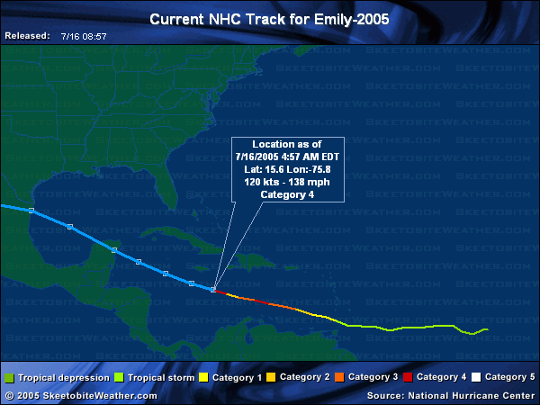
New advisory is out
Quote:
Hurricane Emily Advisory Number 22
Statement as of 5:00 am AST on July 16, 2005
At 5 am AST...0900z...the center of Hurricane Emily was located near
latitude 15.6 north... longitude 75.8 west or about 180 miles...
285 km... south-southeast of Kingston Jamaica and about 440
miles... 705 km...southeast of Grand Cayman.
Emily is moving toward the west-northwest near 18 mph...30 km/hr...
and this general motion is expected to continue for the next 24
hours.
Maximum sustained winds are near 140 mph...220 km/hr...with higher
gusts. This makes Emily is a category four hurricane on the
Saffir-Simpson hurricane scale. Some fluctuations in strength are
possible during the next 24 hours.
Hurricane force winds now extend outward up to 70 miles...110 km...
from the center...and tropical storm force winds extend outward up
to 150 miles...240 km. For Jamaica...hurricane force winds may
occur in gusts later today along the coasts...with possible
sustained hurricane force winds at higher elevations...especially
above 3000 feet.
The estimated minimum central pressure is 950 mb...28.05 inches.
So she's gettin bigger and more powerful too?
Wowie.
'shana
|
danielw
|
| (Moderator) |
| Sat Jul 16 2005 09:14 AM |
|
|
|
|
HURRICANE EMILY DISCUSSION NUMBER 22
NWS TPC/NATIONAL HURRICANE CENTER MIAMI FL
5 AM EDT SAT JUL 16 2005
AIR FORCE RECON DATA NEAR 06Z INDICATED THE CENTRAL PRESSURE HAD FALLEN TO 953 MB...AND A 700 MB FLIGHT-LEVEL WIND OF 131 KT...OR 118 KT EQUIVALENT SURFACE WINDS...WAS OBSERVED IN THE NORTHEAST QUADRANT DURING THE OUTBOUND LEG. GIVEN THAT THE 15 NMI DIAMETER EYE HAS CLEARED OUT NICELY SINCE THE RECON FLIGHT...AND THAT ODT
VALUES OVER THE PAST 1.5H HAVE BEEN T6.5/127 KT...THE INTENSITY FOR THE ADVISORY IS BEING CONSERVATIVELY INCREASED TO 120 KT. THE IMPRESSIVE OUTFLOW PATTERN ALSO CONTINUES TO IMPROVE.
THE INITIAL MOTION REMAINS 285/16. EMILY HAS BEEN ON A 285 DEGREE HEADING FOR THE PAST 48 HOURS...AND I SEE NO INDICATIONS THAT THAT MOTION SHOULD SIGNIFICANTLY CHANGE ANY TIME SOON. UPPER-AIR DATA AT 00Z INDICATES 24-HOUR 700-400 MB HEIGHTS ACROSS FLORIDA HAVE INCREASED BY ABOUT 20 METERS. THIS WOULD SUGGEST THAT...AT LEAST IN THE SHORT TERM...EMILY SHOULD CONTINUE ON ITS CURRENT MOTION AND PASS MORE THAN 60 NMI SOUTH OF JAMAICA LATER TODAY. BEYOND THAT...THE MODELS ARE IN REASONABLE AGREEMENT ON EMILY MAKING LANDFALL ALONG THE NORTHEASTERN YUCATAN PENINSULA IN ABOUT 48 HOURS. BY 72 HOURS...A FAIRLY VIGOROUS SHORTWAVE TROUGH CURRENTLY APPROACHING THE U.S. PACIFIC NORTHWEST IS FORECAST TO DIG EAST-SOUTHEASTWARD INTO THE CENTRAL U.S. AND WEAKEN THE SUBTROPICAL RIDGE ACROSS THE NORTHERN GULF OF MEXICO. THIS MAY ALLOW EMILY TO BRIEFLY MOVE MORE NORTHWESTWARD...BEFORE TURNING BACK TOWARD THE WEST AS THE SHORTWAVE TROUGH MOVES QUICKLY AWAY FROM THE AREA AND ALLOWS THE RIDGE TO BUILD STRONGLY WESTWARD. LOCATION OF A SECOND LANDFALL IS DIFFCULT TO PREDICT AT 96 HOURS...BUT THE MOST LIKELY AREA APPEARS TO BE FROM SOUTHERN TEXAS TO NORTHEASTERN MEXICO.
full text here:
http://www.nhc.noaa.gov/text/refresh/MIATCDAT5+shtml/160857.shtml
highlighted for emphasis~danielw
GHCC satellite frame of outflow.
http://weather.msfc.nasa.gov/GOES/GOES084520051973KGhNc.jpg
| rmbjoe1954 |
| (Weather Master) |
| Sat Jul 16 2005 10:25 AM |
|
|
|
|
It appears Cacncun is threatened by the models; but if that trough entrenches itself for a while I see a potential turn towards Texas.
| Clark |
| (Meteorologist) |
| Sat Jul 16 2005 12:53 PM |
|
|
Here we go again...recon reports pressure is down to 944mb and winds up to 145mph. Emily's now a midrange category 4 hurricane with an outside shot of further strengthening before the next eyewall replacement cycle.
It should be noted that shear tendencies to the west of the storm are highly negative, i.e. the storm is entering an increasingy favorable region as it moves along relative to what that area was looking like just a day ago. As seen yesterday, convection on the north and east sides of the storm is being enhanced by very favorable divergent upper-level winds. Outflow to the south and west is a little pinched, but it certainly isn't stopping the storm from deepening.
Ed has more in the met blogs...
| Margie |
| (Senior Storm Chaser) |
| Sat Jul 16 2005 01:37 PM |
|
|
|
|
Good morning everyone. Just up and see that Emily is a strong Cat 4 - no surprise, as I still think she'll reach Cat 5 today.
I'm VERY glad she is going to go fairly south of Jamaica. She looks like a mean little buzzsaw. Even the visual radar looks very impressive. But it looks bad for the Yucatan coastline.
A question - in the NHC Discussions, what does CDO stand for?
|
SkeetoBite
|
| (Master of Maps) |
| Sat Jul 16 2005 01:40 PM |
|
|
|
|
For those without the link, these will take you to the latest visible and infrared images of Emily.


| Biowatch |
| (Verified CFHC User) |
| Sat Jul 16 2005 01:50 PM |
|
|
|
|
Feeling very uneasy again this morning regarding the Yucatan. With my daughter on the east coast of that peninsula, wondering what the potential storm surge might be for that area. Reports have little information regarding the potential effects of Emily there. Most reports detail Jamaica and Texas possiblilities, but little discussion of effects on Yucatan. I learned yesterday on this site that it is very low lying, but is the small eye an indication of a small tidal surge?
| Unregistered User |
| (Unregistered) |
| Sat Jul 16 2005 01:50 PM |
|
|
Hey Clark--
Given that Emily has ramped up considerably and may intensify a bit more, is there any way that she might steer on a slightly more northerly heading. Nothing significant, just perhaps a subtle change from ~285 to perhaps, say, ~290 or 295. Isn't it possible for very strong storms to eat into ridges a bit? Just was thinking perhaps she might miss the Yucatan that way, and perhaps spin down a bit in the Gulf of Mexico. As it looks now, the Yucatan Peninsula is going to take some serious heat from this thing.
Thanks. Appreciative of your insight, as always.
| Margie |
| (Senior Storm Chaser) |
| Sat Jul 16 2005 02:01 PM |
|
|
|
|
Quote:
Feeling very uneasy again this morning regarding the Yucatan. With my daughter on the east coast of that peninsula, wondering what the potential storm surge might be for that area. Reports have little information regarding the potential effects of Emily there. Most reports detail Jamaica and Texas possiblilities, but little discussion of effects on Yucatan. I learned yesterday on this site that it is very low lying, but is the small eye an indication of a small tidal surge?
I would be uneasy as well. The main thing is the intensity. The stronger the storm the stronger the surge. Ideally she would want to be located south of where the eye hits land.
Are you in touch with your daughter? How close to the shore is she? Yucatan should already be preparing for a hit and so she should already have info about where to go.
| HCW |
| (Storm Tracker) |
| Sat Jul 16 2005 02:04 PM |
|
|
|
|
Live radio feed from jamaica
http://www.go-jamaica.com/power/
| MichaelA |
| (Weather Analyst) |
| Sat Jul 16 2005 02:07 PM |

|
|
|
If Emily reaches Cat 5 intensity, would that make her the earliest Cat 5 storm in history? (have there been others in July?)
| Biowatch |
| (Verified CFHC User) |
| Sat Jul 16 2005 02:11 PM |
|
|
|
|
Good morning Margie.....thanks for the reply. No, I am not able to contact my daughter......she is working for an organization called Global Works which has a program in the Peninsula. Her printed itinerary shows they were scheduled to head to a small island directly off the east coast on Sunday night. She is not too far from it now. Hoping someone has some sense to move the group of teenagers(18 of them) out of the area. I know they are not far from the east coast now. I think it is still a hike to the closest airport. Last heard from her 4 days ago.
| MichaelA |
| (Weather Analyst) |
| Sat Jul 16 2005 02:20 PM |
|
|
|
|
Quote:I would certainly expect the group knows about the storm and is taking the necessary precautions. I know that's not much solace to you. Have you called Global Works?
Good morning Margie.....thanks for the reply. No, I am not able to contact my daughter......she is working for an organization called Global Works which has a program in the Peninsula. Her printed itinerary shows they were scheduled to head to a small island directly off the east coast on Sunday night. She is not too far from it now. Hoping someone has some sense to move the group of teenagers(18 of them) out of the area. I know they are not far from the east coast now. I think it is still a hike to the closest airport. Last heard from her 4 days ago.
| Margie |
| (Senior Storm Chaser) |
| Sat Jul 16 2005 02:26 PM |
|
|
|
|
Quote:
Good morning Margie.....thanks for the reply. No, I am not able to contact my daughter......she is working for an organization called Global Works which has a program in the Peninsula. Her printed itinerary shows they were scheduled to head to a small island directly off the east coast on Sunday night. She is not too far from it now. Hoping someone has some sense to move the group of teenagers(18 of them) out of the area. I know they are not far from the east coast now. I think it is still a hike to the closest airport. Last heard from her 4 days ago.
No, they won't be going to any small island off the east coast Sunday night. Emily will be hitting the Yucatan Sunday night, and everyone in the Yucatan knows that. Seeing the strong CAT 4 this morning will light a fire under officials. She'll be safely inland.
I would contact Global Works headquarters and hassle them until they agree to find out where she is. Remember afterwards communications may be out for a week or so in those coastal areas.
| Margie |
| (Senior Storm Chaser) |
| Sat Jul 16 2005 02:26 PM |
|
|
|
|
New thread.
| Biowatch |
| (Verified CFHC User) |
| Sat Jul 16 2005 02:36 PM |
|
|
|
|
thanks, Michael, for the reply. I think I got lost in this thread as it ended....I do have numbers to contact the organization, and will. I just did not want to look like an alarmist as hurricanes can be so fickle. I does not look like there really is a safe place to go reviewing all of the computer models on the underground site. All put them over the Yucatan....some even more south than I thought. I know she will eventually call and ask advice as she knows I have tracked hurricanes for years. Different when its your own family out there......you lose a little objectivity.
| HCW |
| (Storm Tracker) |
| Sat Jul 16 2005 02:37 PM |
|
|
|
|
moved it to the new thread
| ftlaudbob |
| (Storm Chaser) |
| Sat Jul 16 2005 02:38 PM |
|
|
|
|
Having lived in Playa Del Camen on the Yucatan for 3 years,I have this morning offerd my friends that are there a place to stay here with me.Also I am working with them for flight arrangments to get then out of there.Anyone who has been there knows,there is no place there that is safe,and I mean no where.Many times I used to sit on the beach there and say to myself Ïf a major hurricane ever hit here it would wipe this town out".Well it looks like that is what will happen.For those that have never been there,it is one of the coolest places on this earth.Please pray for all those who can not get out in time.
| Biowatch |
| (Verified CFHC User) |
| Sat Jul 16 2005 03:11 PM |
|
|
|
|
Thanks again, Margie.....I hope you are right in them being aware of the situation in the Yucatan. I had not thought of the communications being out for a week afterwards..a very good point...I guess I will be signing off to contact the organization with fingers crossed......
| jusforsean |
| (Verified CFHC User) |
| Sat Jul 16 2005 04:48 PM |
|
|
Hi,
anyone have up to date info on the next td 6? I am trying to find the best way to keep up to date on the disturbances that the news and nws doesnt update on yet.
Thanks
jusforsean
| MichaelA |
| (Weather Analyst) |
| Sat Jul 16 2005 06:16 PM |
|
|
|
|
Quote:I usually read the Tropical Weather Discussion at the NHC site.
Hi,
anyone have up to date info on the next td 6? I am trying to find the best way to keep up to date on the disturbances that the news and nws doesnt update on yet.
Thanks
jusforsean
| jrhurricane |
| (Registered User) |
| Sat Jul 16 2005 08:46 PM |
|
|
Yah...I did jsut see the map of Emily. You can tell it did shift a bit direction...Does anyone seem to know what directions will be getting a direct hit. I was thinking that Central Coastal Texas wouldn't see anything, but now I see that they might and all the way up to Louisiana, which I already did know that they would maybe see TS force winds possibly? Or possibly TD force winds? I do think that anyone in the US from Southern Texas to Eastern or Western Lower Louisiana do need to keep an eye on this storm as the track is probably still uncertain? Question for the Meteroligist's-What do you think the track will be...which I already do know some of them already are certain about the track and some are not, but I really am uncertain that is why I am asking about Emily's Track.