| Clark |
| (Meteorologist) |
| Fri Dec 30 2005 11:51 AM |
|
|
The 2005 Atlantic Hurricane Season continues to surprise and amaze. In conjunction with a persistent upper-level low in the eastern Atlantic, a surface low developed yesterday and quickly became organized this morning and early afternoon, resulting in the development of the season's 27th named storm of the season, Zeta. Only one other storm that I can recall -- "Alice2" of 1954 -- formed this late in the year, lasting into January 1955; of course, there are likely others in or out of the database as well. Zeta is also the season's 6th Greek named storm and, in a punny twist of fate, is often used by meteorologists as the symbol to represent vorticity -- or, as Jim Cantore puts it, spin -- a feature which tropical cyclones certainly have a lot of.
Zeta formed in a somewhat peculiar manner, with elements of Vince, Delta, and Epsilon (location), elements of some of this season's western Atlantic storms (enhancement by an upper-level low), and perhaps even elements of pure tropical development (convection fires within a mid-level feature, spins up a low-level circulation, convection dies out, the circulation organizes, and we get a tropical disturbance out of it). We'll watch it as we head into the new year -- needless to say, Zeta will almost assuredly be the last named storm of the 2005 season. It may just make it to 2006 as it slowly moves toward the west-northwest over the next couple of days.
More coming soon.
Event-specific links
(click image for full-size -- now all current!)

Skeetobite Track Map of Zeta
SSD GOES Floater on Zeta
S. Fla. WMD Model Plot
Thanks to Random Chaos for the following links:
NASA GHCC - 6 Frame IR Animation
NASA GHCC - 12 Frame IR Animation
PSU IR Loop
| Random Chaos |
| (Weather Analyst) |
| Fri Dec 30 2005 11:54 AM |

|
|
|
More visual links (duped from my other post):
IR Images of Zeta:
NASA GHCC - 6 Frame IR Animation
NASA GHCC - 12 Frame IR Animation
PSU
| CaneTrackerInSoFl |
| (Storm Tracker) |
| Fri Dec 30 2005 12:45 PM |

|
|
|
Haha. This is ridiculous. Just to ring in the new year, a new tropical storm. 2005 is really running right up to the wire.
| emackl |
| (Storm Tracker) |
| Fri Dec 30 2005 01:41 PM |
|
|
Sorry if this is a stupid question but if Zeta makes it to Jan 1 will it be listed in the 2006 storm history as well?
What a crazy year.
Jackie
| ChessieStorm |
| (Weather Watcher) |
| Fri Dec 30 2005 01:44 PM |
|
|
If Zeta makes it to January 1st, it will still go under the 2005 storm season since it was named in 2005.
Obviously any storm forming after January 1st will go under the 2006 season setup
| Jenny |
| (Verified CFHC User) |
| Fri Dec 30 2005 03:14 PM |
|
|
|
Just when I thought is was safe to put away all the hurricane supplies.

| Margie |
| (Senior Storm Chaser) |
| Fri Dec 30 2005 03:54 PM |

|
|
|
Thank you Franklin for another memorable quote:
ALTHOUGH THE ATMOSPHERE SEEMS TO WANT TO DEVELOP TROPICAL STORMS AD NAUSEAM...THE CALENDAR WILL SHORTLY PUT AN END TO THE USE OF THE GREEK ALPHABET TO NAME THEM.
He also noted the bands looking more ragged (you were right RC) and the westerlies already starting to show an effect (this can be seen on IR sat images today as well...as the storm has been moving west today, the circulation to the west dissipates past about 38W).
| eduardo sanchez |
| (Registered User) |
| Fri Dec 30 2005 04:40 PM |
|
|
|
Uno mas, para despedir 2005 llega zeta increible pero cierto, uno mas en la larga lista, no termina ya la sesion?? feliz año nuevo zeta.
One but, to dismiss 2005 arrives zeta incredible but certain, one but in the long list, does not finish the session already? zeta Happy New Year.
Rough translation by Babelfish~danielw
| Random Chaos |
| (Weather Analyst) |
| Fri Dec 30 2005 07:00 PM |
|
|
|
|
I'm looking at IR and it looks like Zeta's flaring convection again. SSMIS just barely missed the core of the storm, so I don't have any microwave imagery, but I'd say it's strengthening again. My guess: it'll definately still be a TS tomorrow morning, and quite possibly also for tomorrow evening.
The GHCC NHE sat seems to be having problems, so I can't compare the images to what I was looking at earlier. Oh, note that if you click the 12 frame version I linked above, you can just change the number of frames anywhere from 2 to 30 at the end of the URL.
| Margie |
| (Senior Storm Chaser) |
| Fri Dec 30 2005 07:44 PM |
|
|
|
|
I thought the convection flareup might be due to shear. I have to admit the most recent frames the blowup of convection is right over the center.
I don't think it'll get the chance to wrap around...convection, and all the outflow, is very asymmetrical -- mainly NNE of the center, and the LLC is exposed to the south. If Zeta wasn't moving west, may have had a better chance...convection is still not making it past about 38W, and the center is by now fairly close to 37.5W. And possibly some dry air continues to wrap around the south and up into the east part of the core.
---
Latest SSC classification has switched to subtropical...explanation, please. Is this referring to the large majority of convection now being far removed from the center (and possibly the windfield being more spread out?)...or does it mean the recent increase in convection is more baroclinic in nature?
DATE/TIME LAT LON CLASSIFICATION STORM
30/2330 UTC 25.7N 37.3W ST2.5/3.0 97
30/1145 UTC 24.7N 36.4W T2.5/2.5 97
30/0545 UTC 24.3N 36.4W T1.0/1.5 97
| Clark |
| (Meteorologist) |
| Fri Dec 30 2005 10:08 PM |
|
|
The Dvorak classifications are all subjective (except for the Univ. of Wisconsin estimates, which are based off of an objective algorithm that is being tested), so changes can somewhat be based upon the judgement of the individual forecast. It's all supposed to be based off of satellite appearance, so I don't think the other factors come directly into consideration -- maybe indirectly. I don't really have a good answer one way or the other, though, beyond forecaster perrogative. If someone has a tad more information, though, I'd love to hear it.
| Margie |
| (Senior Storm Chaser) |
| Fri Dec 30 2005 11:12 PM |
|
|
|
|
I found out it was the windfield...in discussion #3. They can see the quickscat, but we can't.
THE QUIKSCAT DATA INDICATED TROPICAL STORM-FORCE WINDS FARTHER FROM THE CENTER IN THE EASTERN SEMICIRCLE THAN PREVIOUSLY THOUGHT.
Also that discussion started off kind of funny:
ZETA IS ROUGHLY HALF OF A TROPICAL STORM... WITH MOST OF THE CONVECTION EAST OF THE CENTER... BUT STILL SOME OF IT NEAR THE FAIRLY TIGHT CIRCULATION CENTER.
It looks like the exposed LLC is just starting to move more west...but the convection is not following. There is still convection over the center but I wonder how long that will remain.
| Clark |
| (Meteorologist) |
| Fri Dec 30 2005 11:15 PM |
|
|
Well, the NHC can see them...I'm not sure they are supposed to go into the (separate) Dvorak classifications, however. While the forecasters most likely know how to use the Dvorak technique, it's a separate center (or centers) that performs the classifications. I'm sure they look at the QuikSCAT, but it's not a factor in the Dvorak classification...unless they have decided to take the tropical vs. subtropical factor out of the satellite image classification whatsoever.
| Margie |
| (Senior Storm Chaser) |
| Fri Dec 30 2005 11:19 PM |
|
|
|
|
Oh sorry, you're right, I just mixed apples and oranges. Well it still follows though that the windfield is more indicative of a subtropical storm, anyway, if the strongest winds are mostly further from the center.
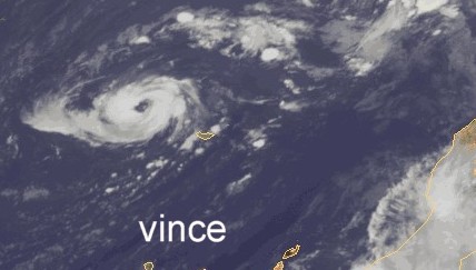
| Multi-Decadal Signal |
| (Weather Guru) |
| Sat Dec 31 2005 04:22 AM |
|
|
What the non weather-bug world sees .
http://www.nytimes.com/2005/12/31/national/31zeta.html
Happy New Year to All...
| eduardo sanchez |
| (Registered User) |
| Sat Dec 31 2005 05:25 AM |
|
|
|
|
Last images of satellite shows Zeta better organiced , forecast indicates that after of 12 hours began to be weaken, but the season has to us already customary to surprises, Epsilon resisted to be debilitated until becoming hurricane, we will see that it happens with Zeta.
| Frog |
| (Registered User) |
| Sat Dec 31 2005 05:56 AM |
|
|
Quote:
Uno mas, para despedir 2005 llega zeta increible pero cierto, uno mas en la larga lista, no termina ya la sesion?? feliz año nuevo zeta.
One but, to dismiss 2005 arrives zeta incredible but certain, one but in the long list, does not finish the session already? zeta Happy New Year.
Rough translation by Babelfish~danielw
Margie, I think the translation would rather be :
Yet another one, Zeta arrives to say a farewell to 2005, unbelievable but true, another one in this long list, wasn't the season supposed to be over ?! Happy New Year Zeta.
And Happy New Year to you all folks !
| eduardo sanchez |
| (Registered User) |
| Sat Dec 31 2005 06:18 AM |
|
|
|
|
Thanks to all for your help.
| Random Chaos |
| (Weather Analyst) |
| Sat Dec 31 2005 09:50 AM |
|
|
|
|
Well, microwave imagery doesn't show to great a storm. NHC put out their 10am advisoriy - winds up to 50kts but they agree the storm doesn't look great.
Based on the forcast from the NHC, we're going to have the first system of 2006 also...as Zeta spans into the new year.
--RC
| HanKFranK |
| (User) |
| Sat Dec 31 2005 12:27 PM |

|
|
|
no real reason the shear should abate. fitting way to end such a year as 2005, with a storm... even a shear-eaten one.
i guess clark is going to have to update his blog one more time for the last-minute addition. i mentioned it on the last thread after it was switched, so worth saying again: franklin has to be pinching himself over the precocious hurricane epsilon review, which began by stating that epsilon was the last storm of 2005. what a year it was; saying a storm that ate it on december 8th was the last wasn't even safe.
HF 1727z31december
| ltpat228 |
| (Storm Tracker) |
| Sat Dec 31 2005 12:34 PM |

|
|
|
Quote:
What the non weather-bug world sees .
No more hurricanes for 2005.
Remember, the hurricane season ended the last day of November........
| Hugh |
| (Senior Storm Chaser) |
| Sat Dec 31 2005 01:03 PM |
|
|
Any signs of Alberto forming in the next week or so? Or is there actually a chance we may go a few weeks with NO tropical development???
| Margie |
| (Senior Storm Chaser) |
| Sat Dec 31 2005 02:40 PM |
|
|
|
|
Morning all. No surprises with Zeta...it appears that Zeta is tilted vertically by the shear. The center of the LLC appears to be just exposed, but still connected to the small central area of convection which can also be seen to spin in tandem with it, just to the east. All the remaining convection is pushed to the NE, and most of the LLC is exposed. After a little WNW movement last night, it appears that Zeta is almost stationary. I think the lack of movement west has helped extend Zeta's lifetime a bit.
Last night you could see on the upper level wind diagram that the winds were diverging a bit just to the west of Zeta. This morning's discussion reads in part:
ZETA HAS FOUND A RELATIVELY SOFT SPOT BETWEEN STRONG SHEAR TO THE NORTH AND SOUTH OF THE CYCLONE...BUT STRONGER WESTERLIES LIE AHEAD AND THIS FLOW WILL CONTINUE TO POUND AWAY AT ZETA.
I have a feeling that the remaining convection will go very quickly, as happened with Epsilon, as soon as the westerlies really hit, but with a strong well-organized low and mid level circulation, and continued convection being fueled by the shear, Zeta is hanging in there today.
HF--have a funny msg for you, check your PMs
* * * * * * *
Oh, and, Happy New Year, everyone! I didn't think about Dec 31st, when I coined the 2005 season "SOBR," but it is the one legitimate night of the year we can go out and tie one on and recollect (or forget, whichever one prefers) the past seven months. However I've heard from a reliable source that mets...oh well never mind.
| HanKFranK |
| (User) |
| Sat Dec 31 2005 11:10 PM |
|
|
|
|
zeta is clinging to the variety of life it's being alotted in the marginal, quirky late season environment. the official has been adding to the projected life of the system as it persists, though it could wink out as fast as epsilon did on december 7th-8th or hang around for days and such changes aren't very predictable given what we know about the oddball thermodynamic environments that allow these off-season types. given that the convection tends to be a little more offcenter and deeper than what epsilon had, i'd say it will have a harder time sustaining. the prediction through january 2nd looks as good as any.
anyhow, as far as there being more offseason systems... calling the season done doesn't seem to ever be right, so might as well go ahead and predict three or four offseason systems to tide us over until our the hyper active month of may 2006 arrives... as predicting things to be quiet doesn't seem to carry any weight, calling them active might have the contrary effect? 2006 appears to be set up for la nina, and quite often those years don't really get going until some time in august anyway, so it's actually quite possible (eg. 1988, 1998, 2000, with an odd june storm in 1999 and 2001).
i'll believe it when i see it, though.
HF 0410z01january
| Random Chaos |
| (Weather Analyst) |
| Sun Jan 01 2006 12:54 AM |
|
|
|
|
Well, Happy New Year and welcome Zeta to the first storm of 2006!
Looking at Sat images, Zeta looks almost as good again as it did last night, and far better than it looked mid-day today. Convection is strong and appears to be wrapping—albiet weakly so—the core low pressure. You can see a hole appearing right on the SW edge of the convection mass half overlaping out to sea. This is located in approximately the same location as the current estimated position on the SSD Tropical Forcast overlay. I'd say that the core is at least partially still under the convective mass, but over 50% exposed. It's amazing Zeta is hanging on as well as it is. Given it's tenacity, if there wasn't shear we could see a strengthening storm that might have hit minimal hurricane strength. As it is, the shear will continue to limit it, and eventually rip it appart. If, somehow, it manages to survive the shear, we could still see some minor strengthening in several days. I doubt it will survive the shear though, but then, given the past few months of cold water Atlantic storms, I wouldn't count on that.
--RC
P.S. - one change to the forums I'd like to see is the allowance of HTML special characters such as —, °, etc. That would make it so much easier to type out posts

| Clark |
| (Meteorologist) |
| Sun Jan 01 2006 01:59 AM |
|
|
Well, no matter what's going on or what happens in the future, there's one statement I can officially make -- the 2005 hurricane season is OVER. Zeta's still around, but it's 2006...'nuff said.
| Doombot! |
| (Weather Guru) |
| Sun Jan 01 2006 02:24 AM |

|
|
|
Happy new year!
Wouldn't this still be the 2005 season? (i.e. If Alberto formed right now wouldn't we be in both the 2005 and 2006 season at the same time?)
| Rich B |
| (British Meteorologist) |
| Sun Jan 01 2006 06:47 AM |
|
|
Nah,
if Alberto formed right now it would actually fall into the 2006 Season - after all it would be taking the first name on the 2006 list too. Zeta is a 2005 Season storm as it formed prior to the end of the year.
| TDW |
| (Weather Watcher) |
| Sun Jan 01 2006 08:56 AM |
|
|
I'm not sure how many have seen it (or if it has been mentioned here), but the television show Modern Marvels recently had a new episode on Hurricane Tech. Based on references in the show it seems to have been produced after Beta this year.
It has some interesting talk about the long way technology has come in helping predict hurricanes. They also interview some of the NHC's staff. I'm not sure when it will run again, but they show the same episodes many times over.
If you've got TiVo this is one worth recording.
Happy New Year to all.
| eduardo sanchez |
| (Registered User) |
| Sun Jan 01 2006 09:13 AM |
|
|
|
|
Happy New Year from spain! Creo que el asunto de los nombres no deja lugar a dudas; el sistema que se forme a partir de ahora es de la sesion de 2006, ya veremos que ocurre Enero, desde Junio no ha habido mes sin que se forme un sistema,pero continuamos rompiendo records y Enero quizás no quiera ser menos, pero es muy pronto para que comienze la nueva temporada.O tendremos que acostumbrarnos a 12 meses de temporada??? SALUDOS DESDE ESPAÑA, AMIGOS!!
| Doombot! |
| (Weather Guru) |
| Sun Jan 01 2006 02:09 PM |
|
|
|
|
Is it just me or is Zeta "eyeing-up"? Could we have the earliest forming hurricane or record?
| HanKFranK |
| (User) |
| Sun Jan 01 2006 03:54 PM |
|
|
|
|
don't think it's developing an eye or anything. Actually had a banding type eye feature back on december 30, but that was just a function of scant convection and a dry environment more likely than not. That said, convection has bursted near the center this afternoon. nhc hasn't upped the intensity on their latest advisory, but it isn't looking any worse for the wear, and since it's stopped pushing west and is showing evidence of becoming vertically deeper.. i wouldn't be surprised if it stays stalled or starts drifting east.
just an off-the-wall note. long range gfs has been showing a rather pronounced 200mb ridge developing in the deep tropics east of the islands and migrating to over the caribbean. such a feature, if it verifies... would be somewhat anomalous and might be very interesting if a frontal tail or vorticity lobe were to tail down into it.
HF 2051z01january
note: i'll summarize the early 2006 forecasts made on here in a forum post to start of the '06 storm forum when mike or john or christine puts it up. zeta hanging around has already given us the first '06 storm activity in a really odd fashion, but it's really an '05 storm.
doofy me... it's already up. -HF
| Margie |
| (Senior Storm Chaser) |
| Sun Jan 01 2006 05:41 PM |
|
|
|
|
Oh my goodness, I go away for a day and the flow from the jets has shifted and wind shear has reduced, as can definitely be seen by the appearance of outflow on the western side, expanding into the SW. And not only that, but an area of even less shear is headed for Zeta, so we could even see strengthening into a hurricane briefly, tonight. Actually...I think that's going to be very likely. And as the shear has reduced, the movement west has resumed, looks like SW.
Convection remains shallow and still hasn't been able to wrap around to the south, leaving the LLC exposed there. WV loop clearly shows much drier air to the south, and very clearly-defined boundaries, but it appears that is being pushed a little more south for the moment, and that the air wrapping into the cyclone now is going to have little more moisture. But right now there is still dry air being pulled in from the south. I expect to see the outflow continue to wrap around to the south as moister air is pulled into the cyclone from the NW.
It would really be interesting if Zeta managed to hang on long enough to be steered SW close enough for a recon.
So...I went to NRL website and what's the deal with the SSMI?
| Random Chaos |
| (Weather Analyst) |
| Mon Jan 02 2006 08:38 PM |
|
|
|
|
This morning it looked like Zeta was ready to die. Now it looks stronger than I think it ever looked. Convection is becoming more symetrical, and there is a very strong eye-like feature visible on microwave.
NRL Microwave
NRL Mosaic
IR looked good until the last couple of frames when there appeared to be some dry air intrusion in the southeast quadrant, but overall I think it's strengthening.
P.S. - now that it is 2006, when do we get the 2006 News Talkbacks forum for Zeta?

| Margie |
| (Senior Storm Chaser) |
| Mon Jan 02 2006 09:03 PM |
|
|
|
|
I didn't post here last night or today but I've been keeping up with Zeta. Here's a different point of view. Take a look and tell me what you think. It's done strengthening now and if you take a look at the WATL you'll be able to see the impact from the westerlies is beginning, and it'll be really evident by midnight or so. I think this shear has been enhancing the convection late this afternoon and early evening.
Take a look at the floater WV as well and you'll see that as the trough approached the air around Zeta became less dry. That 'electric shock' look to the convection (I don't mean the transverse banding on the outflow, but the core convection) the last couple frames is due to shear this time, not dry air intrusion.
It is the beginning of the end for the convection. However I don't have much information on how deep that trough is, or if it has weakened anywhere, and it is a possibility that with Zeta's continued slip to the south it may just survive (which is what the GFDL saw). But I think that's an outside chance. If it does, there's another area of low shear behind the trough.
| CaneTrackerInSoFl |
| (Storm Tracker) |
| Mon Jan 02 2006 09:57 PM |
|
|
|
|
How many times have we seen this, this season?
...ZETA STRENGTHENED AGAINST ALL ODDS AND FORECASTS...
Amazing. Mind boggling. Fascinating. Any other adjectives?
| Clark |
| (Meteorologist) |
| Mon Jan 02 2006 10:59 PM |
|
|
Zeta sorta looks like it's being sheltered from the worst of the shear by a weak upper-level low to its southwest, perhaps a feature that tailed off at the bottom of the trough that has been approaching it. It also appears that this trough is about to fracture, likely missing the storm until the next batch of westerlies gets to it in 24 hours or so.
Zeta's been helped by being as far south as it is. This upper low appears to be pivoting to the south and east around the southern side of the storm; if Zeta is deep enough vertically, it might be turned a bit more to the west or west-northwest for a brief period of time in response to this feature. It's probably deeper than it was a day or two ago, but still not terribly deep -- probably "moderately deep," a vague term I'm using to suggest a storm that probably extends to the 300-400mb level. If it moves further north, Zeta will meet those westerlies; even if it doesn't, the westerlies will likely get it at some point. There's a small chance that the upper low and the "sheltering" environment it seems to be providing sticks around and keeps Zeta going for the next few days, but any drastic change and the storm is done for.
It briefly displayed an eye-like feature on microwave imagery in the late afternoon hours, but that is gone now. Nevertheless, it has the appearance of a strong tropical storm on both microwave and conventional satellite imagery and was probably stronger in the late afternoon hours...but appears to have leveled off since and may have slightly weakened. I've got a hunch that the aforementioned trough that looks to be fracturing just to the west of the storm likely narrowed quite a bit in scope and actually helped contribute to the organization of the storm -- and not in weakening it as had been forecast. It has a little bit to do with the outflow and enhanced diffluence, topics Margie hinted at in her analysis. It's tough to predict such an evolution, however, and even tougher for these wildly atypical systems. The upper-low now is likely helping to maintain the cooler temperatures aloft; as a result of everything I've mentioned, I'd expect a steady-state storm for the next 24 hours or so (except for maybe any "corrections" upward in intensity) followed by slow weakening, perhaps a tad slower than the NHC forecast. Once the shear hits it, however, it should die fast.
We'll see how this all pans out, but it's hard to have a *lot* of confidence in anything but its ultimate demise right now.
| Goosus |
| (Verified CFHC User) |
| Tue Jan 03 2006 01:15 AM |
|
|
This storms looks pretty good on IR and WV loops. It looks like outflow is pretty strong except to the south and southeast, and I'm seeing the hint of some banding features as well.
Almost no one has been around here, and I was out of town at the time, but was it just my imagination that for more than half a day back on the 30th this had a eye? Someone mentioned above that it was just a trick of dry air entrainment, but it looked quite symetrical, stayed pretty much center of the storm, and persisted for longer than you would expect from other causes. I believe it was at the time of the first 2 advisories that I saw it.
Does anyone know where we could find some of these images or loops to take a better look?
| UKCloudgazer |
| (Verified CFHC User) |
| Tue Jan 03 2006 03:53 AM |
|
|
|
|
Woke up this morning with Zeta looking like a storm that is thinking about becoming a hurricane. And I was sceptical about GFDL all week - looked ludicrous compared to the other models earlier in the year but now it is making them look weedy. GFDL has generally tended to be bullish, but very often right. NHC say there has been no known hurricane form in January. If Zeta does, it will be the final straw in Margie's 2005 SOBR effect.
That corner of the Atlantic certainly seems to be a breeding ground for storms just now.
Happy new year
B
| Spoken |
| (Weather Hobbyist) |
| Tue Jan 03 2006 04:43 AM |
|
|
"AGAINST ALL ODDS," it seems as if the NHC is expecting Zeta to remain a tropical storm for perhaps 24 hours longer than they'd previously been expecting. That is to say there are currently five little cyclone symbols showing in the tropical forecast points, where before there'd seemed to have been rarely more than two or three.
| Random Chaos |
| (Weather Analyst) |
| Tue Jan 03 2006 09:27 AM |
|
|
|
|
Well, the GFDL model is officially nuts. It's calling for FL winds to Cat 3? (That's surface winds to Cat 2).
Given what Zeta's done so far, and how nice it looks on IR, this might not be so far fetched as one would think. We are again seeing an eye-like feature on microwave., though it is considerably more defined in the northern half of the storm. At this rate, Energizer will start using the 2005 hurricane season in their ads - it keeps going and going and ....
Edit:
Ok, 10am NHC update is out, and they are also seeing this eye-like feature on microwave. They are also saying that conditions should be favorable for strengthening later today.
| Margie |
| (Senior Storm Chaser) |
| Tue Jan 03 2006 10:59 AM |
|
|
|
|
It looks like now that the shear is reducing, with the lopsided convection, it is starting to oscillate a bit. I don't know if it was tilted a bit from the SW shear, if the LLC is going to reform under the curved band of convection (I kind of doubt that) or it is just trying to get lined up vertically. Or maybe it is moving in response to that weak upper low Clark mentioned.
Anyway, now that it appears it is about to make it past that trough (which wasn't too certain last night) I was surprised that they kept the forecast to 55kts for the next 24-36 hours...maybe they're just waiting until this aft to see if the trough splits, before increasing the intensity forecast. We can assume because Zeta's a hybrid, slightly cooler water temps won't affect it too adversely, and with the lower shear, it's likely going to intensify. Right now I don't see any reason it couldn't make it to say 75-90kts for a short time, if it gets in the right spot. But I don't know so much, so maybe Clark or HF will post more reasons pro or con with regards to the extent of possible strengthening over the next day or so.
Edit--
The quikscat link is back. 1742 UTC showed Zeta not that strong at the surface, centered at just about 23N41W, which seems a little odd. Guess it really did oscillate around.
Zeta's convection is almost all sheared off. The southernmost part of the TC is close to an area of 40kt of shear, dropping off to around 20 kts just north of the center, coming from the WSW. Instead of enhancing the convection, shear from this direction pushed it away, possibly because this air was drier or coming from a different height (possibly higher?).
However it is very close to an area of low shear that is approaching. Now it would benefit Zeta to more a little further north, but it looks like since Zeta weakened it is being steered WSW by the lower level flow. We have seen hybrids can survive w/very little convection. Zeta should be sticking around until the lower shear moves closer, or it gets an opportunity to move further north, where it will be able to strengthen.
Since Zeta's convection was enhanced by shear yesterday, and destroyed by shear today, it is clear that height and direction (and perhaps humidity level) of the various levels of shear are critical to an intensity forecast.
Got the 2006 signature going
|
|
|
v
| ltpat228 |
| (Storm Tracker) |
| Tue Jan 03 2006 04:37 PM |
|
|
|
|
Quote:
Well, the GFDL model is officially nuts. It's calling for FL winds to Cat 3? (That's surface winds to Cat 2).
What do you mean by "FL winds"?
Splain please, Lucy....
| Allison |
| (Weather Guru) |
| Tue Jan 03 2006 04:45 PM |

|
|
|
Quote:Quote:
Well, the GFDL model is officially nuts. It's calling for FL winds to Cat 3? (That's surface winds to Cat 2).
What do you mean by "FL winds"?
Splain please, Lucy....
I'm pretty sure Random meant "flight level" winds, not "Florida" winds...
Allison
| eduardo sanchez |
| (Registered User) |
| Tue Jan 03 2006 05:54 PM |
|
|
|
|
Efectivamente el modelo gfdl en su pasada de las 12z habla de vientos de categoria 3 pero a 950 mb. esto es a más de 800 metros de altitud, a nivel de la superficie serían de categoria 2, todo es posible, y no es extraño que tal como está la temporada esto pueda ocurrir, y Epsilon vale de ejemplo. ya veremos si se cumple este pronostico. saludos desde España.
| Lee-Delray |
| (Weather Master) |
| Tue Jan 03 2006 05:59 PM |

|
|
|
Please don't use FL like that, some of us have ulcers.
| Margie |
| (Senior Storm Chaser) |
| Tue Jan 03 2006 06:10 PM |
|
|
|
|
Eduardo es posible. NHC predice debilitando de la "trough." Pero un área de "low shear" estará llegando. Por mañana nosotros sabremos.
| ltpat228 |
| (Storm Tracker) |
| Tue Jan 03 2006 08:23 PM |
|
|
|
|
Quote:
Please don't use FL like that, some of us have ulcers.
Indeed, Lee!!!
FL is the abbreviation for my state of Florida.
I am trying to learn as well as understand what you people are saying when you use meteorlogical terms as I've had my fill of hurricanes in the 52 years I've been a Floridian.
Keeping it simple makes it much easier for me...lol.
| Randrew |
| (Weather Guru) |
| Tue Jan 03 2006 09:06 PM |

|
|
|
SO...ALTHOUGH YOU'VE
HEARD THIS FROM US BEFORE...WE EXPECT A WEAKENING TREND TO COMMENCE
TOMORROW.
THEN...A GRADUAL TURN
TO THE RIGHT IS ANTICIPATED IN RESPONSE TO THE APPROACH OF A LARGE
LOW PRESSURE SYSTEM. IF ZETA WEAKENS FASTER THAN INDICATED
HERE...IT WOULD PROBABLY FOLLOW A MORE WESTWARD TRACK IN 3-4 DAYS.
My question...even though I speak english...is...is Zeta going north and then west or does all of this depend on weather or not Zeta weakens before all this?
| Random Chaos |
| (Weather Analyst) |
| Tue Jan 03 2006 09:30 PM |
|
|
|
|
Zeta looks horrible on IR now...
Sorry about that Florida/Flight Level problem - to me FL is Flight Level because that's how most NWS meteologists seem to use it, and I've picked it up as that.
--RC
| Randrew |
| (Weather Guru) |
| Tue Jan 03 2006 09:45 PM |
|
|
|
|
Ya gotta love Avila....
Tropical Storm ZETA Discussion
--------------------------------------------------------------------------------
Home Public Adv Fcst/Adv Discussion Strike Probs Maps/Charts Archive
--------------------------------------------------------------------------------
000
WTNT45 KNHC 040231
TCDAT5
TROPICAL STORM ZETA DISCUSSION NUMBER 19
NWS TPC/NATIONAL HURRICANE CENTER MIAMI FL
10 PM EST TUE JAN 03 2006
ZETA IS A TENACIOUS CYCLONE AND BASED ON DVORAK CLASSIFICATIONS THE
WINDS ARE AT LEAST 55 KNOTS. THE CLOUD PATTERN IS IMPRESSIVE AND
CONSISTS OF AN AREA OF MODERATE CONVECTION NEAR THE CENTER AND A
CYCLONICALLY-CURVED CONVECTIVE BAND TO THE NORTHEAST. THE OUTFLOW
REMAINS ESTABLISHED AND THERE ARE NO SIGNS OF STRONG SHEAR. THE
GFDL INSISTS ON MAKING ZETA A HURRICANE AS AN UPPER-LEVEL SHARP
TROUGH APPROACHES. THIS COULD BE A CASE OF TROUGH INTERACTION
AIDING INTENSIFICATION. I WILL NOT BE SURPRISED IF THE GFDL
SOLUTION TURNS OUT TO BE CORRECT. IT HAS ALREADY BEAT ME A FEW
TIMES. HOWEVER...FOR THE SAKE OF CONTINUITY ONLY...THE INTENSITY
FORECAST KEEPS ZETA WITH 55 OR 50 KNOTS FOR THE NEXT 24 TO 36 HOURS
WITH A WEAKENING THEREAFTER.
| Margie |
| (Senior Storm Chaser) |
| Tue Jan 03 2006 09:49 PM |
|
|
|
|
Just walked in the door and just like I've done all season, made a beeline for the computer. The 10pm is out early.
Avila acknowledges Zeta is looking better, but once again the forecast is sticking with 55kts for "continuity." The latest quikscat pass missed both times, so this is reasonable. But in general I think battle fatigue must have set in. You can see on sat imagery that the shear has finally backed off, and as a result Zeta has strengthened enough to make some headway against what is left of the trough, which had been pretty stationary all day, and convection is occuring around the center. Some of the best-formed bands of convection in Zeta's lifetime (now wrapped half-way 'round) show both on sat and on the microwave pass from a couple hours ago.
Zeta is still moving between an area of strong shear to the south and less shear to the northwest. It doesn't appear that there will be any more n'ly component to the direction anytime soon (in fact if Zeta moves any further south they're going to have to readjust the floater image), so Zeta may not be able to take full advantage of the lower shear there, but regardless it seems there is another reason that Zeta will intensify:
Reviewing IR images from the last 24 hours it is clear the recent trough intensified Zeta. The discussion mentions this, but in the context of the oncoming trough, not the one that just passed:
...A CASE OF TROUGH INTERACTION AIDING INTENSIFICATION...
I'd be interested in hearing the basics of how this occurs (besides the fact that shear often does help develop convection). Does it have to be at a certain height or comparative direction? Because we saw today that the WSWly shear demolished the convection that had been built up by the shear from the trough earlier. What is unique about the shear assoc with a trough?
| CaneTrackerInSoFl |
| (Storm Tracker) |
| Tue Jan 03 2006 09:57 PM |
|
|
|
|
I love his comment about the GFDL:
I WILL NOT BE SURPRISED IF THE GFDL
SOLUTION TURNS OUT TO BE CORRECT. IT HAS ALREADY BEAT ME A FEW
TIMES.
Too true about this season and how the model has performed.
| Margie |
| (Senior Storm Chaser) |
| Tue Jan 03 2006 11:04 PM |
|
|
|
|
It appears that Zeta is about as interested in following the forecast points as TPC is in doing a specific intensity forecast. Zeta just slipped south of the first forecast point (it is doing trochoidal oscillations again, on a SW course).
| Clark |
| (Meteorologist) |
| Wed Jan 04 2006 02:01 AM |
|
|
What Lixion's getting at with the "trough interaction aiding intensification" -- hopefully in layman's terms -- is that if the trough is of the right size and distance from the storm, it can interact constructively with the storm, whether via enhanced outflow (more often an upper-low), superposition (almost always an upper trough and not a cutoff upper-low), or some other unknown technique. Usually, the narrower (in width/scale) of the trough, the more likely that it is going to match the width/scale of the tropical system and be able to enhance development. This most often is via baroclinic enhancement leading to an enhancement of the processes that lead to tropical development -- maybe I'll go into the nuts and bolts of it later in the winter, but I'm too drained this evening (anyone who watched the football game tonight will know why!), so my apologies. Generally accompanying this interaction is a reduction in the negative impacts of the trough, primarily shear. Elena from 1985 in the NE Gulf is the best-known case and there is a lot of research out in the field about that one...I'm pretty familiar with it, so if anyone has any further questions about this process, please feel free to ask!
These trough interactions generally tend to aid moderate tropical storms to weak hurricanes, allowing them to reach up to borderline category 2/3 intensity (although this high end isn't reached that often). The other type, briefly alluded to above, occurs when you get upper-lows distant from the storm that aid in enhancing outflow. We saw that several times this year -- Rita is the best case, but Katrina and Wilma had it too -- and is most often seen with major hurricanes, allowing them to reach higher intensities than they might otherwise. Generally accompanying these situations is a strong upper-ridge building over a very deep circulation, further enhancing the favorable environment. Such an environment is generally pretty resilient to change, leading to eyewall cycles being big.
Of course, Zeta here is a case of the former rather than the latter. Hope this helps clear it up a tad.
danielw
|
| (Moderator) |
| Wed Jan 04 2006 03:13 AM |

|
|
|
From 0645Z Satellite imagery. Zeta maintains...
The dry air intrusion appears to have weakened. As Zeta now has what would normally be a CDO. Symmetrical, and just slightly displaced from the main convection. It is centered over/ near the center of rotation. Northern channel of outflow is to the east toward the Azores Islands. Cirrus clouds are visible over the NW quadrant.
Lightning, while distant from the center, has dimished over the last few hours.
| Margie |
| (Senior Storm Chaser) |
| Wed Jan 04 2006 11:45 AM |
|
|
|
|
"...via baroclinic enhancement leading to an enhancement of the processes that lead to tropical development ..." Thanks much, Clark that is the key to what I was wondering. I knew it had to be baroclinic in nature yet result in convection of a tropical nature, but I had no idea how that could occur. It sounds very interesting and yes I want to hear more about that when you get an opportunity.
Beven's early morning discussion was thoughtfully detailed. The steering environment is clearly complex and changing from hour to hour, and there is a lack of data on the specifics of all the atmospheric features surrounding Zeta. Ironically as soon as he pegged the SW movement Zeta took off like a shot for the west. We know this is because of changes in the environment, but it is so much more fun to blame it on Zeta being deliberately perverse.
Zeta stayed in the area of high upper level shear all night (30 to 40 kts), but right on the border of a low shear environment at the mid level, so the convection shows little sign of shear. However, unexpectectly, once again the LLC is mostly exposed with just a small amount of convection to the NE, but we know Zeta can exist just fine with that small amount of convection. The LLC is beautifully defined, especially the center (look at the 1515Z vis sat image).
Convection has not built up again, so in the absence of strong shear at the mid level there are some other factors inhibiting the increase of intensity, perhaps water temperatures or the combination of winds at different levels around Zeta. But perhaps it is simply that in this kind of marginal environment major intensification is not possible unless there is a baroclinic element, and otherwise only a low level but nevertheless steady state of intensity can be maintained, until (inevitably) encountering strong shear which will completely remove the convection and finish the TC.
The 10am discussion mentions oncoming unfavorable winds which will weaken Zeta today. With such a small amount of convection left, and no obvious improvement in the environment forthcoming, it does look like the repeated forecast of gradual weakening is now becoming the case, unless we see a repeat of intensification for a short time as already occured from interaction with a trough.
There is always so much to learn from the TC that do not make it to hurricane status. This winter the ATL has provided an interesting laboratory to study (or to simply be puzzled) by one hybrid TC after another. The automatic adaptability of the hybrid TC to ensure its survival in the marginal changing environment, by taking on various combinations of subtropical and tropical presentations, is facinating.
| Margie |
| (Senior Storm Chaser) |
| Wed Jan 04 2006 12:28 PM |
|
|
|
|
Is this significant or just coincidental?
Looking at the 5-day Java color movie of the high-level shear (CIMSS product), Zeta has for the most part, for the past three days, stayed just to the north of the tropical jet, and just right on the cusp of where the shear changes rapidly, from about 35 knots to 15 knots, with surprising consistency:
http://cimss.ssec.wisc.edu/tropic/real-time/atlantic/movies/wg8shr/wg8shrjava.html
| Clark |
| (Meteorologist) |
| Wed Jan 04 2006 12:47 PM |
|
|
Coincidential in terms of it happening; significant in terms of it allowing the storm to stay alive. If trends at the end of that plot hold true for another couple of days, it could get caught in another one of those weak shear regions; then again, the weather doesn't always follow trends.
| Margie |
| (Senior Storm Chaser) |
| Wed Jan 04 2006 01:53 PM |
|
|
|
|
As Zeta moves into an area of greater shear at the high level almost all the convection is gone. The bare-bones LLC still has a lovely symmetry with a well-defined center, but it appears Zeta will continue to be steered into higher shear, and it isn't looking as though there is any way to recover the convection at this point.
The CIMSS product shows a level of favorable shear at mid-level, but shear can be seen on the sat visual acting on the shallow level of convection.
Even though Zeta has moved into an area of slightly warmer ocean temperatures the last 12 hours or so, apparently other conditions contribute to an environment that is not conducive to development.
| eduardo sanchez |
| (Registered User) |
| Wed Jan 04 2006 06:04 PM |
|
|
|
|
ADIOS ZETA!! Todo parece indicar que el fin de Zeta está, por fin, cerca; y con él, el fin de la temporada de los records, con Zeta llegó el final de la temporada 2005 que sin duda, pasará a la historia.La pregunta es ahora si la 2005 fue una "rara avis", esto es, un caso aislado, o por contra el principio de algo, está por ver; si Alberto llega pronto nos daría un indicio,aunque no definitivo, que la 2006 podría ser tan activa como 2005, pero sólo el tiempo nos dirá si lo es o no. Las predicciones estacionales de IRI Multi-Model nos inidican para los próximos seis meses, temperaturas hasta 4 grados por encima de lo normal en tierra, para las costas de Africa centro - nordoccidental , esto es, todo el area de Cabo Verde y también , aunque en menor medida para las Antillas menores, de cumplirse esto, tendríamos, casi seguro, temperaturas de la superficie del mar más cálidas de lo normal, y por tanto, un ingrediente más para que la 2006 sea temporada muy activa, pero todo está por ver. SALUDOS DESDE ESPAÑA.
| Margie |
| (Senior Storm Chaser) |
| Wed Jan 04 2006 06:15 PM |
|
|
|
|
Eduardo says the IRI Multi-Model suggest warmer than usual temperatures off the coast of Africa, which may contribute to 2006 being an active season.
Hmmmm...are we ready to start discussing the 2006 season? Maybe a break would be nice!
| Random Chaos |
| (Weather Analyst) |
| Wed Jan 04 2006 08:13 PM |
|
|
|
|
It's 2006, right?
We have a tropical storm, right?
Hmmm...I think your wish was overridden by mother nature.
| Margie |
| (Senior Storm Chaser) |
| Wed Jan 04 2006 09:09 PM |
|
|
|
|
Richard Dreyfuss (as Matt Hooper in Jaws), "Oh boys... I think he's come back for his noon feeding."
Don't look now, but mid-level shear has dropped and convection is just starting to flare a tiny tiny bit...
Maybe more appropriate music would be Saturday Night Fever's "Stayin' Alive."
| Random Chaos |
| (Weather Analyst) |
| Wed Jan 04 2006 11:13 PM |
|
|
|
|
Ah, the always hilarious NHC discussions continue: "...THE SYSTEM CONSISTS OF A WELL-DEFINED LOW CLOUD SWIRLY..."

| Clark |
| (Meteorologist) |
| Thu Jan 05 2006 02:27 AM |
|
|
Nah, I think this is probably Zeta's last hurrah. There's quite the sharp trough just to its west that, while it may fracture, has a pretty strong jet coming behind it. The first sharp trough & Arctic outbreak of 2006 is about to hit the East coast over the next two days; this should help to amplify the pattern downstream and help to capture or kill this pesky tropical storm. Given how it looks now, probably the latter. Zeta may still flare some convection to the NE over the next day or so, but the final bell is about to toll on the 2005 hurricane season.
It may come close to the longevity of the 2nd Alice from 1954-55, though I feel it won't quite make it. Coincidentally enough, Alice formed a bit further west of where Zeta formed and travelled west-southwest to southwest through much of its lifetime before turning back southeast near dissipation in the eastern Caribbean. With the exception of the end game solution, the two storms aren't all that dissimilar.
Hopefully Zeta's the last one we see for awhile...this is supposed to be the off-season, after all!

| Randrew |
| (Weather Guru) |
| Thu Jan 05 2006 04:17 AM |
|
|
|
|
The recent infrared shows that darling Zeta is still a player in the tropical game.
It just ain't over till it's over gang!
| Randrew |
| (Weather Guru) |
| Thu Jan 05 2006 04:25 AM |
|
|
|
|
THERE IS A POSSIBILITY THAT THE UPPER-LEVEL TROUGH COULD CAUSE
A CONVECTIVE FLARE-UP AS IT APPROACHES ZETA...BUT ANY SUCH FLARE-UP
OR RESULTING INTENSIFICATION SHOULD BE SHORT-LIVED.
FORECASTER BEVEN
Possibly we are seeing this flare-up already.
Drew.
| Randrew |
| (Weather Guru) |
| Thu Jan 05 2006 04:31 AM |
|
|
|
|
Naw, don't think for two seconds that this season run-on is finished. I expect to see more hybrids like Epsilon and Zeta....every month until we actually begin the hot-spot in June and then run for cover man!
Look for at least one southern hemisphere storm this year also!
It is not over and it will not be for many, many months in the future.
| Frog |
| (Registered User) |
| Thu Jan 05 2006 06:03 AM |
|
|
I agree !!!
Maybe someone should consider extending the season... say... from vernal equinox to vernal equinox. That is, the season starts aroun March 21 and goes to the next vernal equinox.
I think it is a more "natural" way of considering things. Hurricanes and storms don't quite care whether it Dec 31st or Jan 1st.
Also, after all, it would take into account the Sun's cycle... We start counting when it crosses the Equator going north and stop when it re-crosses it coming from the south.
If this started today, we coul even get Eta, Theta and Iota in this season.
Greetings from Paris
| Lee-Delray |
| (Weather Master) |
| Thu Jan 05 2006 10:37 AM |
|
|
|
|
She's back to TS again.
This season is like the energizer battery bunny.
| Randrew |
| (Weather Guru) |
| Thu Jan 05 2006 10:37 AM |
|
|
|
|
Interesting thought. Thanks.
The re-thinking process that needs to be done about what we as humans think we know about tropical cyclones will take some time and effort.
During that process we just need to understand now that TC's can occur whenever they occur! Whether we like it or not!
Drew
| Randrew |
| (Weather Guru) |
| Thu Jan 05 2006 11:21 AM |
| Attachment |
|
|
|
|
What a fighter Zeta is!
| Margie |
| (Senior Storm Chaser) |
| Thu Jan 05 2006 11:48 AM |
|
|
|
|
Quote:
Nah, I think this is probably Zeta's last hurrah. There's quite the sharp trough just to its west that, while it may fracture, has a pretty strong jet coming behind it.
Oh, I know, and I was just being goofy...didn't mean to stir the pot.
I figured it was a flare-up of convection like before, from the trough, but I can see this trough is stronger, and, just as with Epsilon, once the serious shear hits, convection will be blown away in a flash, probably some time this afternoon. I do think the trough is fracturing though because on the cimss product you can see the winds start to diverge just west of Zeta.
| Clark |
| (Meteorologist) |
| Thu Jan 05 2006 01:23 PM |
|
|
We can explain to a fair degree of accuracy and certainty why Zeta formed and how it is maintaining itself. It's in the predictability of these events -- both during and outside the actual hurricane season -- where we are still lacking. Progress is being made and getting these storms out of season is helping us in that effort.
As for extending the season, a "season" is designed to encompass the vast majority of all storms. Through our records, we have seen about 99.9% of all storms occur within the season, +/- 1 week on the ends. These systems are the exception to the rule and not storms that should be considered to extend the rule, in my opinion. While it's likely that, through history, we have seen more storms than are accounted for during these off-season months, the same holds true for during the season and the overall percentages are likely to be the same. And, to me, quite frankly, I don't think it's worth changing the season or naming protocol just for 1 out of every 1000 or so storms. Furthermore, having a list span two years would just create unnecessary confusion; there's already a little for Zeta's lifespan spanning two years. When dealing with these things, it's best to keep them as simple as possible.
| Frog |
| (Registered User) |
| Thu Jan 05 2006 01:23 PM |
|
|
"Have you ever watched one of those B-horror flicks where the monster/evil thing keeps getting supposedly done in, but returns a scene or two later no matter how dead it's supposed to be?
Don't you start wondering when the danged thing will just quit trying and wait until the sequel? Well, for those of you watching the 2005 hurricane season, you're probably starting to feel that way about how things are going. "
Do you people remember when HF posted this on November 22nd just after Delta formed ?
How right he was !!!!
But, I guess "there are no seasons any longer" ( Il n'y a plus de saisons mon cher Monsieur !!!)
| Margie |
| (Senior Storm Chaser) |
| Thu Jan 05 2006 01:57 PM |
|
|
|
|
Il n'y a pas de quoi. No big deal, just a final storm for the season...except for those poor guys at NHC TPC who have to continue to work the overnight shifts!
I agree w/Clark. KISS principle is best...people don't even get the simple Cat 1 - Cat 5 warnings!
| Margie |
| (Senior Storm Chaser) |
| Thu Jan 05 2006 02:19 PM |
|
|
|
|
The AP must have popped into NHC TPC early this morning. From today's news article:
...Its first incarnation as a tropical storm lasted from Dec. 30 to around 4 a.m. Thursday. Its second stint as a storm was not expected to last more than a day, because another weather system is likely to "decapitate" it with strong wind shear, hurricane specialist Stacy Stewart said.
"This thing has been very tenacious," he said. "It's probably its last gasp."
Zeta is only the second Atlantic storm in recorded history to survive into January, joining Hurricane Alice in 1955. After Zeta dissipates, Stewart said, forecasters will review records to determine whether it or Alice lasted longest into January.
The 2005 hurricane season officially ended Nov. 30, but hurricane specialist Jack Beven said the season is "not officially over until we write the last advisory, which will be in the next day or two."
| Randrew |
| (Weather Guru) |
| Thu Jan 05 2006 03:25 PM |
|
|
|
|
Tropical Storm ZETA Public Advisory
--------------------------------------------------------------------------------
Home Public Adv Fcst/Adv Discussion Strike Probs Wind Probs Maps/Charts Archive
--------------------------------------------------------------------------------
000
WTNT35 KNHC 052018
TCPAT5
BULLETIN
TROPICAL STORM ZETA ADVISORY NUMBER 26
NWS TPC/NATIONAL HURRICANE CENTER MIAMI FL
5 PM AST THU JAN 05 2006
...TENACIOUS ZETA STILL HANGING ON TO TROPICAL STORM STATUS
OVER THE CENTRAL ATLANTIC OCEAN...
JUST ABOUT THE TIME THE CONVECTION APPEARS TO WANE... NEW CONVECTION
REFIRES JUST EAST OF THE CENTER. CONVECTION HAS ALSO BECOME RATHER
ACTIVE TO THE NORTHWEST OF ZETA BETWEEN THE LOW-LEVEL CENTER AND A
PRE-FRONTAL SURFACE TROUGH ALONG 50W LONGITUDE... INDICATING THAT
THERE IS STILL PLENTY OF AVAILABLE INSTABILITY AHEAD OF THE CYCLONE
FOR IT TO TAP INTO. THEREFORE... ONLY SLOW WEAKENING IS EXPECTED
FOR THE NEXT 12 HOURS OR SO... AFTER WHICH STRONG SHEAR BEHIND THE
AFOREMENTIONED SHORTWAVE TROUGH "SHOULD" DECAPITATE THE CYCLONE.
| eduardo sanchez |
| (Registered User) |
| Thu Jan 05 2006 04:37 PM |
|
|
|
|
The "bizantina" resistance of Zeta is prodigious, but before 72 hours we will see its end.Margie says that it is good for taking a rest before initiating the discussion of season 2006, I agree, but we can discuss on questions like when the season would have to last, I even believe that Frog is right, and that the season would have to be governed by the solar calendar.Pardon by my english.Thanks.
| Lee-Delray |
| (Weather Master) |
| Thu Jan 05 2006 04:57 PM |
|
|
|
|
I love the optimism of the NHC with this last sentence....are we taking bets?
AFTER WHICH STRONG SHEAR BEHIND THE
AFOREMENTIONED SHORTWAVE TROUGH "SHOULD" DECAPITATE THE CYCLONE.
| Domino |
| (Weather Guru) |
| Thu Jan 05 2006 05:06 PM |
|
|
Although I agree with not having the list span two years due to confusion - I do believe maybe it is time to consider extending the season by two weeks. Time limits what I can research however I compiled a list of all storms in the past 10 seasons. During this time 7 storms, or 4.2% formed or remained into the month of December. During the same time 8 storms or 4.8% formed in the month of June. If the season was to end on December 14th there would be an out of season percentage of .5% in the past ten years booth before and after the season. There was only a single pre-season storm (Ana) during the past 10 years.
Any thoughts?
| Clark |
| (Meteorologist) |
| Thu Jan 05 2006 05:26 PM |
|
|
Two weeks I wouldn't have a problem with, until the middle of December, sorta like how the EPacific season starts in the middle of the month of May. The relative frequencies of storms in each basin during the last half of May and first half of December are probably about equal as well, at least for the past 10-15 years. It'd only cover a few storms, I believe, but I think is more feasible and, to the general public, less confusing than having a season span two years. Sure, the calendar is merely a construct we use on a daily basis and could be changed if we really wanted to, but there's no real incentive to do that. Just IMO.
| Frog |
| (Registered User) |
| Thu Jan 05 2006 05:32 PM |
|
|
Thank you for backing me Eduardo.
I think that when Zeta is over. What she'll be saying is not so much "arrrrrrgghhhhhh!" bur rather "No problemo!" , "Hasta la vista Baby! " and mostly..."I'LL BE BACK!" (Ring any bells ?!)
This might not be be the rise of the machines but it looks pretty much as THE RISE OF THE HURRICANES !
You sleep tight and remember ... EVERYTHING SEEMS IMPOSSIBLE .... Until it happens !
| Frog |
| (Registered User) |
| Thu Jan 05 2006 06:52 PM |
|
|
OK !
This is what I think...
What do you think the reaction would be of any "General Public' dude in Florida (or elsewhere) whose house is completely destroyed by a hurricane... "Oh! I almost made it... it was the last Hurricane In the 2005 season !" or ..."Damn it , I'm really a loser... it was the first Hurricane in the 2006 season" I rather belive he'd be muttering King Crimson's song Epitapth (In the court of the Crimson King) which dates from back in1969 and goes llike this...
The wall on which the prophets wrote
Is cracking at the seams.
Upon the instruments of death
The sunlight brightly gleams.
When every man is torn apart
With nightmares and with dreams,
Will no one lay the laurel wreath
When silence drowns the screams.
Confusion will be my epitaph.
As I crawl a cracked and broken path
If we make it we can all sit back
and laugh.
But I fear tomorrow I'll be crying,
Yes I fear tomorrow I'll be crying.
Between the iron gates of fate,
The seeds of time were sown,
And watered by the deeds of those
Who know and who are known;
Knowledge is a deadly friend
If no one sets the rules.
The fate of all mankind I see
Is in the hands of fools.
The wall on which the prophets wrote
Is cracking at the seams.
Upon the instruments of death
The sunlight brightly gleams.
When every man is torn apart
With nightmares and with dreams,
Will no one lay the laurel wreath
When silence drowns the screams.
Confusion will be my epitaph.
As I crawl a cracked and broken path
If we make it we can all sit back
and laugh.
But I fear tomorrow I'll be crying,
Yes I fear tomorrow I'll be crying.
So.... all what I want to say is this... they'll be confused anyways... no matter what the calendar is !
What I was talking about when I mentioned Vernal Equinox was the "Natural Cycle" of Hurricanes, it was not about what the "General Public" would feel. Mind you.... Hurricanes don't give a damN about the General Public. ... And so does the General Public... They only wish "'em damned hurrincanes will finally give us a break!!! "
So I suggest that we "cut down to size" like the Brits say, and separate what the General Public "think" (like the 3,000 missing in Nicaragua after the mudslide created by Hurricane Stan) and what regards Climatologic Events such as a "Hurricane Season".
Nothing personal.... Consider it the European way of seeing things.
Regards
| Clark |
| (Meteorologist) |
| Thu Jan 05 2006 08:24 PM |
|
|
Unfortunately, things are a bit different over here...for better or for worse. Nature may know no bounds on hurricane season, particularly over in the NW Pacific, but here in the Atlantic these are much more the exception rather than the rule. The list of names is there if we need it; why extend the construct of a hurricane season to an entire year, or at least the vast majority of it, if it is not needed? We have the personnel to work these events, whether or not they threaten land. Trust me, on the off-chance something does impact land during the winter months, people will know about it and be prepared, whether or not we are in the hurricane season. The bigger question they will be asking is why this occurred out of the season; extending the season doesn't answer that at all and is taking the easy way out.
It is rare to see a storm such as Zeta, though not impossible, and in my view not worthy of extending the season just to account for 1 out of every 500 to 1000 storms. The odds are even lower for such storms that threaten land in a significant fashion; a more pressing concern is what they might do upon entering the midlatitudes, a task for those who work on extratropical transition and midlatitude weather forecasting. Nature is capable of throwing something our way, but why spend the extra money on personnel, equipment, and the like just to fully staff the hurricane center all year long when that money can be spent on research toward forecasting and understanding these things better?
I certainly understand the other viewpoint, but I come from a scientific background working in this field. Beyond scientific knowledge of these things, our most pressing concern is that the general public understand what is going on and not having ideas or facts misrepresented (on the off chance that they are). To me, it is infinitely much more worth it to study these storms than to extend the season to catch 1 storm in about a 1000 when the current infrastructure works just fine and does catch those storms without any changes needed. Essentially, extending the season in such a fashion would require a reallocation in resources and only create more confusion for the general public. The science and climatology is not the problem -- we do everything you already mention for all of these out-of-season storms -- it's the lack (in my view) of need to change something and spend money and time on such a process. The human aspect and the view of the general public has to be considered in such a process, and quite frankly it's simpler and more efficient to keep things the way they are. Might just be IMO, though.
| HanKFranK |
| (User) |
| Thu Jan 05 2006 11:12 PM |
|
|
|
|
extend the season? can't see what good it would do. even though they have happened between june and november (and almost in may and december), hurricane landfalls here in the u.s. of significance are usually between august and october. for the rest of the basin it isn't much different, though the caribbean is threatened for a slightly longer period. there are those freak incidents of caribbean hurricane impacts in january (1955) and march (1908), but usually the out-of-season hurricanes occur out to sea and threaten no one. this has been the case in every one in the recent active period aside from odette in 2003.
having a season that laps years makes sense in the southern hemisphere, as tropical cyclones in the south indian and pacific oceans occur during their summer-fall season which runs from late in one year well into the next... december through april, more or less. as a matter of fact, tropcial cyclone seasons down there are called 2004-05, 2005-06, for that reason... the same way we do basketball (and i think hockey) seasons here in the U.S. there are so few storms between january and april that no real predictable pattern or linkage to the semi-permanent weather features associated with the hurricane season before or after can be made out. as any one of our seasons is centered from summer-fall, going by calendar year to identify them makes sense. the vernal equinox is in a big scant activity dead zone and doesn't have any real significance or mark any real transition when it comes to north atlantic tropical cyclones. neither does january 1 for that matter, but it is the first day of a new year that most people recognize in the western world.
HF 0412z06january
| Unregistered User |
| (Unregistered) |
| Fri Jan 06 2006 11:28 AM |
|
|
Hmm, what is that surge coming up from the equator east of SA....gained 5 degrees since yesterday, ITCZ spinoff? In January....
Anyway, looks like ZETA has about had it. Wonder if they will go back and undo the one advisory the other day where it was downgraded to TD...
As to the seasons....I recall back in the sixties the season used to run from something like the first Monday in June (or was it June 5?) to November 15. At some point it was extended to be June 1 to November 30, as it is now. There were a few years in the 60s when we had a number of storms that formed in early June, but I don't really remember any in late Nov after the 15th particularly, in those days. (There were a few, I am sure.).
Now...why did they do that? Just to round off the calendar I suppose, and because it was recognized that storms sometimes did occur early and late. Was it understood that there might be a storm now and then out of the 'season'? Yes..like the two storms (and others) that HF mentioned...I believe I read here once that there was even a CAT 3 in May, one year!
Having said all that...I think we are in a new (to us) paradigm.....and I can see, if the idea is for the season to encompass the time when it can be reasonably expected, say, one in ten years, there may be at least one storm. Therefore, May 15 to Dec 15 would make sense to me...anything outside of that would clearly be a rogue....of course, if you look at THIS year, and the storms after Dec 15......
Another thought, after this year, if we get a repeat of the late November/December formation hotspot in the EASTLANT, the TWC and others may need to revise their maps to show just that....a common or usual formation area for November and Dec is NW of the Cape Verde Islands! I can't wait to see the research results showing why that area spawned (so far) 4 storms this year ! Two of whoch affected Europe and Africa.
It really boggles my mind, as an old time hurricane hound, to write these words....this is truly an amazing, unique and "once in a lifetime" (maybe) historical and history bending time in the tropical cyclone 'business'!
MM

| Randrew |
| (Weather Guru) |
| Fri Jan 06 2006 12:35 PM |
| Attachment |
|
|
|
|
That is an interesting "Blob" drifting to the Northwest off the coast of Brazil. Looks like the center is about 2 degrees north of the Equator. I've been observing that area since yesterday morning and it appears to have continued and moved about that five degree mark since then.
Would anyone know the history of a system moving from the South Atlantic into the North Atlantic and developing in January?
Wow, there's a question!
Drew
| HanKFranK |
| (User) |
| Fri Jan 06 2006 02:03 PM |
|
|
|
|
systems generally don't form that close to the equator. there isn't any record of a storm crossing the equator either. planetary scale atmospheric motions don't promote that sort of thing.
zeta has gone from being a sheared, weak convection storm yesterday to a sheared, no convection depression today. almost surprised that it wasn't dropped to remnant low after how quickly epsilon was dismissed. the january environment has finally whittled away the last of the 2005 storms.
HF 1903z06january
| Storm Hunter |
| (Veteran Storm Chaser) |
| Fri Jan 06 2006 03:28 PM |

|
|
|
000
WTNT45 KNHC 061408
TCDAT5
TROPICAL DEPRESSION ZETA DISCUSSION NUMBER 29
NWS TPC/NATIONAL HURRICANE CENTER MIAMI FL
10 AM EST FRI JAN 06 2006
ZETA'S CONVECTIVE PATTERN HAS BECOME RATHER DISHEVELED LOOKING THIS
MORNING... WHICH HAS RESULTED IN A SHARP DOWN TURN IN THE SATELLITE
INTENSITY ESTIMATES... WHICH ARE NOW ONLY 25-30 KT. REPORTS FROM
NEARBY SHIPS AT 12Z HAVE BEEN 20-25 KT... SO THERE MAY BE SOME
30-KT WINDS LOCATED TO THE EAST IN WHAT LITTLE CONVECTION REMAINS.
THE INITIAL MOTION ESTIMATE IS 270/6. ZETA HAS MADE A SOUTHWESTERLY
JOG DURING THE PAST 6 HOURS... BUT A WEST TO WEST-NORTHWESTERLY
MOTION IS EXPECTED TO RESUME SHORTLY. AFTER 24-46 HOURS... ZETA IS
FORECAST TO TURN MORE TOWARD THE NORTHWEST AND EVENTUALLY NORTHWARD
AHEAD OF... OR POSSIBLY MERGE WITH... A SHARP COLD FRONT CURRENTLY
MOVING RAPIDLY EASTWARD OFF THE SOUTHEASTERN U.S. COAST. THE
OFFICIAL FORECAST TRACK IS A LITTLE TO THE LEFT OF THE PREVIOUS
TRACK TO ADJUST FOR THE MORE SOUTHERLY INITIAL POSITION... BUT THE
TRACK IS NOT AS FAR WEST AS THE NHC MODEL CONSENSUS.
WATER VAPOR IMAGERY AND SATELLITE-DERIVED WINDS FROM UW-CIMSS
INDICATE A SHARP MID- TO UPPER-LEVEL SHORTWAVE TROUGH CURRENTLY
PASSING OVER ZETA MAY HAVE DELIVERED THE KNOCKOUT PUNCH WE HAVE
BEEN ANXIOUSLY WAITING FOR. THE MID-LEVEL AIR BEHIND THE TROUGH IS
ALSO VERY DRY WITH ONLY 18-25 PERCENT RELATIVE HUMIDITY. THE
COMBINATION OF STRONG NORTHWESTERLY WIND SHEAR AND VERY DRY AIR
AHEAD OF THE SYSTEM SHOULD BE ENOUGH TO...FINALLY...BRING THE 2005
ATLANTIC HURRICANE SEASON TO AN END...POSSIBLY AS EARLY AS THIS
AFTERNOON OR EVENING.
FORECASTER STEWART [Yeah Stewart!
FORECAST POSITIONS AND MAX WINDS
INITIAL 06/1500Z 23.0N 49.9W 30 KT
12HR VT 07/0000Z 23.4N 51.7W 25 KT...DISSIPATING
24HR VT 07/1200Z 24.5N 54.4W 25 KT...REMNANT LOW
36HR VT 08/0000Z 26.4N 56.7W 25 KT...REMNANT LOW
48HR VT 08/1200Z 29.0N 58.0W 20 KT...REMNANT LOW
72HR VT 09/1200Z 33.5N 56.5W 20 KT...REMNANT LOW
96HR VT 10/1200Z...DISSIPATED
only looks like we will have 4-6 months of quite..... June 1st, 2006 not that far off.......

| Margie |
| (Senior Storm Chaser) |
| Fri Jan 06 2006 03:51 PM |
|
|
|
|
From the final advis on Zeta...the final words of the discussion:
THIS IS THE NATIONAL HURRICANE CENTER SIGNING OFF FOR
2005... FINALLY.
| Randrew |
| (Weather Guru) |
| Fri Jan 06 2006 04:42 PM |
|
|
|
|
Most named storms!
Longest lasting season!
Longest lived storm forming in December and continuing into the new year!
Longest lived January storm!
Largest accumulated cyclone energy of any season ever!
Yes I would say this has been quite an interesting season. That is if Zeta continues to be gone!
Drew
PS...I haven't gone into insured losses from all the damage to the US this season. We all know that set a record...just I have no final numbers yet.