MikeC
|
| (Admin) |
| Sat Aug 11 2007 06:03 PM |
|
|
9AM 13 Aug 2007 Update
Indications from Dvorak satellite estimates suggest that 90l may now be a tropical depression, advisories may start as early as 11AM EDT.
5:20PM EDT Update
The wave off Africa has been designated invest 90, and is being tracked by the NRL as such. Model runs have began on it, and I'm not liking what I see. Westward ho--for a good while, 90 L will likely be this year's first long track Cape Verde system. (really the first since Ivan in 2004--this does NOT mean I think it will take a track like Ivan, however)

Chances for Tropical Development of Wave off Africa (90L) In Next 3 days (Updated 9AM 12 Aug - TCFA Issued)
Code:
(forget it) 0 1 2 3 4 5 6 7 8 9 10 (sure thing)
            [--------------*-----]
It has the potential, if it persists, to become a depression over the next few days. The stronger it gets further east out in the Atlantic, the more likely it will recurve away from the Caribbean and potentially out to sea. Conversely, and more likely, the weaker it remains longer, the more likely it will continue a westward track.
As mentioned, this is the first potential Cape Verde storm of the season, and it should be a reminder to those in the Caribbean to be prepared. Even though we have a good number of days to watch 90L.
Remember it takes a few days for models to get a handle on newly formed systems, and data out in the Central and Eastern Atlantic for upper level winds isn't all that great. Many waves off Africa die down a bit after the initial phase, so it is possible the system will lose it, and hopefully it will. However conditions are good enough to hold it together for the foreseeable future.
Those in the lesser Antilles will want to watch for it by next late next week into the weekend (16-18th) , there is a decent chance a storm will be near or over there at that time. As such soon thereafter others in the Caribbean may need to watch.
For those along the east coast of the US, i'd watch it, if would be just about a week and a half out (21st) for it to get anywhere close to us, assuming it doesn't fall apart or curve out to sea before then.
Now for the realm of speculation, based on models...

What we don't want is the scenario given by some of the super long range models, The long range GFS earlier today had the system heading toward South Florida (Also EMCWF), and later into the Gulf near Houston, ( See this and This)
I'm sure it'll be back somewhere else at the next runs around midnight. What does this mean? Nothing--models at that range are about the same as throwing a dart from a moving car on a dirt road, but it's another sign that the season is about to get active and that we must watch. Average error for models at that range is over 1000 (a thousand) miles.
Intensity wise, the first GFDL run on the system takes it to Hurricane strength by the time it gets to 40 degrees west. (Currently it is at 20 degrees West), the HRWF model brings it to a Category 3 hurricane before reaching the Caribbean.
It's more important for East Coast and Gulf Coast folks, just wait to see model trends, and do not take any one run of the long range models to heart right now. I certainly don't think much of them beyond Wednesday or so as worth anything,.
With that said, we'll definitely be watching it, and it's a good idea to check back during the week to see the updates with this system, especially if it develops into a named Storm. The next name up on the list is Dean. There are other indications that other storms may follow this one as well, which is not too uncommon for mid to late August.
Not to forget the West Caribbean System, it's closer to land and still not really moving much, it still needs to be watches as well, but it is less likely to develop.
Chances for Tropical Development of Disturbance in Western Caribbean
Code:
(forget it) 0 1 2 3 4 5 6 7 8 9 10 (sure thing)
            [-----*--------------]
Original Update
After a lull week, the system in the West Caribbean is still rather unorganized, but will have to be watched. It's near Jamaica at the moment and nearing Cuba and the Cayman Islands, mainly causing rain in the area. The system is still moving westward and will have to be watched a bit longer, but development chances are still pretty low.

The system in the Eastern Atlantic, that has recently come off Africa, is moving west, and has a long track west and will have to be watched. If it persists it could develop over the next several days, it's moving westward right now.

In the Pacific, Hurricane Flossie, crossing from the eastern Pacific Hurricane Basin into the Central Hurricane Basin, has the potential to affect Hawaii, and in such a case, would begin to be discussed here more. RIght now Hurricane Flossie's windspeed is around 130MPH. It's likely to weaken as it moves a bit westward, and the current forecast rack moves it south of Hawaiian Islands, however they are still within the cone of error. Flossie is moving out of the basin covered by the National Hurricane Center, and is now entering the area covered by the Central Pacific Hurricane Center.
More discussion on Flossie can be found Here, in this topic.
Event Related Links
Central Pacific Hurricane Flossie
Hurricane Flossie Maps/Advisories
{{CPHC}}
West Caribbean System
{{StormCarib}}
{{StormLinks|90L|90|4|2007|1|90L (Far Eastern Atlantic System)}}
| stormchazer |
| (Storm Tracker) |
| Sat Aug 11 2007 08:47 PM |

|
|
|
Looks like the African Wave is being initialized as 90L.
NRL is not working but Weatherunderground has it up.
http://www.weatherunderground.com/tropical/tracking/at200790_model.html
| HCW |
| (Storm Tracker) |
| Sat Aug 11 2007 08:48 PM |

|
|
|
90L is up now on the navy site for the wave in the eastern Atlantic
I wouldn't put much faith in these early model runs but here they are
http://www.sfwmd.gov/org/omd/ops/weather/plots/storm_90.gif
| Old Sailor |
| (Storm Tracker) |
| Sun Aug 12 2007 01:16 AM |

|
|
|
Looking at Flossie looks she gone up in wind speed I would say about 145MPH . not down like they were forcasting for it to do..
Old Sailor
| Beaumont, TX |
| (Storm Tracker) |
| Sun Aug 12 2007 01:30 AM |
|
|
Good thing is these long range models are off by 1000 miles.
| Storm Hunter |
| (Veteran Storm Chaser) |
| Sun Aug 12 2007 01:42 AM |

|
|
|
well a few of the 00z runs are up..... this looks to be our first system of the cape this year, that has the best chance down the road of forming... looking at the sats this evening... this is the healthiest one so far this season... and like others have said... its got to survive the next few days as it crosses the Atlantic.... but looks like it could stay south of the ridge and enter the islands... we really don't know until we get a couple of runs on this invest. Maybe by late monday into tuesday, we should have a better handle on what the long term sceneros may be on this system... But the WAVE train in running now... and its nothing new... just we didn't have that many last year form that close to the Cape, due to alot of dust....
****By the way i saw a story... one of the HRD researchers... will look for it online... he's been with NOAA/HRD for a long time and said on camera, that the signals are coming together now... with la nina type pattern... its looking more likely that the atlantic could get busy in the coming weeks...*** he's expecting this system could be the start to an active period going into the peak of hurricane season***
| Clark |
| (Meteorologist) |
| Sun Aug 12 2007 02:46 AM |
|
|
Personally, I think this is the start of a very active 4-5 week period with perhaps 8-9 storms through the middle to late part of September. The pieces are indeed all coming together out there -- waters are finally warming up off of the coast of Africa, SAL hasn't been much of a concern of late, shear is being held at bay, and for anything that can get west of 75W, the waters are like bath water. A favorable MJO (or at least upper level divergence) phase looks to be on its way and the wave train coming off of Africa is looking better. There's a lot of truth in what the guy from the HRD said, IMO.
With regards to 90L...
Barring anything unexpected overnight, I think we've passed the stage where something could substantially hinder this from developing in the next couple of days. Convection, while small in extent, is holding together and trying to consolidate near or just west of the center under light to moderate easterly shear. It seems to be just far enough south at 12N to keep from ingesting too much stable air and passing over the cooler SSTs across the region; I still think these factors will tend to hold intensification and organization in check until it gets to 40W, however. I expect we'll see some consolidation during the day on Sunday and probably an upgrade to a depression either late tomorrow or into Monday. NHC will play it conservative for now, I think, as they are well aware of the negative environmental factors still at play.
Expect slow but steady intensification until it nears 50W or so, where some slightly more significant intensification may take place. The GFS output fields have been showing a weak upper low on the north side of the ridge that the cyclone travels to the south of; it looks to be weak enough and far enough away to potentially be more of a help to the storm than a harm in terms of evacuating outflow and the like, but we'll have to watch that. It looks like we'll have a hurricane on our hands by the time it nears the Lesser Antilles in 5-7 days. Just where it impacts them -- or if it slides north of them -- remains to be seen. Any significant northward tug looks like it's going to come from the departing/deamplifying NE trough. Whether it is enough to take the system clear of Puerto Rico and Hispaniola remains to be seen.
From there, confidence is increasing on a potential threat to the SE US -- particularly Florida -- and eventually the Gulf of Mexico, as others have alluded to here. If the system currently in the Caribbean tries to develop, this thinking could be altered, particularly if this disturbance interacts with or is engulfed by the midlatitude flow pattern across the US. Simply put, however, I think that by the time this gets near the Lesser Antilles, we are going to know with a high degree of certainty where this storm is going to go in the 7+ day period beyond that time, just as we have a pretty good handle on the 5-7 day pattern now.
Having said all of that, I'll conclude with two points...
1) This looks to be the most interesting Cape Verde system and potential evolution since the early part of the 2005 season.
2) There are going to be a number of boring days ahead once this system does form...these things are nice to look at, but until you get recon out there, not *that* interesting! Once we get recon out there, though, it's game on.
Oh yeah, and current model plots (image will update as long as it is available as 90L)...

Above link to current model forecast plot...~danielw
Reduced image bicubically to make it still readable, clicking image goes to real link, see post below about animation and mirror~MikeC
| West FL Jess |
| (Weather Hobbyist) |
| Sun Aug 12 2007 02:48 AM |

|
|
|
Quote:
****By the way i saw a story... one of the HRD researchers... will look for it online... he's been with NOAA/HRD for a long time and said on camera, that the signals are coming together now... with la nina type pattern... its looking more likley that the atlantic could get busy in the coming weeks...*** he's expecting this system could be the start to an active period going into the peak of hurricane season***
do you have a link for the story?
|
MikeC
|
| (Admin) |
| Sun Aug 12 2007 03:45 AM |
|
|
Clark's models are also mirrored here at This link and the animated version of it at this link.
Note that Clark's website at FSU;s live link follows the 90 naming convention, whereas flhurricane uses a running storm count, ie storm 4, if another system were to be named a depression, it would take the 4 slot and 90l would be moved to 5, if 90l develops before any other system, it will remain at storm 4. If 90l were to die out and not develop and 91L replaced it, then 91l would take the #4 spot. If 91L develops while 90L is active, 91L would take the #5 spot.
The images are a work in progress,,so it may not be until later in the week that they get updated more often.
| Storm Hunter |
| (Veteran Storm Chaser) |
| Sun Aug 12 2007 06:12 AM |
|
|
|
|
**will post a link if i can find that story***
Was looking at the last few years of GOM, SST's and trying to compare them... something of notice i saw... 2005 SST's in GOM in the first week of August, look almost the same as 2007's SST in the last week... the 2006 water temps stand out like a sore thumb... One place that stood out with water temps in GOM is from Tampa, down to the Keys... ITS VERY WARM water showing up in the last few days....
Water Temps near the keys Station 42014
Hot Bath water - around 90 degrees!!!
Water just to the west of Tampa Station 42022
Aug 10th, 2007 SST
Aug. 10th, 2005 SST
Aug. 10th, 2006 SST
Tropical Cyclone Heat Potential Look at the GOM in a whole..... Boy sure does look like the Loop Current is flaring up now... *warm waters coming up from Carb. into GOM**
TCHP Carb.
| Steve |
| (Senior Storm Chaser) |
| Sun Aug 12 2007 12:36 PM |

|
|
|
I know the site's official bet on 90L is 5.5 out of 10 that it develops. I'd give it 8.5. I'm not sure where it's going to get classified, but I think it's probably going to happen. GFS long range has been all over the place over the last 3 days with threat areas. It's speculated everything from a fish spinner, to coastal NC, to GA/SC, to South Florida, to the Panhandle, to New Orleans, to Houston, to Mexico (per the 06Z GFS)
http://www.nco.ncep.noaa.gov/pmb/nwprod/analysis/namer/gfs/06/index_pcp_s_loop.shtml
Western Pacific teleconnections (TD #09) would agree with strong ridging into the SEUS 10 days down the line. That's something to watch to see if it becomes an eventual hit on Taiwan or the Chinese mainland (telegraphing downstream ridging 7-10 days in the West Atlantic).
https://metocph.nmci.navy.mil/jtwc/warnings/wp0907.gif
Gonna be an interesting few weeks. I completely agree with Clark and other mets who beileve that once this season gets going, it's going to be fast and furious.
FWIW, Accuweather's 8/07 video update said they were still calling for 6 U.S. landfalls (4 canes - 1 or 2 major, 2 Tropical Storms). We haven't seen much yet, so if those guys are right, 2007 will be remembered for a long time to come much like 2002, 2004 and 2005 have been thus far in the decade.
Steve
|
MikeC
|
| (Admin) |
| Sun Aug 12 2007 01:07 PM |
|
|
A Tropical Cyclone Formation Alerta (TCFA) has been issued for 90L, and the chances on the front page have been upgraded appropriately. This means that 90L is expected to form into a depression or better within 24 hours.
Also Clark still has a few quirks with his model graphic, so it probably won't be updated all that much if at all this week.
| Ron Basso |
| (Storm Tracker) |
| Sun Aug 12 2007 02:46 PM |

|
|
|
There seems to be an emerging consensus on the expansion of the upper Level ridge over the southern plains eastward into the western Atlantic Ocean. The ECMWF 500 mb pattern from days 7 through 10 shows this development. If this pattern holds, the US east coast could be spared from soon to be tropical cyclone Dean. Of course, that means FL, the Greater Antilles, Yucatan, and GOM may be in the projected path of this system down the road.
From 8/12 morning HPC Disc:
SOUTHERN PLAINS/LOWER MS VALLEY/TN VALLEY/SOUTHEAST...
THE MODELS ARE IN GOOD AGREEMENT ON THE DEEP LAYER ANTICYCLONE AND
CORE OF THE HOT AIR MASS REMAINING ACRS THE SOUTHERN PLAINS AND
LOWER MS VALLEY AND DRIFTING EAST DAYS SIX/SEVEN. THERE IS ALSO
AGREEMENT ON THE DEEP LAYER SOUTHWEST ATLANTIC RIDGE BUILDING WEST
TO THE SOUTHEAST COAST...WITH THE POSSIBILITY OF THE TWO MERGING
INTO ONE LARGE/ELONGATED RIDGE ACRS THE SOUTHERN PLAINS TO THE
SOUTHEAST COAST BY DAY SEVEN. MODEL DIFFERENCES ARE ON THE LEVEL
OF DETAIL SO A CONSENSUS SHOULD SUFFICE.
|
MikeC
|
| (Admin) |
| Sun Aug 12 2007 02:59 PM |
|
|
There is also another system that's poised to start a wave train behind 90L,

A few models have already picked up on that as well, it complicates the forecast, and really for 90L it could go anywhere, still watching trends in the models, the European one still takes it close to the Florida coastline, although the latest run even suggests a turn out to sea, while the GFS wants to head it into the Gulf eventually. I'm not sure the models are taking the SAL into account correctly, either. It just means the Southeast and Gulf states will have something to keep watch on until we know more next week.
| Random Chaos |
| (Weather Analyst) |
| Sun Aug 12 2007 04:44 PM |

|
|
|
While the CMC is known for blowing up systems where none occur, it's having a scary time with the gulf system that is being watched, turning it into a major storm that loops around the Yucatan and then hits Mexico. I don't hold much credence to the model given that GFS, NOGAPS, and UKMET aren't seeing it yet, but it is still a system to pay attention to.
--
Edit - adding additional reference:
UKMET shows a possible system looping around the Yucatan, but doesn't deepen it the way the CMC does. Link:
http://weather.uwyo.edu/cgi-bin/model?MO...one&C1=pmsl
---
Edit 2:
The 12Z model runs don't develop the gulf system at all.
|
MikeC
|
| (Admin) |
| Sun Aug 12 2007 07:42 PM |
|
|
trying to avoid overstating 90L, since we did somewhat with 99L earlier this month, but I don't think it'll make depression status today. The center is a bit too exposed for that, maybe tomorrow afternoon.
The model runs this afternoon are interesting, the best case this time is the European model, which dissipates the system (I'm hoping for this one). However, that particular model isn't all that great with tropical cyclone development.
Most other models have gone west into the Eastern Caribbean, CMC puts it as a category 3 hurricane.near the leewards, GFDL and HWRF predicts a category 2 hurricane, GFS keeps it lower as a tropical storm, NOGAPS isn't picking up on it at all, and the UKMet keeps it a tropical storm as it nears the Leewards.
I think with the fast forward motion it won't have the chance to really develop into too strong a ssytem, so I'd go with a high Tropical Storm or Category 1 Hurricane toward the end of the week. The current speed of the models predicts it getting near the Lesser Antilles around Thursday. Still, I hate going too much into systems that have not formed into tropical entities yet.
I don't really take all that much stock in the models, I do agree with the current westward trend, at least until Wednesday or so. I'm not buying into a lot of the high end intesity forecasts, and rather hope that it just falls apart. Relative shear is ok for the system at the current rate of motion to keep itself together at least as it crosses westward.
| Random Chaos |
| (Weather Analyst) |
| Sun Aug 12 2007 08:29 PM |
|
|
|
|
90L:
Taking a look at the SSTs and hurican heat potential (HHC) maps, there isn't a lot of heat before it reaches the Windward Islands. If the storm curves north toward the east coast, the surface temperatures are lower, and development will be slower.
I do see that in addition to lower-than-optimal SSTs ahead of it, there appears to be some SAL (Saharan Air Layer) dipping in front of it that will probably slow it's development.
I would expect that it won't do a lot until it passes the Windward Islands, but then it will get into much warmer waters that could aid development, but that's too far out for anything more than guessing.
Reference SST/HHC: http://www7320.nrlssc.navy.mil/hhc/all_watl.html
Reference SAL: http://cimss.ssec.wisc.edu/tropic/real-time/wavetrak/sal.html
| GuppieGrouper |
| (Weather Master) |
| Sun Aug 12 2007 11:19 PM |
|
|
Mike, I really am hoping that every one is jumping the gun on this 90L. Conjuring the name IVAN is also worrisome because so many of us in Florida were so devastated by this particular named storm. I realize that much can happen before the invest becomes a threat to the first island chain, but we really, really need to not hype this storm due to the financial devastation that could occur in Florida due to the panic and speculation of the busineses and general public who make millions off of hurricane supplies, speculations of disasters and so forth. I appreciate the coverage here especially when there is a real threat to anyone in the path of any hurricane. But please, please wait until the models are verified before allowing the hype to start here. So many people have learned of this site in the last 5 years and take it almost more seriously than the news media Thanks Mary
| hurricaneguy |
| (Weather Hobbyist) |
| Sun Aug 12 2007 11:26 PM |

|
|
|
The storm is starting to blossom a little bit. The NHC said any increase of organization would result in a TD. Does anybody think they will up it at 11pm? Or just be conservative since it is so far out to sea and wait?
| Storm Cooper |
| (User) |
| Sun Aug 12 2007 11:42 PM |
|
|
What MikeC. has pointed out is a very, very early assessment of this system. Nothing at all is set to prove true forecast wise other than model runs and they are just that, model runs.. If you bunch everything up right now that is about all we have. I think the message here being missed is to be ready just in case. We have a ways to go yet so lets not get too involved in the next possible system.
| Lee-Delray |
| (Weather Master) |
| Mon Aug 13 2007 12:31 AM |

|
|
|
I think the vast majority of posters on this site go to great lengths to state that they are only stressing opinons based on each individuals perception of the facts.
90L has a long way to go and a lot to get through before we know where, when and most importantly if it will effect land. We all hope it will be a fish spinner
| nc_tropical_wx79 |
| (Weather Guru) |
| Mon Aug 13 2007 12:44 AM |

|
|
|
I"ve read on another site that the LLC is not fully closed with 90l is this correct or is it closed but just lack the organization to be upgraded to a TD?
| weather_wise911 |
| (Weather Hobbyist) |
| Mon Aug 13 2007 12:54 AM |
|
|
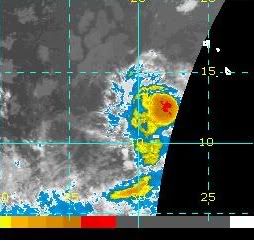
There is a closed low. See latest QuickSCAT pass... http://manati.orbit.nesdis.noaa.gov/storm_at_image21/qscat07081300_90as.png
Take care...
WW-911
| Storm Hunter |
| (Veteran Storm Chaser) |
| Mon Aug 13 2007 01:24 AM |
|
|
|
|
hmm... i think its very close to TD status now... if not already... the CDO is setting up nice.. and the cloud tops in the last few hours are pretty cold. Outflow looks good, banding becoming evident in the sats...... just a matter if NHC wants to pull the trigger and go ahead in call it a TD... or wait and see what the night holds for it... If they don't at the 11pm, and it holds through the night, i would expect morning crew to upgrade... And at this rate we could have a TS on our hands very soon... i don't see anything in the short term that would hinder it.... and yes its way out there in the atlantic... kinda susprising, but its been a few years since we see this in this area....look so good..... Watching the Navy now... I would assume Navy would go ahead with the upgrade to atleast TD?
Goes-east "Central Atlantic "
**Met-9 on NOAA is ever 6 hrs**
Some of the Quickscat flags show 25kts plus... so its seems its right there.
The reason i say NHC may hold... is in the 8:05pm TWD... they said that the low-level circulation is partially exposed... i am trying to find better sat shots... wonder what sat they are using?

"A 1008 MB LOW...ASSOCIATED WITH A VIGOROUS TROPICAL WAVE ALONG
25W S OF 18N...IS LOCATED OVER THE CAPE VERDE ISLANDS NEAR
12.5N25W. SATELLITE IMAGERY SHOWS THE LOW-LEVEL CIRCULATION
PARTIALLY EXPOSED TO THE NE OF A CONVECTIVE MASS. THIS SYSTEM
HAS IMPROVED IN ORGANIZATION OVER THE PAST 24 HOURS AND A
TROPICAL DEPRESSION COULD FORM LATER TONIGHT OR TOMORROW AS THE
LOW MOVES WESTWARD AT 15-20 KT. "
Atlantic Tropical Weather Discussion
| Random Chaos |
| (Weather Analyst) |
| Mon Aug 13 2007 01:52 AM |
|
|
|
|
This source seems to show the system within the past hour:
http://www-angler.larc.nasa.gov/cgi-bin/satimage/satImagery_big.cgi?domain=tisa_msg
Hard to tell much though given how small the image is, though.
| WeatherNut |
| (Weather Master) |
| Mon Aug 13 2007 02:01 AM |
|
|
I think the center has reformed under the new burst of convection. Looking at the last several frames of the WV loop it now has some banding features wrapping around where the center would have been. Its definitely looking more organized in the last 12hrs
| Old Sailor |
| (Storm Tracker) |
| Mon Aug 13 2007 02:05 AM |
|
|
|
|
Don't think 90L has made TD yet. tonight.
| Random Chaos |
| (Weather Analyst) |
| Mon Aug 13 2007 02:26 AM |
|
|
|
|
It did not.
The 1030pm NHC update still keeps it too disorganized to be a TD.
--RC
| Hugh |
| (Senior Storm Chaser) |
| Mon Aug 13 2007 02:38 AM |
|
|
Holy <pick your expletive>! I go out of town for the weekend, come back into town and see a blob out in the east Atlantic on the TWO, and come here and see MikeC's discussion, mentioning a name I do not care to hear: IVAN. On top of that, NRL appears to be down, and SSD does not have a floater on 90L yet.
Obviously the discussion of a long-range path for a system that has yet to organize into a depression is very premature, but... the computer models certainly paint what could ultimately turn into a very grim picture.
I've been away since Friday as I said so I don't know the genesis of this system, but looking at the graph based upon the realm of speculation, it looks like if it develops further east, it's more likely to go into the Gulf, whereas if it develops further west, it's more likely to be more north, and take aim at the eastern seaboard, or be a fish spinner. Is this the speculation, or am I misinterpreting the graph?
| cieldumort |
| (Moderator) |
| Mon Aug 13 2007 08:19 AM |

|
|
|
Just a couple of things to add
First, to my way of sizing systems up, 90L has been a tropical cyclone for the last 12 hours. NHC loves to go conservative on these puppies when they are well-out in the Atlantic with little, if any, data available to verify their suspicions. I do suspect we will have TD 4 up today, and probably as early as 5AM, baring some unforeseen major reversal of fortune for 90L.
Secondly, of note, an interesting little surface spinner, albeit a touch dry, around 10N 47W getting little mention anywhere, but might be worth keeping an eye on. It is that time of year. If it develops some deeper convection before running into the east Caribbean graveyard, I wouldn't be surprised to see it invest tagged.
Closer to home at the moment, if no further development comes of the mess in the western and central Caribbean, someone or someones is/are still likely to get a slug or two of really juicy tropical moisture. Pressures are falling a touch down there, and waters are very warm, but primarily the upper air environment continues to be hostile. However, as NHC notes, that may slowly change over the next few days. There appears to be two regions where some surface cyclogenesis could occur in there.
Lastly, another rather impressive wave is rolling off Africa right behind 90L.
All things considered, it wouldn't hurt to have Flossie scurry off to the south of the islands so that flights can be ready to go here, as well. Count 'em - four features probably worth monitoring now.
| madmumbler |
| (Storm Tracker) |
| Mon Aug 13 2007 11:43 AM |

|
|
|
Is anyone else having trouble accessing the NRL site? I haven't been able to get on since Fri./Saturday. It will say Loading...and then after a few minutes just time out.
Is it due to site traffic because of Flossie, or is there an alternate url I can try?
Thanks,
| allan |
| (Weather Master) |
| Mon Aug 13 2007 12:45 PM |

|
|
|
Tropical Depression 4 has finally developed, take a look at the dvorack readings..
13/1145 UTC 11.8N 30.6W T2.0/2.0 90L -- Atlantic Ocean
They should upgrade 90L at 11 for sure. Everyones getting mad at the NHC on the wunderground blog but teh NHC did a smart thing, they waited to see if the blow up of storms persisted. 96L a moth ago may have reached TD status but did not last due to dry air and dust, that's why the NHC did not pull the trigger. Anyways, the storm should slow some and allow the convection to catch up with the COC. I think Dean should be on board later today or tonight. I absolutely agree with Accuweather meteorologist Henry Margusity, this storm is a Florida storm, just don't buy the GFS southern solution.
| Random Chaos |
| (Weather Analyst) |
| Mon Aug 13 2007 01:36 PM |
|
|
|
|
NRL is already reporting it as 04L.NONAME, so it has been upgraded. NHC just hasn't posted the update yet. (9:30a EDT)
Edit:
NRL just added 91L to it's list in the Gulf, just off the Yucatan. (10:15a EDT)