Ed Dunham
|
| (Former Meteorologist & CFHC Forum Moderator (Ed Passed Away on May 14, 2017)) |
| Sun Jul 20 2008 12:30 PM |
|
|
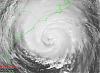
2AM EDT Update 21 July 2008
Dolly's center has been readjusted and it is now located over Cancun Mexico, which is a good shift (half a degree latitude) north from earlier center fixes. This means it will be over land only very briefly before moving into the Gulf of Mexico. Those in Texas and Northern Mexico need to watch Dolly very closely. 5AM forecast track may be adjusted.
Earlier Update
At 1545Z NHC upgraded Invest 94L directly to Tropical Storm Dolly in the western Caribbean Sea. Dolly is 230 miles southeast of Cozumel, Mexico moving to the northwest at 15 knots with sustained winds of 45mph and a central pressure of 1008MB. Tropical Storm Warnings are up for the east coast of the Yucatan peninsula.

Additional slow strengthening is anticipated before landfall Monday morning in the Cozumel area. The longer range NHC forecast places Dolly at the Texas/Mexican border near Brownsville on Thursday morning as a strong Tropical Storm. Those folks in the northern Mexico - Central and Southern Texas area need to monitor the progress of Dolly closely.
What do you think Dolly will do, the Dolly lounge is now open.
Tropical Storm Cristobal continues to drift slowly northeastward just off the North Carolina coast. Maximum sustained winds remain at 50mph and the central pressure is at 1007MB. Cristobal remained unchanged during the night, however some slight additional intensification is expected. Cristobal should remain just offshore as he heads toward Nova Scotia and gets absorbed by a trough moving off the east coast - in about four days.

Bertha is now extratropical as she races northeastward toward the southern shores of Iceland as a strong extratropical gale. The NHC issued its final bulletin on Bertha at 15Z.
A strong tropical wave will move off the coast of west Africa this evening and is worth monitoring for potential development next week.
ED
Event Related Links
Cozumel Weather
Cancun Radar Cancun Radar Loop (Flhurricane long term recording)
Long Term Radar Recording of TD#3 HCWX Level 3 Radar Recording/TD#3
Southeast Radar Composite (loop)
{{radarlink|jax|Jacksonville Radar}}
{{radarlink|mlb|Melbourne Radar}}
{{radarlink|clx|Charleston, SC Radar}}
{{radarlink|ltx|Wilmington, NC Radar}}
{{radarlink|mhx|Morehead City, NC Radar}}
{{radarlink|akq|Wakefield/ Norfolk/ VA Beach, VA Radar}}
{{StormCarib}}
{{StormLinks|Dolly|04|4|2008|2|Dolly}}
{{StormLinks|Cristobal|03|3|2008|4|Cristobal}}
{{StormLinks|Bertha|02|2|2008|1|Bertha}}
| typhoon_tip |
| (Meteorologist) |
| Sun Jul 20 2008 12:43 PM |
|
|
RE Cristobal: I mentioned this upon Cristobal's designation that nearby continental dry air mass may become a hindrance should Cristobal attempt to strengthen. NHC believes that to have been the case. In the earlier stages of this system's development, it's circulation field was not as expansive... But as that took place, the dry air at low and mid levels was ingested and that has prevented this system from sustaining deep convection.
John
|
danielw
|
| (Moderator) |
| Sun Jul 20 2008 12:51 PM |

|
|
|
Image below is the JSL enhancement. Notice the white fingers/ fringe around the periphery of Dolly.
This appears to indicate very little wind shear at the upper levels. Which could permit Dolly to strengthen rapidly.
Early morning, 12Z, upper air charts show an upper level high center over the GOM at 200mb or 38000 feet.

| typhoon_tip |
| (Meteorologist) |
| Sun Jul 20 2008 12:57 PM |
|
|
RE Dolly: There is a TUTT interfering with the deep layer wind profiles, causing some "denting" in an otherwise decent outflow. This is causing a bit of asymmetry in the cloud pattern, as well as preventing a uniform intensification. Until this feature finally disconnects from Dolly's outflow levels, this will likely prevent any period of more profound intensification. That, and Dolly's interaction with the Yucatan Peninsula will keep Dolly from becoming very strong. However, post clearing the peninsula, most large scale dynamical models predict an anticyclone over the BOC/western Gulf, and with amply warm waters in the Gulf there will be opportunity for more discerned development. Of course...none of this is intended to state that Dolly can't become stronger, just that the environment at this time suggests holding her own. Persons along the TX and Mexico coast certainly need to monitor the progress of this system.
| weatherguy08 |
| (Weather Hobbyist) |
| Sun Jul 20 2008 01:23 PM |
|
|
RE: Tropical Storm Dolly
Check this out: http://www.ssd.noaa.gov/goes/flt/t2/loop-wv.html
It looks like the center could be trying to relocate farther north. In the first advisory, the NHC had the center near 18.4, -82.2. In the loop, look around 20, -83.
| scottsvb |
| (Weather Master) |
| Sun Jul 20 2008 01:41 PM |
|
|
Your seeing a midlevel vortex from last nights blow up.....it happens every time a area of convection collapses...and this has happend about a dozen times during the last 5 days. LLC is still down by 18.7N and 84.6W
| cieldumort |
| (Moderator) |
| Sun Jul 20 2008 01:45 PM |

|
|
|
Quote:
Check this out: http://www.ssd.noaa.gov/goes/flt/t2/loop-wv.html
It looks like the center could be trying to relocate farther north. In the first advisory, the NHC had the center near 18.4, -82.2. In the loop, look around 20, -83.
I believe what you are picking up on is merely a lull in convective activity that has looped around some, as the ULL scoots off to the southwest, and as such, the fanning of those thunderstorms starts to come to an end, for now. The votice that is evident around 20N 83W is likely a decaying mid-level MCV that had been embedded in that previously mentioned, and now decaying, thunderstorm complex.
As a side note, using water vapor loops to determine where a surface circulation exists is not usually recommended. Water vapor images pick up on mid to upper level features, but almost always miss or mislead any activity that is at the surface.
| typhoon_tip |
| (Meteorologist) |
| Sun Jul 20 2008 01:57 PM |
|
|
Quote:
RE: Tropical Storm Dolly
Check this out: http://www.ssd.noaa.gov/goes/flt/t2/loop-wv.html
It looks like the center could be trying to relocate farther north. In the first advisory, the NHC had the center near 18.4, -82.2. In the loop, look around 20, -83.
Not really sure I'm seeing evidence of that given this particular product, but what this product is very proficient in demonstrating is the TUTT whirling across the Yucatan. There seems to be more torque energy to that feature than Dolly.
There's a couple of schools of thought on that.. One, if the TUTT continues to move off, it could actually excite an outflow channel along the western periphery of Dolly's upper levels... However, if Dolly continues to move WNW/NW in tandem with the TUTT's west displacement, then the net will be positive shear. It seems when looking at the deeper layer, at least for time being, the latter is taking place. But the situation obviously is continuously evolving so who knows where we will be with this overall construct 12 hours from now.
Having said all that...none of it really matters much until the interaction of Dolly with Yucatan can be accurately assessed. If Dolly does indeed pass over the land mass, what are we talking about then. Kind of makes much of this moot at that point

| Random Chaos |
| (Weather Analyst) |
| Sun Jul 20 2008 02:31 PM |

|
|
|
Watching IR and VW loops, you can see a lot of convection firing up SE of the old strong convective core. I think I'm starting to understand this system a bit more than earlier today.
What it seems we have is a very broad, very diffuse system that, due to it's size, is taking a lot of work to consolidate.
Think of past storms: the giant storms always take longer go gain strength and longer to dissipate. Compare that to tiny storms, such as Wilma or Andrew, that blew up from a TD to a Category 5 in a matter of a couple days.
As Dolly is so large, it's going to have a bear of a time getting organized enough to strengthen. but once it does, it's going to take a lot to slow it down (aka interaction with land).
I think the real questions is going to be weather she misses the Yucatan or not. The steering currents are heading mostly westward around tip of Cuba, which should pull her into the Yucatan even if she does try and thread the needle, assuming the steering currents don't change. Given how the shear changed over the past 24 hours, I don't put anything past the winds down there.
For reference, came across this site with a radar loop from western Cuba. It shows the outer bands of Dolly: http://www.cancunweathertoday.com/radar.php
| Hugh |
| (Senior Storm Chaser) |
| Sun Jul 20 2008 02:45 PM |
|
|
I agree that it appears to be an extremely broad LLC. As far as the tiny vs. large storms goes, Wilma was HUGE I believe - http://en.wikipedia.org/wiki/Image:HurricaneWilma20Oct2005.jpg shows a satellite image of Wilma at its peak intensity (185+mph). Not small by my definition.
As far as Andrew... it took 10 years for it to reach Cat 5 intensity (posthumously)! LOL
I agree that it's far too early to say whether Dolly misses the Yucatan, or where it goes from there regardless of if it misses or not. My own thinking is that the LLC will just make it through the Yucatan Channel, remaining mostly over water, but it wouldn't surprise me if it crossed land.
| Random Chaos |
| (Weather Analyst) |
| Sun Jul 20 2008 02:50 PM |
|
|
|
|
A very different view of Dolly, courtesy of CMISS's advanced dvorak technique site. It really shows off CoC and how the convection is placed in relation to it.

| Storm Hunter |
| (Veteran Storm Chaser) |
| Sun Jul 20 2008 03:32 PM |

|
|
|
good to see a lot of recon planes up... NOAA9 and two AF planes! Gulfstream IV-SP (G-IV) (Reg. Num. N49RF)
aka... Gonza is flying just south of Cuba
Air Force Aircraft (Last 3 digits of the tail number are 308) is almost due east of Myrtle beach, SC.. flying southeast
| WeatherNut |
| (Weather Master) |
| Sun Jul 20 2008 05:35 PM |
|
|
Is it possible that this latest burst of convection east of the LLC could pull the LLC underneath it? It looks as if the centers are trying to become vertically aligned. Looking at the last 2 or 3 frames on the visible sat. the low level swirl that was barely evident before under the convection seems to be pulled underneath this latest burst
| ftlaudbob |
| (Storm Chaser) |
| Sun Jul 20 2008 05:55 PM |
|
|
|
|
Quote:
Is it possible that this latest burst of convection east of the LLC could pull the LLC underneath it? It looks as if the centers are trying to become vertically aligned. Looking at the last 2 or 3 frames on the visible sat. the low level swirl that was barely evident before under the convection seems to be pulled underneath this latest burst
I am watching that also.That is an impressive burst,I hope that doesn't mean she is getting stronger,need to do some more research.Maybe someone can chime in on that.
| metwannabe |
| (Weather Hobbyist) |
| Sun Jul 20 2008 05:56 PM |

|
|
|
water vapor loop shows a "surge" of moisture northwestard from Yucatan Channel towards southern tip of La. Could this be some indication of a continued movement to the NW? If so, it sure looks like the center would have to make a westward jog to actually cross land tonight.
|
MikeC
|
| (Admin) |
| Sun Jul 20 2008 06:05 PM |
|
|
Quote:
water vapor loop shows a "surge" of moisture northwestard from Yucatan Channel towards southern tip of La. Could this be some indication of a continued movement to the NW? If so, it sure looks like the center would have to make a westward jog to actually cross land tonight.
This is a danger with the system not really as full developed as it should be. 94L has been "almost forming" for about a week now, and now that it seemingly has its still having some of that old behavior. I believe it will go pretty much on track for the next 24 hours or so, the suspense moment this evening is if something wild like forming closer to the Mid-Level Circulation, which more convection is firing at right now. Since recon really didn't get a good handle on the track, watching this closely in the evening will be interesting.
That said the entire cone needs to be watching this one. I dislike storms that haven't completely formed less than fully developed ones because it's a bit of a wildcard for track forecasting in certain situations, and this is one of them. Last year was the land of westward ho for these Caribbean storms, this year I'm not wagering on a repeat.
However, the ridge to the north should keep it from moving too far to the north, so I think the Hurricane Center's forecast is pretty reasonable.
|
MikeC
|
| (Admin) |
| Sun Jul 20 2008 06:15 PM |
|
|
I'm now recording a long term loop of Cancun's radar Cancun Radar Loop (Flhurricane long term recording)
| WeatherNut |
| (Weather Master) |
| Sun Jul 20 2008 06:21 PM |
|
|
Have been checking recon on google earth and the lowest pressure thus far has been 1006 millibars at 20.6 86.35 which might indicate the LLC is shifting a bit more north. Also a pressure of 1006.7 at 19.9/ 86.15 with pressures rising as the plane heads south
| Random Chaos |
| (Weather Analyst) |
| Sun Jul 20 2008 06:21 PM |
|
|
|
|
I think there are several confusing things about forecasting the track of the storm. The first is the water vapor and IR loops. If you take a look at the region WV loop, you can see that the burst of convection near the core has actually started rotating about the core, and has flipped from earlier today being aligned more toward the SW quadrant to moving almost to the E quadrant. Further, this rotation does not align with the surface fixes by recon, which were on the SW edge of this convection back when the convection was on the SW quadrant of its rotational axis. In addition to the latest convection burst, what appeared this morning to be the principle convective burst over Grand Cayman died down and has begun wrapping itself around the CoC under the more recent convective burst. This makes following any track on IR/Water Vapor almost impossible right now.
Second, the steering winds (via CMISS) are continually pointing westward, and even slightly WSW, not at all the direction the system is (or has been) moving. That this storm seems to be paying less attention to steering currents than normal makes forecasting potential tracks extremely unpredictable.
Therefore, I'd not focus too much on any particular track. Once Dolly gets her act together with a strong core and easily identifiable core, we should have a much better handle on where its headed.
| Storm Hunter |
| (Veteran Storm Chaser) |
| Sun Jul 20 2008 06:46 PM |
| Attachment |
|
|
|
|
just a side note.. recon has just passed through Dolly
see image attached
Something i find interesting... i think this was the first time... NOAA49 actually passed really close to the CoC on dolly during its mission earlier this afternoon... when i talked to a Flight Dir. for Kermit.... they FAA was giving approval for the new doppler on the tail of the Gonzo back in the spring while it was out in Oklahoma for installation.... and based on data sets from the flight.. they dropped an GPS Dropsonde within 75 miles of the center...

|
danielw
|
| (Moderator) |
| Sun Jul 20 2008 07:06 PM |
|
|
|
|
Cutouts from the NHC 200mb- 38000 foot level winds.
Left photo is 18Z @pm EDT Today and right photo is 6 hours earlier.
Quite a few changes in 6 hours.

| LoisCane |
| (Veteran Storm Chaser) |
| Sun Jul 20 2008 07:45 PM |

|
|
|
Explain the flight level wind maps for all of us please...
Note they are getting tons of data, especially from the JET so tomorrow's models (or late tonight?) should be the best yet.
A real consolidation around a center is going on. Shape is rounder, signs of outflow and if you cover the ULL on your screen and just look at Dolly (the ULL is distracting) you get a real feel for where she is at.
http://www.ssd.noaa.gov/goes/flt/t2/loop-vis.html
Great radar, this loop is good... you can see blow ups.
Looking forward to more accuracy in the 11pm discussion and advisory.
| craigm |
| (Storm Tracker) |
| Sun Jul 20 2008 07:52 PM |
| Attachment |

|
|
|
When in doubt break the 85ghz out. See attached file Excuse me - in this case it was 89 ghz - more complete pass
What I see here peering through the crap is possibly two areas that could consolidate as the center. The first one is around 20.2N;82.5W the other at 20N; 80W Dark blues are low clouds that return lower brightness temps that you would expect at or near the center of a storm - no water particles to reflect.. Similar spectrum as land. This image is 5 hours old. The fix at 5:00 Pm was 18.9N 85.0 west. So I'm placing the center N and E of that fix.
| okihabu |
| (Verified CFHC User) |
| Sun Jul 20 2008 09:19 PM |

|
|
|
I agree with you craig, I just looked at the radar again and it kinda reminds me what charlie did in 04. Dolly looks like she jumped right a little. If that high stays in the north middle of the gulf then its either a hard left or hard right. The northern most bands sorta go N then E. Charley made me leave thats why I say she jumps right.
| LoisCane |
| (Veteran Storm Chaser) |
| Sun Jul 20 2008 09:31 PM |
|
|
|
|
Interesting loop. Dark spot forming in the middle of the pink... would laugh it off but it's in dead center of the strongest convection.
http://metofis.rsmas.miami.edu/~dortt/satellite/Gulf/IR/atl_ir1_loop.gif
This storm took no time ramping up when the ULL weakened and makes me wonder what it will do over warm water in the GOM and think it will just nick the tip of the Yucatan at this rate though not sure... can't wait til 11 to read discussion and get some clarity on what is really going on.
note you can see the high aloft in the GOM on a few of the floaters now
|
Ed Dunham
|
| (Former Meteorologist & CFHC Forum Moderator (Ed Passed Away on May 14, 2017)) |
| Sun Jul 20 2008 09:41 PM |
|
|
There is no need to get folks alarmed at this juncture. In 2004 the synoptic situation was quite different. An unusually strong late season cold front and upper trough was plowing through the eastern Gulf of Mexico. That was the mechanism that captured Charley and turned it to the northeast. No such pattern exists tonight and no hard turns in either direction are either likely or anticipated.
ED
| craigm |
| (Storm Tracker) |
| Sun Jul 20 2008 09:48 PM |
|
|
|
|
Quote:
I agree with you craig, I just looked at the radar again and it kinda reminds me what charlie did in 04. Dolly looks like she jumped right a little. If that high stays in the north middle of the gulf then its either a hard left or hard right. The northern most bands sorta go N then E. Charley made me leave thats why I say she jumps right.
So far we have model consensus although the tropical suite is trending northward-- this of course can change. Trust the 3 day cone unless you know about some synoptic bomb that these super computers don't. NHC has a great track record - excuse the pun. Intensity though is a different story. I would definately be dusting my shutters off in Texas.
| Brett Addison |
| (Registered User) |
| Sun Jul 20 2008 10:05 PM |
|
|
Is it me or does it seem like the center of Dolly is heading NNW and further north then the 8:00pm advisory? Here is a link to the Cancun radar loop (I think the radar is actually stationed some where in Cuba):[url= http://www.cancunweathertoday.com/radar.php]Cancun radar loop[/url]
Here is a link to the Dvorák which I think shows the center further north and heading more north then forecasted: [url=http://www.ssd.noaa.gov/goes/flt/t2/loop-bd.html]Tropical Floater Two Dvorak[/url]
Any thoughts?
| weathernet |
| (Storm Tracker) |
| Sun Jul 20 2008 10:06 PM |
|
|
Actually Craig, I think that by the time you and others read this post, you might agree that rather than a "sucker hole", that a newly forming center may well be at 20.2N and 85.0W. My guess is that the low level center might be sliding under the CDO that has been persisting over the mid level center. Now that the ULL has filled some and certainly moved to the southwest, a significant alignment may be further improving. If in fact I am correct, on what may be a relocated position in the next package, I do not beleive this would be indicative of any major shift in forecast, but perhaps allow the models to better initialize current positon. I beleive the net result will be for an increase in battery and water shipments to the Texas coast, than what previously thought earlier today.
| Hugh |
| (Senior Storm Chaser) |
| Sun Jul 20 2008 10:11 PM |
|
|
I don't completely disagree with your logic, weathernet, but I don't agree with it either. I do believe the LLC has been aligning itself with the MLC under the CDO, and as a result, Dolly is going to strengthen fairly rapidly in the near term, I think. I don't think there's any significant net west movement going on with Dolly, though, right now. I think overall it's moving due north, with wobbles either direction of due north.
| weathernet |
| (Storm Tracker) |
| Sun Jul 20 2008 10:13 PM |
|
|
Brett, I think we posted at practically the same time. Though I took your link to check out the radar, is does not quite capture what most recent satellite does. I agree with you, in that the overall "appearance" is that of a system moving more NNW, than WNW. That said, I think we may be seeing what may be a newly consolodating center. To be sure though, one need see consistancy in at least a few more pictures. Of course a new recon pass would certainly do the trick too!
| Random Chaos |
| (Weather Analyst) |
| Sun Jul 20 2008 10:14 PM |
|
|
|
|
Weathernet, actually, that position makes sense based on Aircraft Recon.
Just under 2 hours ago, the center fix was 19°20'N 85°15'W. If it's moving NNW as it seems to be on IR and WV loops, that would put it pretty close to the 20.2N 85.0W that you mentioned, though I didn't calculate speed
.
| Hugh |
| (Senior Storm Chaser) |
| Sun Jul 20 2008 10:17 PM |
|
|
Quote:
Just under 2 hours ago, the center fix was 19°20'N 85°15'W. If it's moving NNW as it seems to be on IR and WV loops, that would put it pretty close to the 20.2N 85.0W that you mentioned, though I didn't calculate speed
But... NHC still says it's moving NW... is there still a plane in there tonight?
| weatherguy08 |
| (Weather Hobbyist) |
| Sun Jul 20 2008 10:20 PM |
|
|
Check out the new models. Basically, the farthest south of the early-cycle models, the GFNI, puts landfall 100 miles south of the US-Mexico border as a 74-knot storm. The farthest north, the CLP5, puts landfall literally on Galveston Island. I think we are going to be dealing with a Texas landfall. The spread in the 00z early-cycle models is 350 miles, not too bad for three days out!

Couldn't attach the file (too big), so I uploaded it to my website:
http://www.jasonsweathercenter.com/images/00z-21%20early-cycle%20models.png
| Random Chaos |
| (Weather Analyst) |
| Sun Jul 20 2008 10:21 PM |
|
|
|
|
There is: N43RF a.k.a Miss Piggy. Linky
And recon center fixes, per SFWMD: Linky
Enjoy!
| weathernet |
| (Storm Tracker) |
| Sun Jul 20 2008 10:23 PM |
|
|
Michael ~~~ Hmmm, thats very interesting. I did not know that they had come up with that fix a couple hours ago. With regards to factoring motion, that would seem to indicate practically minimal motion ( at least for the last couple of hours ). Not that I think that the forecast reasoning has changed much on overall forward motion, but if in fact this is the new center that we are seeing, and that Dolly may be really getting its act together this evening, that such a deepening trend might explain little or no motion. As we have noticed on numerous occassions over past history, many a storm undergoing deepening will tend to slow down or even stall temporarily.
If this is truly occuring, than I think we will soon see a WNW to NW resuming of forecasted forward motion, but with a new package adjusting the longer range path accordingly.
| Random Chaos |
| (Weather Analyst) |
| Sun Jul 20 2008 10:28 PM |
|
|
|
|
Actually, there is motion.
Recall that 1 degree at the equator is 60nm. Therefore, the distance required to take it from the recon fix the the center you estimated (45' W, 40' N) would be 60nm in two hours; that's 30nm/hr, or quite a bit faster than recon has seen it been moving. Although it's possible the center "skipped" under the convective core instead of actually moving normally.
Remember, these are all hypothetical positions, there is no recon data or anything official stating that it's at the position we're talking about. We only know the origin from recon, not it's present position.
(These estimates were done in my head, so don't quote me!)
|
Ed Dunham
|
| (Former Meteorologist & CFHC Forum Moderator (Ed Passed Away on May 14, 2017)) |
| Sun Jul 20 2008 10:38 PM |
|
|
It indeed does look like a center relocation is taking place. Winds at Cozumel are out of the east northeast and rather light - perhaps influenced by the remnant low level center now well to the west southwest of the reforming center. The SLP at Cozumel has leveled off over the past four hours. A small but well defined CDO appears to be forming over the earlier mid-level vortex. At 02Z I can roughly place a center at 20.7N 85.1W that is moving slowly to the northwest toward the Yucatan channel - around the northeastern perimeter of the upper level low to the southwest - but I've been fooled before by developing systems - particularly in this area. Sure seems like a stronger system with a northward position adjustment is in order.
ED
| Hugh |
| (Senior Storm Chaser) |
| Sun Jul 20 2008 10:42 PM |
|
|
Hey Ed... we've seen it before, so I have to ask... is it possible that what we're seeing is a period of potentially rapid intensification? Dolly has appeared to develop a pinhole eye on and off this evening, which for a 45mph tropical storm, is unheard of to my knowledge.
| Freezey |
| (Verified CFHC User) |
| Sun Jul 20 2008 10:43 PM |
|
|
earlier I had seen someone mention the high could possibly weaken. If so when and how much of an effect would it exactly have of Dolly?
| Random Chaos |
| (Weather Analyst) |
| Sun Jul 20 2008 10:43 PM |
| Attachment |
|
|
|
|
Following off of Weathernet and Ed's posts:
Take a look at the Dvorak plot (see attached). We've got the classic comma shape to that central convective zone now. But more interesting is that ring of very deep around a slightly lesser convection. Anyone else think the CoC is relocating there?
| Beaumont, TX |
| (Storm Tracker) |
| Sun Jul 20 2008 10:44 PM |
|
|
I don't think most of us have shutters here in Texas. But we are keeping an eye on Dolly. I do not think a Texas landfall down the road can
be ruled out. Depending on how Dolly fairs over the Yucatan and how much she strengthens in the Gulf, lots of factors at play here.
| LoisCane |
| (Veteran Storm Chaser) |
| Sun Jul 20 2008 10:46 PM |
|
|
|
|
http://www.ssd.noaa.gov/goes/east/carb/loop-wv.html
If you look at the WV loop (or any loop right now) you will see Dolly pulse up and intensify at the same time that Cristobal seems to have and even a weak Cristobal can influence Dolly some if the ULL has died out and the high... not sure on the high but on any loop... floater or carib or gom you can see an eye like, center like.. forming.
Not sure what the NHC will do cause you can't just up it 5mph and be conservative if an eye like feature (eye LIKE) which would imply Dolly is rapidly intensifying.
And.. timing is off here and whenever you are off on timing you are often also off on intensity forecasting.
| weathernet |
| (Storm Tracker) |
| Sun Jul 20 2008 10:48 PM |
|
|
Ed - Just to piggyback on the surface data you just stated, one of my favorite sites for satellite is Nasa's, in which i'll attach the link. Looking at the 2:15 pic, but moreso the recent loop, there seems little doubt to me that what appears as an eye is forming, and that in the short term it is indeed appearing to be moving NNWward.
Let see if this works.....http://weather.msfc.nasa.gov/GOES/
I like this link a lot because one can not only choose whether one wishes to view a loop, but permits one to "zero in", click, and get REALLY close. Several use options are available, including a short to quite a long loop option.
As a quite thought, regarding Dolly and Bertha....., and Cristobal...., does anyone have the date which might indicate the last year ( and how many years since such data was collected ), that we had 3 named active storms occuring at the same time, but specifically in the month of July?? Would appreciated the feedback
| Hugh |
| (Senior Storm Chaser) |
| Sun Jul 20 2008 10:50 PM |
|
|
Eye-like features can be deceptive, so the NHC is likely to be very conservative so as to not send shockwaves throughout everywhere. Yeah, honestly, it looks like a hurricane, but unless they have VERY concrete evidence to say it IS a hurricane, they won't increase the winds above 60mph I don't think.
| LoisCane |
| (Veteran Storm Chaser) |
| Sun Jul 20 2008 10:58 PM |
|
|
|
|
How bout little tail like features:
http://www.ssd.noaa.gov/goes/flt/t2/avn-l.jpg
Possibly Cristobal is tugging at her as he starts to head off to the NE... and then she will move more NW like again?
Seen this feature for a while on a few views...
WV has a few band like features forming
http://www.ssd.noaa.gov/goes/east/carb/loop-wv.html
|
Ed Dunham
|
| (Former Meteorologist & CFHC Forum Moderator (Ed Passed Away on May 14, 2017)) |
| Sun Jul 20 2008 11:00 PM |
|
|
The NASA site at Marshall is excellent - I've used it for years - and I did note the eyelike feature, but refrained from mentioning it - for the moment (I too need a little more data). Regarding the July question, see the latest Met Blog and check those years against the UNISYS database. Remember that we don't officially have three storms going at once since Bertha is now extratropical.
ED
| Random Chaos |
| (Weather Analyst) |
| Sun Jul 20 2008 11:03 PM |
|
|
|
|
Speaking of July records, NHC has included the wave still over Africa in their Tropical Weather Outlook with a medium chance of development. When was the last time we saw a TWO about a wave that hadn't even left Africa yet?
(sorry for the somewhat off topic...)
NHC is having a time with Dolly. Latest discussion says "it may not still be a TS due to lack of a closed low." And clearly if you relocate a closed low under that main convective zone, Dvorak pops up with a high end TS. Hmm. Going to be interesting.
|
Ed Dunham
|
| (Former Meteorologist & CFHC Forum Moderator (Ed Passed Away on May 14, 2017)) |
| Sun Jul 20 2008 11:08 PM |
|
|
Its not off-topic. I mentioned this wave in the leadoff article for this thread.
Regarding the latest NHC bulletin, they seem to cover the bases well and given the shear in the area, I'm not sure that I wouldn't have taken the same approach:
"THE INTENSITY
FORECAST ASSUMES THAT THERE WILL BE SOME DISRUPTION OF THE SYSTEM
OVER THE YUCATAN...WHICH COULD BE AVOIDED IF A CENTER REFORMS TO
THE NORTH WITHIN THE DEEP CONVECTION."
ED
| LoisCane |
| (Veteran Storm Chaser) |
| Sun Jul 20 2008 11:12 PM |
|
|
|
|
Listen wouldn't want to have to write the 11pm but think it's too conservative and direction is "forecasted" not consistent with current movement but this is the way they work. Forecasted means they expect it to move to the NW even if they see it looks a bit more NWN thus the phrase forecasted movement.
Imagine the biggest problem is going with what you see vs what was forecasted.
One of those storms where you see with your eyes something other than the official track (much like Irene in a way but not saying this is anything like Irene) where you have a weather mass moving on sats in a different direction from where the NHC says the center is..
Imagine they will be watching models over the next several hours carefully.
A lot I could say but I'm going to wait and see in the morning.
| Hugh |
| (Senior Storm Chaser) |
| Sun Jul 20 2008 11:16 PM |
|
|
Quote:
Listen wouldn't want to have to write the 11pm but think it's too conservative and direction is "forecasted" not consistent with current movement but this is the way they work. Forecasted means they expect it to move to the NW even if they see it looks a bit more NWN thus the phrase forecasted movement.
It's also too based upon things that just do not seem to be the case anymore. I agree that I would not want to have to write it, but they could have done a more thorough job of explaining what was really going on, particularly in the discussion.
| LDH892 |
| (Meteorologist) |
| Sun Jul 20 2008 11:42 PM |
|
|
|
I agree with the posts about the recent track of Dolly, being more north-northwestward than pure northwestward, and the fact that NHC didn't modify their 11pm forecast for the difference in initial position. It appears from the IR loop that Dolly is at ~20.5N, 85W, off a bit from the 11pm initial coordinates of 19.6N, 85.8N. Franklin did state that... "IF A CENTER REFORMS TO THE NORTH WITHIN THE DEEP CONVECTION"... the intensity forecast could be off if Dolly misses the Yucatan, so the hurricane specialist have noticed the recent change in motion/change in location of the low-level circulation center. As we all see, forcing consistency between forecasts sometimes produces errors. Observations should trump model output, but when the observed phenomenon is also highly erratic, errors are bound to occur. If Dolly continues to strengthen the next several model runs will become more realistic as they get a better handle on what Dolly is up to. Those interests in TX should keep a close eye on Ms. Dolly.
| metwannabe |
| (Weather Hobbyist) |
| Sun Jul 20 2008 11:42 PM |
|
|
|
|
I had mentioned early tonight that on WV Sat loop you could see a "surge" of moisture northwestard or a bulge if you will, towards the northwest GOM and I thought this would indicate the direction that Dolly would move, at least in the short term. I can still see this on the most recent WV Loop and it certainly appears that most posting here believe she is moving in a NNW/NW direction. Without a definite center pos. it is difficult to be sure but I just do not see the LLC passing over land tonight. In fact I would not be surprised if later a center is fixed further north and we see a dramatic shift in model runs.
Systems that look this good on sat but still developing...not only frustrating, but can be down right scary for anyone that lives around GOM!
| Storm Hunter |
| (Veteran Storm Chaser) |
| Sun Jul 20 2008 11:52 PM |
|
|
|
|
agree with a few others on here... i think... and this is based on cancun radar and sats (if you look at the loop in the last few hrs.. looks like the center may have reformed just ne of cozumel, MX... cuz the radar data is low there.. closer to the radar scan)..... putting cancun under the gun more... my thought was the farther north away from the affects of the ULL to the west would be a better chance of getting its act together... from the surface to upper levels... which would let the convection blossom more and spiral out... giving it a shot at forming a better structure.... plus dolly is in the southern part of the loop current.. so the fuel is there... i just think the conditions in the SW GOM will support a strong system, once it clears the yucatan in the morning...
**side note.. AF Recon is over Charleston, SC at 24kft headed to Cristobal** I think Cristobal finally hit the Gulf Stream this evening
| typhoon_tip |
| (Meteorologist) |
| Mon Jul 21 2008 12:20 AM |
|
|
Quote:
It indeed does look like a center relocation is taking place. Winds at Cozumel are out of the east northeast and rather light - perhaps influenced by the remnant low level center now well to the west southwest of the reforming center. The SLP at Cozumel has leveled off over the past four hours. A small but well defined CDO appears to be forming over the earlier mid-level vortex. At 02Z I can roughly place a center at 20.7N 85.1W that is moving slowly to the northwest toward the Yucatan channel - around the northeastern perimeter of the upper level low to the southwest - but I've been fooled before by developing systems - particularly in this area. Sure seems like a stronger system with a northward position adjustment is in order.
ED
Yes! I definitely agree with this post. I was just about to post regarding the subject matter and pinged this just in time!
| typhoon_tip |
| (Meteorologist) |
| Mon Jul 21 2008 12:22 AM |
|
|
Quote:
agree with a few others on here... i think... and this is based on cancun radar and sats (if you look at the loop in the last few hrs.. looks like the center may have reformed just ne of cozumel, MX... cuz the radar data is low there.. closer to the radar scan)..... putting cancun under the gun more... my thought was the farther north away from the affects of the ULL to the west would be a better chance of getting its act together... from the surface to upper levels... which would let the convection blossom more and spiral out... giving it a shot at forming a better structure.... plus dolly is in the southern part of the loop current.. so the fuel is there... i just think the conditions in the SW GOM will support a strong system, once it clears the yucatan in the morning...
**side note.. AF Recon is over Charleston, SC at 24kft headed to Cristobal** I think Cristobal finally hit the Gulf Stream this evening
It seems we have a slightly vertically tilted system. The mid-level circulation is even somewhat more NE of the low level "apparent" relocation. It makes sense that this would take place given to the shear imparted by the TUTT pulling west.
| Storm Hunter |
| (Veteran Storm Chaser) |
| Mon Jul 21 2008 12:29 AM |
| Attachment |
|
|
|
|
oh yeah.. guess i should of mentioned i was checking the obs there at the surface... in Cancun, Cozumel, and the bouys.. and was coming up with my estimate on dolly. I would think if what is happening is true, then dolly could be making landfall in a few hrs?
Recon is just south of morehead city, descending in alt. down to 15kft from 24kft... i very interested to see what they find in cristobal
UPDATE... there 20 miles se of Cape Lookout at 5kft and already have 35mph winds.. inbound to center
Please check your aircraft altitudes. 5 feet is below minimums.~danielw
CORRECTED.. to 1,579 meters....
sorry
| scottsvb |
| (Weather Master) |
| Mon Jul 21 2008 12:36 AM |
|
|
I would think its about to make landfall in the next hour or 2...its just E of Cancun and SW of the main area of convection (but catching up to it and the midlevel support)...thus very minimal land interaction will take place as its been moving more NNW due to the upper low sliding S. This has a chance to become a hurricane later tonight (monday night) into Tuesday morning as condition will be just about perfect for development.
| Storm Hunter |
| (Veteran Storm Chaser) |
| Mon Jul 21 2008 12:40 AM |
|
|
|
|
agree with ya there scott on Dolly
i just spent the last half hour looking at cristobal... and i think we have the samething going on with it too... i'm watching the recon flight... and looking at ground nexrad from Morehead City... i think we have two centers... a weaker surface center and a stronger mid level center on this system.
this might help show what i'm talking about
|
MikeC
|
| (Admin) |
| Mon Jul 21 2008 01:01 AM |
|
|
Staring at a few satellite images and the Cancun radar loop (swing mode), it certainly appears like it's just going to clip the northern tip of the Yucatan just on the north side of Cancun. It may be an interesting morning if that proves out.
| scottsvb |
| (Weather Master) |
| Mon Jul 21 2008 01:03 AM |
|
|
The NHC uses previous fixes as the movement...for example... lets say its moving N but by 2am its moving NW....well the NHC will post up movement N at such and such miles per hour from the last statement. So another words...its the previous 3 or 6 hrs (matters on when the last statement was released) on its movement.
Charley was moving NNW from the 8am-11am (although we saw a wobble to the NE (which it was actually a turn NE) they trackulated the point from 8am-11am it was a NNW movment even though it already started a NE turn.
| Storm Hunter |
| (Veteran Storm Chaser) |
| Mon Jul 21 2008 01:45 AM |
| Attachment |
|
|
|
|
well recon found the surface center on cristobal and a pressure of 1005mb... but strongest winds were 85 miles to the sw of center... recon hasn't hit the mid-upper low to the se of the center
Observation Number: 05
A. Time of Center Fix: 21st day of the month at 5:09:50Z
B. Center Fix Coordinates: 35°29'N 74°38'W (35.48N 74.63W)
B. Center Fix Location: 53 miles (85 km) to the ENE (73°) from Cape Hatteras, NC, USA.
C. Minimum Height at Standard Level: 1,461m (4,793ft) at 850mb
D. Estimated (by SFMR or visually) Maximum Surface Wind: 26kts (~ 29.9mph)
it took the radiosonde about 2 mins from 5,000ft to hit the water at 0512z... winds at 157ft were 12mph in the center.
|
danielw
|
| (Moderator) |
| Mon Jul 21 2008 02:04 AM |
|
|
|
|
Watch the north and westward advance of the outer cloud bands from 94L / Dolly.
1245Z 845am EDT Sunday

2245z-645PM EDT Sunday

0415Z-1215AM EDT Monday

| Storm Hunter |
| (Veteran Storm Chaser) |
| Mon Jul 21 2008 02:11 AM |
|
|
|
|
anyone see the TWO that just came out? wow
THE National Hurricane Center IS ISSUING ADVISORIES ON TROPICAL
STORM CRISTOBAL...CENTERED ABOUT 30 MILES EAST OF CAPE
HATTERAS NORTH CAROLINA...AND ON TROPICAL STORM DOLLY...LOCATED
NEAR CANCUN MEXICO. (seems like someone is on the same idea as us..
)A VIGOROUS AND WELL-DEFINED TROPICAL WAVE IS LOCATED OVER WESTERN
AFRICA A COUPLE HUNDRED MILES EAST OF DAKAR SENEGAL. THIS SYSTEM
HAS THE POTENTIAL TO BECOME A TROPICAL CYCLONE VERY QUICKLY AFTER
IT EMERGES INTO THE EASTERN ATLANTIC WITHIN THE NEXT DAY OR TWO.
by the way... got to the main page on the NHC and look at africa.. its already in shaded in orange.. lol
| Storm Hunter |
| (Veteran Storm Chaser) |
| Mon Jul 21 2008 02:16 AM |
|
|
|
|
aww... here we go.. From Dolly's adv. 2am pkg
SATELLITE IMAGES...SURFACE OBSERVATIONS...AND RADAR DATA FROM CANCUN
MEXICO INDICATE THAT DOLLY LACKS A WELL-DEFINED CENTER OF
CIRCULATION AT THIS TIME. HOWEVER THERE ARE INDICATIONS THAT THE
CENTER IS REFORMING A LITTLE TO THE NORTH OF THE PREVIOUS TRACK.
| Beaumont, TX |
| (Storm Tracker) |
| Mon Jul 21 2008 02:20 AM |
|
|
Interesting to note the mention in the 2 that there are indications Dolly may be reforming the center a little to the north of the previous
track. If so, I think we will see a shift in the cone more to the right tomorrow. It will depend on what she does once she gets into the Gulf.
| ftlaudbob |
| (Storm Chaser) |
| Mon Jul 21 2008 02:22 AM |
|
|
|
|
Man,this is going to be a very bad year.Doily looks to be a real threat to anyone along the gulf coast mainly Texas.Warm sst's in the gulf along with low shear are not a good sign.This is just crazy for this time of year.I am almost speechless.
| scottsvb |
| (Weather Master) |
| Mon Jul 21 2008 02:30 AM |
|
|
Dolly will get pulled more WNW now that 1 its over land and wont strengthn much and also the upper low to its SSW....by time the upper low moves out and weakens...the ridge over the gulf states will weaken and let Dolly regain a NW movement towards NE MX and maybe extreme southern TX.
|
danielw
|
| (Moderator) |
| Mon Jul 21 2008 02:33 AM |
|
|
|
|
I hate to add to the mix of bad news but the Model Discussion is out. Here are the Dolly related excerpts.
Full text at: http://www.hpc.ncep.noaa.gov/html/discuss.shtml
http://www.hpc.ncep.noaa.gov/discussions/pmdhmd.html
MODEL DIAGNOSTIC DISCUSSION
NWS HYDROMETEOROLOGICAL PREDICTION CENTER CAMP SPRINGS MD
114 AM EDT MON JUL 21 2008
VALID JUL 21/0000 UTC THRU JUL 24/1200 UTC
...T.S. DOLLY...
AVAILABLE SFC DATA SUGGESTS THAT REGARDLESS OF WHETHER THERE IS A
CLOSED CIRCULATION... LOWEST SFC PRESSURES ARE LOWER THAN DEPICTED
IN THE GFS ANALYSIS.
MODEL TRENDS...
...T.S. DOLLY...
THE 00Z NAM TRACK IS SIMILAR TO THE 18Z RUN BUT THERE IS A
PRONOUNCED NWD TREND OVER THE PAST 12-24 HRS. THE 00Z NAM IS MUCH
STRONGER THAN PREVIOUS RUNS. ESPECIALLY IN THE PAST 12 HRS THE
GFS HAS TRENDED NWD WITH DOLLY THRU F36 EARLY TUE. AFTER THAT
TIME TRENDS DIMINISH TO THE POINT THAT GFS RUNS CONVERGE ALONG THE
WRN GULF COAST BY F60 EARLY WED... AND THEN THE 00Z GFS TRENDS A
LITTLE SWD OF MOST PREVIOUS RUNS.
MODEL DIFFERENCES AND PREFERENCES...
...T.S. DOLLY...
THE GFS/NAM SHOW SIMILAR HANDLING OF THE SYSTEM THRU F24 LATE MON.
AFTER THAT TIME THE NAM TRENDS STRONGER THAN THE GFS AND
EVENTUALLY FARTHER NWD AS WELL. ONCE THE SYSTEM REACHES THE WRN
GULF COAST THE NAM MAINTAINS A NWWD MOTION WHILE THE GFS KEEPS THE
SYSTEM OVER THE COAST. THE NAM TRACK IS ON THE NRN EDGE OF 18Z
GEFS ENSEMBLE MEMBERS BUT FITS MORE COMFORTABLY WITHIN THE SPREAD
OF 21Z SREF MEMBERS. THE UKMET/CANADIAN GLBL/12Z ECMWF ARE S OF
THE NAM TRACK TO VARYING DEGREES BY THE TIME THE SYSTEM REACHES
THE WRN GULF COAST. CONSULT LATEST TPC ADVISORIES AND DISCUSSIONS
FOR FURTHER INFO REGARDING T.S. DOLLY.
| Storm Hunter |
| (Veteran Storm Chaser) |
| Mon Jul 21 2008 02:39 AM |
|
|
|
|
well... going to be an interesting morning with the next crew of guys coming into the NHC office... wonder if they called the boss to let him know what's going on? and based on doppler trends.. i say that dolly would enter the GOM just north of Tizmin in 3-6 hrs... and that would most likely have to shift the forecast path to the right on Dolly in the short term...
Looks like will know in a few mins if Dolly made landfall or not.
http://weather.noaa.gov/weather/current/MMUN.html
| Hugh |
| (Senior Storm Chaser) |
| Mon Jul 21 2008 06:51 AM |
|
|
Morning satellite images (infrared since the sun is not up yet!) suggest that Dolly is now moving almost due west... if Dolly exists, that is. Radar from Cancun indicates that the big ball that is in the Yucatan Channel has no circulation, so if one exists, it's very disorganized.