Ed Dunham
|
| (Former Meteorologist & CFHC Forum Moderator (Ed Passed Away on May 14, 2017)) |
| Mon Aug 09 2010 11:22 PM |
|
|
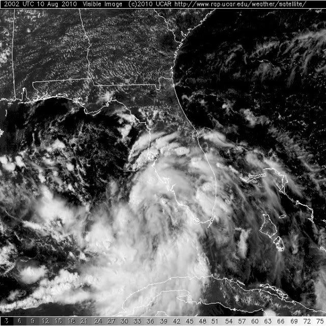
5 PM EDT Update 10 August 2010
The National Hurricane Center issued it's last advisory on Tropical Depression 5, it will just be a rain maker along the northern gulf coast.
A couple of other areas are worth watching, although they may not hold together. Tropical wave with active convection and slightly better organization located near 13.5N 58.5W at 11/21Z is moving west at about 15 knots. A convective flareup located southwest of Invest 93L near 23N 60W at 11/21Z is moving to the west northwest.
{{NortheastGulfRadar}}
{{NorthGulfRadar}}
{{StormLinks|Ex-TD#5|05|5|2010|1|Ex-TD#5}}
{{StormLinks|93L|93|6|2010|3|93L}}
6:30AM EDT Update 10 August 2010
Tropical Depression Five hasn't organized overnight, but may later today. Odds favor the system making landfall as a Tropical Storm in eastern Louisiana or Mississippi sometime overnight Thursday into Friday.
The system has pulled in quite a bit of dry air overnight and is even a bit weaker than yesterday currently, but can recover.
There is an outside chance that the system can strengthen beyond that, but unless it changes drastically today or tomorrow, it doesn't look like that will happen. If it does strengthen it would likely be just before landfall. Therefore those in the warning area will need to pay close attention to local media and officials. But, again, odds are It likely will be mostly a rain maker.
Also forward motion of the storm is forecast to slow down, perhaps dramatically, which could extend the system's time over the Gulf and perhaps landfall a bit east of that. If it slows down enough it may loop over land and wind up back over the gulf briefly.
If the track were to change it would more likely wind up more easterly than it is now.

The wave in the central Atlantic, (93L) still has a good chance to form, but has not yet, it would stay out to sea.
Another wave east of the Caribbean has a very low chance (10%) of developing in the short term, but will need to be watched if it persists.
8PM EDT Update 10 August 2010
Invest 94L has developed better structure and has been upgraded to Tropical Depression 5. The TD is forecast to move northwest with NHC initial landfall projection into the Louisiana delta Thursday morning as a 40 knot Tropical Storm.
A Tropical Storm Warning has been issued as follows:
"A TROPICAL STORM WARNING HAS BEEN ISSUED FOR THE NORTHERN GULF OF
MEXICO COAST FROM DESTIN FLORIDA TO INTRACOASTAL CITY
LOUISIANA...INCLUDING LAKE PONTCHARTRAIN AND NEW ORLEANS."
Residents along the northern Gulf coast should monitor the progress and development of this system.
ED
7PM EDT Update 10 August 2010
The area in the Gulf is likely to become the 5th tropical depression of the season tonight, best track has renumbered it to 5, and advisories may begin soon at 8PM EDT 7PM CDT, at latest by 11PM EDT.
Those in the northern Gulf of Mexico will want to watch the system in the southeastern Gulf.
7AM EDT Update 10 August 2010
This morning, the area in the Central Atlantic (93L) is still looking like it may develop, but it just hasn't yet. It will stay out to sea.

The area in the southeastern Gulf, (94L) is something that may develop during the week, those along the northern central and northwestern Gulf Coast will want to watch, the good news is dry air to the northwest is keeping the system down and weaker for the moment. Most likely it will hit land as a Tropical Storm, but the further westward it makes it the more time it would have to strengthen.
If that happens, then a strengthening tropical storm/cat one hurricane could be approaching the coast. So those in the northern Gulf must keep a close watch on this system. The timing would be on Friday.
Odds favor somewhere in Louisiana as a tropical Storm, around 50-60mph winds, possibly stronger if the system reforms a bit westward.
Original Update
Lots of little sparks of potential but the Atlantic is just too hostile for anything to get organized. Upper level shear has relaxed considerably in the Gulf, the Caribbean Sea and the Atlantic south of 20N, but low-level easterly shear is tearing apart tropical waves before they even leave the west coast of Africa.
Invest 94L off the southwest Florida coast near 26N 82.5W at 09/18Z and drifting to the west southwest. The system is poorly defined with convection displaced to the south. Only a modest chance for additional development, but because the area is close at hand it deserves some attention.
A very small feature is located in the central Caribbean Sea midway between Aruba and the Dominican Republic near 15N 70W at 09/22Z. The system has pulsating convection and is moving to the west northwest at 7 knots. Small systems are fragile and can get very strong or fall apart in a short period of time. The system remains in a favorable environment for development.
Invest 93L is in the central Atlantic near 23.7N 49.9W at 09/22Z and the system is moving southwest at about 5 knots. If it had developed it would have pulled off to the northwest, but the weak circulation has moved away from its limited convection well to the northeast of the center. The wave has encountered dry air and is very disorganized – if this system develops (and I’m not so sure that it will) its going to take quite awhile to do so.
Finally, a tropical wave southeast of the southern Cape Verde Islands is being consumed by the SAL. Lots of places to watch, but no immediate concerns.
ED
| Storm Hunter |
| (Veteran Storm Chaser) |
| Tue Aug 10 2010 02:17 AM |

|
|
|
18z GFDL exploded off of LA, just before landfall with 94L... GFDL 18z but that just doesn't seem likely at this moment... the big fly in forecast is the ULL of SE Florida. It appears that it will continue westnorthwest ward and be off LA in about 36-48hrs.... where 94L is at by then will determine how the system/low will do. One thing i see on the plus side for 94L is the slow movement in the SE GOM the next few days. The other is the very WARM GOM temps... its baking out there, and shouldn't take much to fire storms, but the shear will decide if the storms hold for the next few days. There is dry air over NE GOM, but that should fill in within a couple of day.
If we were tracking ULL's this year and last... we have a VERY active season... lol
| metwannabe |
| (Weather Hobbyist) |
| Tue Aug 10 2010 02:55 AM |

|
|
|
I was thinking the same thing about the ULL's, just look at them lined up across the Atlantic!
http://www.ssd.noaa.gov/goes/east/tatl/flash-wv.html
I just don't remember seeing the tropics get going when the atmosphere is as chaotic as it is now...93L is squeezed between 2 ULL's and is there any chance that 94L will ever completely seperate from that ULL over Fl.?
| berrywr |
| (Weather Analyst) |
| Tue Aug 10 2010 04:30 AM |

|
|
|
I'm looking at the 10/00Z package as we speak. Satellite imagery late this evening has a low developing on the old frontal boundary just to the SW of the current invest location. Atmosphere aloft is very light; however the fly in the ointment is the upper low to its east over the Bahamas and for the moment I don't agree with a movement into the NE GOM as discussions are saying, but as I just said I haven't looked at the package in detail and will comment shortly on this system in about an hour.
| berrywr |
| (Weather Analyst) |
| Tue Aug 10 2010 05:05 AM |
| Attachment |
|
|
|
|
Early good morning to all...I don't believe the organization with 94L is tropical at this time. The upper low off the coast of Melbourne, FL is dropping shortwave energy from north to south and filling the area of subsidence with moisture aloft to the north of the system. Current satellite imagery as of 10/05Z has the system beginning to develop SW of the earlier location of the Invest center of circulation.
Per NHC discussion there is the possibility in the short term of this system being a hybrid/subtropical system and I agree with this assessment has suppor from the upper level low will have a role in its development. This broad area of low pressure is not the same low that was near 27N 86W...it has dissipated as it moved south. This new area is located at 24N 84W and is sagging slowly south with steering currents currently aloft NNE to SSW.
Looking ahead at the upper level charts the upper level low to the system's east will ride along with the system to landfall which suggest we won't be dealing with an entirely tropical system. Initially the system will be a slow mover; perhaps near stationary for the first 24 to 36 hours and this will allow the ULL to phase with it aloft. 94L and the ULL are progged by the models to then move WNW across the GOM and a landfall on the upper TX/W LA coast late Thursday/early Friday this week.
Mid-Continental ridge remains over the Mid-South initially and retrogrades west to the 4 corners region with its axis extending east along the Mid-South and SE USA states with easterly flow aloft along the Gulf coast. There is another cutoff low extending from the progressive east coast long wave trough...inverting itself about 300 nm south of Bermuda and the Bermuda ridge east of it and not a player in the evolution of this system. Upper low continues to move north over TX into the central US and dissipating as it becomes elongated at this time.
courtesy of the NHC Glossary:
A subtropical cyclone is a non-frontal low pressure system that has characteristics of both tropical and extratropical cyclones. This system is typically an upper-level cold low with circulation extending to the surface layer and maximum sustained winds generally occurring at a radius of about 100 miles or more from the center. In comparison to tropical cyclones, such systems have a relatively broad zone of maximum winds that is located farther from the center, and typically have a less symmetric wind field and distribution of convection.
There is a wiki on subtropical cyclones and it has excellent information about these types of storms; it can be found at: http://en.wikipedia.org/wiki/Subtropical_cyclone
| JoshuaK |
| (Weather Guru) |
| Tue Aug 10 2010 02:50 PM |
|
|
Dry air continues to be our savior in regards to development of 94L. Its a little disconcerting, IMO, to see everything visible in the satellite loops rotating around 94L. The bigger belt of dry air over LA looks like it's being shoved away from 94L by the rotation, but the smaller area of dry air near the approx CoC looks to be entraining itself into the low pressure area. Don't get me wrong, I like the rain we're getting from this thing, but the size of system could make it a sheer mess if it forms into something significant, if from nothing than the flooding threat alone.
| MichaelA |
| (Weather Analyst) |
| Tue Aug 10 2010 04:21 PM |

|
|
|
The dry air looks to be moving off to the NW while the ULL near Cape Canaveral is now wrapping moisture around it. Winds are above normal from the SE and SSE here in West Central FL today. Based on the sat/radar presentation and general conditions, I'd say that 94L is spinning up today and tomorrow. Looks more like an Alabama/Mississippi landfall may be more of a probability to me. Also, the southern part of the wave that spawned 93L bears watching as it approaches the windward islands.
| WesnWylie |
| (Weather Guru) |
| Tue Aug 10 2010 04:46 PM |
|
|
I have a feeling the NHC will up the chance for development to 70% or 80% @ the 2:00 p.m. EDT update. 94L is certainly a large system in terms of how wide its "banding" extends. I have a feeling if the system continues organizing through the rest of the day, we will have tropical depression by tonight. I personally think a Louisiana landfall appears most likely at this time, but I could be wrong.
| hogrunr |
| (Weather Guru) |
| Tue Aug 10 2010 05:09 PM |

|
|
|
Wow...hadn't seen the wave approaching the Windward Islands...it looks pretty good. It will be interesting to see if the NHC marks it code anything at the 2pm EDT update.
|
danielw
|
| (Moderator) |
| Tue Aug 10 2010 05:13 PM |

|
|
|
RECON is nearly halfway to the INVEST point. Should be there within the hour. They adjusted the inbound leg to fly from SE Louisiana to 94L. Probably to gather upper air data, as most models are forecasting a track toward the Mouth of the Mississippi River and the Macondo Oil Spill site.
BP has just announced a STOP Drilling at the Macondo site. US Coast Guard requested the STOP and all vessels to port. This information is from TWC.
| RobM |
| (Registered User) |
| Tue Aug 10 2010 05:16 PM |
|
|
The Key West radar looks more and more defined with its COC and the developing bands around it. The radar images have burned me before but the latest GFDL run seems to substantiate the appearance of development. I'm beginning to wonder how the new timing protocals for warnings are going to work since the storm won't be developing until just before landfall.
| WeatherNut |
| (Weather Master) |
| Tue Aug 10 2010 05:21 PM |
|
|
I'm also beginning to see some banding wrapping around the north side. The ULL is bypassing it to the north moving on a westerly direction. The danger with this system is that if it gets organized it could ramp up quickly (thats IF not for sure). Conditions are forecast to only get more conducive. It definitely looks more tropical than yesterday
| WeatherNut |
| (Weather Master) |
| Tue Aug 10 2010 05:28 PM |
|
|
The area to the east of the leeward Islands is definitely becoming better organized. In the last couple of frames there looks to be some convection firing around what looks to be the center of the cyclonic turning. Might be something to watch, but so far this season things like this seem to have a hard time persisting.
| WesnWylie |
| (Weather Guru) |
| Tue Aug 10 2010 05:54 PM |
|
|
They've upped it to 70% and said that depending on what the RECON finds watches and/or warnings could be issued as early as this afternoon.
| Storm Hunter |
| (Veteran Storm Chaser) |
| Tue Aug 10 2010 05:57 PM |
|
|
|
|
last recon data i have put them less then 25 miles from 94L coming in from NW at about 1ft above surface... SMFR data shows winds on NW side of about 20-25mph at surface... flight level winds in the 20kts range... one interesting thing i'm seeing is at the air temp is about the upper 70's at 1kft, but the dewpoint is around 50F at a 1kt!
PS: The ULL is much further to the north then i thought it would be... so this appears now it will help return moisture over 94L in the coming hours and would help the outflow on the northern side of 94L... aka, an aid in development this time
| Storm Hunter |
| (Veteran Storm Chaser) |
| Tue Aug 10 2010 06:07 PM |
|
|
|
|
Recon made a pass on a circulation at....
Time: 17:51:00Z
Coordinates: 25.8167N 83.7833W
Acft. Static Air Press: 976.0 mb (~ 28.82 inHg)
Acft. Geopotential Hgt: 293 meters (~ 961 feet)
Extrap. Sfc. Press: 1009.2 mb (~ 29.80 inHg)
D-value: -
Flt. Lvl. Wind (30s): From 277° at 2 knots (From the W at ~ 2.3 mph)
Air Temp: 24.4°C (~ 75.9°F)
Dew Pt: 10.8°C (~ 51.4°F)
Peak (10s) Flt. Lvl. Wind: 4 knots (~ 4.6 mph)
SFMR Peak (10s) Sfc. Wind: -
SFMR Rain Rate: -
winds on the outbound are westerly and southerly and stronger... so it appears this would be the location of 94L... waiting on some more data... not too sure about being fully tropical?
| berrywr |
| (Weather Analyst) |
| Tue Aug 10 2010 06:26 PM |
|
|
|
|
ASCAT got an excellent look at the system earlier today and the CoC was located near 25N 84W with 15 winds in all quadrants except south where winds were near 25 knots in convective activity.
Water vapor satellite imagery has a considerable area of subsidence and dry air in advance of the ULL currently near the east coast of FL. Models continue to insist it will move west and west-northwest and poses the question of whether the system will be tropical or subtropical.
|
danielw
|
| (Moderator) |
| Tue Aug 10 2010 06:42 PM |
|
|
|
|
TROPICAL WEATHER OUTLOOK
NWS TPC/NATIONAL HURRICANE CENTER MIAMI FL
200 PM EDT TUE AUG 10 2010
FOR THE NORTH ATLANTIC...CARIBBEAN SEA AND THE GULF OF MEXICO...
A LOW PRESSURE SYSTEM LOCATED OVER THE SOUTHEASTERN GULF OF
MEXICO...ABOUT 100 MILES WEST OF SOUTHWEST COAST OF THE FLORIDA
PENINSULA...IS ACCOMPANIED BY A LARGE AREA OF SHOWERS AND SQUALLS.
SATELLITE IMAGES INDICATE THAT THERE HAS BEEN A GRADUAL INCREASE IN
ORGANIZATION TODAY. HOWEVER...THE ENVIRONMENT IS NOT IDEAL FOR
SIGNIFICANT DEVELOPMENT. AN AIR FORCE PLANE IS APPROACHING THE
SYSTEM AND WILL HELP TO DETERMINE IF A TROPICAL DEPRESSION IS
FORMING...AND IF SO...
WATCHES OR WARNINGS COULD BE REQUIRED FOR A PORTION OF THE NORTHERN GULF OF MEXICO COAST AS EARLY AS THIS
AFTERNOON. THERE IS A HIGH CHANCE...70 PERCENT...OF THIS SYSTEM
BECOMING A TROPICAL CYCLONE DURING THE NEXT 48 HOURS AS IT MOVES
WEST-NORTHWESTWARD AT 5 TO 10 MPH.
| MichaelA |
| (Weather Analyst) |
| Tue Aug 10 2010 06:45 PM |
|
|
|
|
A little dry air and subsidence has dampened convection near the probable center this afternoon, but banding is evident away from the center. If convection re-fires near the center, a TD will probably be declared. That is a low dew point at 1kFT, so this may not be entirely tropical yet. It does look like it is either stationary or drifting northward on both sat pics and radar, though.
| berrywr |
| (Weather Analyst) |
| Tue Aug 10 2010 07:06 PM |
|
|
|
|
The outflow you're observing to the northeast is the ULL currently at the Central FL east coast. I grant you it appears obscured at best but it is the ULL and all models have it travelling over the top of 94L. You may have text bulletins saying conditions are not ideal despite low shear and warm water. This system was originally part of an old frontal boundary and observing water vapor imagery there are shortwaves rotation cyclonically around the upper low and as you noted there is considerable subsidence and dry air that continues to be pushed south and southwest and if models verify 94L is likely to impaired by entraining this air into it. Tropical, Subtropical I don't concern myself with except they do technically differ in regards to how they are supported and the wind field between the two differs. The winds aloft are from NNE to SSW and at first glance it appears the two are linked; for the moment they are not; however text bulletins I've read today are indicating difluence aloft...What that is...are winds that diverge..that is like a river delta they spread out. Aloft you want difluence to enhance convective activity; at the surface you want the opposite; confluence...winds and moisture coming together into one focal point...the CoC. You have a nice day! Take care!
| MichaelA |
| (Weather Analyst) |
| Tue Aug 10 2010 07:09 PM |
|
|
|
|
Thanks, but I know all of that from being a Meteorology major once upon a time.

| Storm Hunter |
| (Veteran Storm Chaser) |
| Tue Aug 10 2010 07:45 PM |
|
|
|
|
Recon hit some stronger winds due west of Dry Tortugas National Park... seen even possible TS winds in a rain band that were at the surface on the SMFR (roughly 75 miles west of the park).... seems the system is on the verge of a Sub-Tropical/Tropical Depression... the western side of the COC is not well defined, but it appears to be getting better with time.
| MichaelA |
| (Weather Analyst) |
| Tue Aug 10 2010 07:47 PM |
|
|
|
|
Key West radar is beginning to look rather impressive and may be indicating that some convection may be trying to redevelop near the center. This certainly looks like a developing system on both radar and vis sat pics. Also, it looks like the ULL over North FL is now enhancing the outflow NE of the system's apparent center. Heavy tropical style downpours moving through Pinellas County now.
http://www.srh.noaa.gov/ridge/radar.php?product=N0Z&rid=BYX&loop=yes
| Storm Hunter |
| (Veteran Storm Chaser) |
| Tue Aug 10 2010 07:48 PM |
|
|
|
|
not sure if yall saw this from NAVY...
WTNT01 KNGU 101400
MSGID/GENADMIN/NAVMARFCSTCEN NORFOLK VA//
SUBJ/TROPICAL CYCLONE FORMATION ALERT 101400Z AUG 10//
RMKS/1. FORMATION OF A TROPICAL CYCLONE IS POSSIBLE WITHIN 100NM
EITHER SIDE OF A LINE FROM 25.5N 83.0W TO 27.6N 87.2W OVER THE
NEXT 24 HOURS. AVAILABLE DATA DOES NOT JUSTIFY ISSUANCE OF A NUMBERED
TROPICAL CYCLONE WARNING AT THIS TIME.
2. A 0315 ZULU ASCAT PASS NORTHWEST OF THE FLORIDA KEYS
SHOWS AN AREA OF CLOSED CYCLONIC CIRCULATION WITH AN ASSOCIATED
TROUGH EXTENDING ALONG 25N 86W TO 27N 89W. CURRENT REGIONAL
MODELS ARE SHOWING SLIGHT INTENSIFICATION OF THIS LOW OVER THE
NEXT 24HRS. CURRENTLY THE LOW IS RESIDING UNDER 5 TO 10 KNOTS
OF NORTHERLY SHEAR. THIS IS IN CONJUNCTION WITH WARM SEA SURFACE
TEMPERATURES OF 85 TO 88 DEGREES FARENHEIT SHOULD HELP TO
ENHANCE THE DEVELOPMENT OF THIS TROPICAL FEATURE.
3. THIS ALERT WILL BE REISSUED, UPGRADED TO A WARNING OR ALLOWED TO
EXPIRE BY 111400Z AUG 2010.//
| Lamar-Plant City |
| (Storm Tracker) |
| Tue Aug 10 2010 08:05 PM |

|
|
|
Quote:
Key West radar is beginning to look rather impressive and may be indicating that some convection may be trying to redevelop near the center. This certainly looks like a developing system on both radar and vis sat pics. Also, it looks like the ULL over North FL is now enhancing the outflow NE of the system's apparent center. Heavy tropical style downpours moving through Pinellas County now.
http://www.srh.noaa.gov/ridge/radar.php?product=N0Z&rid=BYX&loop=yes
We had a heck of a squally band move over USF (north Tampa) about an hour ago. Lots of wind, rain and thunder. Moved out just as quickly, but more is developing to the south and east. They are taking on the distinct look of spiral bands as they develop. SOMETHING is cranking up to our south. Sure FEELS tropical outside (you have to have lived in Florida a long time to get away with that type of feeling).
| Storm Hunter |
| (Veteran Storm Chaser) |
| Tue Aug 10 2010 08:20 PM |
|
|
|
|
seems to me that the ULL is almost due north (NE GOM) now of the surface coc which appears that a anticyclonic setup appears will be setting up over 94L... feeling more and more that tonight the system will take better shape and prolly be upgraded to a TD, if not a TS at the 11pm adv. with watches and warnings for the coast of LA... basically Mobile, Al to just west of Grand Isle, La....
| Storm Hunter |
| (Veteran Storm Chaser) |
| Tue Aug 10 2010 08:27 PM |
|
|
|
|
Recon Image on wunderground found 35mph surface winds... but that was well away from center from the data i am seeing..
| MichaelA |
| (Weather Analyst) |
| Tue Aug 10 2010 08:32 PM |
|
|
|
|
Quote:
Sure FEELS tropical outside (you have to have lived in Florida a long time to get away with that type of feeling).
Life long FL native here. I know the feel and feeling well and this one certainly has that "feel" to it. The ULL has moved into the Gulf just SW of Cedar Key and continues westward at a fairly good clip. 94L still looks to be drifting due North to me, though. Needs to be closely watched during the overnight hours.
| MichaelA |
| (Weather Analyst) |
| Tue Aug 10 2010 08:36 PM |
|
|
|
|
That makes sense since any significant convection is removed from the apparent CoC for now. Waiting to see if that changes in the short term this evening or early tomorrow.
| WeatherNut |
| (Weather Master) |
| Tue Aug 10 2010 08:37 PM |
|
|
Checking recon observations during this flight dew points have been rising and the continuing convection is really looking 'warm core'. The ULL is not on top of this system nor does it look like it will be. I think this is in the final phase of transition to purely tropical as it does not have have many 'subtropical' characteristics to account for creation of new convection. Also, it is over very warm water at great depths. I hope recon makes another pass south to see if DPs are indeed still rising
| Storm Hunter |
| (Veteran Storm Chaser) |
| Tue Aug 10 2010 08:43 PM |
|
|
|
|
were are you seeing rise in Dew Points? so far too me it seems the last two hours the dewpoints along flight path have been around 50F at 1kft... and Recon is now on NW side of COC... still 50F dw point with air temps in the upper 70Fs
| Storm Hunter |
| (Veteran Storm Chaser) |
| Tue Aug 10 2010 08:56 PM |
|
|
|
|
Recon just did a second pass on what i think is COC... doesn't appear tropical... gonna need some convection to become tropical? Center did go west... very slowly from last fix/pass
Time: 20:46:30Z
Coordinates: 25.8333N 84.15W
Acft. Static Air Press: 976.0 mb (~ 28.82 inHg)
Acft. Geopotential Hgt: 281 meters (~ 922 feet)
Extrap. Sfc. Press: 1007.9 mb (~ 29.76 inHg)
D-value: -
Flt. Lvl. Wind (30s): From 196° at 2 knots (From the SSW at ~ 2.3 mph)
Air Temp: 25.1°C (~ 77.2°F)
Dew Pt: 9.0°C (~ 48.2°F)
Peak (10s) Flt. Lvl. Wind: 5 knots (~ 5.8 mph)
SFMR Peak (10s) Sfc. Wind: 2 knots* (~ 2.3 mph*)
SFMR Rain Rate: 4 mm/hr* (~ 0.16 in/hr*)
(*) Denotes suspect data
| WesnWylie |
| (Weather Guru) |
| Tue Aug 10 2010 09:00 PM |
|
|
I have a feeling that if/when 94L becomes classified, it may be of a subtropical nature-at least in the short term.
Update: I think I see what looks to be an "eye-like" feature emerging in 94L. It appears to be moving westerly.: http://aviationweather.gov/adds/satellit...g&itype=vis
| WeatherNut |
| (Weather Master) |
| Tue Aug 10 2010 09:02 PM |
|
|
My bad...didn't see the difference in altitude...oops
| berrywr |
| (Weather Analyst) |
| Tue Aug 10 2010 09:44 PM |
| Attachment |
|
|
|
|
According to HDOBS from recon... dew points are extremely low and also note the lack of convection and precipitation on the NW, W side of the system. The envelope of circulation is large. ASCAT pass at 2101Z shows a solid trough extending west to west-northwest of the CoC; what is either a decaying stationary front or surface trough. The wind field is fairly unifom all the way around. Upper low is about to exit FL near the Big Bend area continues to support the surface low. I continue to believe were looking at a subtropical system for the near term.
|
MikeC
|
| (Admin) |
| Tue Aug 10 2010 10:13 PM |
|
|
It doesn't look like an upgrade will happen today, tomorrow is the best shot, maybe earlier if warning pressure is put on them, but it still has quite a ways to go to develop, it's got a center of circulation, so it's just a matter of time. The upper low is keeping it on the weak side. If there is a big convective blow up they may upgrade it tonight, and convection needs to be better aligned/stacked.
Odds are still in favor it'll be a Tropical/Subtropical Storm heading into Louisiana.
Tutt's and upper level lows have been a big hamper this year in development so far.
The MJO Setup makes it highly likely won't see any major hurricanes until next month.
| MichaelA |
| (Weather Analyst) |
| Tue Aug 10 2010 10:41 PM |
|
|
|
|
Looking at the latest Floater Vis Loop, there appear to be several low level vortices within the broad area of circulation. Still no deep convection anywhere near the apparent center, though, and the Key West long range radar loop presentation is more ragged in appearance.
| Storm Hunter |
| (Veteran Storm Chaser) |
| Tue Aug 10 2010 10:49 PM |
|
|
|
|
appears they may have pulled the plug?
ftp://ftp.tpc.ncep.noaa.gov/atcf/tcweb/invest_RENUMBER_al942010_al052010.ren
|
MikeC
|
| (Admin) |
| Tue Aug 10 2010 10:57 PM |
|
|
Pulling the plug? Appears so, may due to needing some watches/warnings up for the coast. They may put up a special advisory at 8, if not, by 11 .
| MichaelA |
| (Weather Analyst) |
| Tue Aug 10 2010 11:00 PM |
|
|
|
|
I wonder if they will classify it as tropical or sub-tropical. Doesn't look entirely tropical to me just yet.
| Hugh |
| (Senior Storm Chaser) |
| Tue Aug 10 2010 11:01 PM |
|
|
Quote:
Pulling the plug? Appears so, may due to needing some watches/warnings up for the coast. They may put up a special advisory at 8, if not, by 11 .
Recent history has shown that they wouldn't pull the trigger JUST because it was within the timeframe where watches/warnings were needed for the coast. There has to be SOME organization... but, in this case, there is SOME organization. It's nout purely tropical, but whether they call it Subtropical Depression 5, or TD 5, doesn't really matter.
Update1: Tampa radar loop (using GRLevel3) appears to confirm the existence of a LLC, and thus a depression.
Having said that... I can find nothing to confirm that they have indeed pulled the trigger, other than the FTP site directory.
Update2: WU now shows the forecast advisory (no public advistory out yet) for Tropical Depression Five.
A Tropical Storm Warning has been issued for the northern Gulf of
Mexico coast from Destin Florida to Intracoastal City
Louisiana...including Lake Pontchartrain and New Orleans.
Forecast is a carbon copy of Bonnie, basically.
| Storm Hunter |
| (Veteran Storm Chaser) |
| Tue Aug 10 2010 11:37 PM |
|
|
|
|
TROPICAL DEPRESSION FIVE SPECIAL FORECAST/ADVISORY NUMBER 1
NWS TPC/NATIONAL HURRICANE CENTER MIAMI FL AL052010
2330 UTC WED AUG 11 2010
CHANGES IN WATCHES AND WARNINGS WITH THIS ADVISORY...
A TROPICAL STORM WARNING HAS BEEN ISSUED FOR THE NORTHERN GULF OF
MEXICO COAST FROM DESTIN FLORIDA TO INTRACOASTAL CITY
LOUISIANA...INCLUDING LAKE PONTCHARTRAIN AND NEW ORLEANS.
SUMMARY OF WATCHES AND WARNINGS IN EFFECT...
A TROPICAL STORM WARNING IS IN EFFECT FOR...
* DESTIN FLORIDA TO INTRACOASTAL CITY LOUISIANA...INCLUDING LAKE
PONTCHARTRAIN AND NEW ORLEANS
A TROPICAL STORM WARNING MEANS THAT TROPICAL STORM CONDITIONS ARE
EXPECTED SOMEWHERE WITHIN THE WARNING AREA WITHIN 36 HOURS.
TROPICAL DEPRESSION CENTER LOCATED NEAR 26.0N 84.1W AT 11/2330Z
POSITION ACCURATE WITHIN 60 NM
PRESENT MOVEMENT TOWARD THE NORTHWEST OR 315 DEGREES AT 5 KT
ESTIMATED MINIMUM CENTRAL PRESSURE 1007 MB
MAX SUSTAINED WINDS 30 KT WITH GUSTS TO 40 KT.
WINDS AND SEAS VARY GREATLY IN EACH QUADRANT. RADII IN NAUTICAL
MILES ARE THE LARGEST RADII EXPECTED ANYWHERE IN THAT QUADRANT.
| lonelymike |
| (Registered User) |
| Wed Aug 11 2010 12:32 AM |

|
|
|
Mike,
Cam you elaborate a bit on the MJO setup. I thought it was supposed to turn favorable toward the end of the month?
|
MikeC
|
| (Admin) |
| Wed Aug 11 2010 01:00 AM |
|
|
It's just not moving, it's stuck over in the Indian Ocean, just means less of a chance for major storms until the end of the month into
September, not that there won't be any.
TD#5 is still pretty broad, with the Warnings up it may wind up further east than Louisiana, but odds still favor it. The NHC track is pretty good I think. Intensity wise, it has a shot at nearing hurricane strength before landfall, but not a good one. Odds still favor it being much less than that. I'd pay attention to local statements if you are in the warning area, and any changes regarding it.
| Hugh |
| (Senior Storm Chaser) |
| Wed Aug 11 2010 01:12 AM |
|
|
It's got a long way to go before it nears hurricane strength. Looking at the IR satellite, it actually looks much less organized than it did before the NHC pulled the trigger. The clear spin I saw on radar earlier... isn't so clear now, either. The intensity forecast looks generous right now.
| Storm Hunter |
| (Veteran Storm Chaser) |
| Wed Aug 11 2010 01:54 AM |
|
|
|
|
with a moverment in the 00Z data... would expect a slight right shift in forecast... just to count for a movement of a few models... and possible TS watches to go up from Destin to PC in the 11pm adv?
| Hugh |
| (Senior Storm Chaser) |
| Wed Aug 11 2010 02:02 AM |
|
|
Quote:I haven't seen the 00z data yet... well I did see one model that put landfall near Pensacola, which the same model did yesterday I think.Â
with a moverment in the 00Z data... would expect a slight right shift in forecast... just to count for a movement of a few models... and possible TS watches to go up from Destin to PC in the 11pm adv?
Okay now I just looked at the 00z models - well, two of them at least. Assuming the others are the same, that might warrant a slight shift in the warnings, or maybe a watch to PC, but the models might also shift back to the left on the next run.
11pm forecast/advisory is now out... no changes to forecast track or warnings.
| Storm Hunter |
| (Veteran Storm Chaser) |
| Wed Aug 11 2010 02:36 AM |
| Attachment |
|
|
|
|
00Z NAM brings whats left over into the Panama City/Destin area in 42hrs
http://www.nco.ncep.noaa.gov/pmb/nwprod/analysis/carib/nam/00/images/nam_sl8_042m.gif
TROPICAL DEPRESSION FIVE FORECAST/ADVISORY NUMBER 2
NWS TPC/NATIONAL HURRICANE CENTER MIAMI FL AL052010
0300 UTC WED AUG 11 2010
CHANGES IN WATCHES AND WARNINGS WITH THIS ADVISORY...
NONE.
| Lamar-Plant City |
| (Storm Tracker) |
| Wed Aug 11 2010 02:46 AM |
|
|
|
|
Quote:
but the models might also shift back to the left on the next run.
I would agree with this. At this point, these things are just too wobbly until it actually makes it to TS strength or a stronger TS. Especially until we get a clear look at the COC. Looks like a strong spiral banding feature moving up the east coast from Miami up to WPB at this time. Getting energy from the warm water as the activity calms down over the land. Tomorrow could be quite interesting in the Tampa/St Pete area for a couple of strong bands like today.
| Storm Hunter |
| (Veteran Storm Chaser) |
| Wed Aug 11 2010 03:46 AM |
|
|
|
|
http://www.rap.ucar.edu/weather/satellit...amp;duration=12
Low at surface is on the move it appears!
|
Ed Dunham
|
| (Former Meteorologist & CFHC Forum Moderator (Ed Passed Away on May 14, 2017)) |
| Wed Aug 11 2010 04:06 AM |
|
|
Looking at a later loop it really hasn't moved anywhere - still stuck at 26N 84W at 11/04Z. Convection has decreased quite a bit and system looks a lot more subtropical in structure at the moment.
Structure on Invest 93L hasn't changed much either - still very disorganized with convection displaced to the east of the low pressure center.
ED
|
danielw
|
| (Moderator) |
| Wed Aug 11 2010 09:27 AM |
|
|
|
|
Recon is currently flying TD 5 and I don't see much of a change in the data from yesterday.
I did see a 2500 ft flight level wind of 37 mph at 0726Z about 70 miles SSW of tampa. That would be in the NE Quadrant, where the highest winds would normally be found.
Recon is currently flying a leg to the west of the Center at 5000 ft but the winds are less than 10 mph at present.
Now for the Good News?
TROPICAL DEPRESSION FIVE DISCUSSION NUMBER 3
NWS TPC/NATIONAL HURRICANE CENTER MIAMI FL AL052010
500 AM EDT WED AUG 11 2010
SATELLITE IMAGERY...RADAR DATA...AND REPORTS FROM AN AIR FORCE
RESERVE RECONNAISSANCE AIRCRAFT INDICATE THE DEPRESSION HAS NOT
CHANGED ITS ORGANIZATION SINCE THE LAST ADVISORY. CONVECTION HAS
ERODED CONSIDERABLY...AS HAS THE LOW-LEVEL CIRCULATION...WHICH IS
LIKELY DUE TO COOL DOWNDRAFTS CAUSED BY THE ENTRAINMENT OF DRY
MID-LEVEL AIR TO THE WEST OF THE CYCLONE. THE INITIAL INTENSITY IS
BEING HELD AT A GENEROUS 30 KT BASED ON SURFACE OBS OF 25-27 KT IN
SOME OF THE OUTER RAINBANDS AND A FEW UNCONTAMINATED SFMR WINDS OF
25 KT MEASURED BY THE RECON AIR AIRCRAFT....
ALTHOUGH THE DEPRESSION IS LACKING CONVECTIVE ORGANIZATION AT THIS
TIME...THE OVERALL STRUCTURE OF THE CYCLONE SUPPORTS THE
REDEVELOPMENT OF CONVECTION LATER TODAY AFTER THE DRY MID-LEVEL AIR
HAS MIXED AND THE LOW-LEVEL WIND FIELD HAS RECOVERED. NONE OF THE
GLOBAL MODELS ARE BULLISH ON THIS SYSTEM BECOMING MUCH STRONGER
THAN ITS CURRENT INTENSITY..DESPITE A VERY FAVORABLE UPPER-LEVEL
FLOW PATTERN THAT IS FORECAST TO DEVELOP ALONG THE GULF COAST BY
36-48 HOURS. THE GFDL AND HWRF MODELS DROP THE PRESSURE TO 986 AND
968 MB...RESPECTIVELY SHORTLY AFTER LANDFALL...AND THE HWRF MODEL
IS FORECASTING THE CYCLONE TO REACH HURRICANE STRENGTH RIGHT AT
LANDFALL. THE OFFICIAL INTENSITY FORECAST IS A BLEND OF THE VARIOUS
INTENSITY MODELS AND IS ONLY SLIGHTLY HIGHER THAN THE PREVIOUS
ADVISORY.
http://www.srh.noaa.gov/productview.php?pil=TCDAT5&max=61
That was the bad news.
Pressure wind relationship formula would equal 99 mph for the GFDL 986mb and 107 mph for the HWRF 968 mb Forecast.
These are my interpolations of the pressure wind relationship with respect to the Forecast Models.
They somewhat mimic the Saffir- Simpson Hurricane Scale but are purely mathematical references for the Maximum Possible Wind Speeds.~danielw
Use current NHC and NWS forecast for planning purposes~danielw
| Hugh |
| (Senior Storm Chaser) |
| Wed Aug 11 2010 11:53 AM |
|
|
I agree with Rick Knabb's comments this morning on the Weather Channel. This is the 4th consecutive pathetic looking tropical cyclone. It brings to mind an important thing to consider when determining how "active" a season is - a season can have 1 Cat 5 and it can be catastrophic, or a season can have 30 pathetic systems and no damage. Which season is more "active"? The 30-storm season. Which one is more remembered? ...
In any case, looking at this morning's satellite loops... I would not be surprised, if things do not improve at least somewhat over the next few hours, if TD 5 suffers the same fate as Bonnie, and moves ashore as nothng more than a thunderstorm.
| MichaelA |
| (Weather Analyst) |
| Wed Aug 11 2010 12:32 PM |
|
|
|
|
TD5 looks really raged this morning - much worse than it did yesterday. The ULL is near the mouth of the Mississippi and the mid-level dry air is still being entrained into TD5 on its western side inhibiting convection. Lots of rain on the SE side starting to sweep up into the West FL and Tampa Bay regions extending from Ft. Myers to the mouth of Tampa Bay and well offshore. I'm still seeing a potential landfall nearer Mobile/Pensacola unless there is a more westward motion later today.
| Hugh |
| (Senior Storm Chaser) |
| Wed Aug 11 2010 12:49 PM |
|
|
Over the last two hours or so, there appears to have been a significant increase in convection near the apparentl LLC. It's even relatively symmetrical now - although the LLC is on the edge of the convection I suspect. Having said that, I use the word "significant" simply because there was so little organization earlier, any increase in convection would be significant. At least to me, TD5 now looks like a TD again, though, instead of some random clouds in the middle of the Gulf.
Landfall gets tricky since it's moving at a snail's pace right now, if that fast. I'll stick to the NHC guidance right now, with the caveat that it needs to move some west and soon, or they will have to at least consider shifting the TS warnings further east to PC. Looking at the Tampa radar (admittedly dangerous) it appears to be moving almost due north?
| MichaelA |
| (Weather Analyst) |
| Wed Aug 11 2010 01:10 PM |
|
|
|
|
I can't see a definite LLC this morning either on radar (too far offshore and no convection to be detected) or on the sat loops. There is also dry air pushing in from the NE across FL which could have some impact on TD5's potential intensity/viability.
|
danielw
|
| (Moderator) |
| Wed Aug 11 2010 01:12 PM |
|
|
|
|
ULL and TD 5 look like the sprockets on a bicycle with the chain around them.
Doesn't the smaller sprocket go faster???

| doug |
| (Weather Analyst) |
| Wed Aug 11 2010 01:22 PM |
|
|
I agree Hugh. The water vapor indicates the dry air problem seems to be over, and the system is enveloped in moisture and is grabbing energy from the south and southwest. Look for more organization today. Steering is complicated by the ULL to its NW.
| MichaelA |
| (Weather Analyst) |
| Wed Aug 11 2010 01:24 PM |
|
|
|
|
Quote:
ULL and TD 5 look like the sprockets on a bicycle with the chain around them.
Doesn't the smaller sprocket go faster???
In a two dimensional, solid state system.

| Hugh |
| (Senior Storm Chaser) |
| Wed Aug 11 2010 01:53 PM |
|
|
Quote:Quote:
ULL and TD 5 look like the sprockets on a bicycle with the chain around them.
Doesn't the smaller sprocket go faster???
In a two dimensional, solid state system.
Which exists only in Wunderland.

There is a nice train of moisture streaming off of what is left of TD 5 right now, making Louisiana rather... wet.
|
Ed Dunham
|
| (Former Meteorologist & CFHC Forum Moderator (Ed Passed Away on May 14, 2017)) |
| Wed Aug 11 2010 02:20 PM |
|
|
Back to more of an on-topic conversation, my best guess at a center is 27.3N 86.1W at 11/1340Z - and thats a real shot in the dark, literally, because there is no convection to speak of at that location. Convection is all displaced primarily to the northeast and southeast. Right now the structure has declined quite a bit and it would be a stretch to even consider TD5 as subtropical, but it is what it is (whatever that is). TD5 looks like it has never managed to overcome the influence of the ULL (currently south of eastern Louisiana) - which is odd because shear is quite light. Eastern Gulf systems can often be very difficult to track.
Invest 93L is still poorly organized. For two days the system has had a 60 to 70 percent likelyhood of development into a tropical cyclone within 48 hours and for two days the invest area has remained unchanged under southerly shear. But we'll wait for another two days and see if anything changes.
ED
| MichaelA |
| (Weather Analyst) |
| Wed Aug 11 2010 02:40 PM |
|
|
|
|
I don't believe that a low level center even exists anymore. If there is one, I'd place it more near 27.8N; 86.4W and moving fairly quickly to the WNW. The Tampa radar presentation shows the area of convection/rain in the SW quadrant has changed little and has significantly degraded nearer the coast. Echos are not as strong within the area either. Downgrade at 11 AM?
|
danielw
|
| (Moderator) |
| Wed Aug 11 2010 02:44 PM |
|
|
|
|
I'm wondering if TD 5 is going to pull her arms in and spin up shortly. Like a skater does.
Not a whole lot of GOM left to change intensity.
| MichaelA |
| (Weather Analyst) |
| Wed Aug 11 2010 02:59 PM |
|
|
|
|
The 11 AM advisory did not downgrade, but hedged the analysis quite a bit by locating the "broad center" by wind analysis and not by a definite fix. Looks like TD5 is on the ropes and probably will not achieve TS status before making landfall unless things radically change.
|
danielw
|
| (Moderator) |
| Wed Aug 11 2010 03:07 PM |
|
|
|
|
The new RUC is out. Not much to talk about there. Here's a link. Short term model through 00Z (7pm EDT)
http://www.meteo.psu.edu/ewall/rucloopse.html#picture
WRF Radar loop forecast from 12Z.
http://www.meteo.psu.edu/ewall/WRFRAD_12z/jloop.html
| berrywr |
| (Weather Analyst) |
| Wed Aug 11 2010 03:25 PM |
|
|
|
|
I'm curious as to why NHC hasn't classified as a subtropical depression, the upper low is in phase with the system well into the upper atmosphere and the wind field is that of a STD.
| WesnWylie |
| (Weather Guru) |
| Wed Aug 11 2010 03:38 PM |
|
|
It appears to me that the center of TD 5 is actually southeast of where the NHC shows. I tried looking for the center in the area that the NHC shows but there is NO convection in that region. I think the low-level circulation could be in the convection off the west coast of Florida. The area that I think is the center is moving quickly just north of due west. Here is what I am looking at currently:http://weather.cod.edu/loops/Orleans-VIS.loop.html .
|
danielw
|
| (Moderator) |
| Wed Aug 11 2010 03:42 PM |
|
|
|
|
Most probable reason is Life Safety due to the Macondo Oil Spill and close proximity to land.
That may be part of the reason they pulled the plug last evening due to the New 36 hour Warning Criteria. Almost any storm that forms in the GOM is 36 hours from landfall. Unless it follows a low latitude westerly track. Katrina and Rita are examples of late.
The RUC and WRF aren't giving TD5 much more than a Low in the GOM. While other models are on the upper end of Tropical Storm. Lot s of data and not a lot of time to look at it.
RECON should be airborne shortly for the 3rd dimension.
RECON for tomorrow:
WEATHER RECONNAISSANCE FLIGHTS
CARCAH, NATIONAL HURRICANE CENTER, MIAMI, FL.
1115 AM EDT WED 11 AUGUST 2010
SUBJECT: TROPICAL CYCLONE PLAN OF THE DAY (TCPOD)
VALID 12/1100Z TO 13/1100Z AUGUST 2010
TCPOD NUMBER.....10-073
I. ATLANTIC REQUIREMENTS
1. TROPICAL DEPRESSION FIVE
FLIGHT ONE -- TEAL 70
A. 12/1500, 1800, 2100Z
B. AFXXX 0505A CYCLONE
C. 12/1230Z
D. 29.6N 89.4W
E. 12/1430Z TO 12/2100Z
F. SFC TO 15,000 FT
Macondo Spill Site is near 28.736667°N/ 88.386944°W
| scottsvb |
| (Weather Master) |
| Wed Aug 11 2010 03:55 PM |
|
|
I concur that the LLC is east of where the NHC posted it. More like just south of Apalachicola Florida near
29N and 85.2W but its elongated so they used the center of the elongation as a reference point. Landfall will probably be around Panama city or just east of there in the next 6-12hrs. I don't expect this to be a Tropical Storm. NHC is correct that its too elongated and big to develop in time before landfall.
I'm more interested in the long term of 5 days + just too see what happens when this stall over Alabama-Georgia. and if it comes back into the GOM by this weekend.
|
danielw
|
| (Moderator) |
| Wed Aug 11 2010 04:02 PM |
|
|
|
|
I saw that in the GFDL loops this morning. I kind of blew it off a bit due to the ULL.
It would cool things off a bit though,
| WeatherNut |
| (Weather Master) |
| Wed Aug 11 2010 04:19 PM |
|
|
That is my concern as well, that it might come on shore and stall in our area. Allison and Alberto were minimal storms at best, but a minimal storm can be really bad if it just sits on top of you for an extended length of time
| Ed in Va |
| (Weather Master) |
| Wed Aug 11 2010 05:09 PM |
|
|
What is the flare-up to the SW of 93L...is the Invest relocating?
http://www.ssd.noaa.gov/PS/TROP/float3.html
| berrywr |
| (Weather Analyst) |
| Wed Aug 11 2010 05:32 PM |
|
|
|
|
This tropical depression is on borrowed time and looking at the wind shear analysis this morning; it's dead on arrival on the LA coast assuming it last that long. There's nothing I've looked at today that makes me believe one, this system is tropical and two, if subtropical then the worse weather will be occurring now as the center is devoid of thunderstorm activity with the strongest convection well to the SE of the CoC closer to SW FL.
Looking at 93L...there's a bullseye of 30 knots of shear just ahead of it and a blob of thunderstorm activity to its SW right on the edge of this isotach. Frankly 93L looks as if it's a Tropical Depression and it isn't.
|
danielw
|
| (Moderator) |
| Wed Aug 11 2010 06:21 PM |
|
|
|
|
Looking at the Eglin AFB radar products it appears that there is a vortice/ circulation about 120nm south of Eglin or about 60nm SSW of Appalachicola,Fl -AQQ.
Storm vorticity products aren't really that helpful at that height and range.
NOAA Data buoys aren't indicating any winds above 30 mph at this time.
|
danielw
|
| (Moderator) |
| Wed Aug 11 2010 07:00 PM |
|
|
|
|
93L looks like a split. SW thunderstorm complex is flaring up. While the remains of 93L still retain the circulation as seen in the upper right area of the cloud mass. Sort of like looking into a bowl with a hand mixer going.
Back to TD 5.
Nearly every site that I have checked has a low level circulation just SSW of the Coast of Appalachicola,FL.
Storm Prediction Center mesoanalysis has a broad low moving through the area toward the west. Coast-line hugger!
http://w1.spc.woc.noaa.gov/exper/mesoanalysis/new/viewsector.php?sector=18
| MichaelA |
| (Weather Analyst) |
| Wed Aug 11 2010 07:09 PM |
|
|
|
|
It certainly looks like a LLC has reformed at around 29.1N; 86.1W in the last few frames of the Floater Vis loop. Still heading for a landfall near Mobile/Pensacola. Too close to land and still no convection right over that "center" for any intensification, though.
| MichaelA |
| (Weather Analyst) |
| Wed Aug 11 2010 08:02 PM |
|
|
|
|
93L is a rather complex development. It now looks to be two separate systems, one moving to the NE and one moving to the WNW, with ample separation between them.
| Storm Hunter |
| (Veteran Storm Chaser) |
| Wed Aug 11 2010 08:10 PM |
|
|
|
|
Quote:
93L looks like a split. SW thunderstorm complex is flaring up. While the remains of 93L still retain the circulation as seen in the upper right area of the cloud mass. Sort of like looking into a bowl with a hand mixer going.
Back to TD 5.
Nearly every site that I have checked has a low level circulation just SSW of the Coast of Appalachicola,FL.
Storm Prediction Center mesoanalysis has a broad low moving through the area toward the west. Coast-line hugger!
http://w1.spc.woc.noaa.gov/exper/mesoanalysis/new/viewsector.php?sector=18
I agree!
check out this loop... 94L or a part off another vorticie is of the Florida PHN.http://weather.cod.edu/analysis/loops/satmaster.pl?Florida
| WesnWylie |
| (Weather Guru) |
| Wed Aug 11 2010 08:12 PM |
|
|
I also believe there is a separate area of spin near 27 N, 84 W. Is it possible that the energy from 94L has spun off two separate areas or am I just seeing things?
| MichaelA |
| (Weather Analyst) |
| Wed Aug 11 2010 08:32 PM |
|
|
|
|
I saw that too, but it appears to me to be mid-level and not at the surface.
|
danielw
|
| (Moderator) |
| Wed Aug 11 2010 08:43 PM |
|
|
|
|
Almost appears that the northernmost vortice spun off of the Dry Tortugas vortice during the night.
I see two separate spins also. One off the Panama City Beach,FL area and the other just west-northwest of the Dry Tortugas.
| MichaelA |
| (Weather Analyst) |
| Wed Aug 11 2010 08:50 PM |
|
|
|
|
4 PM CDT NHC advisory: TD5 is DOA.
Quote:
...DEPRESSION DISSIPATES...THIS IS THE LAST ADVISORY...
...POTENTIAL FOR HEAVY RAINFALL ALONG THE GULF COAST REMAINS...
| Storm Hunter |
| (Veteran Storm Chaser) |
| Wed Aug 11 2010 08:54 PM |
|
|
|
|
NHC... per AF Recon sayes gbye to TD5... but wait... one last chance left for TD5 is enroute... hehe
NOAA42 is at 12kft south of Apalachicola... looks to be on a west heading...
http://flightaware.com/live/flight/NOAA42
| berrywr |
| (Weather Analyst) |
| Wed Aug 11 2010 08:56 PM |
|
|
|
|
Say goodnight TD5!
| MichaelA |
| (Weather Analyst) |
| Wed Aug 11 2010 08:56 PM |
|
|
|
|
Check the low level clouds streaming SW to NE under that vortex farther south. Looks like it is mid-level and not surface. Another small vortex is at 27.5N; 88.5W.
| Storm Hunter |
| (Veteran Storm Chaser) |
| Wed Aug 11 2010 09:15 PM |
|
|
|
|
per NOAA42 SMFR showing 30MPH surface winds... but pretty cold at 12kft... 45F and Dwpt 36F... they have reached the area i was talking about in above post...
** possible 1004mb surface pressure Extrap**
| JoshuaK |
| (Weather Guru) |
| Wed Aug 11 2010 09:45 PM |
|
|
Even if TD5 is 'Gone', the low pressure area remaining is still proving to cause problems for the local area. Such an example would be a 'Feeder Band' style line of storms in the East Central region that is spawning tornados in Orlando and Indian River county. No reason to really breathe a sigh of relief yet.
EDIT:
As for other features, 93L is lifting up up and away, and looks to possibly be absorbed into the ULL that it's heading towards, IMO. There is an interesting blob of convection burst to the SW of 93L around 24N 58W that has some cyclonic turning, but even as I type this satellite is showing a dying down of the convection. Finally, the Trop Wave approaching the Less-A's at 15N 56.5W is showing a good burst of convection going into this evening, but still hasn't quite started organizing yet.
| WeatherNut |
| (Weather Master) |
| Wed Aug 11 2010 10:21 PM |
|
|
Is anyone else noticing the spin in the clouds almost due west of Tampa Bay? Its also showing up on long range radar
| Storm Hunter |
| (Veteran Storm Chaser) |
| Thu Aug 12 2010 01:16 AM |
|
|
|
|
Recon NOAA42 is almost done flying... they did drop GPS Dropsondes along there flight path for there research mission including one were we thought there was a coc... indeed is was the lowest pressure i saw at the surface.... 1009mb was measured as the plane flew of the area and drop a GPS dropsonde from 12k ft.
The G-IV did fly this afternoon a mission around the GOM
http://flightaware.com/live/flight/NOAA49
here pretty much there flight on radar per flightaware
http://flightaware.com/live/flight/NOAA42
| Fairhopian |
| (Weather Watcher) |
| Thu Aug 12 2010 09:43 PM |
|
|
The COC of former Depression 5 appears to have "dug in" over the Chandaleur Islands for the past 3 hours. Actually, the NHC shifted the big "L" to just west of the Ponchartrain for about an hour, but then shifted it back east to the same spot where it is now. Both New Orleans and Mobile radars have shown a clear "cyclone" of precipitation in roughly that same spot for past 3 hours as well. Any comments on what is causing this stationary status? Will the COC eventually drift inland, as the NHC now says, or could yesterday's computer models, showing Depression 5 looping back into the Gulf, been a little slow with when their backtrack forecast would occur?
| WeatherNut |
| (Weather Master) |
| Fri Aug 13 2010 01:47 AM |
|
|
The center is definitely over water south of Biloxi. It is stationary over the loop and maybe even a slight creep to the east...if so barely...but its over water for sure