MikeC
|
| (Admin) |
| Sun Aug 29 2010 11:30 AM |
|
|
4:45 PM EDT Monday, 30 August 2010 Update
Tropical Storm Fiona Has Formed. Odds are likely it will stay out to sea, but it will be a close call and will be worth watching.
Hurricane Earl has strengthened into a Category 4 hurricane north of the islands. Carolinas Northward should watch Earl closely.
More to come on both later.
{{StormCarib}}
St. Maarten Webcam - flhurricane recording of this cam
St. Maarten Radar
{{StormLinks|Danielle|06|6|2010|1|Danielle}}
{{StormLinks|Earl|07|7|2010|2|Earl}}
{{StormLinks|Fiona|08|8|2010|3|Fiona}}
4:30 PM EDT Monday, 30 August 2010 Update
It appears the wave in the central Atlantic (97L) may be forming into a tropical depression or storm, and the first advisories will be issued at 5PM.
Meanwhile, Danielle has weakened to a tropical storm.
11 AM EDT Monday, 30 August 2010 Update
Earl is now a Category 3 Hurricane, it will likely come very close to the virgin islands and part of the southern eyewall may impact the virgin islands. The forecast track shifted westward a bit and those from the Carolinas northward should watch the progress of Earl closely. Odds favor it staying offshore, but likely close enough to cause issues, however, forecast errors could bring it inland and those areas will want to watch closely for changes.
The Turks and Caicos islands of the Bahamas are now under a tropical storm watch, as Earl may come close enough to cause tropical storm force winds there.
Anguilla Info From Storm Carib -- Very Strong Winds, reports of damage.
St. Maarten Info from Storm Carib -- Reports of roofs gone, trees down, power out.
Radar Recording of Puerto Rico and French Antilles Radar
9 AM EDT Monday, 30 August 2010 Update
Earl's southern Eyewall is over Anguilla, St. Maarten is not very far away either. Power was lost in St. Maarten around 8:23 AM this morning.
Best place on Radar to look at now is on San Juan Radar.
Check Storm Carib for Updates from the islands
7 AM EDT Monday, 30 August 2010 Update
Hurricane Earl is just offshore to the north of Anguilla this morning, avoiding a direct hit on the islands, but close enough to cause some trouble, the forecast takes east of the Bahamas and then near the coast of North Carolina by Friday, and then turns it more northward, staying close to the coast of new England. Because the error could be several hundred miles (in either direction) those along the east coast from the Carolinas northward should pay close attention to earl.
Odds favor it staying offshore, but it would be close.

Danielle is still a hurricane, but likely to drop below hurricane strength soon.
97L did not develop over the weekend, but still has a good chance to over the next few days. The weaker system implies a greater chance for a westward motion and those in the Leewards will want to watch this system as well.
3 PM EDT Sunday, 29 August 2010 Update
Earl is nearing the islands, is roughly 190 miles due east of Barbuda Earl is visible on French Antilles Radar and the center is barely into range now. Earl appears to be moving slightly north of due west, on this track it will barely miss the islands to the north, and thus the Hurricane Warnings for the islands.
Beyond that, odds are the system stays east of the US, but it may be close, anyone in the cone will want to watch the progress of Earl closely.

8:30 AM EDT Sunday, 29 August 2010 Update
According to recon data, Earl has reached hurricane strength. Those in the Leeward islands should take warning preparations now, as conditions will deteriorate throughout the day.
Original Update
Tropical Storm Earl is looking a little more ragged this morning, mainly from influence from Danielle's outflow from the north that is Flattening out the top of this system, and pushing it down and around and up. But it is strengthening, and may inch toward Hurricane later day.
Likely making it stay east of the US, but close enough to keep parts of North Carolina, Maryland and Virginia in the western edge of the Cone. Odds still slightly favor it staying east of the coast, mainly since by then it will be free of Danielle's influence and have a way to wrap around.
Recon is out in Earl now. The next day or two is critical for both the Leewards (on how west it will go), and for how close the system may get to the Carolinas.

However, that is no means a certainty and anyone in the cone needs to watch this system very closely. Those in Hurricane Warning areas in the islands need to pay attention to local media and officials.
The wave east of Earl (97L) is likely to become a depression by 11AM, odds aren't as strong from recurve as the others were, and the impact of Danielle and earl's outflow (much like Danielle pushed Earl a bit further west), so will Earl on what likely will be FIona. Therefore for 97L, the odds are in favor of a US landfall (of what type is unknown), even if has less of a chance to touch the Leewards than Earl did. In other words it may miss the Leeward islands and then turn west. See the forecast Lounge for discussion of 97L.
The timing, if it did make landfall, would be at or just after Labor day. The models suggesting this have been trending that way, and have been the ones that have been more accurate than others this year.
Thankfully there will be plenty of time to watch this one, and we definitely will. Earl will be the focus over the next few days.
|
MikeC
|
| (Admin) |
| Sun Aug 29 2010 11:42 AM |
|
|
We're now recording French Antilles radar:
Radar Recording of French Antilles Radar
and recording a webcam St. Maarten
(may add a few more, if you have suggestions please let us know)
|
MikeC
|
| (Admin) |
| Sun Aug 29 2010 12:08 PM |
|
|
Recon is out in Earl now. The next day or two is critical for both the Leewards (on how west it will go), and for how close the system may get to the Carolinas.
|
MikeC
|
| (Admin) |
| Sun Aug 29 2010 12:20 PM |
|
|
Recon is finding data out in Earl that indicates it may have reached hurricane strength.
|
MikeC
|
| (Admin) |
| Sun Aug 29 2010 12:31 PM |
|
|
Yes, Earl is now a hurricane, the next advisory should update that. Those in the islands will want to take all the appropriate preparations according to local media/officials.
| scottsvb |
| (Weather Master) |
| Sun Aug 29 2010 01:36 PM |
|
|
Earl looks like a ragged hurricane..but pressure supports 80mph. Earl continues just north of due west.
He looks to pass 17.6N and 60W and might come pretty close to puerto rico to give them TS conditions. Especially on the NE side of the island and in squalls. I think Anguilla and St Martin, St Barts, U.S. and British Virgin islands will be the only ones that will receive hurricane conditions but any deviation to the left will bring St Croix and other northern leeward islands into the mix.
Fiona, should be a TD or even a TS in the next 6-12hrs..... only thing I will say about her is, if she will ever make it to florida or SE U.S, She would have to slow down when reaching 60W and move slower than Earl is to give time for the ridge to build back in over the bahamas and SE U.S in 9-10 days out.
| typhoon_tip |
| (Meteorologist) |
| Sun Aug 29 2010 03:14 PM |
|
|
Some observations this Sunday morning ...
From East to West across the Basin:
Firstly, there is an impressive TW over the African continent that is approximately a day/day and a half from the Prime Meridian. We shall remain in a general favorable environment for development even after Invest97L has decided upon an evolution.
97L:
From the best of what I can see over at CIMSS and REMSS' suite of products is that the SSTs in the wake of D. and E. have not been significantly reduced; oceanic heat content has not yet been perturbed to where a TC genesis would be impeded, currently exceeding 28C along I97L's current trajectory.
The deep layer shear analysis is negligible when factoring in Storm Relative Shear this morning, and modeled to remain that way as 97L moves along to the W at nearly the same speed as any easterly shear. Any short interval shear promoting influences notwithstanding, this looks to continue. By and large this system does not appear to be fluid mechanically challenged over the next 48 to 72 hours.
SAL on the other hand (I believe) is stemming the growth of this system, just as I feel it did with Earl, and also caused an unexpected interval of weakness with Danielle. This time sensitive image clearly shows 97L is surrounded by SAL contaminated air on all but the southern semi-circle:

I believe it will take a full day ...perhaps 1.5 to clear this region and in that time there will more likely be burst of convection that settle back into a background tendency for only slow or static growth. 97L has a large circulation field (similar to Earl) that is well established and this will help maintain its eventual potential while it passes through the SAL region(s).
Earl:
Earl's large circulation field (I believe) is partial in why he is taking longish to develop.
There would have needed to be an intervening level of shear that was problematic earlier yesterday. TPC's low, mid, and high level wind overlays did not indicate significant vectors. Nevertheless, satellite presentation over all seemed to suggest some "tipping" toward the S/SW of the colder cloud top regions.
I also think that until the overnight yesterday SAL was still also partial in retarding some.
That's all by the boards now though and it seems the only thing that is opposing a more rapid development at this time is in fact his big size.
Currently the GFDL appears to be the model of choice for Earl. Most of the global numerical guidance, including the higher resolution types, were demonstrating a polarward bias in their 00-12hr/24hr motion off the 00z guidance. The GFDL however has been dead on as far as I can tell. This unfortunately does not outright mean one should hang hat on its ideas beyond 72 hours, as any model enters increased error at those time frames. Nonetheless, it is disconcerting that it, as well as the global numerical guidace (ECMWF, GFS, CMC...etc) et al have all be edging the track guidance further W in time. Not to delve too deeply into speculation but I think Danielle's processing large latent heat flux into the surrounding medium N of 30 N is having a transitive effect on the track guidance as this evolves. Without getting too complex the reason is because increasing latent heat into a ridge will strengthen said ridge, and that would then go on to having an effect on the steering levels.
After the Puerto Rico archipelago, as it stands now, the next concern is along the entire East Coast of N/A from Florida to Maine. This needs to be monitored for less than direct impact factors surrounding the surf. The blend of all models already bring an intense Earl close enough to pound regions with unforgiving wave action, which of course has beach erosion and real-estate, along with general marine activity concerns. Currently there are points of rip-current surf advisories along the East Coast for long-shore swell action from Danielle, which passed safely E of Bermuda! This goes to show that radial wave energies can be impressive at longer ranges; in this case, most guidance bring Earl between Bermuda and East Coast longitudes. This is becoming a bigger concern considering the intensity guidance combined with Earl's large size.
Danielle:
Fun eye-candy in route to the N/Atlantic graveyard. Shipping routes are the only regions threatened by a slow transition to extra-tropical characteristics over the next 2. ...3 days. Eventually Danielle or Danielle's remains will merge (most probably) into a sub-polar vortex in the far N/Atlantic.
|
MikeC
|
| (Admin) |
| Sun Aug 29 2010 03:30 PM |
|
|
Parts of the cone for Earl include Eastern North Carolina, up through Cape Cod,. Everyone in those areas needs to watch Earl very closely, although odds are it will stay east of the Carolinas, things could get rough anywhere along the east coast this week (waves, rip currents, etc) New England needs to pay attention as well, particularly cape cod.
| scottsvb |
| (Weather Master) |
| Sun Aug 29 2010 03:47 PM |
|
|
Earl was mostly troubled by many things. Like @ first it was not consolidating the midlevel and LLC then as it tried todo that , it was moving too fast @ 20-25mph...then had some NE shear from outlflow of Danielle and the ridging. Now its come together.. Tonight i expect her to become a Cat 2 or even 3 due to all restrictions gone..
| typhoon_tip |
| (Meteorologist) |
| Sun Aug 29 2010 04:19 PM |
|
|
Update:
Earl may be on the verge of a period of more RI ... The last two hours of microwave imagery suggests the genesis of "hot tower" activity around the ring of the eyewall - its self coming into better focus. Also, during this period of time both IR and visible loops suggest a rather abruptly improved cloud pattern with less disrupted core appeal.
| WeatherNut |
| (Weather Master) |
| Sun Aug 29 2010 04:21 PM |
|
|
Latest 2 vortex msgs from recon showed a 4mb pressure drop in one hour down to 981 and recon is noting a ragged eyewall structure 16nm wide and circular
|
danielw
|
| (Moderator) |
| Sun Aug 29 2010 04:23 PM |

|
|
|
Product: Air Force Vortex Message (URNT12 KNHC)
Transmitted: 29th day of the month at 15:57Z
Aircraft: Air Force Aircraft (Last 3 digits of the tail number are 306)
Storm Number & Year: 07L in 2010
Storm Name: Earl (flight in the North Atlantic basin)
Mission Number: 2
Observation Number: 15
A. Time of Center Fix: 29th day of the month at 15:40:10Z
B. Center Fix Coordinates: 17°15'N 58°26'W (17.25N 58.4333W) (View map)
B. Center Fix Location: 226 miles (363 km) to the E (88°) from Saint John's, Antigua and Barbuda.
C. Minimum Height at Standard Level: 1,278m (4,193ft) at 850mb
D. Estimated (by SFMR or visually) Maximum Surface Wind: 63kts (~ 72.5mph)
E. Location of the Estimated Maximum Surface Wind: 28 nautical miles (32 statute miles) to the ENE (59°) of center fix
F. Maximum Flight Level Wind Inbound: From 138° at 79kts (From the SE at ~ 90.9mph)
G. Location of Maximum Flight Level Wind Inbound: 52 nautical miles (60 statute miles) to the ENE (59°) of center fix
H. Minimum Sea Level Pressure: 981mb (28.97 inHg)
I. Maximum Flight Level Temp & Pressure Altitude Outside Eye: 18°C (64°F) at a pressure alt. of 1,523m (4,997ft)
J. Maximum Flight Level Temp & Pressure Altitude Inside Eye: 22°C (72°F) at a pressure alt. of 1,520m (4,987ft)
K. Dewpoint Temp (collected at same location as temp inside eye): 18°C (64°F)
K. Sea Surface Temp (collected at same location as temp inside eye): Not Available
L. Eye Character (Undecoded): RAGGED WALL
M. Eye Shape & Diameter: Circular with a diameter of 16 nautical miles (18 statute miles)
N. Fix Determined By: Penetration, Radar, Wind, Pressure and Temperature
N. Fix Level: 850mb
O. Navigation Fix Accuracy: 0.02 nautical miles
O. Meteorological Accuracy: 1 nautical mile
Remarks Section:
Maximum Flight Level Wind: 79kts (~ 90.9mph) in the northeast quadrant at 15:24:00Z
Decoded data courtesy of tropicalatlantic.com
|
danielw
|
| (Moderator) |
| Sun Aug 29 2010 04:57 PM |
|
|
|
|
Latest SHIPS (12Z) has a 25 knot RI probablility of 32% or 2.6 times the sample mean of 12.6%
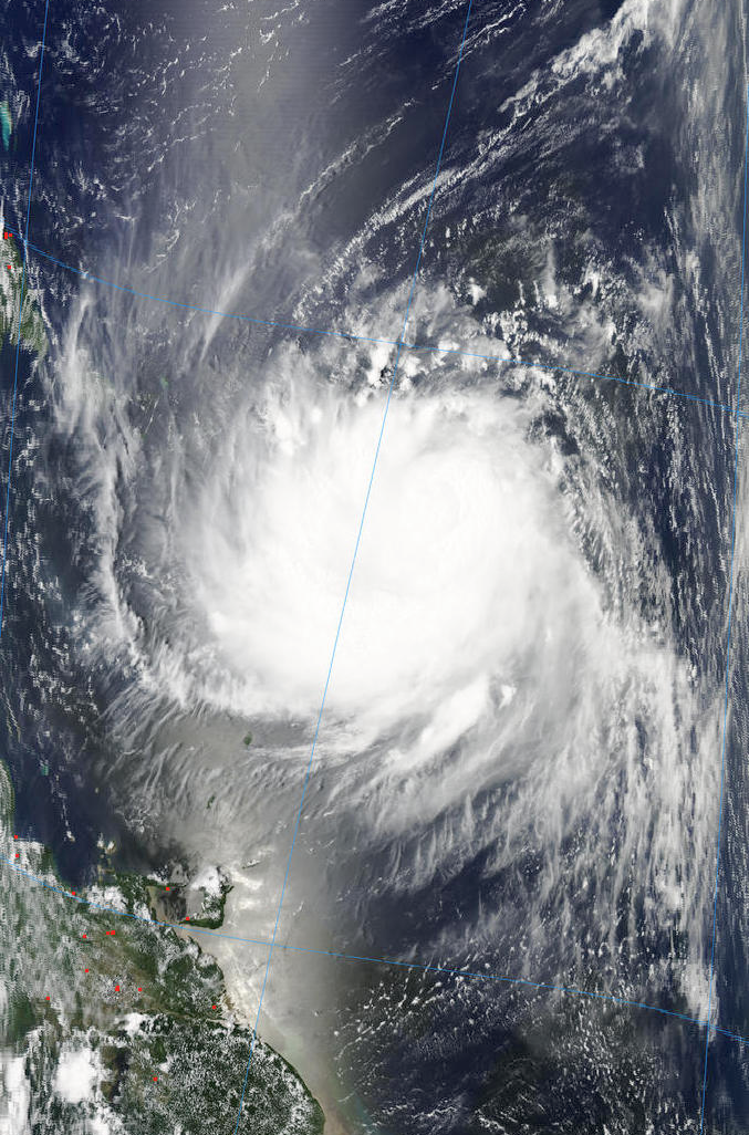
Earl's visible sattelite signature covers an area approximately 15 degrees by 15 degrees or 900 miles north to south and 900 miles east to west. A VERY large system. Visible loop is showing the clouds just north of Puerto Rico moving toward the south. Is the ridge building/ filling in the wake of Danielle?
http://weather.msfc.nasa.gov/GOES/GOES16152010241Mc7uq4.jpg
| Random Chaos |
| (Weather Analyst) |
| Sun Aug 29 2010 05:14 PM |

|
|
|
Earl:
85GHz showing some pretty good banding in the storm. SSMIS overpass shows the west and north portions of the storm, while TMI shows SE parts. I would not be surprised between the pressure drop and the 85GHz if we had a cat 2 before long.
Looking at the long range model run from GFS, we need to watch along the eastern seaboard from North Carolina through Canada. The storm is staying offshore in the US in all models right now, but erosion will be a major threat even if the track doesn't move further west. Trends over the past few days have been a southwestward migration of the medium to long range track, so definitely a storm to keep an eye on.
The biggest question on track: How fast will the ridge form in the wake of Danielle and how fast will the ridge weaken to allow Earl north. A little slower on the weakening and we could see an east coast event.
SSTs are fairly warm along it's entire track also, so there is enough heat to form and maintain a major storm. Long range models show a low over the great lakes around the time the storm is off the eastern seaboard, so shear could effect Earl's health around that time.
References:
85GHz: http://www.nrlmry.navy.mil/tc_pages/tc10/ATL/07L.EARL/ssmi/track_vis/thumb/Latest.html
SSTs: http://www7320.nrlssc.navy.mil/hhc/all_watl.html
Model runs: http://moe.met.fsu.edu/tcgengifs/
|
Ed Dunham
|
| (Former Meteorologist & CFHC Forum Moderator (Ed Passed Away on May 14, 2017)) |
| Sun Aug 29 2010 05:33 PM |
|
|
Just a reminder from the posting guidelines before it gets really busy (see the Site Updates Forum): "The Forecast Lounge: Long -term model discussion on a particular system belong here – most of the posts that get moved here are those that centered on model discussions in excess of 120 hours or long range outlooks for systems that haven’t even formed yet - that were posted in the News Talkback."
If its within the cone, its fair game here - if not, the Lounge is a better place for it.
Thanks,
ED
|
danielw
|
| (Moderator) |
| Sun Aug 29 2010 06:05 PM |
|
|
|
|
NHC and RECON are now reporting Earl's pressure at 978 mb. This is an 8 mb drop in less than 6 hours.
With such a large wind field it will take Earl several hours to convert the pressure drop to an increase in wind speed.
Recent Vortex messages are indicating a opening in the Eyewall further reducing Earl's capability of a rapid increase in wind speeds.
All interests in the Northern Leeward Islands, US and British Virgin Islands particularly St Maarten and Puerto Rico should consult their local weather service and take heed of any Watches and Warnings.
Persons in the Turks and Caicos Islands should monitor Hurricane Earl very closely as the storm could pass over or very close to the Turks and Caicos should the current track play out.
Earl is expected to begin a gradual turn to the northwest in the next 2 to 3 days, per the latest NHC Advisory.
Also of interest is the remarks section of the latest Vortex.
"Remarks Section - Additional Remarks...
MOAT 8NM WIDE CENTERED 16NM RADIUS AROUND EYE NW THRU EAST"
Is this the beginning of an eyewall replacement cycle? Moats are rarely reported.
http://www.google.com/search?hl=en&source=hp&q=hurricane+moat&btnG=Google+Search
http://www.aoml.noaa.gov/hrd/tcfaq/A12.html
Edited vortex messages from today First and Latest.
URNT12 KNHC 291233
VORTEX DATA MESSAGE AL072010
A. 29/11:48:50Z.............. 7:48 AM EDT
B. 17 deg 07 min N
057 deg 41 min W
D. 45 kt...surface wind speed estimate
H. 986 mb
L. OPEN SW-NE
M. C20 naut miles eye diameter
MAX OUTBOUND AND MAX FL WIND 81 KT NE QUAD 12:07:30Z
URNT12 KNHC 291738
VORTEX DATA MESSAGE AL072010
A. 29/17:21:40Z................. 1:21PM EDT
B. 17 deg 22 min N
058 deg 47 min W
D. 65 kt...surface wind speed estimate
H. 978 mb
L. OPEN NW
M. C12
MAX FL WIND 79 KT NE QUAD 15:24:00Z
MOAT 8NM WIDE CENTERED 16NM RADIUS AROUND EYE NW THRU EAST
| Random Chaos |
| (Weather Analyst) |
| Sun Aug 29 2010 07:53 PM |
|
|
|
|
Haven't heard of CAT1 storms going through an ERC, but it sure reads like it is. 20NM eye this morning, 12NM eye now with a 20NM outer eye with the moat note (16 NM radius center on an 8NM wide moat, makes the moat 12-20NM, an inner and outer eyewall).
Could be a facet of the storm's size trying to force a larger eye at this early stage of development. Also, it has just moved over warmer water in the past 12 hours, so that could be affecting its development.
Unfortunately there are no recent microwave passes to show what all is going on.
Edit: HDOB from NOAA3 shows surface pressure now down to 968MB at 20:57Z.
And now for the beauty of Earl, as of 17:20 UTC today:
Source:
North half - http://rapidfire.sci.gsfc.nasa.gov/realtime/single.php?A102411725
South half - http://rapidfire.sci.gsfc.nasa.gov/realtime/single.php?A102411720
| MichaelA |
| (Weather Analyst) |
| Sun Aug 29 2010 09:41 PM |

|
|
|
Earl has become nicely concentric. The forecast discussion brings it to near Cat4 strength in 48 hours. As we've seen, track forecasts have been quite reliable while intensity forecasts have been much less accurate. With Earl traversing warmer waters at a slower forward speed and with minimal shear, we'll see if that intensity forecast verifies.
| Random Chaos |
| (Weather Analyst) |
| Sun Aug 29 2010 10:35 PM |
|
|
|
|
Eye dropsonde shows 973mb
Microwave has a quite well formed inner core now.
Dropsonde: http://www.tropicalatlantic.com/recon/ar...03-11-973-53-10
Microwave: http://www.nrlmry.navy.mil/tcdat/tc10/AT...N-589W.61pc.jpg
| Storm Hunter |
| (Veteran Storm Chaser) |
| Sun Aug 29 2010 11:44 PM |
| Attachment |

|
|
|
Not 100% positive, but today may have been history in RECON flights/Research missions into a tropical System... G-IV completed the Star flight pattern over EARL... C-130 AF Recon is doing there low level invest patterns... P-3s are doing there research missions (both Planes every 12 hrs) and NASA DC-8 is done with its mission and is heading back to US.... not returning to St. Croix due to weather... NASA GV did move over to Barbados with other NOAA aircraft due to weather.
http://www.nasa.gov/mission_pages/hurricanes/missions/grip/main/index.html
| Storm Hunter |
| (Veteran Storm Chaser) |
| Mon Aug 30 2010 12:12 AM |
| Attachment |
|
|
|
|
here's an overlay of todays flights into/above EARL

| Joeyfl |
| (Weather Guru) |
| Mon Aug 30 2010 01:29 AM |

|
|
|
Looks to be just about a due west movement after smoothing over all the wobbles. Looks to be landfall in the northern islands very possibly Puerto Rico based upon the radar loops.
| typhoon_tip |
| (Meteorologist) |
| Mon Aug 30 2010 01:37 AM |
|
|
Watching the Antille's radar closely....
The last ~1.5 hours of looping shows an eye that has contracted... Also, less polarward motion however temporary that may be.
|
MikeC
|
| (Admin) |
| Mon Aug 30 2010 12:57 PM |
|
|
Earl's southern Eyewall is over Anguilla, St. Maarten is not very far away either. Power was lost in St. Maarten around 8:23 AM this morning.
Best place on Radar to look at now is on San Juan Radar.
Check Storm Carib for Updates from the islands
St. Maarten Info from Storm Carib -- Reports of roofs gone, trees down, power out.
{{StormCarib}}
|
MikeC
|
| (Admin) |
| Mon Aug 30 2010 01:20 PM |
|
|
I moved the focus of the radar recording to Puerto Rico.
Radar Recording of Puerto Rico and French Antilles Radar
Now the Virgin Islands will want to watch for the wobbles to see if they get the southern eyewall or it slips to the north. At the very least the southern side is usually the weaker side of the system.
|
Ed Dunham
|
| (Former Meteorologist & CFHC Forum Moderator (Ed Passed Away on May 14, 2017)) |
| Mon Aug 30 2010 01:27 PM |
|
|
At 7AM EDT St. Maarten reported a gust to 61mph - but loss of power since then when the jog to the west put the island in the southern portion of the eyewall. Earl should pass to the north of St. John and St. Thomas later this afternoon.
Current Weather Conditions at St. Thomas
ED
| doug |
| (Weather Analyst) |
| Mon Aug 30 2010 01:41 PM |
|
|
The San Juan radar posted here definitely conforms a due west heading, and that is more than a jog based on how long that has been occuring.
|
danielw
|
| (Moderator) |
| Mon Aug 30 2010 01:49 PM |
|
|
|
|
Due west is Not a good heading right now. That places nearly all of the islands just outside the eye or eyewall. Even those outside the eyewall area will be subject to upsloping winds and torrential rains in mountainous areas.

| Jasonch |
| (Weather Watcher) |
| Mon Aug 30 2010 02:08 PM |
|
|
I agree there is more of a due west heading than north of west.
| Evan Johnson |
| (Weather Guru) |
| Mon Aug 30 2010 02:26 PM |

|
|
|
after my review of the nws long range of puerto rico / virgin islands, i dont see a jog to the west. granted, i am only seeing about 45 min of loops, but i can see a very clear wnw movement of the coc. i may be wrong. either case, it would have to be a pretty consistent movement to the west in order for the 11am from the nhc to reflect it.
|
danielw
|
| (Moderator) |
| Mon Aug 30 2010 02:35 PM |
|
|
|
|
Please remember. NHC directions of movement are averaged over a 6 hour period.
A quick turn in any direction will not show up for several hours. e.g. Hurricane Charley 2004
Use your eyes first and Advisories second in a case of whether the storm has jogged a bit off course... especially if you are in the path of the storm.
|
MikeC
|
| (Admin) |
| Mon Aug 30 2010 02:38 PM |
|
|
Yes it is still west northwest in general (using visible satellite and radar, knowing the angle). It's looking likely the core eyewall will miss the Virgin islands, but it will be borderline close. Still south of the forecasted position though.
|
Ed Dunham
|
| (Former Meteorologist & CFHC Forum Moderator (Ed Passed Away on May 14, 2017)) |
| Mon Aug 30 2010 02:47 PM |
|
|
A jog is only as reliable as the timeframe that someone has seen it in. From about 7AM to 9:30AM, Earl was moving due west. Since then he has moved west northwest. The general average motion since 28/12Z has been to the west northwest, but if you live on one of the islands where a short jog to the west has taken out your power and caused considerable damage...
ED
| Beaumont, TX |
| (Storm Tracker) |
| Mon Aug 30 2010 02:59 PM |
|
|
11 am discussion said the track guidance has shifted westward again. Winds are up to 120 mph.
| scottsvb |
| (Weather Master) |
| Mon Aug 30 2010 03:09 PM |
|
|
Okay, W or WNW.. its 285 degree Average.. .There are some wobbles 300dg there are some 270dg. It's
been generally moving north of due west @ 285. A more WNW motion will happen probably later tonight
with a bending NW on Tuesday. Eyewall contractions will now be in play with Earl as he becomes a solid
Cat 3 with winds approaching Cat 4 tonight.
97L is pretty much a TD.. its lacking consolidated T-Storms near the center..but has enough
and a well defined circulation that it should of been upgraded. Movement is a rapid 24mph.
Curious to see where this goes in the next 48hrs. Should reach the islands then..
|
danielw
|
| (Moderator) |
| Mon Aug 30 2010 04:02 PM |
|
|
|
|
The trough to the northwest of Earl is still digging southward. So Earl should maintain his current heading, so to speak. Not far enough off of the coastline though.
http://www.atmos.washington.edu/~ovens/loops/wxloop.cgi?wv_east_enhanced+6
| MichaelA |
| (Weather Analyst) |
| Mon Aug 30 2010 04:27 PM |
|
|
|
|
I've been curious about that for several days now. Could we see Earl traverse the length of The Bahamas before it makes that turn (heading toward South Carolina), or will it get kicked rather sharply to the NE? Timing is everything right now.
| LoisCane |
| (Veteran Storm Chaser) |
| Mon Aug 30 2010 04:41 PM |

|
|
|
that upper level low will not quit and i think it's feeding earl
whatever is feeding earl he has intensified dramatically and areas far from the center will receive more weather now
great loop to watch... shows so much... hoping this is movement and not a wobble
| MichaelA |
| (Weather Analyst) |
| Mon Aug 30 2010 04:52 PM |
|
|
|
|
It still looks like 285º on current long range radar loop from San Juan. Now has a great radar presentation. We'll see if the forecast shifts even more westward at 5 PM.
|
danielw
|
| (Moderator) |
| Mon Aug 30 2010 05:11 PM |
|
|
|
|
For comparison purposes. Two hours and 53 minutes apart.

| shewtinstars |
| (Registered User) |
| Mon Aug 30 2010 05:13 PM |
|
|
I am in Jacksonville, Florida and this hurricane sure has my attention.
| syfr |
| (Verified CFHC User) |
| Mon Aug 30 2010 05:29 PM |

|
|
|
As someone who planned to be in the outer banks on Saturday, I'm keeping a close eye.
Really looks like the most recent tracks show a NNW direction ...a rather marked change from the western heading earlier today.
|
MikeC
|
| (Admin) |
| Mon Aug 30 2010 05:34 PM |
|
|
The position is on or just a little on the north side of the forecasted track now, It's heading more to northwest than west northwest now. (Again, you need to compare satellite--especially visible--vs radar angle for an accurate position, not radar alone). If the trend continues the forecast track probably will shift right or stay the same at 5PM.
| MichaelA |
| (Weather Analyst) |
| Mon Aug 30 2010 05:37 PM |
|
|
|
|
Looking at the last couple of frames on the Vis loop, it looks like it has resumed a more WNWesterly direction after a NW wobble to me.
|
danielw
|
| (Moderator) |
| Mon Aug 30 2010 06:33 PM |
|
|
|
|
San Juan, PR Morning AFD excerpt could explain the reason for the track anomalies.
.PREV DISCUSSION... /ISSUED 613 AM AST MON AUG 30 2010/
SYNOPSIS...HURRICANE EARL LOCATED OVER THE NORTHERN LEEWARD
ISLANDS WILL CONTINUE TO MOVE WEST AND ACROSS THE LOCAL FORECAST
AREA. THEN ON TUESDAY NIGHT HIGH PRESSURE IN THE WEST CENTRAL
ATLANTIC WILL RIDGE TO THE SOUTHWEST AND INTO THE NORTHEAST
CARIBBEAN...AND CONTINUE UNTIL THURSDAY EVENING. A LOW PRESSURE
SYSTEM WILL MOVE INTO THE EASTERN CARIBBEAN THURSDAY THROUGH
SATURDAY.
http://www.srh.noaa.gov/productview.php?pil=AFDSJU&max=61
PUERTO RICO/U.S. VIRGIN ISLANDS HOURLY WEATHER ROUNDUP
NATIONAL WEATHER SERVICE SAN JUAN PR
200 PM AST MON AUG 30 2010
PRZ001-004-301900-
PUERTO RICO
CITY SKY/WX TMP DP RH WIND PRES REMARKS
SAN JUAN LMM LGT RAIN 81 77 89 NW20G33 29.64F FOG
AGUADILLA PTSUNNY 86 79 79 N20G30 29.78F HX 99
$$
PRZ006-007-301900-
U.S. VIRGIN ISLANDS
CITY SKY/WX TMP DP RH WIND PRES REMARKS
CHARLOTTE AMA LGT RAIN 82 75 78 NW33G59 29.41F
|
danielw
|
| (Moderator) |
| Mon Aug 30 2010 06:37 PM |
|
|
|
|
TROPICAL WEATHER OUTLOOK
NWS TPC/NATIONAL HURRICANE CENTER MIAMI FL
200 PM EDT MON AUG 30 2010
FOR THE NORTH ATLANTIC...CARIBBEAN SEA AND THE GULF OF MEXICO... (edited~danielw)
SHOWERS AND THUNDERSTORMS ASSOCIATED WITH A LOW PRESSURE SYSTEM
LOCATED ABOUT 900 MILES EAST OF THE LESSER ANTILLES HAVE CHANGED
LITTLE IN ORGANIZATION DURING THE DAY.
HOWEVER...AIRCRAFT DATA
FROM A RESEARCH MISSION BEING CONDUCTED BY THE NATIONAL CENTER FOR
ATMOSPHERIC RESEARCH...AS WELL AS SATELLITE DATA... SUGGEST THAT
THIS SYSTEM IS ALREADY PRODUCING TROPICAL STORM FORCE WINDS IN A
SMALL AREA NORTH OF THE CENTER.
ONLY A SMALL INCREASE IN
ORGANIZATION OF THE SHOWER AND THUNDERSTORM ACTIVITY WOULD RESULT
IN THE FORMATION OF A TROPICAL STORM...
AND ADVISORIES COULD BE
INITIATED LATER THIS AFTERNOON OR TONIGHT. THERE IS A HIGH
CHANCE...90 PERCENT...OF THIS SYSTEM BECOMING A TROPICAL CYCLONE
DURING THE NEXT 48 HOURS AS IT MOVES GENERALLY WESTWARD AT ABOUT 20
MPH.
| MichaelA |
| (Weather Analyst) |
| Mon Aug 30 2010 06:57 PM |
|
|
|
|
Is it me, or has Earl slowed down (forward motion) this afternoon? Also, the convection in 97L has, again been suppressed in the latest vis pics.
| ftlaudbob |
| (Storm Chaser) |
| Mon Aug 30 2010 07:34 PM |
|
|
|
|
Earl will need to make the turn real soon,or that projected track will have to change.After a brief wobble more towards the NW,it now is back on a more WNW course.
|
danielw
|
| (Moderator) |
| Mon Aug 30 2010 07:57 PM |
|
|
|
|
MODEL DIAGNOSTIC DISCUSSION
NWS HYDROMETEOROLOGICAL PREDICTION CENTER CAMP SPRINGS MD
233 PM EDT MON AUG 30 2010
VALID AUG 30/1200 UTC THRU SEP 03/0000 UTC
...HURRICANE EARL...
PREFERENCE: NATIONAL HURRICANE CENTER FORECAST
ON WED THROUGH THURS... THE 12Z NAM AND GFS ARE BOTH TRENDING
SLOWER WITH EARL. THE NAM IS SHOWING MORE OF A SOUTH AND WEST
DISPLACEMENT WITH THE TRACK... WHILE THE GFS IS VERY CONSISTENT ON
THE FCST TRACK. THERE STILL REMAINS A FAIR AMOUNT OF SPREAD WITH
THIS FEATURE... ESPECIALLY THE FORWARD PROGRESSION. HPC HIGHLY
RECOMMENDS FOLLOWING THE LATEST FCST GUIDANCE FROM THE NATIONAL
HURRICANE CENTER CONCERNING EARL.
http://www.hpc.ncep.noaa.gov/discussions/pmdhmd.html
| Rich B |
| (British Meteorologist) |
| Mon Aug 30 2010 08:16 PM |
|
|
We now have TD 8 according to FNMOC. Possibly may be classified as a TS at time of issuance of advisories from NHC, but certainly not what those in the northern Leewards will want to see.
| Storm Hunter |
| (Veteran Storm Chaser) |
| Mon Aug 30 2010 08:16 PM |
| Attachment |
|
|
|
|
GV data from flight earlier today found some TS force winds at surface... but NHC is waiting on a good set of convection... which is the right thing to do. Want take much to get a storm, but i don't see anything that would suggest an upgrade at this moment.
PS: the DC-8 from NASA flew over the EYE.... Can't wait to see the pics!
|
Ed Dunham
|
| (Former Meteorologist & CFHC Forum Moderator (Ed Passed Away on May 14, 2017)) |
| Mon Aug 30 2010 08:35 PM |
|
|
I think that Danny was talking about Earl, not Invest 97L, but in any case, if Fleet Numerical is calling the system 08L (and they are) its probably because NHC has told them that NHC is about to upgrade the system to Tropical Depression status at 5PM EDT - but we'll find out shortly.
ED
|
danielw
|
| (Moderator) |
| Mon Aug 30 2010 08:53 PM |
|
|
|
|
NHC has upped 97L to Tropical Storm Fiona
14.4N/ 48.7W wind 40 mph moving W at 24mph 1007 mb
|
MikeC
|
| (Admin) |
| Mon Aug 30 2010 08:55 PM |
|
|
And Earl is now category 4. On the other side, Danielle was downgraded to a Tropical Storm.
|
danielw
|
| (Moderator) |
| Mon Aug 30 2010 09:27 PM |
|
|
|
|
HURRICANE EARL DISCUSSION NUMBER 22
NWS TPC/NATIONAL HURRICANE CENTER MIAMI FL AL072010
500 PM AST MON AUG 30 2010 (edited~danielw)
THE RECONNAISSANCE AIRCRAFT MEASURED 116 KT FLIGHT-LEVEL WINDS AND
108 KT SFMR SURFACE WINDS SHORTLY AFTER 1500 UTC. THIS WAS THE
BASIS FOR THE EARLIER INCREASE IN INTENSITY. SINCE THAT TIME...THE
PRESSURE HAS CONTINUED TO DROP AND WAS DOWN TO 955 MB ON THE LAST
DROPSONDE RELEASED IN THE EYE AROUND 1700 UTC. SINCE THE AIRCRAFT
DEPARTED EARL...THE EYE HAS CONTINUED TO CLEAR AND IS SURROUNDED BY
CLOUD TOPS TO -70 DEGREES CELSIUS OR COLDER. OBJECTIVE SATELLITE
INTENSITY ESTIMATES HAVE INCREASED TO JUST ABOVE 6.0 ON THE DVORAK
SCALE AND SUPPORT AN INITIAL INTENSITY OF 115 KT...CATEGORY FOUR ON
THE SAFFIR-SIMPSON HURRICANE WIND SCALE.
THIS IS A GOOD TIME TO REMIND EVERYONE THAT NHC AVERAGE TRACK
FORECAST ERRORS ARE 200 TO 300 MILES AT DAYS 4 AND 5. GIVEN THIS
UNCERTAINTY...IT IS TOO SOON TO DETERMINE WHAT PORTION OF THE U.S.
EAST COAST MIGHT SEE DIRECT IMPACTS FROM EARL.
948mb That's not good. 1000-948mb = max possible windspeed of 127 mph.
Earl is still Above the pressure-wind relationship curve at 135 mph.
TROPICAL STORM FIONA ADVISORY NUMBER 1
NWS TPC/NATIONAL HURRICANE CENTER MIAMI FL AL082010
500 PM EDT MON AUG 30 2010
...TROPICAL STORM FIONA FORMS EAST OF THE LEEWARD ISLANDS...
SUMMARY OF 500 PM EDT...2100 UTC...INFORMATION
----------------------------------------------
LOCATION...14.4N 48.7W
ABOUT 890 MI...1435 KM E OF THE LEEWARD ISLANDS
MAXIMUM SUSTAINED WINDS...40 MPH...65 KM/HR
PRESENT MOVEMENT...W OR 270 DEGREES AT 24 MPH...39 KM/HR
MINIMUM CENTRAL PRESSURE...1007 MB...29.74 INCHES
WATCHES AND WARNINGS
--------------------
NONE.
INTERESTS IN THE NORTHERN LEEWARD ISLANDS SHOULD MONITOR THE
PROGRESS OF FIONA.
A TROPICAL STORM WATCH MAY BE REQUIRED FOR A PORTION OF THIS AREA LATER THIS EVENING OR TONIGHT.
| MichaelA |
| (Weather Analyst) |
| Mon Aug 30 2010 09:32 PM |
|
|
|
|
With the uncertainty of the intensity forecasts, I would not be surprised if Earl reaches Cat5 intensity within the next 24 hours. Tomorrow will likely tell if the forecast NWesterly track verifies and just how far West that begins to occur.
|
danielw
|
| (Moderator) |
| Mon Aug 30 2010 10:06 PM |
|
|
|
|
New thread, Earl and Fiona, is up. Please post there.