MikeC
|
| (Admin) |
| Mon Aug 30 2010 09:56 PM |
|
|
Update - 12AM EDT, 01 September 2010
No significant changes with the 01/03Z bulletins so really not too much to say. Earl continues to move toward the northwest with an eventual turn to the north and north northeast - passing just offshore the Outer Banks of North Carolina in the very early hours of Friday morning and then offshore from Cape Cod, Massachusetts, in the early hours of Saturday morning on his way to Nova Scotia (as a Cat I hurricane at that time). Watches are up for the eastern coast of North Carolina, and folks north of that area should closely monitor the progress of this very dangerous hurricane.
Fiona maintains as a minimal Tropical Storm - moving west northwest with a more northwest and northerly turn expected in the next couple of days. Little change in intensity is anticipated, however, because Fiona will pass close to (or through) the northern Leeward Islands, the following Tropical Storm Warnings and Watches are in effect:
"A TROPICAL STORM WARNING IS IN EFFECT FOR...
* ST. MARTIN AND ST. BARTHELEMY
A TROPICAL STORM WATCH IS IN EFFECT FOR...
* ANTIGUA...BARBUDA...MONTSERRAT...ST. KITTS...NEVIS...AND ANGUILLA
* ST. MAARTEN...SABA...AND ST. EUSTATIUS"
Fiona will probably only survive for another two or three days before windshear dissipates the weak cyclone.
Invest 98L continues to maintain good structure in the far eastern Atlantic and the convective activity is increasing. The system still has to struggle with dry air for the next couple of days, but after that the conditions for additional development should improve.
ED
5:00 PM EDT Tuesday, 31 August 2010 Update
Hurricane Watches are up Along North Carolina as the outer banks are in the cone of uncertainty. Odds along with most model guidance keeps Earl's center offshore, but close.
Those in the hurricane watch area should pay attention to local officials and media.
Our friend Mark Sudduth at HurricaneTrack.com is located in Wilmington, NC and will have updates from there.
More to come later...
{{MidAtlanticRadar}}
Flhurricane Recording of French Antilles radar for FIona Approach
{{StormCarib}}
{{StormLinks|Earl|07|7|2010|2|Earl}}
{{StormLinks|Fiona|08|8|2010|3|Fiona}}
{{StormLinks|98L|98|9|2010|4|98L}}
5:30 AM EDT Tuesday, 31 August 2010 Update
Hurricane Earl is on the move toward the west northwest and forecast to toward more northwest. On Earl's current track it comes near enough to cause tropical storm force winds from the Carolinas and parts of Cape cod,before moving toward Novia Scotia in Canada. The forecast is for it to stay offshore, but any deviation to the west would bring it inland.
The good news this morning is that it is looking more likely that it will stay offshore since a more northward component is apparent on satellite, but not enough to let guard down. Tropical Storm watches may go up for parts of the Carolinas later today.
However, on the other hand, the fast movement of Fiona behind it may ultimately be enough to nudge Earl more westward. Which is the bad news of the morning (See the image below) Of course it it gets under to the south enough it could "squeeze" it more northward as well.

Tropical Storm Fiona is under conditions that will likely keep it weak or dissipate it, and the current track keeps it quite well out to sea. Fiona is moving too quickly to organize and ramming itself into the influence of Earl, which will likely pull it northward and out to sea.
Odds currently are that Fiona will stay out to sea, but it will still have to be watched until this is certain.
Beyond Fiona, 98L is now being tracked in the East Atlantic, odds are not much will happen with this one, but it has a 10% chance for development. Another wave, currently over Africa, likely has a better chance to develop once over water than 98L does. There are tropical storm Watches up for the Northern Leewards, as they are in the cone. Fiona continues to travel fairly quickly.
Tee last advisory on Danielle was issued at 11 last night.
List of all state/local Emergency management offices
Radar Recording of Puerto Rico and French Antilles Radar
{{StormCarib}}
St. Maarten Webcam - flhurricane recording of this cam
St. Maarten Radar
5:45 PM EDT Monday, 30 August 2010 Update
Earl is now a Category 4 hurricane, and has a chance to strengthen some more before it reaches conditions less favorable for development.
Tropical Storm Warnings are now up for the Turks and Caicos in the Bahamas, and Tropical Storm Watches are up for some of the islands west of there.
Earl is expected to move more northwesterly tomorrow and may get close to the Carolinas before moving more out to sea. However, the cone past 3 days tends to have large errors, so those in the Carolinas northward need to pay very close attention to this system. If Earl nears North Carolina it would be on Friday. Odds favor the system staying offshore of the US coastline, but it still would be close enough to possibly cause windy conditions along the coastline of the Carolinas.


Fiona has developed east of there, and odds are that it will stay out to sea, however the Leewards are in the cone, and will want to watch it. A lot of the forward motion depends on how strong or weak the system remains and when the turn begins. Fiona is moving briskly to the west at 24mph, and is forecast to be at its nearest to the Leewards Wednesday afternoon or evening. There are currently no watches or warnings associated with Fiona, but may later if it appears to impact the islands.
Beyond that, a lot depends on where Earl goes. If Earl moves out quicker, it will give Fiona more of a chance to let the ridge build up and move more west, if it stays slow, it may force Fiona to move out to sea sooner. In short, both systems will need to be watched closely.
And that's not all, another wave off Africa has a chance to develop down the road.
| Raymond |
| (Weather Guru) |
| Mon Aug 30 2010 11:28 PM |
|
|
Looks like Earl will become a cat. 5 relatively soon!
| WeatherNut |
| (Weather Master) |
| Mon Aug 30 2010 11:39 PM |
|
|
Latest pressure on Earl is down to 939mb...
| LoisCane |
| (Veteran Storm Chaser) |
| Mon Aug 30 2010 11:58 PM |

|
|
|
Models a few days ago offered the solution that Earl would suck Fiona into his circulation ... everyone was skeptical. Wondering now if that is possible or he will just keep Fiona at bay a small storm.
Dramatic rapid intensification today... Fiona is beginning to look a lot closer than I would think she should be.
|
MikeC
|
| (Admin) |
| Tue Aug 31 2010 01:02 AM |
|
|
It's fairly likely tomorrow we'll begin to see watches up on the east coast. Especially if Earl picks up more forward speed.
| ftlaudbob |
| (Storm Chaser) |
| Tue Aug 31 2010 01:56 AM |
|
|
|
|
Earl went from a TS to a CAT4 hurricane in 27 hours.This just shows us once again how fast these storms can gain strength.
| Random Chaos |
| (Weather Analyst) |
| Tue Aug 31 2010 01:59 AM |

|
|
|
We can't end the day without another beauty shot of Earl.
Taken around 11am today:

Source: http://rapidfire.sci.gsfc.nasa.gov/gallery/?2010242-0830/Earl.A2010242.1500.2km.jpg
There was a more recent picture taken around 3pm, but it caught the storm almost edge on: http://rapidfire.sci.gsfc.nasa.gov/realtime/single.php?A102421805
| craigm |
| (Storm Tracker) |
| Tue Aug 31 2010 02:14 AM |
| Attachment |

|
|
|
Not wanting to get to caught up in model fluctuations I am just wondering why the 18Z GFDL run at the cyclogenesis potential site is not mating up with Skeetobite GFDL 18 Z and SFWMD GFDL 18 Z. See attached.
Trust the cone.
| lordvector |
| (Registered User) |
| Tue Aug 31 2010 02:24 AM |
|
|
Quote:
Earl went from a TS to a CAT4 hurricane in 27 hours.This just shows us once again how fast these storms can gain strength.
I calculate 33 hours from TS @ 8am yesterday to CAT4 @ 5pm today.
| Random Chaos |
| (Weather Analyst) |
| Tue Aug 31 2010 02:28 AM |
|
|
|
|
Quote:
18Z GFDL run at the cyclogenesis potential site is not mating up with Skeetobite GFDL 18 Z
The model plot you are looking at is Fiona's, not Earl's. Earl's does match up.
I was noticing that yesterday with 97L not matching up with Earl's plot with the same strong westward shift. Perhaps a Met that knows the models better than I can help explain why the discrepancy between Earl's track on the the 07L (Earl) and 08L (Fiona) model runs from GFDL.
Reference model runs: http://moe.met.fsu.edu/tcgengifs/
| craigm |
| (Storm Tracker) |
| Tue Aug 31 2010 02:39 AM |
| Attachment |
|
|
|
|
RC-- You are absolutely right I was looking at 08 not 07. Iv'e attached the correct file although I'm still not sure why 08 18z run is showing Earl that far west unless there is just stray data.
|
Ed Dunham
|
| (Former Meteorologist & CFHC Forum Moderator (Ed Passed Away on May 14, 2017)) |
| Tue Aug 31 2010 03:02 AM |
|
|
If your question is 'Why does the track for Earl look different when I look at the GFDL output for Fiona?', then
I think that the answer you are seeking is in the Hurricane Ask/Tell Forum in a thread that is titled: TS Earl Model Output Solutions. If thats not where you were heading then help me out by clarifying what is confusing.
Cheers,
ED
|
danielw
|
| (Moderator) |
| Tue Aug 31 2010 11:57 AM |

|
|
|
These two images are nearly 6 hours apart. At first glance the motion appears to be NW or NNW.
Rough calculation of the radar center movement is toward 318 degrees, NW at 12.5 mph. Please refer to Official NHC Advisories for planning and safety purposes.


| Random Chaos |
| (Weather Analyst) |
| Tue Aug 31 2010 12:39 PM |
|
|
|
|
Latest recon pass shows pressure up 4mb from late last night. However, while San Juan radar still shows the 16NM eyewall somewhat intact, recon reported the eye size at 30NM, indicating the ERC is well underway. IR shows the eye now occluded, likely a result of the ERC. Probably another 6 hours for the ERC cycle to wrap up and the storm to start strengthening again. NHC reported that it would be entering less hospitable conditions in around 12-24 hours, so it looks like the ERC will finish fast enough to be done prior to those conditions, which is good for the hurricane (and not so good for those of us not liking the track of the hurricane).
| stormtiger |
| (Weather Hobbyist) |
| Tue Aug 31 2010 03:11 PM |
|
|
forming over the Northern Bahamas. I'm watching Fiona racing up Earl's "backside". Very interesting scenario here.
http://www.meteo.psu.edu/ewall/SAT_ATL/atlanimwv.html
If the cutoff low sinks further South, could it help turn Earl away for the CONUS and then turn it more back towards the West and NC?
Or is the ULL not really a factor in how Earl tracks, and everything is dependant on the high pressure ridge and the trough over the continent?
Right now it appears Earl is hanging on to his 135 cat 4 winds, but he doesn't look nearly as impressive as he did yesterday when cat 5 strength was a real possibility. The NHC is forecasting a little strengtheing later but not today depending on the current ERC and its end result.
Early has been an interesting storm to follow.
| Joeyfl |
| (Weather Guru) |
| Tue Aug 31 2010 03:40 PM |

|
|
|
Not sure if I am buying into Fiona turning like they are saying looks to be racing just north of west. With it staying fairly weak I question it going more poleward? I lean a little more towards the Bam models here...
| scottsvb |
| (Weather Master) |
| Tue Aug 31 2010 03:41 PM |
|
|
For the time being, lets also look @ Fiona. She has been hit by 2 things 1 Dry Air..but really more importantly is her speed @ 23-25mph during the past 2-3 days. Same thing started with Earl... once he slowed down to 18mph (not much of a slowdown) he quickly became a hurricane.
Now with that said, I don't expect Fiona to become a hurricane in the next 24-36hrs...but Fiona over the next 12-36hrs will determine so much with her.
Lets look at things. Models jump the gun too much and don't have a strong enough ridging so far this year over the tropical atlantic.. This is why Earl kept going more W and didn't go north of 20N until 66.5W (about). Fiona is suppose to turn more NW today and NNW near 60W by Weds morning. The WV imagery shows that Earl is actually bringing up the heights to his east on the ridge. Also the ridge moves quickly W in the next 48-60hrs and lies pretty much along 22N from 70W out to Bermuda. This causes Earl to move N and then NE around it but where will Fiona be? Models say somewhere around 25N and 65W in 60hrs. I really can't grasp that cause of Fiona slowing down some as she approaches 60W and I feel 16.8N and moving more WNW later this evening and tonight...then a more NW path towards U.S. British Islands and even maybe Puerto Rico Weds afternoon and night. This is cause the models have been too weak this year with the ridging and wanting to pull systems around the ridge too quickly.
It be interesting also on if she strengthens some tonight. Shear will pick up on Weds in the wake of Earl, but I don't think the shear maps are telling the story correctly also in the near term.
So thing is.. next 12-36hrs will be key. When will Fiona turn NW or even NNW (if the models do have it correctly) or will Fiona move more WNW tonight and not turn NW until sometime on Weds or Weds night? Also what will the shear be from Earl? The short term in path,speed, shear zone, and strength will be important over this time frame.
| Wingman51 |
| (Weather Guru) |
| Tue Aug 31 2010 04:49 PM |
|
|
|
|
In response to your analysis - the latest NGP run reflects on Fiona stalling and looping off the FL Coast at 6 and 7 days out. This seems to be a direct result of Earl "cleaning" things out and leaving little in his path to steer Fiona. Thoughts?
|
danielw
|
| (Moderator) |
| Tue Aug 31 2010 04:55 PM |
|
|
|
|
URNT12 KNHC 311535
VORTEX DATA MESSAGE AL072010
A. 31/15:22:10Z
B. 21 deg 09 min N
067 deg 59 min W
C. 700 mb 2591 m
D. 80 kt
E. 121 deg 23 nm
F. 201 deg 104 kt
G. 121 deg 35 nm
H. 941 mb
I. 12 C / 3051 m
J. 21 C / 3028 m
K. 19 C / NA
L. NA
M. NA
N. 12345 / 7
O. 0.02 / 0.5 nm
P. AF309 0607A EARL OB 20
MAX OUTBOUND AND MAX FL WIND 128 KT NE QUAD 15:31:10Z
| Storm Hunter |
| (Veteran Storm Chaser) |
| Tue Aug 31 2010 04:56 PM |

|
|
|
for those intrested... you should see these pics from the Global Hawk on Frank. This was a test flight and expect to see the Hawk fly over Earl later this week!
http://www.aoml.noaa.gov/spotlight/NOAA-NASA%20Global%20Hawk.pdf
| Bloodstar |
| (Moderator) |
| Tue Aug 31 2010 05:06 PM |

|
|
|
Quote:
In response to your analysis - the latest NGP run reflects on Fiona stalling and looping off the FL Coast at 6 and 7 days out. This seems to be a direct result of Earl "cleaning" things out and leaving little in his path to steer Fiona. Thoughts?
Personally, I can't imagine Fiona stalling and looping right now, While steering currents may weaken in a short term, I think the model in question has kinda missed with the latest run. If other models start picking the idea of a stall or loop, then it could be worth looking into.
Now mind you, we are looking at a steering environment made more complicated by a major hurricane. So the models may have more trouble handling a vastly stronger storm relatively close to a weaker one. The models may handle it fine, but it's worth keeping in mind for each run.
|
danielw
|
| (Moderator) |
| Tue Aug 31 2010 06:54 PM |
|
|
|
|
Fiona's BAMD is an outlier, off topic, But it appears to be following the CIMSS steering current maps. To some degree.
http://moe.met.fsu.edu/~acevans/models/al082010.png
Steering Currents for > 1000mb
|
MikeC
|
| (Admin) |
| Tue Aug 31 2010 07:15 PM |
|
|
Earl's eyewall replacement cycle may be nearly over, and the result may be a smaller (and more turbulent) eye , which may give it a shot to strengthen more. Dry air to the northwest may starve Earl and weaken it some on the other hand.
| MichaelA |
| (Weather Analyst) |
| Tue Aug 31 2010 07:26 PM |

|
|
|
Although, it does appear that there may be some dry air advection beginning on the W and SW side and some hint of increasing shear as well, looking at both the vis loop and WV loop.
| Old Sailor |
| (Storm Tracker) |
| Tue Aug 31 2010 07:45 PM |

|
|
|
The latest run on Earl with ECMWF 1200Z shows Boston as the bull eyes, time will tell but feel eastern New England is under the gun...
| bobbutts |
| (Weather Hobbyist) |
| Tue Aug 31 2010 07:55 PM |

|
|
|
Not quite Boston..

| k___g |
| (Weather Guru) |
| Tue Aug 31 2010 08:03 PM |

|
|
|
Based on the current visuals, Earl has made his turn poleward!!! He will send some high tides and stormy weather into the U. S. East coast but that should be it. However, areas north of Maine need to watch out.
|
danielw
|
| (Moderator) |
| Tue Aug 31 2010 08:12 PM |
|
|
|
|
Something has flattened Earl's Western and Southern sides. A Square Hurricane???

| ftlaudbob |
| (Storm Chaser) |
| Tue Aug 31 2010 08:29 PM |
|
|
|
|
Quote:
The latest run on Earl with ECMWF 1200Z shows Boston as the bull eyes, time will tell but feel eastern New England is under the gun...
Looks to me like the bulls eye is Rhode Island.
| MichaelA |
| (Weather Analyst) |
| Tue Aug 31 2010 08:31 PM |
|
|
|
|
It looks like another wobble, similar to yesterday's to me. It's still pretty much on a mostly WNW path with maybe a slight tendency more toward NW.
| Rad |
| (Weather Guru) |
| Tue Aug 31 2010 08:32 PM |

|
|
|
Quote:Dont worry , It will change by thenQuote:
The latest run on Earl with ECMWF 1200Z shows Boston as the bull eyes, time will tell but feel eastern New England is under the gun...
Looks to me like the bulls eye is Rhode Island.
|
danielw
|
| (Moderator) |
| Tue Aug 31 2010 08:41 PM |
|
|
|
|
DRY Air Entrainment. Excellent photo. Thanks NOAA.
If this dry air keeps going Earl might just Poof.

| bobbutts |
| (Weather Hobbyist) |
| Tue Aug 31 2010 08:51 PM |
|
|
|
|
Quote:Quote:
The latest run on Earl with ECMWF 1200Z shows Boston as the bull eyes, time will tell but feel eastern New England is under the gun...
Looks to me like the bulls eye is Rhode Island.
No.. the center is well east of both Boston and Rhode island (on the 12z euro)
|
danielw
|
| (Moderator) |
| Tue Aug 31 2010 09:10 PM |
|
|
|
|
I hate to ask you guys to stop the dialogue about the models. But 5 days is a long period in the tropics.
Models are very inconsistant at 5 days... with 360 mile/ 6 degrees of leeway left or right of track.
If you would like to continue the model discussion you can discuss at will in the Forecast Lounge.
Current model departure at 120 hour/ 5 day ranges from the EGRR model at 325 sm to the BAMD at 779 sm.
http://www.tropicalatlantic.com/models/d...verage#position
http://www.tropicalatlantic.com/models/data.cgi?basin=al&year=2010&storm=07
THIS PRODUCT IS UNDER DEVELOPMENT. FEEL FREE TO TEST IT,
BUT DO NOT TRUST THE OUTPUT UNTIL MORE TESTING IS DONE.
| MichaelA |
| (Weather Analyst) |
| Tue Aug 31 2010 09:44 PM |
|
|
|
|
I noticed that a couple of hours ago.

Earl is still trying to ignore that entrainment and appears to be trying to suck what life Fiona has out of her too.
|
danielw
|
| (Moderator) |
| Tue Aug 31 2010 10:05 PM |
|
|
|
|
Earl appears to be fighting the dry air entrainment by placing a wall on the western side of the center.
Shaped like a croissant the western side is steadily gaining height while the NE Quadrant is eroded to a much lower height.
Notice the thin cirrus fingers on the western side. Dry air has abated somewhat, or dropped to lower levels, as they cover more of the western semicircle than a few hours ago.

| MichaelA |
| (Weather Analyst) |
| Tue Aug 31 2010 10:13 PM |
|
|
|
|
Earl is regaining symmetry again, so the dry air was insufficient to have had a lasting effect it seems. It looks like that NWesterly turn is beginning to take shape too.
| Random Chaos |
| (Weather Analyst) |
| Tue Aug 31 2010 10:16 PM |
|
|
|
|
I think in many ways the water vapor image shows your point even better, Daniel. You can really see the dry air spun into the storm just north of the COC.
Regional:
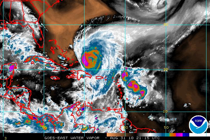
Floater:

Also, no beauty pictures today. TERRA and AQUA's overpasses were all edge-on views of the storm today.
| civil2183 |
| (Registered User) |
| Tue Aug 31 2010 10:38 PM |
|
|
Just a passive observer of the site. It seems to only be briefly mentioned, but it seems clear to me that Earl has been drawing Fiona into itself over the past day. I know in the past, this has happened (I believe it was the 95 season I saw it happen, might of been Karen), though rarely, that the stronger storm swallows the weaker storm. I believe it also effects the stronger storm during this process. Can anyone give some clarity to what the effects on Earl will be during this process? How long this might take and do the models have this predicted in already?
Thanks
| mcgowanmc |
| (Weather Hobbyist) |
| Tue Aug 31 2010 10:57 PM |
|
|
Yes. This is exactly what is happening.
http://www.ssd.noaa.gov/goes/east/watl/flash-wv.html
This will push Earl farther to the West. Maybe South Carolina Cat 5.
Connie/Diane 1955 came close until this pm.
Tomorrow Dawn, Earl will be a different hurricane.
| bobbutts |
| (Weather Hobbyist) |
| Tue Aug 31 2010 11:01 PM |
|
|
|
|
Quote:
Just a passive observer of the site. It seems to only be briefly mentioned, but it seems clear to me that Earl has been drawing Fiona into itself over the past day. I know in the past, this has happened (I believe it was the 95 season I saw it happen, might of been Karen), though rarely, that the stronger storm swallows the weaker storm. I believe it also effects the stronger storm during this process. Can anyone give some clarity to what the effects on Earl will be during this process? How long this might take and do the models have this predicted in already?
Thanks
This is called the Fujiwara Effect
Considering NHC doesn't even mention Fiona in their discussion I think it's a good bet it won't be a major factor in steering for Earl.
Earl Discussion
Quote:
THE SUBTROPICAL HIGH THAT IS
STEERING EARL TOWARD THE WEST-NORTHWEST OR NORTHWEST IS FORECAST TO
GRADUALLY SHIFT EASTWARD AS A BROAD TROUGH BECOMES ESTABLISHED OVER
THE EASTERN UNITED STATES. THIS PATTERN WILL FORCE EARL ON A MORE
NORTHWESTERLY AND NORTHERLY TRACK FOR THE NEXT DAY OR TWO.
THEREAFTER...EARL WILL REACH THE BASE OF THE MID-LATITUDE WESTERLIES
AND WILL LIKELY TURN SHARPLY TO THE NORTHEAST WITH AN INCREASE IN
FORWARD SPEED. THIS IS THE SOLUTION UNANIMOUSLY PROVIDED BY TRACK
GUIDANCE.
| Random Chaos |
| (Weather Analyst) |
| Tue Aug 31 2010 11:06 PM |
|
|
|
|
This really isn't the right forum for the question, but I'm going to try and answer it anyway.
The simple answer is: Hurricanes don't merge, as such.
Lets look at the physics of this:
1. Themodynamics: Two engines drawing from the same fuel source means that two engines will run out of fuel faster than one engine. A hurricane is an engine that runs on warm ocean waters, meaning that eventually both storms cannibalize the ability of the other storm to survive and/or strengthen.
2. Conservation of Angular Momentum: Two gears spinning the same direction (lets say clockwise for arguments sake) smack into each other. If the gears are equal size, they will both stop spinning. If one gear is smaller than the other, the larger gear will slow while the smaller gear will stop spinning. You can think of a hurricane as a giant spinning gear. When two storms near each other, the shear from the larger one will litterally rip apart the smaller storm, while the larger storm will be weakened by the shear from the smaller storm. The closer the storms are in strength, the weaker the resulting storm will be.
So what will happen if Fiona and Earl continue to be so close together? Eventually Fiona will probably fall apart and then Earl will stop feeling the negative effects of Fiona. This will in turn allow Earl will strengthen.
Many times this is described as "absorbing" or "merging" but in reality is is a result of the negative effects of the weaker storm no longer being present.
You also want to look up the Fujiwhara effect which affects the motion of storms in close proximity.
|
Ed Dunham
|
| (Former Meteorologist & CFHC Forum Moderator (Ed Passed Away on May 14, 2017)) |
| Tue Aug 31 2010 11:13 PM |
|
|
What we don't do on this site is get into unjustified wild speculation, i.e., hype. There is no sound meteorological reason for Earl to suddenly become a Cat V hurricane tomorrow - quite the opposite is true. With the potential for additional dry air entrainment and some shearing from an upper level disturbance, there IS sound meteorological reasoning for Earl to weaken a bit.
The Fujiwhara effect has nothing to do with one storm wiping out another - it is when two storms tend to rotate around each other.
There is a thread in the Forecast Lounge for Earl and another thread for Fiona - use these for arguing your point about a location of a storm on a long range model output.
ED
| Random Chaos |
| (Weather Analyst) |
| Wed Sep 01 2010 01:27 AM |
|
|
|
|
Satellite presentation is looking poor. Microwave shows the eye entirely open south. Water vapor shows a large amount of dry air entrainment. A couple hours ago the eye looked to be clearing, but since then the eye has mostly filled in again and the convection has significantly weakened.
References:
IR and WV: http://www.ssd.noaa.gov/PS/TROP/float2.html
Microwave: http://www.nrlmry.navy.mil/tcdat/tc10/AT...N-683W.71pc.jpg
P.S. Anyone know what is going on with NOAA SSD? Their site keeps going down and/or reverting to the 1996 version periodically. Been happening regularly over the past couple hours.
|
MikeC
|
| (Admin) |
| Wed Sep 01 2010 02:04 AM |
|
|
We're now recording the French Antilles radar for Fiona. Link here
|
danielw
|
| (Moderator) |
| Wed Sep 01 2010 02:07 AM |
|
|
|
|
I have tried several of my links to the SSD site to no avail.
No message of any outage or server problems. My best guess is overload as they were transmitting 4,300mb of data earlier.
Most everyone is watching Earl and from this site it appears that the West Coast is watching Earl also.
http://www.websitetrafficspy.com/www.ssd.noaa.gov
|
danielw
|
| (Moderator) |
| Wed Sep 01 2010 02:22 AM |
|
|
|
|
Most recent, 10:01pm EDT, water vapor image is the bottom image. Two and a half hours difference between the two images.
Earl needs to turn real soon.


|
Ed Dunham
|
| (Former Meteorologist & CFHC Forum Moderator (Ed Passed Away on May 14, 2017)) |
| Wed Sep 01 2010 02:42 AM |
|
|
Note that SSD is back online.
Invest 98L is still holding its own with a well defined envelope of circulation.
Earl has indeed made the turn to the northwest which is good news. Earl finally has an eye again - first time that I can recall a Cat IV going for such a long time without a clearly defined eye, but the recon reports did support the intensity. Some entrainment of dry air may have disrupted the hurricane a little - and more of that is still a possibility.
For a long time I thought that perhaps the upper outflow from Earl was going to shred Fiona, but now with Earl moving a little quicker to the northwest, I'm not so sure - she might survive for awhile.
ED
| Random Chaos |
| (Weather Analyst) |
| Wed Sep 01 2010 02:44 AM |
|
|
|
|
Did a little investigation on SSD failures - looks like there is a routing and/or DNS issue.
Route one: Maryland via Qwest to the NOAA server banks in Silver Spring, MD. Loads the bad 1996 server software.
Route two: Maryland via Level 3 to Texas and then into a server farm in Texas. Loads the correct 2009 server software.
My guess is someone turned on some old servers that are supposed to be long shut down and one of them is sending out some bad routing data.
I emailed SSD's webmaster email address to let them know my info - hopefully they can fix it pretty quickly tomorrow, but doubt anything will happen until then.
|
danielw
|
| (Moderator) |
| Wed Sep 01 2010 04:28 AM |
|
|
|
|
Two RECON Flights tonight. The first flight is now inbound to Earl and should be near Earl's center in an hour.
The second flight is readying for takeoff and should be providing data in the next half hour while inbound to Fiona.
| scottsvb |
| (Weather Master) |
| Wed Sep 01 2010 04:59 AM |
|
|
whats the recon page link again Daniel to follow
(I'm not familiar with it, but in the future please use the PM capability when requesting something from an individual.)
| scottsvb |
| (Weather Master) |
| Wed Sep 01 2010 07:16 AM |
|
|
HH found pressure just under 1001mbs with winds around 50mph @ the surface with Fiona. Location just east of the 2am NHC advisory of 17.3N and 59.8W
| MichaelA |
| (Weather Analyst) |
| Wed Sep 01 2010 01:37 PM |
|
|
|
|
Still a no go on the sat pics so far this AM. I hope they get it fixed soon. Nothing like flying blind.
Just came back online. (0940 EDT)
Well, partially up (0945 EDT).