MikeC
|
| (Admin) |
| Wed Sep 01 2010 06:03 AM |
|
|
8AM EDT Update - Sunday, 5 September 2010
Earl is no longer, Ex-Gaston and an area in the Bay of Campeche (90L) Both have a chance to form today or tomorrow.
The area east of Gaston fell apart and is no longer being tracked as 99L.
90L has a chance to make tropical storm status before moving inland in Northern Mexico or extreme southern Texas, but it will not have the time to strengthen.
{{StormLinks|Ex-Gaston|09|9|2010|4|Ex-Gaston}}
{{StormLinks|90L|90|10|2010|1|Invest 90L}}
b]4PM EDT Update - Saturday, 4 September 2010
Earl is inland over Nova Scotia in Canada. The remnants of Gaston are set to reform likely later tonight or tomorrow, and another disturbance in the Southwest Gulf of Mexico has a shot at forming into a Tropical Storm tomorrow before Landfall in Northeast Mexico or southern Texas (not currently an invest). And Fiona dissipated. The other system east of Ex-Gaston (99L) will have to be watched later in the week as well.
Gaston's Remnants are likely to edge along the Northern Leewards and just north and continue westward, so it appears the Bahamas and perhaps Florida will want to watch what happens with what was Gaston later this week. Those in the Leewards will want to watch even sooner because if it redevelops they will likely be in the cone.
{{StormCarib}}
{{StormLinks|Earl|07|7|2010|2|Earl}}
{{StormLinks|Ex-Gaston|09|9|2010|4|Ex-Gaston}}
{{StormLinks|99L|99|10|2010|1|Invest 99L}}
11PM EDT Update - Friday, 3 September 2010
Earl is now a strong Tropical Storm moving about 80 miles southeast of Cape Cod and heading toward eastern Nova Scotia on Saturday. Sustained winds are now at 60 knots and Earl is moving to the northeast at 22 knots. Updated Warnings and Watches are listed in the Meteorological Blog.
New England Hourly Weather Reports
Fiona has degenerated into a remnant low that is expected to dissipate over the weekend.
The former Gaston is once again developing deep convection and will likely become a tropical cyclone again over the weekend as the system moves to the west northwest.
Invest 99L is slowly organizing off the west coast of Africa as it moves to the northwest at about 8 knots. Still not certain as to whether 99L will be able to survive the dry air environment that it is moving into.
ED
7:00 AM EDT Update Friday, 3 September 2010
t

Earl is Northeast of Cape Hatteras this morning, and most of the wind has stayed offshore, with the extreme eastern outer banks seeing strong tropical storm force winds.
Hurricane Earl is expected to near Cape Code in the Early Morning hours tomorrow.
8:30 PM EDT Update Thursday, 2 September 2010
Earl is nearing the North Carolina Coastline, but is moving more northerly now and thankfully, it appears the center of the system will not make landfall, although winds will be very high. Earl has weakened to a category 2 storm
Those in the Cape Cod area will like also see a very close call.
Gaston has been downgraded to an open wave, but may regenerate later and will be watched.
{{MidAtlanticRadar}}
{{SERadar}}
{{NERadarComposite}}
{{NERadar}}
Flhurricane Recording of Radar (and more) of Earl US Approach
Keep up with where Mark Sudduth (Hurricanetrack.com) is as he drives around the Outer Banks of North Carolina
Hatteras Lighthouse Cam flhurricane recording
Kill Devil Hills Pier Video Stream
Flhurricane recording of HurricaneTrack's Tower Cam
Media:
WECT 6TV - Wilmington, NC
WITN 7 - Eastern North Carolina TV (NBC)
WCTI 12 - Eastern North Carolina (ABC)
WNCT TV 9 - Eastern North Carolina (CBS)
Wavy 10 (NBC) - Hampton Roads/VA Beach, VA TV
WTKR 3 (CBS) - Hampton Roads/VA Beach, VA
WVEC 13 (ABC) - Hampton Roads/VA Beach, VA
Papers:
Outer Banks Sentinel
Wilmington Star News Online
Hampton Roads Pilot
Keep up with where Mark Sudduth (Hurricanetrack.com) is as he drives around the Outer Banks of North Carolina
{{CHC}}
Flhurricane Recording of French Antilles radar for FIona Approach
{{StormCarib}}
{{StormLinks|Earl|07|7|2010|2|Earl}}
{{StormLinks|Fiona|08|8|2010|3|Fiona}}
{{StormLinks|Gaston|09|9|2010|4|Gaston}}
{{StormLinks|99L|99|10|2010|1|Invest 99L}}
6:15 AM EDT Update Thursday, 2 September 2010
Hurricane Earl has probably peaked earlier this morning, but remains a strong category 4 storm. It is forecast to come very close (40-60 miles) of the outer banks, still as a major hurricane. Any deviation to the west would bring the worst of it onshore. Those in the warning areas should pay attention to local media and officials about any evacuations or recommendations.
Today should be spent in final preparations and leaving as conditions will begin to deteriorate in North Carolina in the late afternoon or evening. Closest approach to North Carolina would likely bit in pre-dawn hours tomorrow.
After passing near/over North Carolina, Earl is forecast to stay offshore the mid Atlantic, but Nantucket has a chance to get part of the western eyewall. Because of this hurricane watches are in effect now (in addition to the other warnings/watches) from north of the NC/VA Border to Cape Henlopen in Delaware. And now also from westport to Plymouth, MA (along with cape code/Martha's Vineyard and Nantucket) Those in Martha's Vineyard and Nantucket would be wise to begin preparations now.

Wind fields tend to expand when the storms get further north, so there is a good chance a large area in the northeast may experience some strong winds.
Beyond that, Extreme Northeast Maine may be a landfall, and Canada will either way, and it is likely Earl still will be a hurricane when it does.
Fiona is on the out to sea path, but has a chance to come close to Bermuda (on the west side). Therefore Bermuda is under a Tropical Storm watch for FIona.
Gaston is remaining weak this morning, but expected to continue to track west. Gaston is moving much slower than the other storms, and may not reach closer to the Leeward islands until mid-late next week. Odds favor Gaston not going out to sea, so it will be one to watch then.
Beyond Gaston is another wave (not being tracked as a proper invest yet) that has a 10% chance to develop over the next 48 hours, but more of one later on.
8:30PM EDT Update Wednesday 1 September 2010
Recon airfract has found a lower pressure in Earl of 932mb, which indicates Earl is continuing to strengthen.
Those still on the outer banks are highly recommended not to take the risk of a major storm approaching your area and leave.
Odds favor the center of it staying offshore, but the large size will still pound hurricane force winds along parts of the coast.


6:00PM EDT Update Wednesday 1 September 2010
Earl has continued to strengthen with maximum sustained winds reaching 135MPH and Tropical Depression 9 has become Gaston, the 7th tropical storm of the season.

Meanwhile Fiona is struggling and may not survive to the weekend. Since Gaston remains far from land, all eyes remain on Earl with Tropical Storm and Hurricane Watches and Warnings stretching from North Carolina to the New Hampshire border.
There is another wave just off Africa (east of Gaston) that we'll need to watch next week also.
10:30AM EDT Update Wednesday 1 September 2010
The wave in the Central Atlantic looks to be upgraded to Tropical Depression 9 at 11AM.
Hurricane Earl was re-upgraded to Category 4 status, and Earl is forecast to remain a major as it goes right next to the outer banks of north Carolina. With a storm of this size, I would not stay on the outer banks if you are there.
8AM EDT Update Wednesday 1 September 2010
Fiona has strengthened a bit since influence from Earl has been decreasing, it is now up to 60MPH Winds.
Chances for Development of the wave in the central Atlantic (98L) have gone up to 80%. This system would be named Gaston, and odds favor the more westerly track.
See original update for Earl information:
Original Update
Hurricane Earl has weakened a bit overnight due to dry air and small amounts of shear, but it is still a major hurricane. Earl is forecast to be at it's closest point to the outer banks of North Carolina Thursday night into Friday morning.
The majority of models keep Earl just offshore, but close enough to cause problems. A few, such as the NOGAPS take it inland into North Carolina. Those in the warning area, In short, prepare for the worst and hope for the best, and you should be looking at local advisories, officials, and Media.
The Hurricane Watches for North Carolina may be upgraded to Hurricane Warnings later today.
Those north of there along the coast will want to watch Earl closely for any changes or additional watches and warnings. Especially in Eastern Massachusetts/Cape Cod.
Those in Canada in the forecast track zone should begin to prepare as well.

Tropical Storm FIona is being caught up in the northerly flow from Earl, and currently is just offshore North and East of the Leeward islands, the official forecast takes it northward and eventually stalls near Bermuda, but there is some uncertainty with the forecast so the next day or two is critical for the eventual path of FIona. Fiona will likely stay weak, unless effects from Earl drop off quicker than expected or a center relocation southward happens. Fiona is still very much worth watching.
Tropical Storm warnings and Watches are up for the Leewards for Fiona.
Out east of both is the wave 98L, which now has a 50/50 shot at development over the next few days. Odds favor this going generally westward, so those in the Leewards, again, will have to watch it closely.
Another system just over the west side off Africa also has a chance to develop into next week, and odds favor it moving more westward (Ie not out to sea) as well.
|
MikeC
|
| (Admin) |
| Wed Sep 01 2010 06:47 AM |
|
|
Fiona is looking very interesting right now, (not strong, just interesting). It's not quite caught up in Earl, and a lot of the convection is south of the center. And I'm very curious to see if the current Fiona forecast track sticks or not.
Those in the outer banks will want to keep watch on Earl.
|
MikeC
|
| (Admin) |
| Wed Sep 01 2010 07:04 AM |
|
|
Added several links to the main page in prep for Earl/Fiona:
{{MidAtlanticRadar}}
Media:
WECT 6TV - Wilmington, NC
WITN 7 - Eastern North Carolina TV (NBC)
WCTI 12 - Eastern North Carolina (ABC)
WNCT TV 9 - Eastern North Carolina (CBS)
Wavy 10 (NBC) - Hampton Roads/VA Beach, VA TV
WTKR 3 (CBS) - Hampton Roads/VA Beach, VA
WVEC 13 (ABC) - Hampton Roads/VA Beach, VA
Papers:
Outer Banks Sentinel
Wilmington Star News Online
Hampton Roads Pilot
{{CHC}}
Flhurricane Recording of French Antilles radar for FIona Approach
{{StormCarib}}
Also Mark Sudduth Tracker Sudduth Tracker/Hurricanetrack
| Random Chaos |
| (Weather Analyst) |
| Wed Sep 01 2010 07:59 AM |

|
|
|
Just a few notes this morning.
Earl:
1. Earl is currently down to a Category 3 as of the 5am update.
2. Earl's pressure is currently 943mb per Dropsonde at 11:32 GMT (7:32 EDT), up slightly but not significantly.
3. Earl's IR appearance looks to be improving steadily.
Fiona:
1. Fiona is down to 998mb per Vortex Recon and Dropsonde at 11:30 GMT (7:30 EDT). This is a 8mb drop in an hour and a quarter from the 10:15 GMT Dropsonde and Vortex Recon, but only a 3mb drop over the past 5 hours based on other Dropsondes and Vortex Recons.
2. The distance between Earl and Fiona is increasing, which should allow Fiona to stop experiencing such strong negative effects due to Earl, which may allow it to strengthen a little.
Invest 98L:
1. Edit: As of 8am update, Invest 98L now has an 80% chance of development by NHC. Original Update: Invest 98L has been raised to a 50% development change by NHC, up from a 10% chance last night.
| hogrunr |
| (Weather Guru) |
| Wed Sep 01 2010 10:22 AM |

|
|
|
Now have TD 09 according to NRL site.
| WeatherNut |
| (Weather Master) |
| Wed Sep 01 2010 10:34 AM |
|
|
I saw that as well. It has good rotation and has generated some convection near the center. It is also about 3 degrees south of where the other storms have been moving so west so upwelling wont be as significant of a problem. This should also follow a more southerly track.
|
MikeC
|
| (Admin) |
| Wed Sep 01 2010 10:49 AM |
|
|
We're dealing with some site traffic issues today and are tweaking settings apologizing in advance if the site briefly goes down occasionally.
Donations haven't quite reached the needed level for the new hardware, yet. We may have to turn off a few features if traffic keeps climbing.
| doug |
| (Weather Analyst) |
| Wed Sep 01 2010 01:33 PM |
|
|
Fiona: looks to be in dire straits...being ripped apart by the shear from Earl's outflow. Circulation exposed, and by all appearances will become merged with the huge feeder to its west. I cannot see this surviving another 24 hours.
|
CFHC
|
| () |
| Wed Sep 01 2010 04:26 PM |

|
|
|
We apologize for the outages of flhurricane.com. We had to drive to the data center location of the server to do a power reset first one in over 5 years.. Current Hardware has been working hard now for 8 years. If you would like to donate for hardware upgrades please click here, or visit the Site Donations on the left menu bar. Thank You for you continued support. -CFHC
|
MikeC
|
| (Admin) |
| Wed Sep 01 2010 06:24 PM |
|
|
We did some large config changes this afternoon in hopes of clearing up the issues faced earlier today. Our hardware is getting a bit old (we run a lot of background cane info services), so hopefully the optimizations will pull us through for the next few weeks at least.
Thanks for those that donated, and them and everyone else for coming to the site!
| Random Chaos |
| (Weather Analyst) |
| Wed Sep 01 2010 06:46 PM |
|
|
|
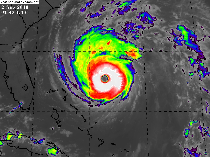
|
A beautiful hurricane!

Higher Resolution Versions: http://rapidfire.sci.gsfc.nasa.gov/gallery/?2010244-0901/Earl.A2010244.1801.2km.jpg
| typhoon_tip |
| (Meteorologist) |
| Wed Sep 01 2010 06:50 PM |
|
|
Well ... we have our selves a real dicey situation up in eastern Long Island, RI and eastern/SE MA.
I have been watching the water vapor imagery over the northwest Atlantic Basin periodically during the day and the ridge prominence in the vicinity is impressive as an anticyclonic lobe is currently pressing ESE toward the lower Maritimes. Enough so to make me want to question the NAM's recent east trend per the 12z and now 18z guidance cycles.
The key is going to be the exact morphology of the of the current closing deep layer vortex over the Great Lakes, and what effect that has on tipping the flow more south to north in orientation in the steering levels along and off the East Coast. The past 48 hours of modeling has unilaterally showed gradually more latitudinal amplitude (not just wind maxes) with that large synoptic evolution, which I believe is pretty strongly related to why we have inched Earl west over time.
That said, Earl seems really on a NNW trajectory to me as of the last 3 hours. We'll see how this holds ... but the last 1 hour "wobble motion" is also pretty clearly due N. The more north component this system gets earlier on, the better off SE New England will be. So this may tentatively be good news farther up the Coast.
NC and VA residence should definitely keep up with on-going preparations relative to advisory status
| Random Chaos |
| (Weather Analyst) |
| Wed Sep 01 2010 06:57 PM |
|
|
|
|
Those of us on the Chesapeake Bay also need to watch.
Western shore of the bay (NWS Sterling):
Quote:
DEPENDING ON HOW CLOSE EARL IS TO THE REGION AND HOW FAST THE STORM IS MOVING WILL DETERMINE TIDAL ANOMALIES. AT THIS POINT...WATER LEVELS ARE EXPECTED TO RANGE FROM 1 TO 3 FEET ABOVE NORMAL DURING TIMES OF HIGH TIDE THURSDAY AND THURSDAY NIGHT. THIS WILL BRING THE POSSIBILITY OF MINOR TO MODERATE TIDAL FLOODING THURSDAY AND THURSDAY NIGHT.
With the Bay's orientation and the storm positioning us in the NW and W quadrants primarily, we can expect significant wave effects. Those with NE or N exposure are most at risk between combined waves and tidal effects.
Most models keep the system far enough offshore that we don't expect major effects, but a few models have trended west over the past couple of runs, so everyone needs to continue watching this along the mid-Atlantic.
| RevUp |
| (Weather Guru) |
| Wed Sep 01 2010 08:13 PM |
|
|
Earl has made a decidedly more northward turn in the last few hours, now moving toward 330 at 18 mph. Good news for the US east coast.
| Random Chaos |
| (Weather Analyst) |
| Wed Sep 01 2010 08:18 PM |
|
|
|
|
Miss Piggy is in the storm.
Eyewall dropsonde:
Surface winds of 113 kts, 951mb surface pressure in the eyewall.
Low altitude winds at 944mb were at 142 kts!
Eye vortex recon:
Surface pressure down to 932mb!
| ftlaudbob |
| (Storm Chaser) |
| Wed Sep 01 2010 08:36 PM |
|
|
|
|
Quote:
Miss Piggy is in the storm.
Eyewall dropsonde:
Surface winds of 113 kts, 951mb surface pressure in the eyewall.
Low altitude winds at 944mb were at 142 kts!
Eye vortex recon:
Surface pressure down to 932mb!
This is getting more serious by the min.Earl is getting stronger.
| MichaelA |
| (Weather Analyst) |
| Wed Sep 01 2010 08:48 PM |

|
|
|
And approaching the Gulf Stream - deep, warm water with lots of heat content. This is not good for the Outer Banks.
|
danielw
|
| (Moderator) |
| Wed Sep 01 2010 08:55 PM |

|
|
|
We had what appeared to be a rather fast moving trough or dry front move through Mississippi this afternoon. I'm not real sure what that might do. ( I think I know, and it's not very good for folks on the Eastern Seaboard.)
I don't recall seeing mention of any fronts passing through here until Thursday or Friday.
Will the shortwave push or pull Earl?
932mb gives a maximum possible windspeed of 143 mph.
The following Model Discussion is a bit old. But worth reading, I think.
MODEL DIAGNOSTIC DISCUSSION
NWS HYDROMETEOROLOGICAL PREDICTION CENTER CAMP SPRINGS MD
221 PM EDT WED SEP 01 2010
VALID SEP 01/1200 UTC THRU SEP 05/0000 UTC
...HURRICANE EARL...
THE 09Z/SREF MEAN...ALONG WITH THE 12Z NAM...12Z/GFS...AND THE
12Z/CMC HAVE TRENDED WEST WITH TRACK OF EARL DURING DAYS 2 AND 3.
THE 12Z/UKMET INDICATES AN EASTWARD TREND COMPARED TO ITS 00Z
RUN...WHILE THE 12Z/ECMWF MAINTAINS A CONSISTENT TRACK. THE SREF
AND NAM INDICATE A SLOWER TREND...WHILE THE GFS HAS TRENDED FASTER
THAN ITS PREVIOUS RUNS. THE MODEL CONSENSUS TAKES THE CENTER
CLOSE TO THE 40N/70W BENCHMARK. THE 12Z/GFS TRACK IS NOTABLY WEST
OF THE MODEL CONSENSUS. SEE THE LATEST ADVISORY FROM THE NATIONAL
HURRICANE CENTER.
| Random Chaos |
| (Weather Analyst) |
| Wed Sep 01 2010 09:02 PM |
|
|
|
|
A 2nd dropsonde, this one in the outgoing eyewall, read 927mb surface pressure / 104kt surface winds. That is 5mb lower than the vortex recon reported the eye being only a few moments earlier. Weird.
Earl is shedding outer convective bands. Generally you only see this when a storm is becoming annular. Everyone needs to watch this storm very closely. Microwave shows no sign of an ERC to weaken the storm anytime soon.
The loss of outer convective bands on the north and west sides can be easily seen on IR: http://www.ssd.noaa.gov/goes/east/nwatl/flash-rb.html
Also, note the close up AVN IR loop: The eye is almost completely cloud free with a very cold eyewall now - http://www.ssd.noaa.gov/goes/flt/t2/flash-avn.html - and also on the water vapor loop - http://www.ssd.noaa.gov/goes/flt/t2/flash-wv.html
| MichaelA |
| (Weather Analyst) |
| Wed Sep 01 2010 09:03 PM |
|
|
|
|
Does this WV loop shed any light on that?
US WV Loop
|
danielw
|
| (Moderator) |
| Wed Sep 01 2010 09:12 PM |
|
|
|
|
Quote:
A 2nd dropsonde, this one in the outgoing eyewall, read 927mb surface pressure / 104kt surface winds. That is 5mb lower than the vortex recon reported the eye being only a few moments earlier. Weird.
Earl is shedding outer convective bands. Generally you only see this when a storm is becoming annular. Everyone needs to watch this storm very closely. Microwave shows no sign of an ERC to weaken the storm anytime soon.
And the second drop was in the western eyewall of a 30nm eye. Did see a note about the eye being open to the south. If Earl closes that opening the pressure will continue to drop and windspeed will increase later tonight.
| Random Chaos |
| (Weather Analyst) |
| Wed Sep 01 2010 09:50 PM |
|
|
|
|
Typhoon Tip said:
Quote:
Well ... we have our selves a real dicey situation up in eastern Long Island, RI and eastern/SE MA.
Taking readings off the spaghetti models from NHC - the bulk of the tracks for the path of the eye fall in the following distances from these locations:
NC - Outer Banks: 10 to 140 miles
NY - Tip of Long Island: 80 to 210 miles
MA - Nantucket Island: 10 to 130 miles
The eye has a radius of around 20 miles. The deep convection surrounding the eye has a radius of around 50 to 80 miles, quadrant dependent.
Everyone along the east coast needs to watch this.
|
MikeC
|
| (Admin) |
| Wed Sep 01 2010 10:19 PM |
|
|
As far as movement, it appears to be stair-stepping, but generally following the forecast track,maybe a tad east.

It looks pretty likely the 11PM Advisory will show higher winds, it may just be under Category 5 strength. It has a shot at becoming annular too, but I'd be surprised if it did.
| Random Chaos |
| (Weather Analyst) |
| Wed Sep 01 2010 10:20 PM |
|
|
|
|
Beautiful IR storm presentation...now if only I were further from its track!
Quick note for people looking for IR images:
SSD is sometimes (not always) running 30 to 60 minutes behind MSFC for releasing IR images. This means for the most recent IR images, head over to MSFC. Their interface is harder to use and does not automatically update the images, so SSD is better for just running a monitoring animation. Not sure how other sites stack up in terms of release intervals.
SSD: http://www.ssd.noaa.gov/PS/TROP/float2.html
MSFC: http://weather.msfc.nasa.gov/GOES/goeseasthurrir.html
|
danielw
|
| (Moderator) |
| Wed Sep 01 2010 11:45 PM |
|
|
|
|
I hope that you are out of reach of the tides there. R.C.
Latest wv imagery loop has Earl on a track between 315 and 320 degrees, or NW.
Using the forecast points, the southern eyewall edge was on the north edge of the 00Z forecast point. Will have to see how well he stays on track at the next point.
Jim cantore signed off at 10 PM tonight and told folks to remember Hurricane Charley. He said be prepared in case it makes a last minute turn like Charley did.
You can bet there is a whole lot of bandwidth in use tonight on the East Coast. And not much sleeping being accomplished.
Mandatory Evacuations begin in parts of NC at 5 AM EDT.
EDited for spelling, etc.
| Random Chaos |
| (Weather Analyst) |
| Wed Sep 01 2010 11:49 PM |
|
|
|
|
I was wondering about that. Land drag is not included into the model guidance and has a large effect on all storms that are near land. Given the size and proximity to land tomorrow, this could affect the course...negatively in my case.
|
danielw
|
| (Moderator) |
| Thu Sep 02 2010 12:05 AM |
|
|
|
|
I looked at the latest SHIPS model and it's only showing 2 kts difference between over water and over land for the next 36 hours. Too much vorticity/ helicity keeping Earl going I guess.
Latest data is showing a 50 mile near miss at Hatteras. That's 50 miles minus the diameter of the eye using the current forecast track.
That's just too close for any comfort.
| ftlaudbob |
| (Storm Chaser) |
| Thu Sep 02 2010 01:43 AM |
|
|
|
|
Earl is looking like a perfect hurricane.Those people in the Carolinas and New England better prepare for a major hurricane.This is very real,and Earl means business.
| Storm Hunter |
| (Veteran Storm Chaser) |
| Thu Sep 02 2010 01:53 AM |

|
|
|
AFR just made a pass from SE to NW... appears Earl might have about 2-3mb lower pressure
|
danielw
|
| (Moderator) |
| Thu Sep 02 2010 01:57 AM |
|
|
|
|
09/02 05:30:30Z 926.4mb (~27.36 inHg)
Topped another record low pressure in the Western Atlantic.
Hurricane Andrew 1992 had 922mb at FL Landfall.
I'm not sure if this NOAA report from earlier will be a record as it's about 1500 feet above the surface. But it's got to be in the top 10 Western Atlantic dropsonde windspeeds:
895mb 60° (from the ENE) 173 knots (199 mph)
| Storm Hunter |
| (Veteran Storm Chaser) |
| Thu Sep 02 2010 02:05 AM |
|
|
|
|
Yeah... thats just amazing!
Here's the dropsonde data!
http://www.tropicalatlantic.com/recon/ar...;product=UZNT13
|
danielw
|
| (Moderator) |
| Thu Sep 02 2010 02:20 AM |
|
|
|
|
Vortex hasn't arrived and no HDOB since 30 minutes ago.
Gulfstream just made a drop by Ed's house. So the data path is good.
AF300 is back online.
ftp showing 37 minutes between HDOBS. Roughride tonight?
Wind center at 05:29:00 28.26N 074.18W 926.4mb wind in eye from SE or 126deg at 005kt
| Storm Hunter |
| (Veteran Storm Chaser) |
| Thu Sep 02 2010 02:35 AM |
|
|
|
|
Last check 5 mins ago, NASA Global hawk just flew over El Palso, TX... enroute to Earl!

|
danielw
|
| (Moderator) |
| Thu Sep 02 2010 02:49 AM |
|
|
|
|
URNT12 KNHC 020605
VORTEX DATA MESSAGE AL072010
A. 02/05:29:00Z
B. 28 deg 26 min N
074 deg 18 min W
C. 700 mb 2494 m
D. 79 kt
E. 136 deg 15 nm
F. 230 deg 125 kt
G. 137 deg 17 nm
H. 931 mb
I. 16 C / 3063 m
J. 21 C / 3054 m
K. 10 C / NA
L. CLOSED WALL
M. C24
N. 12345 / 7
O. 0.02 / 1 nm
P. AF300 1207A EARL OB 06
MAX FL WIND 125 KT SE QUAD 05:24:10Z
MAX OUTBOUND SFC WIND 111 KTS NE QUAD AT 05:31:30 Z
FREQUENT SVR TURBC NW EYEWALL TO 10 NM FURTHER OUT.
So it looks like they are going to keep the 931mb. This was the SE NW leg right?
| Storm Hunter |
| (Veteran Storm Chaser) |
| Thu Sep 02 2010 02:50 AM |
|
|
|
|
2am adv. has
THE MINIMUM CENTRAL PRESSURE JUST EXTRAPOLATED BY AN AIR FORCE
RESERVE HURRICANE HUNTER AIRCRAFT IS 930 MB...27.46 INCHES.
| ftlaudbob |
| (Storm Chaser) |
| Thu Sep 02 2010 02:57 AM |
|
|
|
|
This pressure drop is amazing.Given that and the visible It is safe to say we have a monster on our hands.
| Storm Hunter |
| (Veteran Storm Chaser) |
| Thu Sep 02 2010 02:58 AM |
|
|
|
|
Quote:
So it looks like they are going to keep the 931mb. This was the SE NW leg right?
appears so... plane is coming SW to NE now.. just got to eyewall on SW side.
|
danielw
|
| (Moderator) |
| Thu Sep 02 2010 03:14 AM |
|
|
|
|
Wind center at 07:05:00Z
28.767N 74.567W 924.8 mb(~ 27.31 inHg)
Seems an ERC should be coming up. Earl's been steady state for a while now. I hate that it's someone's monster though.
| Storm Hunter |
| (Veteran Storm Chaser) |
| Thu Sep 02 2010 03:24 AM |
|
|
|
|
Quote:
Wind center at 07:05:00Z
28.767N 74.567W 924.8 mb(~ 27.31 inHg)
Seems an ERC should be coming up. Earl's been steady state for a while now. I hate that it's someone's monster though.
Well his width of eye was 30 miles yesterday evening... now down to 24 after 2am... so it may take a few more hours for the ERC to begin i would think?
| Storm Hunter |
| (Veteran Storm Chaser) |
| Thu Sep 02 2010 03:38 AM |
|
|
|
|
Product: Air Force Vortex Message (URNT12 KNHC)
Transmitted: 2nd day of the month at 07:30Z
Aircraft: Air Force Aircraft (Last 3 digits of the tail number are 300)
Storm Number & Year: 07L in 2010
Storm Name: Earl (flight in the North Atlantic basin)
Mission Number: 12
Observation Number: 10
A. Time of Center Fix: 2nd day of the month at 7:05:40Z
B. Center Fix Coordinates: 28°47'N 74°32'W (28.7833N 74.5333W)
B. Center Fix Location: 310 miles (499 km) to the NE (34°) from Nassau, Bahamas.
C. Minimum Height at Standard Level: 2,488m (8,163ft) at 700mb
D. Estimated (by SFMR or visually) Maximum Surface Wind: 104kts (~ 119.7mph)
E. Location of the Estimated Maximum Surface Wind: 6 nautical miles (7 statute miles) to the WSW (245°) of center fix
F. Maximum Flight Level Wind Inbound: From 333° at 111kts (From the NNW at ~ 127.7mph)
G. Location of Maximum Flight Level Wind Inbound: 8 nautical miles (9 statute miles) to the WSW (243°) of center fix
H. Minimum Sea Level Pressure: 929mb (27.43 inHg)
I. Maximum Flight Level Temp & Pressure Altitude Outside Eye: 11°C (52°F) at a pressure alt. of 3,051m (10,010ft)
J. Maximum Flight Level Temp & Pressure Altitude Inside Eye: 22°C (72°F) at a pressure alt. of 3,057m (10,030ft)
K. Dewpoint Temp (collected at same location as temp inside eye): 10°C (50°F)
K. Sea Surface Temp (collected at same location as temp inside eye): Not Available
L. Eye Character: Closed Wall
M. Eye Shape: Elliptical (oval shaped)
M. Orientation of Major Axis in Elliptical Eye: 340° to 160° (NNW to SSE)
M. Length of Major Axis in Elliptical Eye: 32 nautical miles (37 statute miles)
M. Length of Minor Axis in Elliptical Eye: 22 nautical miles (25 statute miles)
N. Fix Determined By: Penetration, Radar, Wind, Pressure and Temperature
N. Fix Level: 700mb
O. Navigation Fix Accuracy: 0.02 nautical miles
O. Meteorological Accuracy: 1 nautical mile
Remarks Section - Remarks That Were Decoded...
Maximum Wind Outbound: 141kts (~ 162.3mph) in the northeast quadrant at 7:10:50Z
Maximum Flight Level Wind: 141kts (~ 162.3mph) in the northeast quadrant at 7:10:50Z
Maximum Surface (likely estimated by SFMR) Wind Outbound: 117kts (~ 134.6mph) in the northwest quadrant at 7:10:10Z
Remarks Section - Additional Remarks...
INFRQT MDT TURBC SW AND NE EYEWALLS
| Storm Hunter |
| (Veteran Storm Chaser) |
| Thu Sep 02 2010 03:46 AM |
|
|
|
|
Quote:Quote:
So it looks like they are going to keep the 931mb. This was the SE NW leg right?
appears so... plane is coming SW to NE now.. just got to eyewall on SW side.
dropsonde on the first pass had 931mb (27.49 inHg) Sea Level (Surface)Air Temp. 26.8°C (80.2°F) Dew Point 25.9°C (78.6°F)180° (from the S) 18 knots (21 mph) so they may have done a 1 mb reduction with 20 mph surface speed?
| Storm Hunter |
| (Veteran Storm Chaser) |
| Thu Sep 02 2010 04:00 AM |
|
|
|
|
dropsonde data from NE eyewall... amazing data
Mission Number: 12
Observation Number: 12
http://tropicalatlantic.com/recon/archiv...&mission=12
Level:::: Wind Direction :::: Wind Speed
943mb (Surface) 70° (from the ENE) 118 knots (136 mph)
941mb 70° (from the ENE) 118 knots (136 mph)
935mb 70° (from the ENE) 136 knots (157 mph)
929mb 75° (from the ENE) 134 knots (154 mph)
922mb 75° (from the ENE) 147 knots (169 mph)
917mb 80° (from the E) 140 knots (161 mph)
910mb 80° (from the E) 146 knots (168 mph)
904mb 85° (from the E) 138 knots (159 mph)
890mb 90° (from the E) 134 knots (154 mph)
877mb 95° (from the E) 141 knots (162 mph)
867mb 95° (from the E) 138 knots (159 mph)
859mb 100° (from the E) 147 knots (169 mph)
850mb 100° (from the E) 141 knots (162 mph) Geo. Height::: 913m (2,995 ft)
816mb 115° (from the ESE) 153 knots (176 mph)
780mb 130° (from the SE) 135 knots (155 mph)
696mb 145° (from the SE) 135 knots (155 mph)
basically just over 500 ft above surface... 155-160MPH WINDS!
not sure if i did my math right.. its late... haha...
Release Location: 28.97N 74.28W
Release Time: 7:10:29Z
Splash Location: 29.04N 74.44W
Splash Time: 7:15:00Z
would that mean the dropsonde traveled over 10 miles from release to splash?
| Random Chaos |
| (Weather Analyst) |
| Thu Sep 02 2010 06:30 AM |
|
|
|
|
5am NHC:
Officially a 125kt storm.
Since then as a hole has developed outside the eye on IR. It appears an ERC is underway. Waiting on vortex recon to confirm, but it is slow coming in.
SFMW indicates hurricane force winds extend out nearly 70 miles in the NE quadrant.
Storm Hunter: 10.8 miles, actually. Wolfram Alpha is great
NE eyewall drop just now traveled 11 miles.
|
MikeC
|
| (Admin) |
| Thu Sep 02 2010 06:54 AM |
|
|
Earl's now beginning to show up on Radar from WIlmington.
| Ed in Va |
| (Weather Master) |
| Thu Sep 02 2010 09:07 AM |
|
|
If radar is any indication, looks like that front has stalled, which is not a good sign for the OBX.
http://www.intellicast.com/National/Radar/Current.aspx?animate=true&location=default
| doug |
| (Weather Analyst) |
| Thu Sep 02 2010 10:16 AM |
|
|
My guess is, looking at the WV, the point for Earl to turn NE is about the Delmarva. The trough is not making much push on its south, but is continuing to progress on the north. However the motion on Earl now is certainly more consistent with NNW. The ridge seems to be digging in behind Earl's wake from the NE which should push Earl more northward until the point where he feels the trough. The whole visual picture confirms the best case scenario under the circumstances, for the OBX, that Earl will remain offshore. But a turn to the NE that far north does not bode well for the NE coastliine which is where I think the real danger for a land fall exists.
| sailor |
| (Verified CFHC User) |
| Thu Sep 02 2010 11:26 AM |
|
|
Hurricane Warning just went up at 11 AM here just west of the Cape Cod Canal. Agree a late turn to the North would be a real problem here. We may be dealing with a Edna(1954) track just East of us.
http://www.erh.noaa.gov/box/hurricane/hurricaneEdna.shtml
http://commons.wikimedia.org/wiki/File:Edna_1954_map.png
Bob
Survived Carol, Edna, Gloria and Bob (boat didn't !)
| LoisCane |
| (Veteran Storm Chaser) |
| Thu Sep 02 2010 01:03 PM |

|
|
|
That front is moving very slowly. It will move but I don't think it's moving as fast as the models had figured. I had heard somewhere ....and sorry don't remember which email .... that the models were not handling the size and intensity of Earl. I am not sure what that means but any deviation extrapolated over time is serious.
Also, dynamics within the structure of the eyewall and inner bands has changed the size of the Storm and the size (not strength) is expanding, almost from my perspective in anticipation of when it will go extratropical and merge with the front... also a higher lat signature.
On the left side of the storm there is a strong band of strong hurricane force winds far from the center and every mile it stays east of OBX will make a big difference in dollar amount and time to recover from any effects.
Can look on any loop and see that front is moving very slowly.
| mwillis |
| (Weather Hobbyist) |
| Thu Sep 02 2010 01:23 PM |
|
|
|
|
Wow hes a big storm, wonder why the convection (white clouds) is so concentrated to the south east side of the center?
http://weather.msfc.nasa.gov/GOES/goeseasthurrir.html
If you select animation and 6 frames then click on the hurricane it will loop a close up, on link above you can she he is going mostly north with a slight shift west on the last few frames
 NHC has on their 2pm discussion that earl is moving north, however if you look at sat. pictures above, you can see that it has moved nnw, too on the last few frames. Why no mention of this?
| k___g |
| (Weather Guru) |
| Thu Sep 02 2010 01:38 PM |

|
|
|
Appears that the eye is filling in and a mostly north track has begun. Good news for the outer banks but it will be close. They will get a good blow.
| Storm Hunter |
| (Veteran Storm Chaser) |
| Thu Sep 02 2010 02:08 PM |
| Attachment |
|
|
|
|
wonder what Earl looked like at sunrise this morning, From 60kft? Check out the cam from NASA's Global Hawk... aka UAV
http://www.nasa.gov/images/content/479615main_20100902_EARL-GH_full.jpg
Also the DC-8 just flew under the Global Hawk tracking NW
| mwillis |
| (Weather Hobbyist) |
| Thu Sep 02 2010 02:22 PM |
|
|
|
|
http://weather.msfc.nasa.gov/GOES/goeseasthurrir.html
Earl is still moving north with a west shift, he just past 75n, which the track projection has him riding up the 75n long line. whether this is a temp shift west only to come back east later is unknown.
This is my opinion from what i see, any thoughts?
| hogrunr |
| (Weather Guru) |
| Thu Sep 02 2010 02:25 PM |
|
|
|
|
At the 11AM update, recon found Earl to be at 75.1W and the 2PM update he was 75.2W. The NHC is stating the motion is 355 degrees, just very very slightly west of due North. I believe they have it spot on.
| mwillis |
| (Weather Hobbyist) |
| Thu Sep 02 2010 02:29 PM |
|
|
|
|
Quote:
At the 11AM update, recon found Earl to be at 75.1W and the 2PM update he was 75.2W. The NHC is stating the motion is 355 degrees, just very very slightly west of due North. I believe they have it spot on.
oh ok, cause accoring to nasa/msfc, they have earl at 31.30 deg n and 75.52 deg west as of the 17:45 utc image
http://weather.msfc.nasa.gov/GOES/goeseasthurrir.html
Thats weird as soon as i posted this i went back to the site and the location of 75.52 deg w changed to 74.83 deg w in less than 2 minutes, lol
|
MikeC
|
| (Admin) |
| Thu Sep 02 2010 02:51 PM |
|
|
The Eye of Earl is covered up again, and the core isn't quite visible on long range radar, which makes it more difficult to tell, but I sincerely hope it begins a more due north/nne motion soon or it will make a direct landfall on the outer banks.
.. Although it appears to be heading more northerly now.
| Beaumont, TX |
| (Storm Tracker) |
| Thu Sep 02 2010 03:31 PM |
|
|
Seeing what you are seeing. Hope he turns to the northeast soon.
| mwillis |
| (Weather Hobbyist) |
| Thu Sep 02 2010 03:32 PM |
|
|
|
|
Quote:
The Eye of Earl is covered up again, and the core isn't quite visible on long range radar, which makes it more difficult to tell, but I sincerely hope it begins a more due north/nne motion soon or it will make a direct landfall on the outer banks.
.. Although it appears to be heading more northerly now.
I noticed that 2 images one from hurricane floater and 1 from nasa has slightly different center positions, yet the time index on both images are the same 18:45 utc.. confusing to me
http://www.ssd.noaa.gov/goes/flt/t2/wv-l.jpg
http://weather.msfc.nasa.gov/GOES/goeseasthurrir.html
with this image just click on the storm itself for close up
|
MikeC
|
| (Admin) |
| Thu Sep 02 2010 03:36 PM |
|
|
The center is starting to be visible on radar now:
http://flhurricane.com/imageanimator.php?85
Longer term Radar recording, hopefully it'll make the trends easier to spot.
| k___g |
| (Weather Guru) |
| Thu Sep 02 2010 03:40 PM |
|
|
|
|
It has begun that N-NE trend and has been for awhile. The outer banks should still get a stiff wind.
| k___g |
| (Weather Guru) |
| Thu Sep 02 2010 04:48 PM |
|
|
|
|
Kudos to the NHC!!!

|
Ed Dunham
|
| (Former Meteorologist & CFHC Forum Moderator (Ed Passed Away on May 14, 2017)) |
| Thu Sep 02 2010 05:33 PM |
|
|
Just a reminder from the Site Rules:
"Low Content Posts: Please do not make single line posts containing no content (ie, "Thanks!" "Great Post" "Cool!", "I agree", or something else completely void of meaning). Or general cheerleading, for example, if you think someone did a good job and have nothing else to add send them a PM, it works better for this. We appreciate the thanks, but otherwise posts like these just litter up the forums."
Thanks for your help with this.
ED
| syfr |
| (Verified CFHC User) |
| Thu Sep 02 2010 06:40 PM |

|
|
|
Whoops, this is a live link, and the storm will disappear as it progresses.

| Random Chaos |
| (Weather Analyst) |
| Thu Sep 02 2010 07:43 PM |
|
|
|
|
Today's beauty shot - 3:30 PM EST
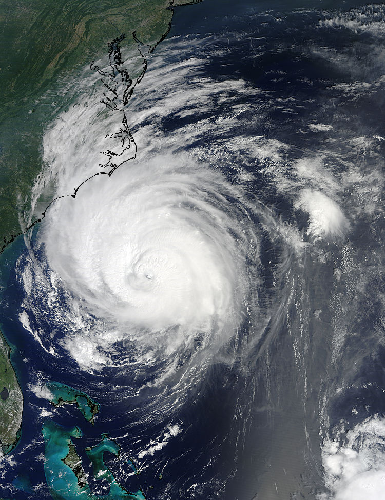
Higher res versions: http://rapidfire.sci.gsfc.nasa.gov/gallery/?2010245-0902/Earl.A2010245.1529.2km.jpg
| Storm Hunter |
| (Veteran Storm Chaser) |
| Fri Sep 03 2010 01:09 AM |
|
|
|
|
Pretty picture above. If you take a look at the flhurricane radar images being recorded from MHX... You can clearly see IMO the vertical shear that started affecting Earl today. Run the loop faster then normal and look at the SW side of the storm... check out how theres a low level banding on the SW that doesn't match up with the wider echos on the west side of coc. The lower bands are spinning faster in, but don't match up with the coc as the storms moves NNE. Granted i know the earth is round and the beam from radar is shooting out... Makes it harder to explain, so maybe it may be easier for you to just take a look?
http://flhurricane.com/imageanimator.php?85
**just speed up loop after it loads... and watch the feeder bands on sw and west side***
Its pretty neat to see what appears to me to be a mid level jet (area of winds/dry air?) begin to disrupt the SW side of coc.
**see the a short video from Monday of Earl from the DC-8... note the flexing of wings in the eyewall at 38kft and the vortices in the eye... storm was north of Island Monday**
http://www.youtube.com/watch?v=dGnbfoN1vdg
**NASA's version*** http://www.youtube.com/watch?v=QyiI38FWU74
|
danielw
|
| (Moderator) |
| Fri Sep 03 2010 09:16 AM |
|
|
|
|
Test post
Test successful
 --Tom
--Tom
|
MikeC
|
| (Admin) |
| Fri Sep 03 2010 05:36 PM |
|
|
To anyone from eastern North Carolina, how was Earl for your area? I'm glad another system has re curved before landfall.
|
danielw
|
| (Moderator) |
| Sat Sep 04 2010 08:28 AM |
|
|
|
|
The remnants of XTS Gaston are looking mighty impressive this morning. Latest visible satellite image below. Nearly all of the current models forecast a track along the Greater Antilles, similar, but to the south of Earl's track.

| WesnWylie |
| (Weather Guru) |
| Sat Sep 04 2010 06:02 PM |
|
|
The disturbance in the Bay of Campeche continues to organize late this afternoon. I think that this area is definitely something to watch, especially tomorrow, as it head northwest. I have a feeling that the NHC will increase its chance to 40% this evening since it appears to be in a decent area for development.
| CarolinaGurl |
| (Weather Watcher) |
| Sat Sep 04 2010 09:07 PM |

|
|
|
Here in Wilmington Earl was a non event except for the rip currents. It was a little breezy but not bad at all and no rain, which we needed.
| OrlandoDan |
| (Weather Master) |
| Sun Sep 05 2010 08:47 AM |

|
|
|
Gaston has a nice burst of convection this morning. This one obviously warrants watching. I notice that the models refelct this moving on a fairy westward direction. I would not be surprised to see a more northerly component start to surface in the near future.
| WesnWylie |
| (Weather Guru) |
| Sun Sep 05 2010 10:48 AM |
|
|
90L is looking really good this morning. I think that the actual center is west of where the models show which would give it some more time to organize/strengthen. I have a feeling this will become a tropical depression by this afternoon.
| syfr |
| (Verified CFHC User) |
| Sun Sep 05 2010 07:56 PM |
|
|
|
|
I'm on Ocracoke Island, and tho Earl was quite close to here and many people evacuated, the island took very very little damage. More than anything, it dumped a lot of rain, a few shingles are off some roofs and a few docks were damaged.. Today, the ocean was almost millpond smooth.