MikeC
|
| (Admin) |
| Wed Sep 08 2010 04:11 PM |
|
|
Hurricane Julia was upgraded to a category 4 hurricane overnight, joining Hurricane Igor, meaning there are two category four storms active in the Atlantic at the same time. Bermuda should continue to monitor Igor very closely. Julia is out to sea, and it's likely anything else coming off from the cape verde this year will recurve.
This means in 2010 that so far there have been 4 major hurricanes, and all of the majors have made it to category four.
Tropical Storm Karl is strengthening as it is making landfall in the Yucatan. The official forecast has it restrengthening in the Bay of Campeche and becoming a hurricane before landfall near or just south of Tampico in Mexico. Those in the area will want to watch it closely.
It's now mid september and focus will be less on the Cape Verde systems, and more on the Caribbean and Gulf and closer Atlantic waters. The most likely spot for development next week will likely be in the Caribbean.

{{StormCarib}}
{{StormLinks|Igor|11|11|2010|1|Igor}}
{{StormLinks|Julia|12|12|2010|3|Julia}}
{{StormLinks|Karl|13|13|2010|2|Karl}}
9:00PM EDT Updated - Tuesday, 14 Sept 2010
Tropical Storm Karl has formed in the Western Caribbean and is forecast to make landfall along the Yucatan peninsula tomorrow as a tropical storm. After which it is forecast to move into land near Tampico in Mexico as a Tropical Storm. Thankfully conditions appear it won't be much more than rainfall.
Igor is still a category 4 hurricane and the forecast track should keep Bermuda watching it closely, the forecast track for it seems fairly good.
Julia should remain well out to sea.
Three storms in the Atlantic, one a threat to Mexico for mostly rainfall, one a potential threat to Bermuda, and another no threat to land at all. None of the systems appear to be a threat to the United States.
3:45PM EDT Updated - Tuesday, 14 Sept 2010
Just a quick update to note that Tropical Storm Karl has formed in the Caribbean as found by Recon.
1:30PM EDT Updated - Tuesday, 14 Sept 2010
As two impressive hurricanes continue spinning far out to sea, a bit of a sneaker of a system which we have been following (Invest 92L) is now developing impressively in the favorable environment of the west-central Caribbean, and if current trends continue, advisories could very easily and quickly be issued for west Caribbean nations and/or their nearby islands later today or tonight. Interests in and around the western Caribbean, including the Yucatan peninsula, may want to start taking some tentative precautions for very heavy rain and stout wind, regardless.
Recon is currently back en route to Invest 92L.
7AM EDT Update - Tuesday, 14 Sept 2010
Igor has weakened a bit overnight, but not all that much, it is still a Category 4 hurricane. The expected turn to the north has begun, and it appears the Leewards will be spared the worst. Igor may get very close to Bermuda, it likely will be weaker near there, but it would still be a formidable hurricane. Those in Bermuda will want to watch very closely over the next several days.
Julia is now a Hurricane, as is already well on it's way to recurving.
The wave in the Caribbean (92L) had a bit too much land interaction and chances have dropped for its development but probably will rebound by the afternoon. It still is fairly likely to form before landfall in the Yucatan.
It is possible for a few more waves off Africa to develop, but recurves are most likely in any of the scenarios for another week or so. As the season goes deeper into the second half, more focus will be shifted westward.
12AM EDT Update - Monday, 13 Sept 2010
At 13/03Z NHC upgraded TD12 to Tropical Storm Julia - the tenth named storm of the season. Julia was located about 110 miles to the southeast of the southern Cape Verde Islands and with movement to the west northwest becoming more northwest at 10mph, a Tropical Storm Warning has been issued for those southern islands. Julia is expected to become a Hurricane on Tuesday. Wih some factors favoring an increase in intensity and increasing windshear and cooler SSTs in a couple of days favoring a decrease in intensity, the intensity forecast beyond Tuesday could see some fluctuations.

Igor is...well, simply an amazing storm with sustained Cat IV winds now at 130 knots and the possibility of 140 knots (Cat V) by 12Z on Monday. Although some erosion has been noted on the southeast core, this could simply be associated with the directional change of the past few hours to slightly south of due west, and there is a pocket of drier air ahead of the system for the next couple of days but its not that significant. Near-term motion to the west and west northwest is anticipated, however, the long term is still a bit uncertain with a few models hinting at a turn back toward the west northwest, i.e., the weakness in the ridge does not fully capture the system. However, at the moment this is still an outlier scenario - but folks in the northern Leeward Islands should closely monitor Igor and wait for the expected turn to the northwest.
Invest 92L is located south of the western tip of Haiti moving slowly to the west northwest and Jamaica can anticipate heavy rain squalls on Monday. The system is very disorganized and shows no sign of near-term development.
ED
{
7:00PM EDT Update Sunday, 12 September 2010
Hurricane Igor has strengthened into a Category 4 hurricane today, and may strengthen a bit more before weakening. Odds continue to favor it recuring before nearing land, but it will have to be monitored to see if anything changes.

The wave in the Caribbean (92L) is bringing some rainfall into Haiti now, if it develops it won't be for another day or so.
9:00AM EDT Update Sunday, 12 September 2010
Hurricane Igor continues to look impressive on Satellite and is moving generally westward at about 18MPH. The current forecast track keeps the cone northeast of the Leeward islands, but those there should continue to watch until the northward movement verifies. Odds currently favor Igor recurving before the Islands. Beyond that, odds favor recurve before reaching the us, but trends may move it westward, and another "Earl-Like" situation could develop. However, odds are it will stay offshore.
The wave in the Central Caribbean (92l) stil has a 50/50 shot of development over the next two days, it becomes more likely as it nears the western Caribbean. Once there those in the Yucatan, and westward into Southern Mexico will want to watch it.
The system off Africa, 93L, has formed into Tropical Depression 12, and advisories will likely start at 11AM EDT this morning. Odds are extremely high this too will recurve out to sea.
8:30AM EDT Update Saturday, 11 September 2010
This morning there is Tropical Storm #Igor, now on the verge of becoming a hurricane. Igor's odds still favor out to sea currently, but the Leeward islands will want to watch since they are in the cone. It would approach the islands until Thursday or Friday if it did.
The wave in the Caribbean (92L) still has a shot to develop before the end of the weekend (60% now), so those in Jamaica, Caymans, CUba, and the Yucatan Peninsula including Belize will want to continue watching it. Odds favor it remaining generally west and south so it may be a threat for other parts of Mexico later as well.
93L is a wave that has just come off the coast of Africa, and already has a good pattern to allow it for development into a tropical depression or storm, odds favor this going out to sea as well, but there are several opportunities where that could change. It currently has a 30% chance to develop within the next two days.
6PM EDT Update Friday, 10 September 2010
Not too much has changed since yesterday on Igor and 92L. Igor has regained some strength and has a good shot to become a major later on, but still looks like odds favor it staying out to sea. Still a lot of time for things to change, however.
92L is about a 50/50 for development over the weekend, and it's still is worth watching for Western Caribbean Islands and the Yucatan, and odds favor it staying south, but again it's worth watching for changes.
{{StormCarib}}
Flhurricane recording of French Atilles Radar for 92L
7AM EDT Update Thursday, 9 September 2010
Igor is not moving, and at this far out in the Atlantic it's likely to cause a very long delay before it heads more west, it has remained weak as well. The official forecast keeps it still in the Central Atlantic into the middle of next week. Odds strongly favor the system staying out to sea once past the Cape Verde, and it may become a major hurricane while doing so.
Outside of this, Ex-Gaston is over Hispaniola and is causing rains in Haiti, but does not look to develop anytime soon. Another area in the Leeward islands may have to be watched as it moves westward, but for now it's not an official "Invest" area. (Update: Just minutes after this was written, 92L gets designated) This system has a good shot for development when this system arrives in the western Caribbean, and is probably the most worthy of being watched of all the areas (For affects to land. m Highest chances currently are for western Caribbean islands (Caymans/Jamaica/Cuba), Belize, Yucatan, and Mexico westward). Although for track it is still a developing system, so things can change.
If it were to develop, Saturday/Sunday seems to be most likely.
Over Africa another wave may emerge that could develop, but that also is trending toward a recurve.
In short, one storm that looks to recurve, and a few unlikely areas that need to be watched for development later is pretty good news for the peak of the season. However, this is also the time to watch for surprises (like Hermine).
Original Update
Tropical Storm Warnings are up for the Cape Verde islands off Africa as Tropical Storm Igor forms in the Eastern Atlantic.
It is forecast to move westward and strengthen into a hurricane. Odds slightly favor Igor staying out to sea, but long range uncertainties make it worth watching through the week into next.
This is going to take a while to cross the Atlantic-- any affects on the Caribbean islands would not be seen until late next week.
More to come later.
| stormtiger |
| (Weather Hobbyist) |
| Wed Sep 08 2010 05:56 PM |
|
|
On Sept. 5th Mr. Dunham wrote a nice piece on how it looked like conditions were that we might hit a lull during the peek of what was forecasted to be a busy season.
Since his blog, we have had two named storms and it's just Sept. 8th.
Early in June and July many of us felt we were on the verge of having several tropical systems to track; however, only one in June and one in July came to fruition. It seemed no matter how warm the waters were and how light the sheer was, it was hard to get things to pop.
Now we see the opposite in a sense. conditions aren't ideal, but a system in the GOM took off quickly, and one in the Far East Atlantic just became Igor. It seems climatology is a huge factor.
So much for the lull.
Let's hope the season continues as we've seen and all the major storms follow the central Atlantic path.
| Jasonch |
| (Weather Watcher) |
| Wed Sep 08 2010 06:03 PM |
|
|
This probably will be another fish storm.
| Storm Hunter |
| (Veteran Storm Chaser) |
| Wed Sep 08 2010 06:06 PM |

|
|
|
long range Euro is looking interesting... takes Igor into a deep tropical cyclone as he passes north of Islands.... Model has done pretty good with this coming off of Africa
| Jasonch |
| (Weather Watcher) |
| Wed Sep 08 2010 06:15 PM |
|
|
Quote:Isn't it funny some people seem to think they have it all figured out. The conditions are perfect ( no wind shear, warm water) and then the second something forms and it has a hard time getting going then that is when they realized the conditions weren't so perfect. Nobody has a clue what the conditions are until the storm is out there. Gaston was a perfect example of that.
On Sept. 5th Mr. Dunham wrote a nice piece on how it looked like conditions were that we might hit a lull during the peek of what was forecasted to be a busy season.
Since his blog, we have had two named storms and it's just Sept. 8th.
Early in June and July many of us felt we were on the verge of having several tropical systems to track; however, only one in June and one in July came to fruition. It seemed no matter how warm the waters were and how light the sheer was, it was hard to get things to pop.
Now we see the opposite in a sense. conditions aren't ideal, but a system in the GOM took off quickly, and one in the Far East Atlantic just became Igor. It seems climatology is a huge factor.
So much for the lull.
Let's hope the season continues as we've seen and all the major storms follow the central Atlantic path.
|
Ed Dunham
|
| (Former Meteorologist & CFHC Forum Moderator (Ed Passed Away on May 14, 2017)) |
| Wed Sep 08 2010 07:47 PM |
|
|
For clarification, suggest that you might want to re-read the entire article. While I did mention the possibility that the peak of the season might be quiet (with Igor that no longer is true), I think that I may have mentioned something about activity in the southwest GOM and something about a wave that would exit Africa in two or three days.
Because Meteorology is the youngest of the natural sciences and therefore far from an exact science, we offer the Forecast Lounge for you to offer your thoughts - without retribution.
The intent of the Blog was not to imply that there would not be further storms this season - but it seems that I must have left that impression - which was not intended. Climatology expresses something in averages - and extremes.
ED
| rgd |
| (Weather Hobbyist) |
| Wed Sep 08 2010 11:00 PM |
|
|
Quote:
long range Euro is looking interesting... takes Igor into a deep tropical cyclone as he passes north of Islands.... Model has done pretty good with this coming off of Africa
Yup looking that way.Some are trying to pull straws and find different but it looks like another fishy
| berrywr |
| (Weather Analyst) |
| Thu Sep 09 2010 03:05 AM |

|
|
|
Models have done pretty darn good all season! Let me see, 24 degrees W; what's that...3 weeks to reach 80 degrees W at 7 mph? What to do...what to do...
| bobbutts |
| (Weather Hobbyist) |
| Thu Sep 09 2010 04:09 PM |

|
|
|
oops, mentioned 92L but it's already in the news item.
If this system develops, it's in a location where it would be very difficult to find a track that doesn't affect land.
|
MikeC
|
| (Admin) |
| Thu Sep 09 2010 11:11 PM |
|
|
Site Note: Our primary image server is down at the moment, so some images may not appear.
| ftlaudbob |
| (Storm Chaser) |
| Fri Sep 10 2010 08:19 PM |
|
|
|
|
Igor is back to TS status and looking rather well.Still too early to tell if he will re curve or continue west.There doesn't seem to be of much interest in here yet,but that could change by next week.
|
MikeC
|
| (Admin) |
| Fri Sep 10 2010 10:03 PM |
|
|
Not too much has changed since yesterday on Igor and 92L. Igor has regained some strength and has a good shot to become a major later on, but still looks like odds favor it staying out to sea. Still a lot of time for things to change, however.
92L is about a 50/50 for development over the weekend, and it's still is worth watching for Western Caribbean Islands and the Yucatan, and odds favor it staying south, but again it's worth watching for changes.
The ZImmerman fhurricane image server is still down at the moment, but I've rewired part of it to use alternates, and more images should begin to appear over time.
| typhoon_tip |
| (Meteorologist) |
| Fri Sep 10 2010 10:50 PM |
|
|
Igor:
If I didn't know any better I'd see we just recently have a center relocation closer into a suddenly very symmetrical looking system, replete with at least a quasi-CDO feature. This is taking place across the last hour and currently.
|
Ed Dunham
|
| (Former Meteorologist & CFHC Forum Moderator (Ed Passed Away on May 14, 2017)) |
| Fri Sep 10 2010 11:09 PM |
|
|
It was really difficult to know for sure - having to deal with IR imagery, but it looked to me like the center was realigning a little more under the convection. Perhaps near 17N 34W. The easterly shear certainly is declining.
ED
| typhoon_tip |
| (Meteorologist) |
| Fri Sep 10 2010 11:24 PM |
|
|
Guidance continues to shift westward with the track of Igor, including this most recent run of the GFS as of 18z. It is important to note that forecast errors expand to as much as 300 miles by Day 5. This implies that the people in the northern Leeward Islands should at least begin monitoring the progress of Igor, and the official forecasts for their area over the next 5 days.
| typhoon_tip |
| (Meteorologist) |
| Fri Sep 10 2010 11:59 PM |
|
|
Outflow in the cirrus field is improving dramatically as the evening presses onwards. The wind overlays at TPC even support a few vectors that are opposing the shear from earlier in the day. Given the apparent repositioning (and we await the final say from upstairs) combined with this intense IR show intensifying with a bit more certitude is likely underway.
| berrywr |
| (Weather Analyst) |
| Sat Sep 11 2010 01:07 AM |
|
|
|
|
Good evening...Igor finally has gotten his wings and is on the move west. We have about a 5 day window before we're going to know whether recurvature lies in Igor's future.
For the moment the models beyond 5 days have Igor approaching a COL between two ridges and a shortwave to the north at 30.0N and 73.0W. Igor will slow and spend a few days in this vicinity if the models verify and has a future date being caught up in the westerlies.
There is model difference as expected in the longer ranges and all are focused on the strength of the subtropical ridge in the Atlantic.
Turning to the wave in the Caribbean; the models take this feature west and emerge it over the Pacific in five days.
I'm aware there is a wave expected to develop and trail Igor but it's way too early to speculate since this wave is over Africa as of this typing.
| RevUp |
| (Weather Guru) |
| Sat Sep 11 2010 12:00 PM |
|
|
92L is looking much more favorable for further development and classification this morning ... showers on the increase toward PR-VI and sfc pressures lower.
42060 5-day mslp plot
| typhoon_tip |
| (Meteorologist) |
| Sat Sep 11 2010 04:09 PM |
|
|
Shortly after Igor's improved display during the overnight he began ingesting SAL contaminant as can be seen here:
http://cimss.ssec.wisc.edu/tropic/real-time/wavetrak/winds/m8split.html
This will likely impeded much further intensification in the shorter terms, but should not prove to end Igor by any means. This is not a major hindrance looking out in time as we can see this is a single arcing band that has gotten caught up in Igor's large circulation field. Every system (Danielle, Earl...etc) thus far this season demonstrated a weakening trend when passing Igor's current latitude/longitude, and in each case SAL material was present and could be seen using this product to be ingesting into the systems.
92L:
...Has a much improve satellite performance this morning and NHC feels pretty strongly that a depression will be forming here imminently.
Guidance is spread ... ranging from not seeing much of anything even there, to moving toward the PR archipelago, to a Caribbean Cruiser eventually terrorizing the western ends of the region. It is not likely the models will be in much consensus until a real entity shows up better in the initializations.
| berrywr |
| (Weather Analyst) |
| Sat Sep 11 2010 06:27 PM |
|
|
|
|
Thanks Tip! I looked at everything you just wrote about and I'll add this one other tidbit...there is also quite a bit of dry and subsidence air entraining into the system from the west and north confirming your SAL analysis; however the SAL isn't as strong as previous systems and it will be short lived as Igor tracks west.
| typhoon_tip |
| (Meteorologist) |
| Sat Sep 11 2010 10:48 PM |
|
|
It is quite likely that Igor will be upgraded to a hurricane upon the 8pm advisory. Microwave imagery over the 1 to 1.5 hours give clear indication of a eye wall structure over the west south and east semicircles, with true centroid axis of rotation collocated. The wind was in the process of differentiating higher per the last frame over 60kts at this point.
| WesnWylie |
| (Weather Guru) |
| Sun Sep 12 2010 01:27 AM |
|
|
Well, after 92L died down earlier this evening, it appears that some more convection is firing up close to the center. I think this will likely develop into a tropical depression sometime tomorrow.
| Random Chaos |
| (Weather Analyst) |
| Sun Sep 12 2010 05:16 AM |

|
|
|
As of 11:20pm, Igor is now a Category 1 hurricane.
Additionally, as of 11:20pm, the eastern Atlantic storm has been raised to 90% chance of development.
NHC: "SPECIAL OUTLOOK ISSUED TO RAISE DEVELOPMENT CHANCE FOR SYSTEM IN THE EASTERN ATLANTIC AND TO INDICATE IGOR AS A HURRICANE NOT A TROPICAL STORM..."
Full text:
http://www.nhc.noaa.gov/text/refresh/MIATWOAT+shtml/120319.shtml
|
danielw
|
| (Moderator) |
| Sun Sep 12 2010 03:21 PM |

|
|
|
From right to left it's quite busy for Mid Season.
TD12 over the Cape Verde Islands.
Cat 2 Hurricane Igor with sustained winds of 105 mph.
Area in Central Caribbean Sea still being watched.
Area of disturbed weather over the Bay of Campeche'.
IR satellite photo taken at 1415Z or 1015 EDT.

Nearly perfect spacing of the three systems being watched in the Atlantic. Notice how the cloud streets feed from the top of one system into the bottom of the next system.

©2002-2010 Texas Commission on Environmental Quality
| WeatherNut |
| (Weather Master) |
| Sun Sep 12 2010 06:51 PM |
|
|
special weather statement from NHC...Igor is now Cat4 w/ 135mph winds and has been rapidly intensifying
| Random Chaos |
| (Weather Analyst) |
| Sun Sep 12 2010 08:24 PM |
|
|
|
|
Igor is beautiful!
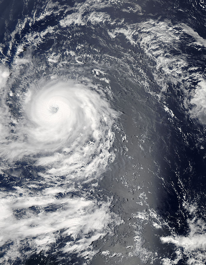
Source and higher resolution images
|
MikeC
|
| (Admin) |
| Sun Sep 12 2010 08:56 PM |
|
|
Site Note: flhurricane will be down for 30 min to an hour for a hardware fix between 5:30-7PM, and should be back up hopefully fairly soon.
|
danielw
|
| (Moderator) |
| Sun Sep 12 2010 09:25 PM |
|
|
|
|
Igor was predicted to have a 25kt increase in windspeeds by the 12Z SHIPS model in the 24 hours ending at 8 AM EDT Monday.
SHIPS also forecast Igor Not peaking until the 60-72 hour time frame from 8 AM EDT Sunday.
| Storm Hunter |
| (Veteran Storm Chaser) |
| Sun Sep 12 2010 10:22 PM |
|
|
|
|
Boom goes the Dynamite!
 RI is central Atlantic.. amazing! Kinda looks like Hurricane Isabel 2003!
http://i44.photobucket.com/albums/f13/stormhunter7/boom.gif
| WeatherNut |
| (Weather Master) |
| Sun Sep 12 2010 10:49 PM |
| Attachment |
|
|
Folks this looks like we might have an Annular Hurricane here as was Isabel (image attached) at some point as was Katrina
http://en.wikipedia.org/wiki/Annular_hurricane
if you have questions about what one is...but this is looking like a classic one...might even already be Cat5...wish we had a pressure reading...its 'L O W' I am sure.
"An annular hurricane is a tropical cyclone in the Atlantic or Eastern Pacific Oceans that features a large, symmetric eye surrounded by a thick ring of intense convection. This type of storm is not prone to the fluctuations in intensity associated with eyewall replacement cycles, unlike typical intense tropical cyclones. Annular hurricanes also tend to persist, even when encountering environmental conditions which easily dissipate most other hurricanes. Forecasters have difficulty predicting the behavior of annular hurricanes; they are a recently recognized phenomenon, and as such, little is known about their tendencies. Because of this, they can be more dangerous than typical hurricanes."
| typhoon_tip |
| (Meteorologist) |
| Sun Sep 12 2010 11:13 PM |
|
|
Quote:
Folks this looks like we might have an Annular Hurricane here as was Isabel (image attached) at some point as was Katrina
http://en.wikipedia.org/wiki/Annular_hurricane
if you have questions about what one is...but this is looking like a classic one...might even already be Cat5...wish we had a pressure reading...its 'L O W' I am sure.
"An annular hurricane is a tropical cyclone in the Atlantic or Eastern Pacific Oceans that features a large, symmetric eye surrounded by a thick ring of intense convection. This type of storm is not prone to the fluctuations in intensity associated with eyewall replacement cycles, unlike typical intense tropical cyclones. Annular hurricanes also tend to persist, even when encountering environmental conditions which easily dissipate most other hurricanes. Forecasters have difficulty predicting the behavior of annular hurricanes; they are a recently recognized phenomenon, and as such, little is known about their tendencies. Because of this, they can be more dangerous than typical hurricanes."
Perhaps but not yet so. There are clearly feeder bands continuing to erupt with comparative cloud top temperatures as that associated with the inner core main ring. Additionally, microwave imagery clearly shows arms extending radially outward away from any annularity.
|
MikeC
|
| (Admin) |
| Sun Sep 12 2010 11:16 PM |
|
|
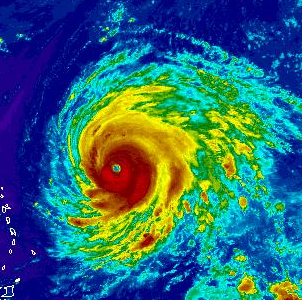
It has a shot at become a category 5, but if it were to weaken it would probably be from the northeast side of the storm. It's not annular yet, but it has a shot to do so. 11PM may tell. Thankfully this one appears to be out to sea.
| WeatherNut |
| (Weather Master) |
| Mon Sep 13 2010 02:13 AM |
|
|
Its a bit unnerving to see it still moving wsw though. There hasn't been much of a shift in the 8pm models though. My concern is a hurricane of this strength can 'pump up' the ridge making it stronger
| Random Chaos |
| (Weather Analyst) |
| Mon Sep 13 2010 03:34 AM |
|
|
|
|
Tropical Storm Julia as of 11pm update.
| Storm Hunter |
| (Veteran Storm Chaser) |
| Mon Sep 13 2010 05:16 AM |
| Attachment |
|
|
|
|
Really wish NASA would have made a forward Operating base this year for the Global Hawk on the EAST coast... saves thousands of miles/fuel. Read next year will be based in Va., money permitting! GH is passing Cancun, back to Drydren
|
danielw
|
| (Moderator) |
| Mon Sep 13 2010 11:55 AM |
|
|
|
|
I'm still seeing a 7 hour average of about 275 degrees, being generous, or due west From 03Z to 10Z. Using the link below, extreme slow speed and zoom on eye.
http://www.ssd.noaa.gov/goes/flt/t1/loop-vis.html
Long loop actually moved about 280 deg WNW for a while and then changed to 260 deg WSW giving a rough movement of due west.
| WeatherNut |
| (Weather Master) |
| Mon Sep 13 2010 03:43 PM |
|
|
I'm not seeing the quick recurve the GFS is showing. It looks like Igor has missed the first trough as it crosses 50w moving in a general W motion. These troughs exiting the US are not looking as robust as the ones that recurved Danielle, Earl and Fiona. They seem flat or zonal in comparison at the lower ends. If it does not recurve with the next trough, the JMA (Japanese) model will start to look more credible. It has been very consistent on the westerly direction through several runs
| WPBSUE |
| (Registered User) |
| Mon Sep 13 2010 05:21 PM |

|
|
|
The 11am discussion seemed to indicate there was less certainity with the projected path of Igor. Not sure that the Leewards or the southern US coast can breath a sign of relief just yet. I'll be watching closely as I hope others will be.
| Storm Hunter |
| (Veteran Storm Chaser) |
| Mon Sep 13 2010 05:32 PM |
|
|
|
|
Good morning Igor!
 Sleep well i see... lol
Use link for large loop with track superimposed~danielw
http://i44.photobucket.com/albums/f13/stormhunter7/boom2.gif

| JoshuaK |
| (Weather Guru) |
| Mon Sep 13 2010 07:46 PM |
|
|
Igor is maintaining a well defined eye but convection is weakening/decreasing associated with the system. Dry air that the system is moving into could be playing a part in that latter.
| Storm Hunter |
| (Veteran Storm Chaser) |
| Mon Sep 13 2010 08:25 PM |
|
|
|
|
RSO (Rapid Scan Operations) of Igor - 1 MIN updates! WOW... History with the NEW GOES-15 satellite, it was launched back in March this yr. 1 MIN UPDATES!!!! HI-RES.. beautiful storm!
http://rammb.cira.colostate.edu/ramsdis/...&height=600
| Random Chaos |
| (Weather Analyst) |
| Mon Sep 13 2010 10:37 PM |
|
|
|
|
An absolutely beautiful storm:

And a close up of the eye:

Larger versions: http://rapidfire.sci.gsfc.nasa.gov/gallery/?2010256-0913/Igor.A2010256.1640.1km.jpg
| Random Chaos |
| (Weather Analyst) |
| Tue Sep 14 2010 02:03 AM |
|
|
|
|
IR (ref) and WV (ref) is showing a marked weakening in the storm over the past couple hours, with ADT indicating a possible reduction in strength to around 120kts from the 130kts earlier. However, the last two IR frames are showing a significant increase in convenction surrounding the inner core. Additionally, the stadium eye is still extremely well defined and circular:

I suspect this has to do with interior dynamics changing in the storm. A secondary eyewall is forming, as seen in Microwave from several hours ago:

I suspect an ERC cycle will be well underway within the next 6 to 12 hours, with no additional strengthening until after then. However, after an ERC finishes, assuming conditions remain conducive to further strengthening, storms experience surface area growth as their structure becomes better suited for the size of the storm and the wind field expands as a direct result of the loss of the original eyewall. As the new eye contracts under favorable conditions, the winds will restrengthen, and often surpass the strength of the old storm.
Given that the storm is expected to be in favorable conditions for the next 48 hours, and the ERC is beginning at diurnal maxima, we could see no significant weakening of the storm and possible strengthening of the storm due to this ERC.
| WeatherNut |
| (Weather Master) |
| Tue Sep 14 2010 02:47 AM |
|
|
In looking at the 250-850mb steering it looks like the high is building back. I'm not sure how well I am interpreting this though

|
danielw
|
| (Moderator) |
| Tue Sep 14 2010 11:44 AM |
|
|
|
|
Apparently Igor is going to try to shoot the gap... or Col in this case. Last 7 hours of motion is near 300 degrees or WNW.
Shortwave/ trough dropping into the area north of Puerto Rico about 400 miles NW of Igor.
Will the trough pickup Igor or will he miss the bus?
| JoshuaK |
| (Weather Guru) |
| Tue Sep 14 2010 02:35 PM |
|
|
I was watching the last few frames of the Vis Loop. It looks like Igor did indeed make a turn to the NW, before moving to the WNW, but now it seems to be shifting back to a mostly W track, but this could be a mere wobble, have to wait for the next few frames to be certain.
| Old Sailor |
| (Storm Tracker) |
| Tue Sep 14 2010 03:55 PM |

|
|
|
With big storms like Igor they tend to stair step so l they go NW then West back to NW , you need to watch a trend for 6 hours or more..
| JoshuaK |
| (Weather Guru) |
| Tue Sep 14 2010 08:34 PM |
|
|
Saw the update on the main page about Karl. I'm not too suprised really, since that triangle area between Cancun, Honduras, and the Cayman Islands in the Western Caribbean tends to produce a lot of strong storms (Wilma being the top evidence of that). If it survives transition over the Yucatan, are we looking at another impact in the same general region as Alex and Hermine? I imagine Texas probably still isn't dried out yet after that latter.
EDIT: 5PM isn't out yet, but it looks like Igor has intensified since earlier in the day. Without looking at Dvorak data or Sat estimates, I'll predict an increase back up to 145 mph, at least, for 5PM. And to cover all the bases, looks like Julia is getting hit by strong shear from the WNW.
EDIT: Right on the money. =D
Everyone on Bermuda right now is probably hoping that the forecast track is waaaaayyyyy off for the latter period.
|
danielw
|
| (Moderator) |
| Tue Sep 14 2010 09:08 PM |
|
|
|
|
I saw the nice banding start earlier after Karl's cruise across the Caribbean. Probably wont make it to Hurricane force winds before landfall. But I may have to eat crow on that.
Not a good night to be in Belize or Quintana Roo,MX
and probably Yucatan and Campeche,MX tomorrow.
| Random Chaos |
| (Weather Analyst) |
| Wed Sep 15 2010 01:44 AM |
|
|
|
|
ADT values are increasing, with the upper end strength of the storm now showing potential for 140kt winds. However, this is unlikely given the eye structure. Microwave has shown the eye clearly open south for the past 6 hours or so, and the eye has taken on a ragged appearance. There is no sign of an ERC taking place, either.
Recent motion (past 4 hours or so) has again trended west. Cloud tops have also cooled significantly over the past several hours.
Edit: Where are all our hurricane watchers? This is the 2nd big, beautiful storm in the last couple weeks and almost no one is showing up to talk about it!
| Beaumont, TX |
| (Storm Tracker) |
| Wed Sep 15 2010 03:04 AM |
|
|
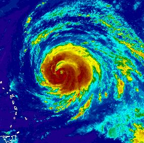
Igor is a gorgeous storm, that is for sure. Winds near 155 mph. Just an impressive storm.
| berrywr |
| (Weather Analyst) |
| Wed Sep 15 2010 04:25 AM |
|
|
|
|
These hurricanes are wonderful eye candy and unless you live in Bermuda none are a threat to the United States with the pattern we've been stuck in for the better part of summer...two distinct upper ridges, a persistent upper low over Eastern Canada, a TUTT stretching north to south to southwest to west and a COL....welcoming all passing hurricanes to a one way express ticket to the westerlies. The only game in town is recurvature if you're a Cape Verde system. I look at the long range models and over and over and over the same fate lies with all and if the shear doesn't take the trailing systems; the COL will snare them. The only systems were going to pay attention to are those that form in either the Caribbean or the Gulf of Mexico.
| Random Chaos |
| (Weather Analyst) |
| Wed Sep 15 2010 12:17 PM |
|
|
|
|
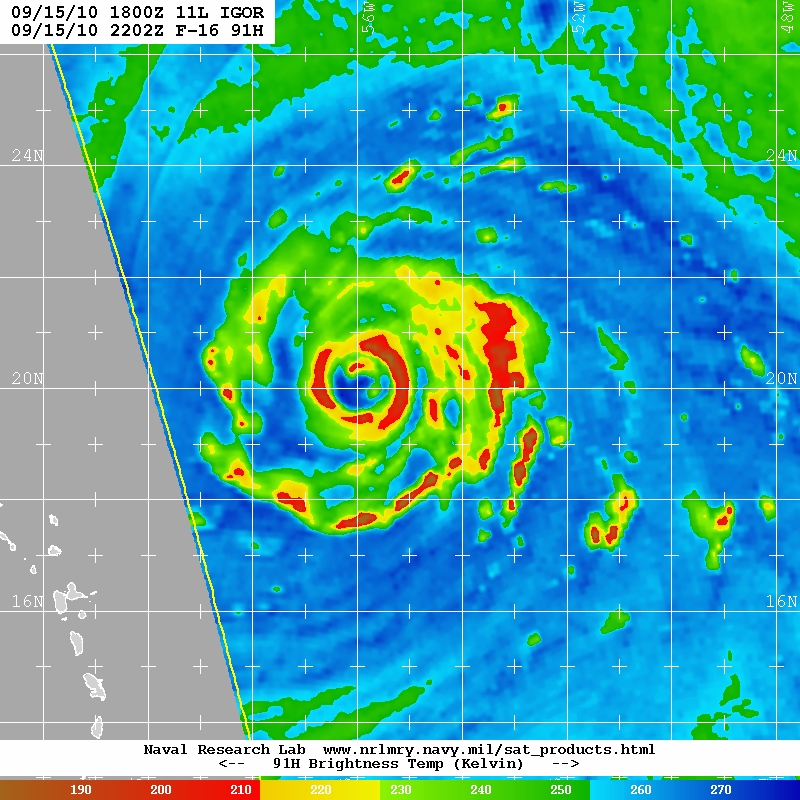
Over the past 6 hours, the eye has completely collapsed and is attempting to regenerate. Microwave shows what appears to be a gigantic 60nm eye trying to form around the old 15-20nm eye that is barely hanging on. This is the 9:40utc microwave pass.
However, what I noticed that really grabbed my attention was the change in IR structure over the past 9 hours. Compare the two following pictures:
0215utc
1115utc
Note the complete shedding of outer convection and the wrapping of the outer bands over each other. This is classic preparation for an annular storm. From Wikipedia:
"Observations show that an eyewall replacement cycle can lead to the development of an annular hurricane. ... Annular hurricanes have been simulated that have gone through the life cycle of an eyewall replacement. The simulations show that the major rainbands will grow such that the arms will overlap, and then it spiral into itself to form a concentric eyewall. The inner eyewall dissipates, leaving a hurricane with a singular large eye with no rainbands."
That appears to be exactly what is happening with Igor. Igor is not yet annular, but it looks to be in the development process. The biggest hampering aspect is the southern rain band is not fully formed, meaning that the new outer eye is not 100%, allowing the old inner core to continue to be driven moisture from the south. Whether Igor completes the ERC and becomes annular or is able to regenerate the old eye and stay non-annular is yet to be seen.
| Random Chaos |
| (Weather Analyst) |
| Wed Sep 15 2010 10:03 PM |
|
|
|
|
No posts all day?
Evening update: SSMIS Microwave overpass about an hour ago shows a clear outer eyewall fully surrounding the nearly completely collapsed inner eyewall. The new eye wall appears to be 80-90nm in diameter - this diameter is based on a 1.5 degree latitude width. ERC is still well underway. Organizationally, this storm is continuing to shed outer convection and wrap convective bands into a very large ring about the storm. There is very high axial symmetry to the storm that was not present this morning or yesterday. Will be interesting what the next 6 hours bring.
Reference: http://www.nrlmry.navy.mil/tcdat/tc10/AT...N-552W.47pc.jpg
Look at how much bigger Igor is vs this morning (previous post) - 2045utc:

| berrywr |
| (Weather Analyst) |
| Wed Sep 15 2010 10:26 PM |
|
|
|
|
What you're looking at is one, dry air entraining into the system and two, an eyewall replacement cycle; there are two eye walls here; the second about 60 nm out. It has contracted about 20 nm since this photo was taken. It is important to remember during eyewall replacement cycles the tops of these storms warm and while on IR there is a change in color does not mean it isn't there; I looked at a microwave loop today and the eye continues to exist though not on visible satellite; an obscure eye doesn't dismiss the fact it remains. NHC has a chart with some skill in this area of expertise; however it remains to this day a crap shoot.
| Random Chaos |
| (Weather Analyst) |
| Wed Sep 15 2010 11:09 PM |
|
|
|
|
Except that the microwave penetrates the clouds and shows the inner core collapsed. Take a look at the internal structure as seen in the last microwave overpass (about 2 hours ago now, more recent than the one I last linked to). The outer eyewall appears fully established and the inner eyewall is restricted to a very small region in the north:
This is an absolutely enormous storm. From north to south the is the equivalent distance from Washington DC to Miami - around 750 to 800 miles! Or an area that covers the entire Gulf of Mexico! Or by another measurement, about 20-30% larger than Hurricane Katrina was.
|
danielw
|
| (Moderator) |
| Wed Sep 15 2010 11:46 PM |
|
|
|
|
I see a 12Z ship report from the Bernardo Quintana A of 70 knot sustained wind just to the north of Cozumel,MX.
Further review indicates that it may have been an error or possibly rainband influenced.
A ship just over half the distance between Karl and the Bernardo reported 25 kt winds at the same observation.
15/18 C6KJ5 22.6 -87.0 28.0 100 14 1012.6 0.3 29.6 C6KJ5
15/12 C6KJ5 21.5 -86.6 020deg at 70knts 1010.4 1.8 30.5 * C6KJ5
13/18 C6KJ5 20.9 -86.7 31.0 060 7 1012.5 0.0 30.6 C6KJ5
13/06 C6KJ5 23.0 -87.8 29.0 040 16 1013.2 0.0 29.8 C6KJ5
http://www.sailwx.info/shiptrack/shipposition.phtml?call=C6KJ5
| Random Chaos |
| (Weather Analyst) |
| Thu Sep 16 2010 01:21 AM |
|
|
|
|
FYI, looks like SSD is having problems again. The config files that tell the flash animations which slides to load are incorrect on one of their servers. If you know how to edit your hosts file, adding this line will fix the issue:
140.90.213.166 www.ssd.noaa.gov
Note that your browser might not pick this up immediately, and on some systems you will also have to flush your DNS cache. SSD uses several servers, and it seems that at least the server at 129.15.110.160 is not sending the right info, resulting in images from earlier today being displayed.
I recommend you remove the hosts entry after a day or two, as it will probably cause long term issues to leave it in.