MikeC
|
| (Admin) |
| Tue Aug 23 2011 09:33 AM |
|
|
9PM EDT 23 August 2011 Update
Irene's eye is becoming visible on IR Satellite, and reports from two planes inside Irene now have found a pressure of 965 mb, and stronger winds, it appears Irene is on another strengthening spurt tonight.

6PM EDT 23 August 2011 Update
Hurricane Irene disrupted a bit from land interaction with Hispaniola and some shear is now crossing between the Turks and Caicos islands, bringing very strong winds to the islands. Hurricane Hunter Aircraft recently found a lower pressure of 969 so it may be on its way back, Irene is still forecast to be a major hurricane tomorrow.
The official forecast clips the outer banks of North Carolina, and primary operational models trends have been holding at this point for the last few runs. Because of this, there is a Mandatory evacuation of tourists from Ocracoke Island, NC. This starts tomorrow, and then expands to locals on Thursday. This will also include Cape Lookout and Hatteras.

Marine Tropical Storm watches are up east of Florida, but no land tropical storm watches as Irene should pass well east of Florida, some winds below tropical storm force may occur along the coastline along with beach erosion and heavy surf.
Beyond the Carolinas, persons up the Eastern Seaboard in particular Long Island north into New England really need to start monitoring this system.
Also, Puerto Rico is still getting flooding rains from the tail of Irene's rain bands.
11AM EDT 23 August 2011 Update
Hurricane Warnings are now up for all of the Bahamas. The forecast track shifted very very slightly to the east, but it is mostly an extension of the 5AM official forecast.
Florida is also now out of the cone of uncertainty. Although the odds for a southeast impact are lower, they are still fairly high for North Carolina, and new England will have to watch this system as well.
Original Update
Hurricane Irene has pulled in a bit of dry air from interaction with Hispaniola that disrupted the inflow a bit overnight, but appears to be on track toward the official forecast path. Outflow is starting to become well defined on the western side of the system, and it appears that it will likely regain and strengthen later today once it moves further away from the Island.
Computer model guidance from last night (with extra data collected from NOAA and Air force planes) has shifted right which implies Florida will see very little impact other than beach erosion and rough surf, which is good news for them (right along the coast may be a little breezy though), however based on the official forecast, a major hurricane is expected to pass 150 miles to the east of Florida, tearing through the central Bahamas. After which it is projected to make landfall in North Carolina near Wilmington late night Saturday into Sunday morning. Most models have come into agreement on it staying east of the US until North Carolina. The track may shift slightly west or east during the day, but should remain relatively in the cone. It is important to note, so far the trends have been to the east.
Beyond the forecast, After that it may rake along the east coast into New England, so folks as far up as Maine into Canada will want to watch Irene.
There are no new watches or warnings so far today.

Satellite shows a slightly disrupted hurricane (from land interaction with Hispaniola), but very little holding it back from regaining and strengthening later after it moves away. Outflow to the north and west of the storm is very conductive for development. There is a slight elongation north to south in the system which would imply a slight tug northward, which is in line with the forecast projections. If anything changes in the near term it would be because of any interesting interactions with Hispaniola. Generally though, Irene is a very large hurricane and field fields are very large so most of the Bahamas will be affected in some way.
Those in Florida will still want to watch it to see exactly how close it gets, but it would have to get within 60 miles of the coast to see any significant hurricane weather from Irene (it is forecast to be 150 miles east near it's closest approach point). And chances of that are low, around 5%, usually not enough to change plans. Chances for Tropical Storm force winds are a little higher right along the Florida east coast at 30% In short, on it's closest approach, you probably won't want to be on the beach. Surfers will get very long period swells as it approaches, but at closest approach it will be too rough to do much.
For those keeping track, the official forecast gets updated at 5AM, 11AM, 5PM and 11PM, with intermediate advisories at 2AM, 8AM, 2PM, and 8PM while watches/warnings are active. In majors, usually updates can come even more often than that. As a note, there is nothing suggesting a shift back to the west will occur right now, if a change would occur, odds are it would be the opposite (to the east).
Those in North Carolina need to use the next few days for preparations, and South Carolina will want to any westward shifts. Those further north into New England will want to watch the progress of Irene as well.
The Bahamas will get a very rough next few days with a major hurricane forecast to be across the heart of the islands.
See the Forecast Lounge for more speculation on Irene.
Event Links
Flhurricane Disaster and preparatory information thread.
{{BahamasMedia}}
We are now recording the Rocky Bay webcam at Abaco Island in the Bahamas -- note these images are large.
Hope Town Fire rescue on Abaco Island, storm information
Updated Map of Mark Sudduth from HurricaneTrack.com, with video and radar for Irene approach See HurricaneTrack.com for more information.
{{StormCarib}}
{{EastFloridaRadar}}
{{MidAtlanticRadar}}
{{StormLinks|Irene|09|9|2011|2|Irene}}
{{StormLinks|98L|98|10|2011|0|98L}}
{{StormLinks|90L|90|11|2011|0|90L}}
Long term Central Atlantic wide area Water Vapor Satellite for Hurricane Season Peak flhurricane)
Long term West Atlantic wide area Water Vapor Satellite for Hurricane Season Peak flhurricane)
|
MikeC
|
| (Admin) |
| Tue Aug 23 2011 10:34 AM |
|
|
Recon aircraft is just now taking off from Saint Croix for another peek into Irene
| Random Chaos |
| (Weather Analyst) |
| Tue Aug 23 2011 10:42 AM |

|
|
|
Irene keeps firing up deep convection over the core. Every time it starts to die down, new deep convection appears on IR, showing that the storm is still quite healthy even with the dry air entrainment from the affects of the mountains of Hispanola. This entrainment is very clear and will take some time to work out; probably will not fully work out until the storm is further from the mountains. We may see a lapse in storm growth until then, giving us at least several more hours of respite from additional strengthening.
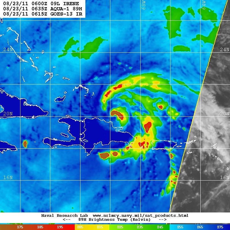
I also included a microwave pass from Modis (via NRL) which shows the outer convective band skirting around the south side of Hispanola in order to avoid the land and mountains. The eye is clearly disrupted, as seen in that pass. While several hours old, the storm has not changed much in IR appearance since then.
What one can see in the attached Water Vapor image is how the mountains are causing dry air ingestion into the storm. South of the mountains is a line of moderate to deep convection spiraling around to the right and north of the storm just outside the dry air stream caused by the land interaction. The storm is able to generate plenty of convection, but the land is keeping the system weaker than it would otherwise be.
The 00Z model runs are out, and converge more closely on a hit somewhere in the Carolinas. However, I want to bring special attention to the 00Z GFS run because it highlights why no one should stop paying attention to the storm. There is no guarentee that the 00Z GFS run is accurate, but it's a warning of what could be. That run shows the track strafing Florida, Georgia, and South Carolina into a North Carolina landfall, across the southern Chesapeake Bay, back out to sea, strafing the New Jersey coast, then back inland over Long Island and Massachusetts, possibly reemerging off the coast only to again make landfall in Maine. The potential exists that the entire Atlantic Seaboard will have significant effect.
This is only what one model run shows, but no one should ignore this storm.
00Z GFS: http://moe.met.fsu.edu/cgi-bin/gfstc2.cg...;hour=Animation
Dry air interaction (Water Vapor):
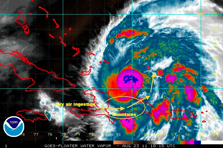
Mountain effects (Microwave via NRL):
| OrlandoDan |
| (Weather Master) |
| Tue Aug 23 2011 10:45 AM |

|
|
|
I am concerned that the interaction with the high mountains of the DR are keeping Irene a bit weaker than the models anticipated. This may result in a more westerly component of movement with this weaker storm.
| GuppieGrouper |
| (Weather Master) |
| Tue Aug 23 2011 11:05 AM |
|
|
The models have had trouble all along with the storm until this new data came in. I think what comes from the new data should be more of what you need to know.I know its scary having a large storm bearing down and that is why we have to stay alert until it is past our latitude.
| Wanna-Be-Storm-Chaser |
| (Weather Hobbyist) |
| Tue Aug 23 2011 11:35 AM |
|
|
Help me to uderstand please. If she weakens from the mountains and you stated a more westerly, does that mean it will take longer for her to turn to the NW?
|
MikeC
|
| (Admin) |
| Tue Aug 23 2011 12:30 PM |
|
|
Quote:
Help me to uderstand please. If she weakens from the mountains and you stated a more westerly, does that mean it will take longer for her to turn to the NW?
The storm actually went a bit right (north) of the 5AM track, this increases the chance it will stay further east.
I really don't see any reason it would get closer to Florida than about 150 miles east.
Irene is pulling away from Hispaniola now.
|
MikeC
|
| (Admin) |
| Tue Aug 23 2011 01:03 PM |
|
|
As a note, the current thinking is similar (but not exactly the same) to Hurricane Floyd (1999) (this link superimposes Floyd's track with Irene) where it stayed east of Florida at a similar distance, although Irene may be a bit further east than Floyd.
| ralphfl |
| (Weather Master) |
| Tue Aug 23 2011 01:06 PM |
|
|
The models have shifted even more to the east.The data was put in the models of this 100mph storm it would have to drop down to a TS to even consider going west.
Watch it but look at the data it is clear to see what this storm is going to do.
|
MikeC
|
| (Admin) |
| Tue Aug 23 2011 01:19 PM |
|
|
The US water vapor shows the trough moving southward near GA/SC line that is expected to eventually jog Irene more northward. (Although it's spawning an interesting convection area east of Jax) This appears to be stronger than the models were forecasting, which increases the chance the storm will move more north and east sooner, and may only clip the Outer Banks. Still a bit too early to be sure though.
This along with the other long water vapor image may be helpful if you are trying to gauge Irene's motions by satellite.
| JMII |
| (Weather Master) |
| Tue Aug 23 2011 02:20 PM |

|
|
|
Looking at Irene this AM you can see a slightly elongated shape (N to S) as the western side (and the SW) can't get its act together. The mountains are clearly limiting her potential, thus why the NHC is forecasting a Cat 3 once she is in open water. The models have finally gotten into alignment and agree Irene will stay off the coast of FL. The front pushing off the east coast of the US is pretty strong, I wonder if long term Irene will shift even further east and make landfall on the outer banks of NC or miss them entirely? Once she gains strength she'll be pulled north. Strange to see a storm this strong not have a defined eye yet, but once again the disruption to the SW is keeping the core from really wrapping up.
As for S FL I would expect minimal Tropical Storm force winds on Thursday, the hurricane force winds are still isolated very close to the system's core.
| WeatherNut |
| (Weather Master) |
| Tue Aug 23 2011 02:44 PM |
|
|
Looks like the latest recon has arrived at the center and the lowest pressure so far is 976.4 so not much of a drop since the last advisory
| scottsvb |
| (Weather Master) |
| Tue Aug 23 2011 02:53 PM |
|
|
S Florida will not get anything close to TS force winds unless somehow the system moves at least 100 miles further west. There might be some gusts near that in a squall or 2 that comes inland along the east coast of florida..but the core of the winds will remain offshore.
| ralphfl |
| (Weather Master) |
| Tue Aug 23 2011 02:53 PM |
|
|
The whole state of Florida is now out of the code but for a very small part above MIA but in reality the whole state is clear of the cone as of now.
| Firebug814 |
| (Registered User) |
| Tue Aug 23 2011 03:24 PM |
|
|
Just curious, the coordinates that were just given are more of a wsw aren't they? Am I reading that wrong?
| JMII |
| (Weather Master) |
| Tue Aug 23 2011 03:35 PM |
|
|
|
|
Quote:
S Florida will not get anything close to TS force winds unless somehow the system moves at least 100 miles further west. There might be some gusts near that in a squall or 2 that comes inland along the east coast of florida..but the core of the winds will remain offshore.
With the adjustment of the cone further east yet again I agree. However I am just wondering how big she'll expand to once in open water. If the weather (rain/wind) on the NE side ever wraps around to the SW this will be a large system. The NHC tends to over estimate the size (and strength) of the wind field so your most likely correct: the east coast of FL will not see sustained TS winds.
The winds in Pine Cay (T&C Islands) are gusting to 40mph from the N right now and the pressure is dropping. Should be interesting to keep tabs on this location today and into tonight. The center of Irene is still 100 miles away but should pass within 40 miles of this location around 8PM tonight.
| javlin |
| (Weather Master) |
| Tue Aug 23 2011 03:43 PM |
|
|
You read it right just a blip in the scheme of things,wobble.Now if it was to happen all day then concern but the models have a good handle on this one.
| scottsvb |
| (Weather Master) |
| Tue Aug 23 2011 03:52 PM |
|
|
Irene should move more west today..but it wont mean much cause she was
suppose to be moving west the past few days. Reason she will move west
is cause of the trough digging down off the SE U.S. and backing into florida
carving a thin ridge to extend SW. It usually happens with strong hurricanes
just before a turn into a trough.
Think of holding your hand and making a fist.... (that is your ridge)
Then take your index finger and point it at a 225dg angle .... that is a
narrow ridge that gets more heat infront of the trough as it digs. It's
kinda my own explanation of west jogs infront of the pull northward.
Anyways you should continue to see a more west movement today
maybe around 280dg then the turn tonight-Weds more NW up the bahama
chain.
| Ed in Va |
| (Weather Master) |
| Tue Aug 23 2011 04:07 PM |
|
|
What is your assessment of the current forecast...accurate?
| scottsvb |
| (Weather Master) |
| Tue Aug 23 2011 04:14 PM |
|
|
Ed... I think if you live on the coast of Virginia,NC,SC you should probably be ready to move inland
sometime on Weds afternoon... NHC will know where or if it will make landfall after Weds 12Z model runs come out.
|
danielw
|
| (Moderator) |
| Tue Aug 23 2011 04:38 PM |

|
|
|
Irene's Eye is clearly visible in this photo taken 22 minutes ago. It almost appears to be an annular Eye.

| Tazmanian93 |
| (Weather Master) |
| Tue Aug 23 2011 04:49 PM |

|
|
|
Is there any particular reason for that?
Quote:
Irene's Eye is clearly visible in this photo taken 22 minutes ago. It almost appears to be an annular Eye.
|
danielw
|
| (Moderator) |
| Tue Aug 23 2011 05:05 PM |
|
|
|
|
A hurricane with an Annular Eye is normally a well developed, steady state hurricane. I don't classify Irene as well developed.
But the smooth round circular Eye is nearly annular.
Similar to looking into a piece of pipe, or the hole in a doughnut.
From Wikipedia:
An annular hurricane, also known as a truck tire or doughnut hurricane,[1] is a tropical cyclone in the Atlantic or Eastern Pacific Oceans that features a large, symmetric eye surrounded by a thick ring of intense convection. This type of storm is not prone to the fluctuations in intensity associated with eyewall replacement cycles, unlike typical intense tropical cyclones. Annular hurricanes also tend to persist, even when encountering environmental conditions which easily dissipate most other hurricanes. Forecasters have difficulty predicting the behavior of annular hurricanes; they are a recently recognized phenomenon, and as such, little is known about their tendencies. Because of this, they can be more dangerous than typical hurricanes.
http://en.wikipedia.org/wiki/Annular_hurricane
| Ed in Va |
| (Weather Master) |
| Tue Aug 23 2011 05:11 PM |
|
|
Isabel, another "I" storm with a similar forecasted landfall, was also annular.
| WeatherNut |
| (Weather Master) |
| Tue Aug 23 2011 05:28 PM |
|
|
Pressure is down to 974 on latest pass through the center. Annular Hurricanes are extremely rare, btw Some other examples where Luis (95), and also Wilma as it was crossing FL.
|
danielw
|
| (Moderator) |
| Tue Aug 23 2011 05:32 PM |
|
|
|
|
Quote:
Pressure is down to 974 on latest pass through the center. Annular Hurricanes are extremely rare, btw
That's what threw me off when i first saw the Eye. I've enhanced it locally and I still can't determine if it's annular or not.
The ocean can be seen in my enhancement. But the angle is a bit off.
I seriously doubt Irene is annular at this point due to her fluctuations.
|
MikeC
|
| (Admin) |
| Tue Aug 23 2011 06:00 PM |
|
|
There was just a 5.8 mag earthquake northwest of Richmond Virginia.
Right now the track of Irene is on the NHC's track. I don't think it's going to change much if at all over the next few days.
BTW, Irene is nowhere near annular, the entire system needs to be nearly perfectly round for that.
| vineyardsaker |
| (Weather Guru) |
| Tue Aug 23 2011 06:00 PM |
|
|
|
|
aren't *ALL* hurricanes eyes annular in shape?
does somebody have 2 photos showing the differences between annular and non-annular hurricane eyes?
thanks!
|
danielw
|
| (Moderator) |
| Tue Aug 23 2011 06:07 PM |
|
|
|
|
Looks like I stirred up something. This link should help... somewhat.
http://rammb.cira.colostate.edu/resources/docs/annular_knaff.pdf
| CarolinaGurl |
| (Weather Watcher) |
| Tue Aug 23 2011 06:16 PM |

|
|
|
We felt the shake here in Wilmington, NC - not enough to worry about with Irene to add earthquakes on top of it.
| VolusiaMike |
| (Weather Hobbyist) |
| Tue Aug 23 2011 06:23 PM |
|
|
|
|
Getting reports from internet connections of people feeling it in WV, SC, NC, NY, the entire area... that's just what they would need, try to deal with the aftermath of a quake with a Hurricane on the way!!!
| tpratch |
| (Moderator) |
| Tue Aug 23 2011 06:43 PM |

|
|
|
Quote:
There was just a 5.8 mag earthquake northwest of Richmond Virginia.
Right now the track of Irene is on the NHC's track. I don't think it's going to change much if at all over the next few days.
BTW, Irene is nowhere near annular, the entire system needs to be nearly perfectly round for that.
Yeah - we had to evacuate my building - just got back in a little bit ago.
I've been through Cat 4 storms, but being on the 3rd floor when an earthquake hits? You start wondering if you shouldn't head down the stairs

/sorry for the OT post.
//keeping tabs on the storm for my MiL
| B_from_NC |
| (Verified CFHC User) |
| Tue Aug 23 2011 06:53 PM |
|
|
Hmmmm.... Tornadoes here in Raleigh in April... An earthquake (house was shaking pretty good, was just 125 miles north of here). and possibly Irene..... Whats next????
Brian
| Tazmanian93 |
| (Weather Master) |
| Tue Aug 23 2011 06:58 PM |
|
|
|
|
Colorado had one today also
Quote:Quote:
There was just a 5.8 mag earthquake northwest of Richmond Virginia.
Right now the track of Irene is on the NHC's track. I don't think it's going to change much if at all over the next few days.
BTW, Irene is nowhere near annular, the entire system needs to be nearly perfectly round for that.
Yeah - we had to evacuate my building - just got back in a little bit ago.
I've been through Cat 4 storms, but being on the 3rd floor when an earthquake hits? You start wondering if you shouldn't head down the stairs
/sorry for the OT post.
//keeping tabs on the storm for my MiL
|
MikeC
|
| (Admin) |
| Tue Aug 23 2011 07:01 PM |
|
|
Latest Recon vortex has a closed eye again, with pressure down to 976, it's getting far enough away from Hispaniola it may be attempting another strengthening spurt. Winds are down though because of land interaction so it may actually go back to Cat 1 for a bit.
| Random Chaos |
| (Weather Analyst) |
| Tue Aug 23 2011 08:53 PM |
|
|
|
|
Daniel, I took a look at the high res Modis pass from a couple hours ago and the storm didn't look annular to me. Newer GEO passes are looking even worse.
OT: Felt the earthquake quite well. Slow shaking, then more violent shaking. Nothing fell, though.
| JMII |
| (Weather Master) |
| Tue Aug 23 2011 09:39 PM |
|
|
|
|
The track has shifted east yet again... at this rate its going to miss NC and make landfall in NJ. Down a few mph making it a Cat 1 temporarily.
Grace Bay (T&C Islands) is reporting winds out of the NE at 35 gusting to 60 mph, pressure down 0.3 inches from early this AM. The center of Irene is still approximately 80 miles away, but by 2AM this location will in the thick of things with storm being only 30-40 miles away (just to SW) if the track holds.
| ralphfl |
| (Weather Master) |
| Tue Aug 23 2011 09:46 PM |
|
|
most models are east of the track even more and most of them now show no US hit.
| syfr |
| (Verified CFHC User) |
| Tue Aug 23 2011 09:54 PM |

|
|
|
Grace Bay cam here, shows the effects already:
http://www.theregentgrandresort.com/regentwebcam.html
|
MikeC
|
| (Admin) |
| Tue Aug 23 2011 10:26 PM |
|
|
we're now recording the Rocky Bay webcam at Abaco Island in the Bahamas -- note these images are large.
| typhoon_tip |
| (Meteorologist) |
| Tue Aug 23 2011 10:48 PM |
|
|
Persons up the Eastern Seaboard including, if perhaps particularly New England really need to start monitoring this system.
This is a bit of an anomalous set up in that some of the better deep layer mechanics for intensification actually exist (per modeling) as the system is lifting N along the Gulf Stream. The collocation of those circumstances make intensity along a guidance-converged track consensus uncertain. A lot of these guidance that show intensification in that region of it prognosticated track have a basis in synoptic reasoning.
| syfr |
| (Verified CFHC User) |
| Tue Aug 23 2011 11:28 PM |
|
|
|
|
Quote:
The collocation of those circumstances make intensity along a guidance-converged track consensus uncertain. A lot of these guidance that show intensification in that region of it prognosticated track have a basis in synoptic reasoning.
I think this means in English that "we don't know exactly how strong the storm is going to get as it moves along the forecast track , but it sure might get stronger!"
|
MikeC
|
| (Admin) |
| Wed Aug 24 2011 12:33 AM |
|
|
Recon is finding pressures of 965 mb, Irene is strengthening over the Turks and Caicos, not good news for them.
| Random Chaos |
| (Weather Analyst) |
| Wed Aug 24 2011 12:37 AM |
|
|
|
|
Eye is also becoming visible on IR and WV loops, though it is not entirely clear of convection:
http://www.ssd.noaa.gov/goes/flt/t2/flash-avn.html
http://www.ssd.noaa.gov/goes/flt/t2/flash-wv.html
| Joeyfl |
| (Weather Guru) |
| Wed Aug 24 2011 12:48 AM |

|
|
|
Check out this satellite clearly see eye and very deep convection/eyewall just south of Turks island...All kinds of cool features can be overlayed onto satellite including guidance.
http://www.wunderground.com/wundermap/?l...;mm=0&hur=0
*Note the due west wobble past hour*
| Random Chaos |
| (Weather Analyst) |
| Wed Aug 24 2011 12:54 AM |
|
|
|
|
Eye fix only 9 minutes apart by two difference planes has a 11nm difference in eye. Looks like an ERC is underway:
Vortex recon at 0:06Z
H. Minimum Sea Level Pressure: 968mb (28.59 inHg) - Extrapolated
L. Eye Character: Open in the southwest
M. Eye Shape & Diameter: Circular with a diameter of 20 nautical miles (23 statute miles)
Vortex recon at 0:15Z
H. Minimum Sea Level Pressure: 970mb (28.64 inHg)
L. Eye Character (Undecoded): RAGGED
M. Eye Shape & Diameter: Circular with a diameter of 31 nautical miles (36 statute miles)
|
MikeC
|
| (Admin) |
| Wed Aug 24 2011 01:00 AM |
|
|
With the latest recon wind report it looks like Irene is back up to Category 2 at least.
|
MikeC
|
| (Admin) |
| Wed Aug 24 2011 01:28 AM |
|
|
Added some Bahamas related links:
{{BahamasMedia}}
We are now recording the Rocky Bay webcam at Abaco Island in the Bahamas -- note these images are large.
Hope Town Fire rescue on Abaco Island, storm information
| cieldumort |
| (Moderator) |
| Wed Aug 24 2011 01:32 AM |

|
|
|
Quote:
Eye fix only 9 minutes apart by two difference planes has a 11nm difference in eye. Looks like an ERC is underway:
Vortex recon at 0:06Z
H. Minimum Sea Level Pressure: 968mb (28.59 inHg) - Extrapolated
L. Eye Character: Open in the southwest
M. Eye Shape & Diameter: Circular with a diameter of 20 nautical miles (23 statute miles)
Vortex recon at 0:15Z
H. Minimum Sea Level Pressure: 970mb (28.64 inHg)
L. Eye Character (Undecoded): RAGGED
M. Eye Shape & Diameter: Circular with a diameter of 31 nautical miles (36 statute miles)
That seems a little rapid, and perhaps it is, but such a fluctuation is not necessarily indicative of an eyewall replacement cycle, or even an imminent ERC. There is little suggestion that concentric eyewalls exist at this time (a requisite of a potential replacement cycle).
| Random Chaos |
| (Weather Analyst) |
| Wed Aug 24 2011 01:36 AM |
|
|
|
|
That is what I was thinking, but the TRMM overpass microwave imagery shows the dual eyewall structure. The remnants of the old wall are visible in the eastern semicircle, but the outer eyewall is visible through the entire diameter.
From NRL:

| cieldumort |
| (Moderator) |
| Wed Aug 24 2011 01:55 AM |
|
|
|
|
In the above image provided it is Important to note the time stamp on the microwave pass (2312Z), so if this was proof of an extra eyewall, it would have been from an eyewall that has already cycled, not of one currently undergoing a replacement, nor about to do so. Recon has made no mention I can find of concentric eyewalls, I have not seen that NHC has as much as speculated, and it is very uncommon for Cat1/2s to undergo an ERC. More likely what we are looking at is just a well-curved inflow band, rather than remnants of a former eyewall.
|
danielw
|
| (Moderator) |
| Wed Aug 24 2011 02:21 AM |
|
|
|
|
Product: NOAA Vortex Message (URNT12 KWBC)
Transmitted: 23rd day of the month at 23:17Z
Aircraft: Lockheed WP-3D Orion (Reg. Num. N42RF)
Storm Number: 09
Storm Name: Irene (flight in the North Atlantic basin)
Mission Number: 10
Storm Number & Year: 09L in 2011
Observation Number: 36
A. Time of Center Fix: 23rd day of the month at 22:42Z
B. Center Fix Coordinates: 21°2'N 71°45'W (21.0333N 71.75W)
B. Center Fix Location: 49 miles (79 km) to the SW (233°) from Cockburn Town, Turks and Caicos Islands (GBR).
C. Minimum Height at Standard Level: Not Available
D. Estimated (by SFMR or visually) Maximum Surface Wind: 67kts (~ 77.1mph)
E. Location of the Estimated Maximum Surface Wind: 15 nautical miles (17 statute miles) to the WNW (284°) of center fix
F. Maximum Flight Level Wind Inbound: From 26° at 81kts (From the NNE at ~ 93.2mph)
G. Location of Maximum Flight Level Wind Inbound: 27 nautical miles (31 statute miles) to the WNW (291°) of center fix
H. Minimum Sea Level Pressure: 969mb (28.61 inHg)
I. Maximum Flight Level Temp & Pressure Altitude Outside Eye: 15°C (59°F) at a pressure alt. of 2,438m (7,999ft)
J. Maximum Flight Level Temp & Pressure Altitude Inside Eye: 20°C (68°F) at a pressure alt. of 2,418m (7,933ft)
K. Dewpoint Temp (collected at same location as temp inside eye): 14°C (57°F)
K. Sea Surface Temp (collected at same location as temp inside eye): Not Available
L. Eye Character: Open in the south
M. Eye Shape & Diameter: Circular with a diameter of 35 nautical miles (40 statute miles)
N. Fix Determined By: Penetration, Radar, Wind, Pressure and Temperature
N. Fix Level: Other - Not surface, 1500ft, 925mb (if vortex is newer than about mid 90's; see note for more), 850mb, 700mb, 500mb, 400mb, 300mb or 200mb
O. Navigation Fix Accuracy: 1 nautical mile
O. Meteorological Accuracy: 1 nautical mile
Remarks Section - Remarks That Were Decoded...
Maximum Flight Level Wind: 81kts (~ 93.2mph) in the northwest quadrant at 22:35Z
Remarks Section - Additional Remarks...
CENTER DROP SPLASHED AT 20 KT
Outside/ Inside Temp Spread is 5C
Inside Temp/ Dewpoint Spread is 6C
With an Open Eye Wall. The spreads should begin to increase shortly.
Convection is consolidating and Dmax is about 6 hours from now.
Dmax is the Diurnal Maximum near Sunrise. Whereas Dmin is the Diurnal Minimum near Sunset.
| typhoon_tip |
| (Meteorologist) |
| Wed Aug 24 2011 02:35 AM |
|
|
It does give that appearance but this may actually be incidental. EWR cycles tend to take place with very intense cyclones, usually above lower level Category 3 storms.
| typhoon_tip |
| (Meteorologist) |
| Wed Aug 24 2011 02:38 AM |
|
|
Quote:
Quote:
Eye fix only 9 minutes apart by two difference planes has a 11nm difference in eye. Looks like an ERC is underway:
Vortex recon at 0:06Z
H. Minimum Sea Level Pressure: 968mb (28.59 inHg) - Extrapolated
L. Eye Character: Open in the southwest
M. Eye Shape & Diameter: Circular with a diameter of 20 nautical miles (23 statute miles)
Vortex recon at 0:15Z
H. Minimum Sea Level Pressure: 970mb (28.64 inHg)
L. Eye Character (Undecoded): RAGGED
M. Eye Shape & Diameter: Circular with a diameter of 31 nautical miles (36 statute miles)
That seems a little rapid, and perhaps it is, but such a fluctuation is not necessarily indicative of an eyewall replacement cycle, or even an imminent ERC. There is little suggestion that concentric eyewalls exist at this time (a requisite of a potential replacement cycle).
Agreed with you here - I just also mentioned to 'Chaos that this was probably incidental imagery more than action taking place, and explained why.
| OrlandoDan |
| (Weather Master) |
| Wed Aug 24 2011 04:20 AM |
|
|
|
|
Water Vapor appears to show a very westerly component of movement between 23:45 UTC and 3:45 UTC.
|
Ed Dunham
|
| (Former Meteorologist & CFHC Forum Moderator (Ed Passed Away on May 14, 2017)) |
| Wed Aug 24 2011 04:47 AM |
|
|
Excellent observation. Note that at 03Z NHC nudged the latitude to 21.3N but recon at 0337Z reported 21.1, so thats about 12 miles of northward component that never occurred. However the general motion over an extended period of time may have been WNW. Like many a past stubborn storm (think Bertha), the timing of the expected turn can certainly get to be exasperating.

ED
|
Ed Dunham
|
| (Former Meteorologist & CFHC Forum Moderator (Ed Passed Away on May 14, 2017)) |
| Wed Aug 24 2011 05:20 AM |
|
|
Water vapor loop shows a wave developing on the front off the coast of North Carolina which is pulling down a reinforcing ridge over South Carolina and Georgia. This could maintain a tighter compression ridge over Irene and contribute to the westerly motion. I can't see anything else that would cause it other than a rather unusual wobble because of some unknown hurricane dynamic. It seems unusual when you are anticipating an imminent turn to the northwest.
ED