MikeC
|
| (Admin) |
| Thu Sep 01 2011 11:45 PM |
|
|
Update - Monday, September 5th, 2011, 11:35AM EDT
At 05/09Z, the NWS Hydrometeorological Prediction Center relocated Ex-TD Lee at 30.2N 90.8W - still in Louisiana, and at 05/12Z, NHC used 30.4N 90.2W for an additional model run on Lee. At 05/15Z, the remnants of Lee were located at 30.5N 89.9W with movement over the past 12 hours generally to the east. The extratropical system is about to enter southern Mississippi and move into Alabama tonight.
Hurricane Katia has completed an eyewall replacement cycle - a bit unusual but not unheard of for a Cat II Hurricane - and movement over the past 6 hours has been more to the WNW rather than NW although the 12-hour average is still NW. NHC expects a general NW motion to continue with an eventual turn to the north and northeast. The track has again adjusted slightly to the east, and although Bermuda, North Carolina, Massachusetts, Nova Scotia and Newfoundland are not in the cone, the overall area of tropical storm force winds has been expanded so some gusty winds will be likely in Bermuda and possible elsewhere along the coast as Katia passes by well offshore during the week.
The tropical wave in the far eastern Atlantic has been designated as Invest 95L. At 05/12Z, 95L was located well southwest of the Cape Verde Islands at 9.1N 29.7W with winds of 25 knots and pressure at 1009MB. Movement overnight was to the west at 14 knots. The tropical wave is developing good structure and active convection with additional development likely as the system moves to the west and west northwest over the next few days.
ED
Update - Monday, September 5th, 2011, 12:15AM EDT
Category II Hurricane Katia is located well to the north of the northern Leeward Islands still moving to the northwest at 13mph. Some additional intensification is possible for the next couple of days as Katia continues to move to the northwest, eventually turning to the north and then northeast. Models have adjusted eastward and so has the NHC forecast track. An upper level low near 32N 52W could begin to have more of an influence on the future track of Katia. Bermuda is currently not in the cone, but additional eastward adjustments to the track are possibly so folks in Bermuda still need to closely monitor any changes in Katia's track.
By midweek, Katia will begin to move over cooler SSTs and this should slowly reduce the sustained winds later in the week. With fairly good model consensus, its looking more and more like Hurricane Katia will remain at sea - but continue to monitor Katia for any unexpected changes. High surf and rip currents are anticipated along most of the eastern seaboard, in the Bahamas, and on Bermuda in the week ahead. Check with your local forecast office for details on expected hazardous beach conditions in your area.
NHC has issued its final advisory on Tropical Depression Lee. Winds and convection are both decreasing as Lee transitions to an extratropical cyclone. All Tropical Storm Warnings have been discontinued. Post TD Lee is now moving northeastward in south central Mississippi and will be moving toward northern Alabama over the next couple of days where the system is expected to merge with a shortwave trough. Flooding rains are still expected to move from the central Gulf coast into the Appalachian Mountains.
An active tropical wave near 9N 28W at 05/04Z is the only other noteworthy feature in the basin at this time.
ED
8:30 AM 4 September 2011 Update
Tropical Storm Lee still is still over the coast of south central Louisiana, near Vermillion Bay. Lee is still quite disorganized, with much of the convection gone on the southwest, and northwestern quadrants.
Some strong rain bands are moving through the Florida Panhandle and Alabama today, and will move up through parts of Mississippi, Louisiana, Arkansas, Alabama, Western Georgia and Tennessee over the next few days as lee weakens over land. The tropical storm warning goes from Destin, FL westward to Intracoastal city, LA.
Katia's official forecast has shifted a bit west from yesterday, however most guidance and water vapor analysis still suggests that it most likely will recurve before the United States. The trends will need to be monitored (especially the trends of the UKMet model vs the trends of virtually everything else). But right now there are more factors favoring a recurve.
7:28 AM 3 September 2011 Update
Bands of heavy rain along with tornadoes continue in the Central and Northeastern Gulf coasts, all associated with Tropical Storm Lee. It's still moving northward but still remains rather disorganized, another few days of rain is expected in the area.
Katia's holding as a category 1 hurricane, as it moves northwest, odds have slightly increased that it will recurve before the US.
1:30 PM 2 September 2011 Update
THIRTEEN has been upgraded to Tropical Storm Lee. While Lee is expected to intensify, within still weak steering currents, flooding will likely continue to be the greatest threat.
6:30 AM 2 September 2011 Update
Tropical Depression 13 remains a highly sheared, but active tropical depression.
Right now, the western side of the storm remains fairly dry, while the eastern side is extremely wet. With the shear, if the storm forms it will likely be a larger system without a strong inner core, which would make it highly unlikely to strengthen too much.
It will, however, be enough to bring large amounts of rainfall to the Northern Gulf, and some rainfall to the eastern Gulf. It is possible for the storm to be closer to a hybrid storm than a classic tight core tropical cyclone. Upwelling will also likely prevent too much intensification. The forecast calls for it to be upgraded to a Tropical Storm later today.
Texas it looks like, unfortunately, won't see much from this system.

There is virtually no movement with the storm right now, as the center is relocating more than moving, and the steering currents remain weak, which means days of the system offshore, bringing band after band of rain to Louisiana and surrounds, with heavy rain and the possibility of short lived tornadoes.
Any east facing coastal areas in the Northern Gulf will be prone to some coastal flooding with prolonged easterly winds. Winds will be slow at first, but gradually increasing through the days until the system exits. Rainfall will be very dependent on where the bands go, 5-10" is possible, some places more.
Track wise, pick a place, there is very little skill at forecasting a track of a virtually stationary tropical storm, generally anywhere in the tropical storm Warning area.
Katia remains a tropical storm this morning, and odds still marginally favor it turning out to sea before the United States. The area south of Nova Scotia may have a chance to develop before it gets into areas too cold.
Original Update
Tropical Depression 13 forms in the Gulf of Mexico about 225 miles southwest of the mouth of the Mississippi river.
Tropical Storm warnings are now up for the northern Gulf of Mexico coastline from Pascagoula, Mississippi westward to Sabine Pass, TX.

Tropical Depression 13 is forecast to become Tropical Storm Lee tomorrow. It is expected to move extremely slowly as it approaches the northern Gulf coastline, dumping very heavy rainfall.
TD#!3 is a borderline tropical depression, and is still quite disorganized at the moment and the center may "Reform" a few times before it gets its act together. Those in the Tropical Storm warning area will likely see an extended period of windy conditions with wave after wave of heavy rainfall.
Katia was downgraded to a Tropical Storm being under the influence of shear, it is forecast to regain strength later. Although odds still slightly favor recurve from the US, it is not a healthy margin and needs to be monitored over the next week or so. It appears it will go safely northeast of the Caribbean, however.
{{NorthGulfRadar}}
{{TexasGulfRadar}}
{{NortheastGulfRadar}}
{{StormLinks|Katia|12|12|2011|2|Katia}}
{{StormLinks|Lee|13|13|2011|1|Lee}}
{{StormLinks|95L|95|14|2011|1|95L}}
Long term Central Atlantic wide area Water Vapor Satellite for Hurricane Season Peak flhurricane)
Long term West Atlantic wide area Water Vapor Satellite for Hurricane Season Peak flhurricane)
| MichaelA |
| (Weather Analyst) |
| Thu Sep 01 2011 11:58 PM |

|
|
|
Granted, the NHC has much more info than I have, but did they jump the gun here because it's in the Gulf, close to land, and the models are showing development? I have no doubt that something is happening in the Gulf, but it sure doesn't look very well formed right now.
| watchinout |
| (Verified CFHC User) |
| Fri Sep 02 2011 01:01 AM |
|
|
I was thinking the same, but judging by the very latest SAT. images it looks like something is about to take off. This is the first real time that any spin is noticable.
|
Ed Dunham
|
| (Former Meteorologist & CFHC Forum Moderator (Ed Passed Away on May 14, 2017)) |
| Fri Sep 02 2011 01:25 AM |
|
|
The system is still disorganized, but NHC admitted that in their initial Discussion Bulletin. With a lopsided appearance (often typical of weak Gulf systems) it looks more subtropical - but not with SSTs of 31C. Given the stature of the Sr Hurricane Forecaster that was part of the team that developed the initial bulletins, I'm more than willing to watch this pot boil for awhile. Its certainly not classic structure, but its hard to ignore those earlier reports from the offshore oil platforms with gusts over 40mph. The real worry with this coast-crawler would be the high rainfall and flooding potential - which is going to be true even if the TD never makes it to TS status.
ED
| javlin |
| (Weather Master) |
| Fri Sep 02 2011 03:23 AM |
|
|
I think it will make TS status eventually hurricane I will have to wait and see.The thing I am wondering does the storm relocate further to the SE? The area which appears may have the lower pressures just from thunder storm activity.I never really could locate a spin of any type at the NHC spot earlier really.Have to see in the morning if NOAA plane finds anything tonight but have to agree it's a mess ATTM
| Random Chaos |
| (Weather Analyst) |
| Fri Sep 02 2011 03:43 AM |

|
|
|
Current guidance is only calling for the gulf system to reach Tropical Storm, but with the gulf at this time of year you can never rule out an unexpected rapid intensification, as has been seen numerous times with previous systems.
The biggest threat by far from that storm is going to be rain, with most models clustering from 2 to 4 days of heavy rain along the gulf coast. A few outliers are showing upwards of a week or more of heavy rain.
All models are fairly well in agreement that there is very little in the way of steering current, which will allow the storm to basically meander around a bit before finally moving north.
--
As for Katia, anyone watching IR? It's growing. More than doubled the size of the CDO since yesterday, and most of that has been within the last 2-3 hours. There is also some very deep convection in the CDO.
| cieldumort |
| (Moderator) |
| Fri Sep 02 2011 05:47 AM |

|
|
|
Quote:
The thing I am wondering does the storm relocate further to the SE? The area which appears may have the lower pressures just from thunder storm activity.I never really could locate a spin of any type at the NHC spot earlier really.Have to see in the morning if NOAA plane finds anything tonight but have to agree it's a mess ATTM
This is a really good question, and one which I have been considering throughout the day, as well. The initial center location as determined by NHC after Recon made a number of passes was not that impressive, and remains under moderate shear. Meanwhile, where the convection is strongest - a good distance to its southeast - is also just about ideally situated under favorable winds aloft.
Weak tropical cyclones (and one could arguably have seen TD13 going at least another few hours without NHC having officiated it, as it is just that weak) are much more likely to have center reformations. While the location identified by NHC has appeared to be the most prominent, at the time that NHC made the upgrade I could count no less than four surface swirls in the GOM, plus also one just inland over eastern Mexico.
If the location of TD13 does jump, this will call in to question the viability of all of the initial model runs. Models are only going to be as good as the data which goes in to them, and in the case of THIRTEEN, much greater discernment may need to be used.
As can be seen in the image below, both convection and wind barbs support the notion that THIRTEEN may already be in the process of consolidating well to the southeast. The red "L" is roughly the initial location of THIRTEEN as identified by NHC during the first Advisory. The red "NC?" stands for New Center?

On the other hand, this recent ASCAT pass from 0248Z suggests that the original, NHC-declared center, remains largely intact, but has drifted (or reformed) to the south-southwest:
 .
.With Recon scheduled to make another fly into THIRTEEN later tonight, we will hopefully have a better clue as to what the system is doing come daybreak.
| mikethewreck |
| (Weather Hobbyist) |
| Fri Sep 02 2011 09:24 AM |
|
|
|
|
And my buddy 94L (SE of Nova Scotia) is up to 60% chance of development now in the 5AM update already showing TS wind gusts.
| Joeyfl |
| (Weather Guru) |
| Fri Sep 02 2011 01:33 PM |

|
|
|
It looks to me as though TD 13 center is somewhere on the western side of deep convection. I expect ceter reformations along with lots of shifts, as NHC stated this morning. Wouldn't be surprised to see this a Tropical storm on next update seeing how deep convection is near and east of center.
| MichaelA |
| (Weather Analyst) |
| Fri Sep 02 2011 01:49 PM |
|
|
|
|
It looks to me that the center of a rather broad circulation is near 26.6N; 92.0W just on the western side of the convection in the latest RGB floater loop. As others have stated, this is going to be a major rain maker for the northern Gulf coast.
| javlin |
| (Weather Master) |
| Fri Sep 02 2011 02:10 PM |
|
|
In looking at the sats this morning the cloud cover has expanded 120miles to the W over the last seven hrs or so it does appear that wind shear is lessening
http://www.ssd.noaa.gov/goes/flt/t1/flash-vis.html
| doug |
| (Weather Analyst) |
| Fri Sep 02 2011 02:29 PM |
|
|
There is some indication that winds are 35kt and that thirteen will be Lee at 27N 91.6 W.
| JMII |
| (Weather Master) |
| Fri Sep 02 2011 03:05 PM |

|
|
|
A better question is what's up with Katia? The lastest model runs show a W motion followed by a rapid run to the N. I realize currently there is a major ridge blocking her to the W, but a high seems to be building in behind her to the NE. Just wondering how close she'll get to the east coast before that turn occurs. Katia is really elongated along the N/S axis, with almost no outflow on the SE and keeps toying with become a really hurricane.
I'm not even going to guess on TD#13... it is in an messy environment that makes no sense, however the whole gulf is full of moisture, so hopefully some of that makes it to TX they need it badly.
| TXEB |
| (Weather Watcher) |
| Fri Sep 02 2011 03:18 PM |

|
|
|
Looks like 13 is going to hang out over southern LA, MS and AL for close to 48 hours. Regional advisory for the same is 10-15 inches of rain with local amounts up to 20 inches. From personal experience on the Gulf Coast, that is a lot of water over 48 hours.
Wish we could get some of that rain over here is SE TX. We're parched -- only had 10.62" on the year.
| MichaelA |
| (Weather Analyst) |
| Fri Sep 02 2011 03:31 PM |
|
|
|
|
A definite location for the center is really difficult for me to see on the sat loops. It looks like there have been several small vortices forming and then dissipating within a very broad circulation.
|
Ed Dunham
|
| (Former Meteorologist & CFHC Forum Moderator (Ed Passed Away on May 14, 2017)) |
| Fri Sep 02 2011 03:40 PM |
|
|
Latest satellite suggests that NHC may have been premature in returning Katia to hurricane status. Is it really an eye or is it simply an exposed center - there is quite a difference? Convection is now displaced to the west and northwest and the center is not under any CDO feature, with considerable weakness to the southeast. Probably still a strong TS.
ED
| MichaelA |
| (Weather Analyst) |
| Fri Sep 02 2011 03:55 PM |
|
|
|
|
Looks like dry air entrainment on the south side to me. Katia may have temporarily made minimal hurricane status before the dry air got in there, but may be back to TS now.
| MichaelA |
| (Weather Analyst) |
| Fri Sep 02 2011 06:57 PM |
|
|
|
|
Back to TS Lee: Lots of dry air on the western side continues to inhibit much strengthening with all of the convection in the East and North quadrants. The 2 PM ET center location from the NHC looks pretty close on the vis floater loop.
| Random Chaos |
| (Weather Analyst) |
| Fri Sep 02 2011 10:29 PM |
|
|
|
|
I am watching Katia closely. Lee is affecting the weakness in the ridge that was forecast to allow Katia to make it's northward turn, slowing the eastward progression of the weakness. Long range GFS models are now showing the weakness closing before Katia reaches it. A new weakness is shown forming shortly before Katia reaches the east coast, but I question the strength of that weakness given that it is not being driven by a frontal zone - it looks like the GFS is overpowering the decay of the ridge.
If you are anywhere from North Carolina through Canada, keep a close eye on Katia. The likelihood that it will re-curve before reaching the US is decreasing. Right now long range models are showing a re-curve just off the US coast and impacting only Prince Edward Island, but only a slight change in timing or course could cause it to hit the US.
| Random Chaos |
| (Weather Analyst) |
| Sat Sep 03 2011 12:43 AM |
|
|
|
|
18Z modelz are out and show even more of a westward shift to Katia. Anyone from Florida to Canada needs to watch this storm.
Summary:
HREF shows a strait track with no recurve toward southern east coast, FL though NC.
GFS shows a slow recurve with possible mid-Atlantic hit.
GFDL is a little south and less recurve than GFS
NOGAPS 12Z is recurving a little faster than GFS
ECMWF 12Z is close to the GFS
| papaswamp |
| (Verified CFHC User) |
| Sat Sep 03 2011 10:42 AM |

|
|
|
How about that massive low with dry air center around 27 lat 30 long. Looks to be peeling moisture from Katia.
|
danielw
|
| (Moderator) |
| Sat Sep 03 2011 11:40 AM |

|
|
|
Lowest pressures that I have found so far this morning.
ICAO KVNP Vermillion 26, LA, United States
LA VERMILLION26OILP KVNP VNP 29 28N 092 22W 28
Time 3 / 11:15Z
Temperature 75.2
Dew Point 75.2
RH 100
Heat Index 72.7
Wind N (10) at 33
Wind Chill N/A
Visibility 1.5
Pressure 994.9 mb
Weather Mist
Sky Condition Scattered clouds at 500ft
Scattered clouds at 800ft
Scattered clouds at 1400ft
Remarks
METAR KVNP 031115Z AUTO 01029KT 1 1/2SM BR SCT005 SCT008 SCT014 24/24 A2938 RMK A01
******************************************************
Station FRWL1 - 8766072 - Fresh Water Canal Locks, LA
29.555 N 92.305 W
Wind Direction (WDIR): N ( 350 deg true )
Wind Speed (WSPD): 22.0 kts
Wind Gust (GST): 27.0 kts
Atmospheric Pressure (PRES): 29.35 in___994.0 mb
Air Temperature (ATMP): 75.6 °F
Water Temperature (WTMP): 82.6 °F
|
danielw
|
| (Moderator) |
| Sat Sep 03 2011 12:06 PM |
|
|
|
|
I thought this was interesting. From a 994mb Tropical Storm and water pileup and tides.
STORM SURGE...A STORM SURGE WILL RAISE WATER LEVELS BY AS MUCH AS
3 TO 5 FEET ABOVE GROUND LEVEL ALONG THE LOUISIANA COAST...AND BY AS
MUCH AS 2 TO 4 FEET ABOVE GROUND LEVEL ALONG THE MISSISSIPPI AND
ALABAMA COASTS INCLUDING MOBILE BAY. SEE PRODUCTS ISSUED BY LOCAL
NATIONAL WEATHER SERVICE FORECAST OFFICES FOR MORE DETAILS. A STORM
SURGE OF NEAR 4 FEET WAS RECENTLY REPORTED AT SHELL BEACH
LOUISIANA...AND A SURGE HEIGHT OF 2.4 FEET WAS REPORTED AT GRAND
ISLE LOUISIANA.
| MichaelA |
| (Weather Analyst) |
| Sat Sep 03 2011 02:01 PM |
|
|
|
|
It's due to the long duration and long fetch of the onshore winds, as well as the tidal influence. Lee should also be stirring the water enough to lower SSTs for a while in the central Gulf.
| Joeyfl |
| (Weather Guru) |
| Sat Sep 03 2011 03:28 PM |
|
|
|
|
Lee not your classic looking storm with it taking more the shape of comma, thanks to shear and dry air. No doubt to dump copious amounts of rain on the south. I agree with current track think it should begin to move more northeast in next 24-48hrs and accelerate into frontal system. This will in turn keep Katia offshore of U.S coast and I feeling more confident on recurve between the U.S and Bermuda. Rip currents and large swells from Katia will be biggest problem. Long term things look to stay active and I would watch Gulf/Caribbean over next couple of weeks closely...
| cieldumort |
| (Moderator) |
| Sat Sep 03 2011 04:18 PM |
|
|
|
|
Lee has two distinct meso vortices within its approximate mean center this morning, in addition to several other much more transient and/or ill-defined swirls that exist throughout its full expanse.
The two primary LLCs can be seen in the image below:

Despite the existence of multiple vortices within Lee, this recent scatterometer pass from 1234UTC this morning shows that, for the most part, Lee's surface circulation has become well established.

One can also see in the WindSat pass above how the entrainment of extremely dry air from Texas has manipulated the "feeder leg" into Lee (the large fetch of convection to the center's east, south and southeast), into a front-like feature.
At this point Lee has possibly become more subtropical than tropical, but this will not prevent the cyclone from dumping copious amounts of rain, particularly on its eastern half, for many days to come. As updated model runs are calling for Lee to begin pulling out of Louisiana a bit sooner and faster than earlier expected, this is a little bit better news for that state, but potentially unwelcome news for the east - possibly once again including large parts of the Mid-Atlantic and New England.
|
danielw
|
| (Moderator) |
| Sat Sep 03 2011 05:25 PM |
|
|
|
|
Pressure continues to fall with the following pressure being one of the lowest current pressures.
LA VERMILLION 26 OILPLATFORM KVNP VNP 29 28N 092 22W 28 meters above sea level
ICAO KVNP
Station Name N/A
Country N/A
Location N/A
Elevation N/A
Time 3 / 17:15Z
Temperature 82.4
Dew Point 77.0
RH 84
Heat Index 90.9
Wind E (90) at 14mph, 21 gusts
Wind Chill N/A
Visibility 10.0
Pressure 991.9 mb or 29.29 in Hg
Weather
Sky Condition Few clouds at 1400ft
Broken clouds at 2300ft
Overcast at 2800ft
Remarks
METAR KVNP 031715Z AUTO 09012G18KT 070V140 10SM FEW014 BKN023 OVC028 28/25 A2929 RMK A01
****************************************************
Station MRSL1 - Marsh Island, LA / CSI03
29.440 N 92.061 W
Wind Direction (WDIR): SSE ( 160 deg true )
Wind Speed (WSPD): 21.0 kts
Wind Gust Wind Gust (GST): 24.1 kts
Atmospheric Pressure (PRES): 29.27 in or 991.1mb
Pressure Tendency (PTDY): -0.09 in ( Falling )
| berrywr |
| (Weather Analyst) |
| Sat Sep 03 2011 07:00 PM |

|
|
|
A quick blip...it is normal from mid-morning to late afternoon for pressure falls to diurnally occur. As of 02/1825Z, at least one center is onshore, not that it will matter given it's Louisiana, flat and plenty of marsh (wet) lands and continues to exhibit subtropical characteristics. I share a few opinions that calling this system pure tropical is a stretch; however, if my funding was depended upon identifying it as tropical; I do it. This system will eventually cease to "tropical" as baroclinic processes and big, big trough play their part in veering Katia north. The SE USA will benefit tremendously from this rain; it's been big time dry around here for a spell assuming a half foot doesn't drop on us in a day.
|
danielw
|
| (Moderator) |
| Sat Sep 03 2011 09:10 PM |
|
|
|
|
I'm watching to see if they are diurnal fluctuations. Probably are. And some of the winds are pressure gradient winds.
We dropped to less than a 1/4 mile visibility on the Interstate here in ++ heavy rain about an hour ago.
ICAO KVNP
Station Name N/A
Country N/A
Location N/A
Elevation N/A
Time 3 / 20:55Z
Temperature 84.2
Dew Point 78.8
RH 84
Heat Index 96.1
Wind N (350) at 12
Wind Chill N/A
Visibility 7.0
Pressure 988.5 mb
Weather
Sky Condition Few clouds at 1400ft
Scattered clouds at 1800ft
Broken clouds at 2700ft
Remarks
METAR KVNP 032055Z AUTO 35010KT 7SM FEW014 SCT018 BKN027 29/26 A2919 RMK A01
| Random Chaos |
| (Weather Analyst) |
| Sun Sep 04 2011 05:32 PM |
|
|
|
|
Eye has become clearly visible on Katia in the last hour of IR passes. ADT raw T number is up to 5.4 with the eye now visible, which would be consistent with 95-100kt winds. Given original speeds of 85kt at 11am NHC update, in 2.5 hours that increase is plausible. AdjustedT numbers are still 4.8 by ADT, only because they require consistent higher raw T numbers to increase, which would be 85-90kt, or consistent with the 11am guidance.
I want to note that the 0Z NOGAPS has joined the UKMET is showing a non-recurving westward track. Still waiting on the 12Z NOGAPS and ECMWF. 12Z GFS is continuing to show recurvature, while 0Z ECMWF is showing a slower recurvature. Everyone needs to continue watching this storm.
| typhoon_tip |
| (Meteorologist) |
| Sun Sep 04 2011 07:08 PM |
|
|
Quote:
Eye has become clearly visible on Katia in the last hour of IR passes. ADT raw T number is up to 5.4 with the eye now visible, which would be consistent with 95-100kt winds. Given original speeds of 85kt at 11am NHC update, in 2.5 hours that increase is plausible. AdjustedT numbers are still 4.8 by ADT, only because they require consistent higher raw T numbers to increase, which would be 85-90kt, or consistent with the 11am guidance.
I want to note that the 0Z NOGAPS has joined the UKMET is showing a non-recurving westward track. Still waiting on the 12Z NOGAPS and ECMWF. 12Z GFS is continuing to show recurvature, while 0Z ECMWF is showing a slower recurvature. Everyone needs to continue watching this storm.
Couple of quick comments on this:
The NOGAPS and UKMET are the less reliable guidance (statistically) of those mentioned.
The lesser intensity of the UKMET's cyclone may atone for that westerly placement, as a shallower system would be less integrated with the steering around the western periphery of the Atlantic subtropical ridge.
That said, the 12z NOGAPS and UKMET have joined in with the other numerical guidance in depicting a parabolic recurve into the N Atlantic with limited impact felt along the East Coast of north America beyond elevated surf. The important thing to remember is that average error balloons to at or greater than 250 nautical miles (although the current the 5-year running mean is a bit better) from the NHC.
It isn't entirely clear just how far west the weakness in the atmosphere left by Lee will induce a leftward position with Katia; that will become more clear with shorter term guidance in about 2 days. Until then, it appears the west trend in the runs has stopped for the time being and some consensus is emerging - that of course is never 100% at D4-6.
| Random Chaos |
| (Weather Analyst) |
| Mon Sep 05 2011 01:50 PM |
|
|
|
|
Annularity of Katia:
Over the past several hours, Katia has gone from what appeared to be a disorganized cyclone to having a very large, well defined eye. NHC had Katia as disorganized this morning at the 5am update, however, it appears they misunderstood the structure of Katia.
Katia is following a very classic evolution to an Annular state, as described in Annular Hurricanes by Knaff, Kossin, and DeMaria. The specific example I am refering to is Hurricane Howard in 1998 which has had nearly identical evolution to Katia over the past day. A day before the annular transition Howard had a small, nearly pinhole eye. This is very similar to what was seen on Katia yesterday with a very tiny, often ill-defined eye.
The transition continued with both storms with what appeared to be dry air entrainment. However, in both storms this large dry air bulge actually became a new, giant eye. Over the course of 10 hours Howard completed the transition from giant eye to Annular. Katia is now about three hours into this transition.
In reference, I am attaching the following pictures:

Katia shown over a several hour period on September 5th, 2011
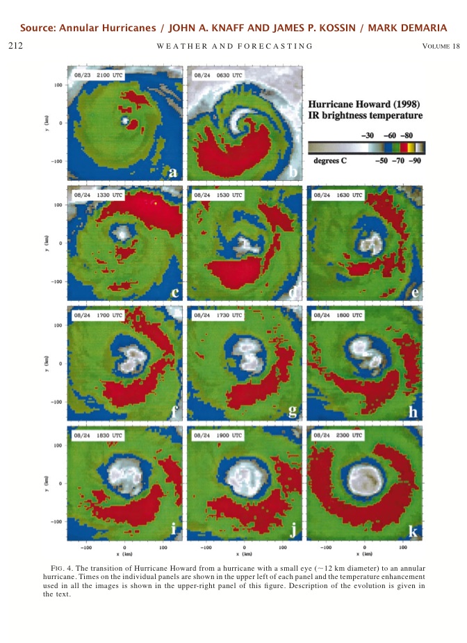
Extracted page from Annular Hurricanes by Knaff, Kossin, and DeMaria showing Hurricane Howard, 1998
|
danielw
|
| (Moderator) |
| Mon Sep 05 2011 02:15 PM |
|
|
|
|
nice catch. The following two photos appear back up the possibility of the annular Eye. Notice the extremely nice outflow around the periphery as evidenced by the high thin cirrus, horsetail clouds.
Time difference is about 75 minutes between the two photos.


Latest GOES Visible.. Eye centered.

| MichaelA |
| (Weather Analyst) |
| Mon Sep 05 2011 02:18 PM |
|
|
|
|
That does seem to be what may be happening with Katia. Also, using Knaff's mean wind speed, does that mean that Katia could intensify to a 125mph storm rather quickly?
|
danielw
|
| (Moderator) |
| Mon Sep 05 2011 02:27 PM |
|
|
|
|
It would be interesting to see if Katia actually goes above the latest SHIPS forecast. I believe the max wind forecast was 104 knots, or 120 mph.
Wait and see. As with all tropical cyclones.
Tropical Storm Lee has given me 7.53 inches since Friday, and it is still raining.
Never underestimate the Weather.
| Random Chaos |
| (Weather Analyst) |
| Mon Sep 05 2011 02:32 PM |
|
|
|
|
Look at the new IR image of Katia and the eye becoming much more round and the deep convection fully encircling the eye:

|
danielw
|
| (Moderator) |
| Mon Sep 05 2011 02:52 PM |
|
|
|
|
HURRICANE KATIA DISCUSSION NUMBER 30
NWS NATIONAL HURRICANE CENTER MIAMI FL AL122011
1100 AM AST MON SEP 05 2011
KATIA APPEARS TO HAVE GONE THROUGH AN EYEWALL REPLACEMENT AND NOW
HAS A 30 N MI WIDE EYE SURROUNDED BY A RELATIVELY NARROW BAND OF
THE COLDEST CLOUD TOPS. DVORAK INTENSITY ESTIMATES HAVE RISEN TO
T5.0 FROM TAFB AND SAB...AND THE OBJECTIVE NUMBERS ARE AT T5.5.
THE INITIAL INTENSITY IS THEREFORE BEING RAISED TO 95 KT....
...DUE TO THE EYEWALL REPLACEMENT...IT APPEARS THAT THE WIND FIELD HAS
EXPANDED A BIT...AND THIS IS REFLECTED IN THE ANALYSIS AND FORECAST.
| Random Chaos |
| (Weather Analyst) |
| Mon Sep 05 2011 03:02 PM |
|
|
|
|
Here is what confounds me about Katia. We have a Category 2 hurricane with 95kt winds that has gone through an ERC and has a giant well defined eye.
Normally ERCs don't occur until strong Cat 3 or better storms, with most ERCs happening in Cat 4 and Cat 5 storms. Further, large eyes generally do not occur in category 2 storms. And you generally need at least a category 3 storm before you get a well defined eye of any size.
How long will this storm stay at category 2 before the wind speeds and pressure catch up with it's significant structural changes?
From the 11am NHC discussion:
WITHIN THE NEXT 24 HOURS OR SO...THE HURRICANE WILL BE MOVING OVER OCEAN HEAT CONTENT VALUES THAT DO NOT NORMALLY SUPPORT SIGNIFICANT INTENSIFICATION.
This is actually a classic requirement for an annular storm. Annular storms tend to need lower SSTs than the traditional hurricane and also a light sheer environment, also present.
|
Ed Dunham
|
| (Former Meteorologist & CFHC Forum Moderator (Ed Passed Away on May 14, 2017)) |
| Mon Sep 05 2011 05:27 PM |
|
|
While Katia does exhibit some of the fundamentals for an annular hurricane, she is not quite there yet. Here is a good definition of Annular hurricanes from Wikipedia:
Annular Hurricane
Note that one of the formation requirements IS an eyewall replacement cycle. Another is a lack of banding features - and Katia still has a feeder band to the northeast. SSTs are at 28C which is within the acceptable range, but its on the high side. Although highly uncommon I've seen ERCs in Cat I and Cat II storms. Why they happen in some weaker hurricanes but not others is still one of the mysteries of hurricanes.
Regarding the size of the eye, its actually a misconception that a large eye size normally means a stronger hurricane. In August, 2000, Hurricane Alberto varied from a Tropical Storm to a Cat III Hurricane over a period of almost 3 weeks and was considered to be annular at various times during its evolution - including Cat I in the north Atlantic - with a 60 mile wide eye. In 1978, Hurricane Fico in the eastern and central Pacific moved to the west just to the north of 15N for 9 straight days with a 60 mile wide eye and intensities that varied from Cat I to Cat IV, but Fico was not annular. Fico still had a 60 mile wide eye when it passed southeast of the Big Isle on August 20th as a Cat II. However, you are probably correct that an annular hurricane always has a large eye.
Maybe Katia will get to the annular state in a day or so. Certainly a topic of good discussion as long as we can keep it focused on Katia.
ED
| Ed in Va |
| (Weather Master) |
| Tue Sep 06 2011 12:53 AM |
|
|
Hmmm...looks like the 18 GFDL moved quite a bit west...have to see if it's a trend.
I was at the soundside of OBX this weekend. My house had 16" of water in the basement. The rd outside ent from dry to chest- high water in about an hour at the end of Irene. Worst flooding there that anyone could remember. The oceanfront, in comparison, was completely untouched. Not so to the south on Hatteras Island, which will be without a road for about a month.
Re my gfdl comment...I just realized I was looking at the 95l model...which shows a different path for Katia than the Katia model itself.