| cieldumort |
| (Moderator) |
| Sat Aug 26 2023 08:09 AM |

|
|
|
11PM EDT 27 August 2023 Update
Idalia appears to be organizing at a breakneck pace tonight for what was, wind-wise at least, a "low end" tropical storm, and could very well be found to have become a hurricane by morning.
Floridians need to be aware that this cyclone has the potential to become one of those rare high-end hurricanes capable of producing serious devastation and loss of life, and take the necessary steps to protect life and property within the next day, as once conditions begin deteriorating, such precautions can be impossibly challenging to take.
Models are ingesting flight after flight of recon data now, and this should assist forecasters. We go into them in greater detail in the Idalia Forecast Lounge , which is also a good place to discuss pure informed speculation and best guesses as to Idalia's future.
5PM EDT 27 August 2023 Update
A Hurricane Watch has been issued for the Gulf coast of Florida
from Englewood to Indian Pass, including Tampa Bay.
A Storm Surge Watch has been issued for the Gulf coast of Florida
from Chokoloskee to Indian Pass, including Tampa Bay.
A Tropical Storm Watch has been issued for the Gulf coast of
Florida south of Englewood to Chokoloskee, and for the Dry Tortugas.
11:20AM EDT 27 August 2023 Update
TD#10 is Now Tropical Storm Idalia.
Update written immediately before special update to Idalia:
Landfall is forecast Wednesday somewhere along the Florida west coast as a Category 1 hurricane, those at and to the right of the landfall point are most likely to see the impacts, impacts may be felt well east of the cone. Note uncertainty for track and intensity is high, so further adjustments to the track and intensity in the future may occur. TD#10 may become Tropical Storm Idalia at any time later today. Recon aircraft is out there this morning to help improve the forecasts, but those along the West coast of Florida should use today to prepare as there's a sales tax holiday for hurricane supplies going on this week.
Especially for this angle of approach (Charley and Ian are the most recent examples, but this could go left or right), do not base on the track, even if the forecast track occurs exactly as is the Tampa area will still see impacts of some surge along the coast and heavy rainfall, so please do not focus on the exact forecast track, since strong winds, heavy rains and dangerous storm surges extend well away from the center. Since TD#10 is meandering this morning near Cozumel there's an extra bit of uncertainty, Movement away from the Yucatan Peninsula isn't expected until tomorrow.
Bermuda should also watch Franklin in case the threat moves closer.
7:30AM EDT 27 August 2023 Update
Idalia-to-be (TD TEN) and Hurricane Franklin are being aggressively flown by recon today, and this invaluable data will be fed into the models, forecast models which have been especially struggling a bit with TEN, and forecasters too.
By the end of the day we should be able to have greater confidence in the forecasts, but this is not to say that impacts won't be felt. There is already high confidence that a then-hurricane Idalia will make landfall somewhere along the west coast of Florida, and that a then-Major Hurricane Franklin will be within striking distance of Bermuda.
4:30PM EDT 26 August 2023 Update
NHC Advisories are being issued TD TEN, Idalia-to-be
1:30PM EDT 26 August 2023 Update
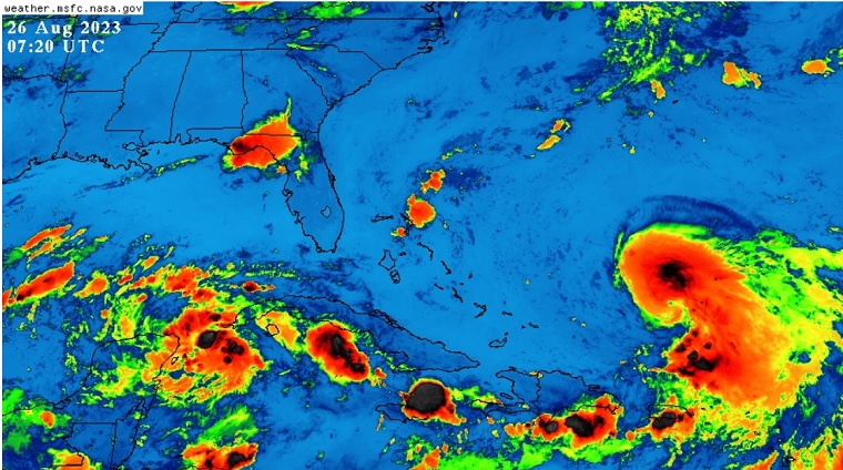
For all practical intents and purposes, if not literally, Invest 93L is now a tropical cyclone just off the northeastern coast of the Yucatan. Unfortunately, we have had neither recon nor satellite wind data available to confirm this. It would be best to treat 93L as a compact tropical depression or storm and begin taking precautions for a landfalling northeastern Gulf of Mexico TC, and potentially a very strong one.
Governor Desantis has declared a precautionary State of Emergency for 33 Florida counties. The counties included are: Alachua, Bay, Calhoun, Charlotte, Citrus, Columbia, DeSoto, Dixie, Franklin, Gadsden, Gilchrist, Gulf, Hamilton, Hardee, Hernando, Hillsborough, Jefferson, Lafayette, Lee, Leon, Levy, Liberty, Madison, Manatee, Marion, Pasco, Pinellas, Polk, Sarasota, Sumter, Suwannee, Taylor, and Wakulla.
Original Update
Left: Invest 93L (Likely Idalia-to-be) and Right: Franklin
INVEST 93L
The disturbance in the northwestern Yucatan continues to organize and as of this update is getting much more of the "look and feel" of a bona fide tropical cyclone. NHC development odds as of 2:00AM ET are up to 60%/90%, possibly conservative, and Watches and Warnings for a verified or Potential Tropical Cyclone could be issued at any time this weekend.
Conditions for further development and intensification of both Invest 93L (almost certainly Idalia-to-be) and Tropical Storm Franklin are favorable to very favorable. Sea surface temperatures are exceptionally supportive, shear is modest to light, the air moist, and the season is about peak.
The next name on the list is Idalia (Pronounced ee-DAL-ya).
The Lounge on 93L is up and regularly updating: Idalia Forecast Lounge
Tropical Storm Franklin
Franklin recently jumped a bit northeastward into deeper convection and thus right of forecast position. With this, NHC has updated the cone a little to the east of the last advisory, and on this track Franklin will likely sideswipe Bermuda from the west sometime between Sunday night and Monday (timing differences between models).
Elsewhere, we continue to monitor a few other areas in the central to eastern Tropical Atlantic, most of which would be incline to head poleward.
{{StormLinks|Idalia|10|10|2023|10|Idalia}}
{{StormLinks|Franklin|08|8|2023|08|Franklin}}
{{StormLinks|Gert|06|6|2023|06|Gert}}
{{StormLinks|92L|92|11|2023|92L|Invest 92L}}
{{TampaMedia}}
{{PanhandleMedia}}
{{SWFloridaMedia}}
{{NortheastGulfRadar}}
{{BermudaNews}}
MikeC
|
| (Admin) |
| Sat Aug 26 2023 09:53 AM |
|
|
It's important to note, its unlikely for anything named or depression to form until Late Sunday or even Monday, There may be potential advisories a little before then, particularly if it doesn't form until Monday. Still most likely is somewhere near the Big Bend Wednesday as a strong Tropical Storm, but with a high degree of uncertainty, especially on strength since the hurricane models (HAFS/HWRF) still show a hurricane at landfall.
| cieldumort |
| (Moderator) |
| Sat Aug 26 2023 01:25 PM |
|
|
|
|
I tend to disagree with the models that hold off development until Sunday/Monday. First light confirms that 93L is possibly already a T.C. We have not had a decent SCAT pass in almost 24 hours, and recon has solely been flying Franklin. 93L's structure has been missed by more recent SCAT passes as the area of interest may be relatively small, which also raises the question of how much stronger than modeling could it get, given its smaller size and potential to be missed by the models.
Intensity-wise, overnight ship reports of up to 45 knots were noted in the northeast quadrant of the incipient cyclone.
| IsoFlame |
| (Weather Analyst) |
| Sat Aug 26 2023 07:01 PM |

|
|
|
The deep convective burst this morning into mid-day near the western tip of Cuba has my attention.
Question for those with experience in tropical meteorology: How do these convective bursts (if sustained for a decent period of time, say for 3-6 hours) interact with the LLC, in fledgling systems- and consequently initialization of the center of a developing tropical cyclone?
| IsoFlame |
| (Weather Analyst) |
| Sat Aug 26 2023 07:12 PM |
|
|
|
|
Quote:
I tend to disagree with the models that hold off development until Sunday/Monday. First light confirms that 93L is possibly already a T.C. We have not had a decent SCAT pass in almost 24 hours, and recon has solely been flying Franklin. 93L's structure has been missed by more recent SCAT passes as the area of interest may be relatively small, which also raises the question of how much stronger than modeling could it get, given its smaller size and potential to be missed by the models.
Intensity-wise, overnight ship reports of up to 45 knots were noted in the northeast quadrant of the incipient cyclone. [/qoute]
I wholeheartedly agree with you based on my limited technical knowledge of tropical meteorology. I'm not educated in the fine details as most of the members on this forum (I flunked Calc 3 @ FSU (I blamed it on the Chinese instructor who spoke broken English- but numbers don't know language!) and did not pursue a degree in Met), but I'm pretty good at analyzing satellite loops and the raw data that models crunch .
| cieldumort |
| (Moderator) |
| Sat Aug 26 2023 09:08 PM |
|
|
|
|
Tropical Depression Ten Advisory Number 1
NWS National Hurricane Center Miami FL AL102023
400 PM CDT Sat Aug 26 2023
WATCHES AND WARNINGS
--------------------
CHANGES WITH THIS ADVISORY:
The government of Mexico has issued a Tropical Storm Warning for
the Yucatan Peninsula of Mexico from Tulum to Rio Lagartos,
including Cozumel.
The government of Cuba has issued a Tropical Storm Watch for
extreme western Cuba for the provinces of Pinar Del Rio and the
Isle of Youth.
SUMMARY OF WATCHES AND WARNINGS IN EFFECT:
A Tropical Storm Warning is in effect for...
* Yucatan Peninsula from Tulum to Rio Lagartos, including Cozumel
A Tropical Storm Watch is in effect for...
* Pinar del Rio and the Isle of Youth
A Tropical Storm Warning means that tropical storm conditions are
expected somewhere within the warning area within 36 hours.
A Tropical Storm Watch means that tropical storm conditions are
possible within the watch area, generally within 48 hours.
For storm information specific to your area, please monitor products
issued by your national meteorological service.
|
MikeC
|
| (Admin) |
| Sat Aug 26 2023 10:45 PM |
|
|
Yep it was like the storm woke up this morning, with it sitting generally in the same area for the next day or two it'll be under some very warm water, recon will help since there's a LOT of recon going into this tomorrow. Surprised me how quickly it got together today. It will need to be monitored closely as there's still quite a few surprises. Franklin still needs to be watched by Bermuda also. Models will be better seeded tomorrow night.
| cieldumort |
| (Moderator) |
| Sun Aug 27 2023 11:29 AM |
|
|
|
|
WEATHER RECONNAISSANCE FLIGHTS
CARCAH, NATIONAL HURRICANE CENTER, MIAMI, FL.
1225 PM EDT SAT 26 AUGUST 2023
SUBJECT: TROPICAL CYCLONE PLAN OF THE DAY (TCPOD)
VALID 27/1100Z TO 28/1100Z AUGUST 2023
TCPOD NUMBER.....23-088
I. ATLANTIC REQUIREMENTS
1. HURRICANE FRANKLIN
FLIGHT ONE - TEAL 76 FLIGHT TWO - TEAL 74
A. 27/2330Z A. 28/1130Z
B. AFXXX 1408A FRANKLIN B. AFXXX 1508A FRANKLIN
C. 27/2100Z C. 28/0845Z
D. 27.0N 68.8W D. 28.5N 69.4W
E. 27/2300Z TO 28/0230Z E. 28/1100Z TO 28/1430Z
F. SFC TO 10,000 FT F. SFC TO 10,000 FT
G. FIX G. FIX
2. SUSPECT AREA (NW CARIBBEAN - AL93)
FLIGHT ONE - NOAA 43 FLIGHT TWO - TEAL 71
A. 27/1400Z A. 27/1500Z
B. NOAA3 01DDAA TDR B. AFXXX 02DDA INVEST
C. 27/1000Z C. 27/1230Z
D. 21.3N 86.5W D. 21.3N 86.5W
E. 27/1330Z TO 27/1630Z E. 27/1430Z TO 27/1900Z
F. SFC TO 15,000 FT F. SFC TO 15,000 FT
G. TAIL DOPPLER RADAR G. LOW LEVEL INVEST
FLIGHT THREE - NOAA 49 FLIGHT FOUR - TEAL 72
A. 28/0000Z A. 28/0530Z
B. NOAA9 03DDA SURV B. AFXXX 0410A CYCLONE
C. 27/1730Z C. 28/0300Z
D. NA D. 21.8N 86.5W
E. NA E. 28/0500Z TO 28/0830Z
F. 41,000 TO 45,000 FT F. SFC TO 10,000 FT
G. SYNOPTIC SURVEILLANCE G. FIX
FLIGHT FIVE - NOAA 49 FLIGHT SIX - TEAL 73
A. 28/1200Z A. 28/1130Z,1730Z
B. NOAA9 0510A CYCLONE B. AFXXX 0610A CYCLONE
C. 28/0530Z C. 28/0900Z
D. NA D. 22.1N 86.5W
E. NA E. 28/1100Z TO 28/1730Z
F. 41,000 TO 45,000 FT F. SFC TO 15,000 FT
G. SYNOPTIC SURVEILLANCE G. FIX
FLIGHT SEVEN - NOAA 43
A. 28/1200Z
B. NOAA3 0710A CYCLONE
C. 28/1000Z
D. 22.1N 86.5W
E. 28/1130Z TO 28/1530Z
F. SFC TO 15,000 FT
G. TAIL DOPPLER RADAR
3. OUTLOOK FOR SUCCEEDING DAY:
A. CONTINUE 12-HRLY FIXES ON FRANKLIN WHILE IT REMAINS
A THREAT.
B. CONTINUE 6-HRLY FIXES ON AL93 IF IT DEVELOPS.
C. TWO ADDITIONAL NOAA G-IV SYNOPTIC SURVEILLANCE MISSIONS
OVER THE GULF OF MEXICO DEPARTING KLAL AT 28/1730Z AND
29/0530Z.
D. TWO ADDITIONAL NOAA P-3 TAIL DOPPLER RADAR MISSIONS INTO
AL93, DEPARTING KFLL AT 28/2200Z AND 29/1000Z.
| OrlandoDan |
| (Weather Master) |
| Sun Aug 27 2023 07:50 PM |

|
|
|
I expect positive vorticity advection and diffluent upper-level flow to the east of the trough and will likely be conducive for strengthening
| Prospero |
| (Storm Tracker) |
| Sun Aug 27 2023 08:50 PM |
|
|
|
|
It has been a pretty nice day here in the Tampa Bay area. The calm before the storm...
| cieldumort |
| (Moderator) |
| Sun Aug 27 2023 10:47 PM |
|
|
|
|
Fwiw, #Idalia's current analyzed minimum central pressure (SLP) on the latest NHC advisory is in the bottom 4% of all 35-40 knot tropical storms in this part of the Atlantic basin since 1970.
— Eric Webb (@webberweather) August 27, 2023
This implies #Idalia is an unusually deep, large storm & there's a good chance #Idalia… pic.twitter.com/TzGI4FPvhJ
|
MikeC
|
| (Admin) |
| Mon Aug 28 2023 04:15 AM |
|
|
For surge projections see https://cera.coastalrisk.live/ and the NHC's at https://www.nhc.noaa.gov/refresh/graphics_at5+shtml/025839.shtml?inundation#contents