cieldumort
Moderator

Reged:
Posts: 2305
Loc: Austin, Tx
|
|
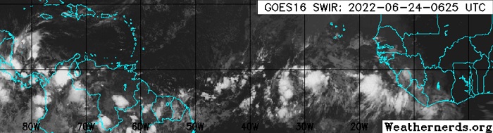
Invest 94L in the far eastern Atlantic 6-24-22 0625z IR Image cr. Weathernderds.org
A stout tropical wave in the eastern Atlantic has the attention of an increasing number of models and indeed the for unusually early Main Development Region Tropical Cyclogenesis, with a 50% assigned chance of becoming a TC within 5 days, and this could be conservative.
Models are generally on fire for 94L in a way that sort of brings back memories, of 2005, and it is hard to find fault with their bullishness. While there is a long time for us to keep an eye on this wave and it is currently far out in the Atlantic, given the unseasonably favorable conditions for its development and model tracks that take it through the Caribbean as well as potentially into the Gulf of Mexico, we are starting a lounge on newly-Invest tagged 94L at this time.
PTC2 "Ptnl 2" sufficiently organized overnight June 30th and on July 1 has become Tropical Storm Bonnie. The title has been updated accordingly.
Edited by cieldumort (Fri Jul 01 2022 02:41 PM)
|
cieldumort
Moderator
Reged:
Posts: 2305
Loc: Austin, Tx
|
|
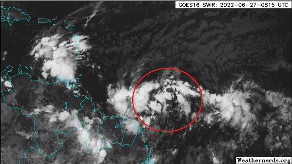
As of 3AM AST June 27, Invest 94L is looking increasingly well put together at the surface, with some indications that convection is beginning to organize with the help of overnight DMAX. It will be informative to see how much of this remains during the day, as the same has happened prior only to give up the ghost throughout the day.
At first blush, track looks straight forward - southerly - into the southern Caribbean if not even brushing northernmost South America, then plop into the southwesternmost Caribbean, and then off to somewhere between Central America and perhaps the southernmost Yucatan. There are some minority reports from the models, however, and they are far from few. A number of ensembles from the Globals suggest a track heading more towards Belize/Yucatan, and crossing into the southwestern GOM, is not off the table.
Intensity, while notoriously difficult to forecast, is still bullish, with many models and ensembles ramping 94L into a rare June and/or early July hurricane somewhere between the eastern Caribbean and Central America. There are even a few plausible ensembles that track into the western Gulf as a Major. Definitely all lounge talk this far out, and probably nothing to make any sort of planning around until more is known.
|
cieldumort
Moderator
Reged:
Posts: 2305
Loc: Austin, Tx
|
|
For the most part, the hurricane-centric models take 94L, which is looking much more organized than just a few days ago, into the Caribbean with intensification up to Cat 2/3. Globals on the other hand, and unsurprisingly, are more gradual.
|
|


 Threaded


