CFHC

Reged:
Posts: 149
Loc: East Central Florida
|
|
This will be updated during the day as more information on Edouard is made available.
Noon Update
Minimal Tropical Storm Edouard has been drifting west southwest over the past couple of hours, however, high pressure aloft over the eastern Gulf has been building eastward during the night and should change the movement of Edouard to a more southwesterly direction.
This will place the center of the storm north of the Cape near Daytona Beach later this evening.
Some additional intensification is likely before landfall, so Edouard should retain its Tropical Storm status.
The Position at 11am was near 30Nand 80W.
Most of the rain and stronger wind associated with this system are located to the east and south of the center, and northwesterly upper level wind shear continues to disrupt the cyclone. Late this evening into Thursday, west to northwest winds will approach tropical storm force along the coast.
Squalls with heavy downpours are likely to start as early as this afternoon, becoming more frequent tonight and Thursday along the central and north Florida coast. The National Hurricane Center has issued a Tropical Storm Warning from Titusville northward along the Florida coast and a Tropical Storm Watch from Titusville southward to Sebastian Inlet.
The storm in the northern gulf is coming together, but the situation with Edouard and the rest makes any real forecasting a nightmare still for a bit longer.
Noon update special thanks to Ed Dunham.
8:30 AM Update
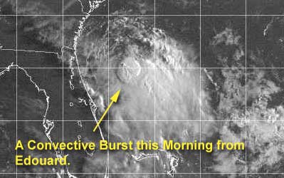
Edouard weakened quite a bit yesterday and much of the convection was sheared off to the east, but this morning it appears that it may be refiring a bit. I think it'll maintain itself as a tropical storm for a while longer. Rain from the storm is being felt along the coastal edge of Volusia now. But the storm itself is still offshore about 80 miles slowly moving. The last public advisory from the stated the windspeed at 40MPH, but new Aircraft Recon reports that occured after the advisory now show it at 50MPH.
The fact that it is over extremely warm water has kept the system from outright dying because of the massive amount of shear it has been receiving. This storm is a survivor, any chance to strengthen it can get, it will take. However, there will not be that many chances for it io do so. I expect it to weaken again later in the day... but maintain itself as a tropical storm.
If the official track holds it'll reach the coast in the overnight hours tonight, and the rain will occur mostly on the eastern side of the system. (This all could change however....) Plenty of folks around the St. Johns really don't need the rain.
Updates will occur today here as needed.
Outside of Edouard, the system in the east atlantic is getting some shear that will keep its developmental possibilities in check for a while (although there is a wave over africa now that may slide out fairly strong later).
Also the Northern gulf is active, but still nothing at the surface. This is one to watch as well, but it still will take a while. Once this does get going, however...
NRL Monterey Marine Meteorology Division Forecast Track of Active Systems (Good Forecast Track Graphic and Satellite Photos)
NASA GHCC Interactive Satellite images at:
North Atlantic Visible (Daytime Only), Infrared, Water Vapor
Some forecast models:
NGM, AVN, MRF, ETA ECMWF
DoD Weather Models (NOGAPS, AVN, MRF)
AVN, , , , , UKMET
Other commentary at Mike Anderson's East Coast Tropical Weather Center, Accuweather's Joe Bastardi, Hurricane City, Gary Gray's Millennium Weather, Barometer Bob's Hurricane Hollow, Snonut, Ed Dunham and Jason M in our Storm Forum Even more on the links page.
- [mike@flhurricane.com]
Edited by MikeC (Wed Sep 04 2002 04:13 PM)
|
ShawnS
Storm Tracker
Reged:
Posts: 226
Loc: Pearland,Tx
|
|
Anyone see a chance of anything developing from the stuff in the northwest gulf? I've been trying to see if there is a motion out of it but it looks like it is stationary. I know the focus is on Eddie right now, but this activity in the gulf could really spring up on us in a hurry. I'm not saying it will, but every time I look at a new sat. pic. it looks more impressive.
|
PFSThunder
Weather Watcher

Reged:
Posts: 38
Loc: Charleston, SC
|
|
Looking at the long range radar out of Melbourne, it looks like the center is wrapping tightly west of St Augustine. Last night the signature was wider, now the bandsfeeding the system are closer together. Something to be watched. Weather service being very careful with any changes to the forecast.
--------------------
Go Boilermakers
|
squirralee
Weather Hobbyist

Reged:
Posts: 80
Loc: Mims, Florida
|
|
Okay am I crazy or is the trying to put another tropical system off the coast of Brevard after Ed goes over the state. 
http://www.essc.psu.edu/rhart-cgi-bin/gfdltc2.cgi?time=2002090406-edouard05l&field=Sea+Level+Pressure&hour=Animation
|
Jax Chris
Weather Watcher
Reged:
Posts: 28
Loc: Jacksonville Beach, FL
|
|
I've always liked the central pressure for a predictor of how the intensity of a storm is going to go. The lower the pressure, the more rapidly the storm's moving air up its core, and so the more rapidly air has to flow into the storm to replace that air. Yesterday we saw the pressure drop down to 1003, followed by an increase in intensity. The pressure went back up, and wind speeds dropped. The 2 a.m. recon had the central pressure down to 1002, where it's remained even up through the 8 a.m. recon. So we've got the pressure and a flare-up of convection on the plus side, and the shear on the minus side. Despite the forecast of weakening before landfall, I suspect Edouard has a good chance of strengthening. Hopefully, however, the shear will win out before Edouard gets to the coast.
Chris
|
Anonymous
Unregistered
|
|
I don't think so, but it's putting a major hurricane in the Mobile/Pensacola area. Probably a bit overdone, but the track is feasible.
|
Colleen A.
Moderator

Reged:
Posts: 1432
Loc: Florida
|
|
A few things I've noticed about Ed...TWC was VERY CERTAIN earlier that he would be almost dead by the time he reached the coast. Now they are backing off of that statement. Eduardo has pretty much stalled off the coast of Central Florida, looks better and doesn't have a definite movement that one can follow for any length of time (say, like 5 minutes), so....we don't know what he's doing or when he is gonna do it, and how strong he will/won't be if he keeps this type of behavior up. Nothing is ever a sure bet when it comes to tropical weather and if he was getting closer to the coast I would say that a certain forecast could be right but the very fact that he's 90 miles east just sitting there barely moving does give him time do something.
We just have to wait and see what that "something" is. Hopefully, we will know that before my kids start college.

--------------------
You know you're a hurricane freak when you wake up in the morning and hit "REFRESH" on CFHC instead of the Snooze Button.
|
Anonymous
Unregistered
|
|
Eduardo should be downgraded soon, 1006 presure and only 25K winds,,,damn hes weak. Oh well which system is next????? Maybe we can all fly planes westward ahead of him causing the winds briefly to turn w in the upper level and watch him go up briefly 5 mph,LOL jk anyways if he makes it to the gulf the shawn will at least ask a new question every 5 min about hitting Houston.
|
troy2
Storm Tracker
Reged:
Posts: 227
Loc: cocoa beach
|
|
In reply to:
Okay am I crazy or is the trying to put another tropical system off the coast of Brevard after Ed goes over the state.
I saw the same thing. Small set of closed isiobars within the circulation of Edouard. It is an interesting thing. Not sure what it is, though doubt its a new sytem
|
StormHound
Weather Guru
Reged:
Posts: 187
Loc: Orlando, FL
|
|
The 24kts is for the SW quad, not the center. The NE quad was tagged at 43kts an hour or two ago. I don't think Ed is weakening yet.
As far as the , yes there is a swirl at the end of the loop, but it would not be strong enough to be considered even a TD.
--------------------
Storm Hound
Computer Geek
|
Cycloneye
Storm Tracker
Reged:
Posts: 373
Loc: Puerto Rico
|
|
Against all the shear it has encountered still the storm manages to hang on and complicate the forecasts of the models and the folks of the TPC.
--------------------
My 2004 hurricane season forecast=13/8/3
Edited by Cycloneye (Wed Sep 04 2002 02:18 PM)
|
Anonymous
Unregistered
|
|
Eddie looks to have lost some of his signature in the past hour. I am having a hard time picking out the center on radar or sat. It was very clear earlier this morning. I believe the weakening has continued.
|
Anonymous
Unregistered
|
|
>>jk anyways if he makes it to the gulf the shawn will at least ask a new question every 5 min about hitting Houston.
Maybe he will, but he doesn't hide behind the anonymous tag when asking those questions or making pointed comments.
Hey Shawn,
I don't know what's up down there. There is obviously some low pressure at the surface, but there really aren't any buoys near where it probably is centered (elongated south of New Iberia/Franklin over toward Corpus/Kings Ranch). All the surrounding buoys show fairly high pressure including here in the city. Most of the pressures are up from yesterday by .02-.04 and are ranging from 29.91 to 30.3. So your guess is as good as mine. I fully expect to wake up tomorrow again and see blossoming convection. But what is the ultimate solution?
Steve
|
Anonymous
Unregistered
|
|
From the looks of the recent sattelites I believe we will at least get an invest out of this. BarryB
|
Anonymous
Unregistered
|
|
Looks like the TPC is getting interested also
|
HanKFranK
User

Reged:
Posts: 1841
Loc: Graniteville, SC
|
|
shawn, is talking in the 11am outlook like the system off tx/la may develop. the 00Zavn has something going out there, which absorbs edouard down the road. avn also stalls it offshore, but this is probably poor initialization (though this thing HAS been sitting off the coast for a couple of days). seeing as edouard is getting the nw outflow jet right across the top, and that system has parts at least that are under a large well defined upper ridge.. yeah, if that thing starts developing it could really wreck all the forecasts.
dolly has been decoupled, now a low cloud swirl in a hostile environment. dont count it out until totally dissipated though.
somebody mentioned that has another system behind edouard.. this is complicated. a number of models have been suggesting that a low would form south of bermuda due to an amplification, the one that was supposed to insure dolly's exit. some models loitered it, some split it, some jetted it out to the northeast. and some caught it under the building ridge. now this morning i see a slightly turning disturbance out in the general area, sheared and beaten as edouard was.. have to see if it persists.. i've been expecting something around there.
95L still has no deep convection but not any weaker. water temps underneath wont be at 26C until later on today, but it is moving towards the ridging ahead of dolly's killer trough. you know what i'm implying might happen..
can see the weak swirl to the ssw of 95L on visibles this morning, drifting west around 13N38W. 95L is caught in the mid layer flow and is going to breeze by to the north.. leaving this persistent swirl in its wake. it is still associated with convection, and waters down there are quite a bit warmer.
final note: bastardi says the next wave is energetic. 10W he said.. that means it comes out some time tomorrow.
so thats it.. four disturbed areas.. probably two will give us new storms.
HF 1531z04september
|
Anonymous
Unregistered
|
|
plane going in this afternoon
|
Anonymous
Unregistered
|
|
????????
|
Anonymous
Unregistered
|
|
I was wondering about that. With all the planes flying around in Edouard you'd think that they would send something into the GOM area that is looking most interesting.
I was thinking Fay in the Gulf and Gustav out in the Atlantic.
Interesting thoughts a few posts back Hank I think, thanks Bobbi
|
Anonymous
Unregistered
|
|
As for that model run just now.. beats me what its trying to do but imagine it could only happen if when exiting Florida Edouard (happy to get away from Florida) becomes a much stronger system.
Could maybe see Edouard wandering around A1A and being pulled west by a strong storm in the Gulf but the timing looks off
|


 Threaded


